مارلبورو، مساتشوستس
مارلبورو، مساتشوستس
Marlborough, Massachusetts | |
|---|---|
 Main street | |
 الشعار | |
 Location in Middlesex County in Massachusetts | |
 مارلبورو، مساتشوستس الموقع في الولايات المتحدة | |
| Coordinates: 42°20′45″N 71°33′10″W / 42.34583°N 71.55278°W | |
| البلد | الولايات المتحدة |
| الولاية | مساتشوستس |
| المقاطعة | مدلسكس |
| Settled | 1657 |
| Incorporated (town) | 20 سبتمبر 1660 |
| Incorporated (city) | 1890 |
| Government | |
| • Type | Mayor-council city |
| • العمدة | Arthur G. Vigeant[1][2] |
| Area | |
• Total | 22٫10 ميل² (57٫23 كم²) |
| • Land | 20٫86 ميل² (54٫03 كم²) |
| • Water | 1٫24 ميل² (3٫20 كم²) |
| Elevation | 450 ft (137 m) |
| Population (2020) | |
• Total | 41٬793 |
| • Density | 2٬003٫50/sq mi (773٫51/km2) |
| Demonym | Marlboronian |
| Time zone | UTC−5 (الشرقية) |
| • Summer (DST) | UTC−4 (Eastern) |
| ZIP Code | 01752 |
| Area code | 508/774 |
| FIPS code | 25-38715 |
| GNIS feature ID | 0611360 |
| Website | www.marlborough-ma.gov |
مارلبورو Marlborough هي مدينة في مقاطعة مدلسكس، مساتشوستس، الولايات المتحدة. التعداد كان 41,793 نسمة في تعداد 2020.[4] Marlborough became a prosperous industrial town in the 19th century and made the transition to high technology industry in the late 20th century after the construction of the Massachusetts Turnpike.
Marlborough was declared a town in 1660. It was incorporated as a city in 1890 when it changed its municipal charter from a New England town meeting system to a mayor–council government.
التاريخ
John Howe in 1656 was a fur trader and built a house at the intersection of two Indian trails, Nashua Trail and Connecticut path.[5] He could speak the language of the Algonquian Indians though the local tribe referred to themselves as the Pennacooks. The settlers were welcomed by the Indians because they protected them from other tribes they were at war with. In the 1650s, several families left the nearby town of Sudbury, 18 miles west of Boston, to start a new town. The village was named after Marlborough, the market town in Wiltshire, England. It was first settled in 1657 by 14 men led by Edmund Rice, John Ruddock, John Howe and a third John named John Bent ; in 1656 Rice and his colleagues petitioned the Massachusetts General Court to create the town of Marlborough and it was officially incorporated in 1660. Rice was elected a selectman at Marlborough in 1657. Sumner Chilton Powell wrote, in Puritan Village: The Formation of a New England Town, "Not only did Rice become the largest individual landholder in Sudbury, but he represented his new town in the Massachusetts legislature for five years and devoted at least eleven of his last fifteen years to serving as selectman and judge of small causes."[6]

The Reverend William Brimstead was the first minister of the Puritan church and Johnathan Johnson was the first blacksmith.
Marlborough was one of the seven "Praying Indian Towns" because they were converted to Christianity by the Rev. John Eliot of Roxbury. In 1674 a deed was drawn up dividing the land between the settlers and the natives. This is the only record of names of the natives.
The settlement was almost destroyed by Native Americans in 1676 during King Philip's War.
-
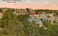 Bird's-eye view c. 1912
 -
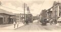 Main Street in 1906
 -
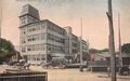 Shoe factory c. 1910
 -
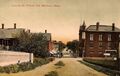 Lincoln Street c. 1908


الجغرافيا
Marlborough is located at 42°21′3″N 71°32′51″W / 42.35083°N 71.54750°W (42.350909, -71.547530).[7] According to the United States Census Bureau, the city has a total area of 22.2 ميل مربع (57 km2), of which, 21.1 ميل مربع (55 km2) of it is land and 1.1 ميل مربع (2.8 km2) of it (4.87%) is water. The Assabet River cuts across the northwest corner of the city. Within city limits are three large lakes, known as Lake Williams, Millham Reservoir and Fort Meadow Reservoir. (A portion of Fort Meadow Reservoir extends into nearby Hudson.)
Marlborough is crossed by Interstate 495, U.S. Route 20 and Massachusetts Route 85. The eastern terminus of Interstate 290 is also in Marlborough.
البلدات المجاورة
تقع مارلبورو في شرق مساتشوستس، ويحدها ست بلديات: برلين و هدسون و سدبري و فريمنگهام, ساوثبورو و نورثبورو.
الديمغرافيا
| السنة | تعداد | ±% |
|---|---|---|
| 1790 | 1٬554 | — |
| 1800 | 1٬735 | +11.6% |
| 1810 | 1٬674 | −3.5% |
| 1820 | 1٬952 | +16.6% |
| 1830 | 2٬077 | +6.4% |
| 1840 | 2٬101 | +1.2% |
| 1850 | 2٬941 | +40.0% |
| 1860 | 5٬911 | +101.0% |
| 1870 | 8٬474 | +43.4% |
| 1880 | 10٬127 | +19.5% |
| 1890 | 13٬805 | +36.3% |
| 1900 | 13٬609 | −1.4% |
| 1910 | 14٬579 | +7.1% |
| 1920 | 15٬028 | +3.1% |
| 1930 | 15٬587 | +3.7% |
| 1940 | 15٬154 | −2.8% |
| 1950 | 15٬756 | +4.0% |
| 1960 | 18٬819 | +19.4% |
| 1970 | 27٬936 | +48.4% |
| 1980 | 30٬617 | +9.6% |
| 1990 | 31٬813 | +3.9% |
| 2000 | 36٬255 | +14.0% |
| 2010 | 38٬499 | +6.2% |
| 2020 | 41٬793 | +8.6% |
| * = تقدير تعداد. المصدر: سجلات تعداد الولايات المتحدة وبيانات برنامج تقديرات السكان.[8][9][10][11][12][13][14][15][16][17][18] Source: | ||
المدن والبلدات الشقيقة
المدن
 – Akiruno, Tokyo, Japan from November 3, 1998
 - Ipatinga, Minas Gerais, Brazil from June, 2009
البلدات
 - Marlborough, Wiltshire, England, United Kingdom from 1657
انظر أيضاً
- Marlborough Country Club
- National Register of Historic Places listings in Marlborough, Massachusetts
المراجع
- ^ "Office of the Mayor". City of Marlborough, MA. Archived from the original on 10 September 2015. Retrieved 17 September 2015.
- ^ Laidler, John (4 October 2012). "Mayors, other area notables take sides in Senate race". The Boston Globe. Retrieved 17 September 2015.
Marlborough Mayor Arthur G. Vigeant, on the other hand, said he is backing the incumbent senator, Scott Brown, because the fellow Republican from Wrentham 'has been available for us in Marlborough ... I think he's done a good job.'
- ^ "2019 U.S. Gazetteer Files". United States Census Bureau. Retrieved July 25, 2020.
- ^ "Census - Geography Profile: Marlborough city, Massachusetts". U.S. Census Bureau. Retrieved September 18, 2021.
- ^ "Marlborough Massachusetts Genealogy". USGenWeb. Archived from the original on 2006-10-16. Retrieved 2007-03-01.
- ^ "Who was Edmund Rice?". The Edmund Rice (1638) Association, Inc. Retrieved 2007-05-14.
- ^ "US Gazetteer files: 2010, 2000, and 1990". United States Census Bureau. 2011-02-12. Retrieved 2011-04-23.
- ^ "TOTAL POPULATION (P1), 2010 Census Summary File 1, All County Subdivisions within Massachusetts". United States Census Bureau. Retrieved September 13, 2011.
- ^ "Massachusetts by Place and County Subdivision - GCT-T1. Population Estimates". United States Census Bureau. Retrieved July 12, 2011.
- ^ "1990 Census of Population, General Population Characteristics: Massachusetts" (PDF). US Census Bureau. 1990. Table 76: General Characteristics of Persons, Households, and Families: 1990. 1990 CP-1-23. Retrieved July 12, 2011.
{{cite web}}: Unknown parameter|month=ignored (help) - ^ "1980 Census of the Population, Number of Inhabitants: Massachusetts" (PDF). US Census Bureau. 1981. Table 4. Populations of County Subdivisions: 1960 to 1980. PC80-1-A23. Retrieved July 12, 2011.
{{cite web}}: Unknown parameter|month=ignored (help) - ^ "1950 Census of Population" (PDF). Bureau of the Census. 1952. Section 6, Pages 21-10 and 21-11, Massachusetts Table 6. Population of Counties by Minor Civil Divisions: 1930 to 1950. Retrieved July 12, 2011.
- ^ "1920 Census of Population" (PDF). Bureau of the Census. Number of Inhabitants, by Counties and Minor Civil Divisions. Pages 21-5 through 21-7. Massachusetts Table 2. Population of Counties by Minor Civil Divisions: 1920, 1910, and 1920. Retrieved July 12, 2011.
- ^ "1890 Census of the Population" (PDF). Department of the Interior, Census Office. Pages 179 through 182. Massachusetts Table 5. Population of States and Territories by Minor Civil Divisions: 1880 and 1890. Retrieved July 12, 2011.
- ^ "1870 Census of the Population" (PDF). Department of the Interior, Census Office. 1872. Pages 217 through 220. Table IX. Population of Minor Civil Divisions, &c. Massachusetts. Retrieved July 12, 2011.
- ^ "1860 Census" (PDF). Department of the Interior, Census Office. 1864. Pages 220 through 226. State of Massachusetts Table No. 3. Populations of Cities, Towns, &c. Retrieved July 12, 2011.
- ^ "1850 Census" (PDF). Department of the Interior, Census Office. 1854. Pages 338 through 393. Populations of Cities, Towns, &c. Retrieved July 12, 2011.
- ^ "1950 Census of Population" (PDF). 1: Number of Inhabitants. Bureau of the Census. 1952. Section 6, Pages 21-7 through 21-09, Massachusetts Table 4. Population of Urban Places of 10,000 or more from Earliest Census to 1920. Retrieved July 12, 2011.
{{cite journal}}: Cite journal requires|journal=(help) - ^ "Census of Population and Housing". Census.gov. Retrieved June 4, 2015.
للاستزادة
- 1871 Atlas of Massachusetts. by Wall & Gray.Map of Massachusetts. Map of Middlesex County.
- History of the Town of Marlborough, Middlesex County, Massachusetts. by Charles Hudson, and Joseph Allen. Published 1862, 544 pages.
- History of Middlesex County, Massachusetts, Volume 1 (A-H), Volume 2 (L-W) compiled by Samuel Adams Drake, published 1879 and 1880. 572 and 505 pages. Marlborough Section in Volume 2 page 137 by R. A. Griffin and E. L. Bigelow.
وصلات خارجية
- City of Marlborough, Massachusetts
- Marlborough Historical Society
- Marlborough Regional Chamber of Commerce
بلديات ومجتمعات Middlesex County، Massachusetts، الولايات المتحدة | ||
|---|---|---|
| Cities | 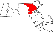 | |
| Towns |
| |
| CDPs | ||
| Other villages |
| |
| Footnotes | ‡This populated place also has portions in an adjacent county or counties | |
- Pages using gadget WikiMiniAtlas
- CS1 errors: unsupported parameter
- Short description is different from Wikidata
- Coordinates on Wikidata
- Articles with hatnote templates targeting a nonexistent page
- مارلبورو، مساتشوستس
- أماكن مأهولة تأسست في 1657
- تأسيسات 1657 في مساتشوستس
- مدن مساتشوستس
- مدن مقاطعة مدلسكس، مساتشوستس