خوتان
| ||||||||||||||||||||||||||||||||||||||||||||||||||||||||||
| ||||||||||||||||||||||||||||||||||||||||||||||||||||||||||


خوتان،[أ] هي بلدة واحة كبيرة في جنوب غرب شينجيانگ، ومنطقة ذاتية في غرب الصين. مدينة خوتان نفسها انفصلت عن ناحية خوتان الأكبر لتصبح منطقة ادارية بنفسها في أغسطس 1984. وهي مقر محافظة خوتان.
بتعداد 322,300 (تعداد 2010)، تقع خوتان في حوض تريم على بعد نحو 1,500 كم جنوب غرب العاصمة الإقليمية، أورومچي. وتقع إلى الشمال مباشرة من جبال كونلون، التي تعبرها ممرات سانجو, هندوطاش و إلچي. البلدة، الواقعة جنوب غرب ناحية يرقند، وجميع سكانها أويغور، هي مركز زراعي صغير. وكمحطة هامة على الفرع الجنوبي لطريق الحرير التاريخي، فقد اعتمدت خوتان دوماً على نهرين قويين - نهر قرة قاش و نهر اليشم الأبيض لإمدادها بالماء للحياة على الحافة الجنوبية الغربية لـصحراء تكلامكان الشاسعة. ومازال نهر اليشم الأبيض يجلب الماء للمدينة ويروي الواحة.[2][3]
أصل الاسم
The original name of Hotan is said to have been Godana, the name used in the Sanskrit cosmological texts. It carried the meaning of "land of cows". In Chinese, the same name was written as Yu-t'ien, pronounced as Gu-dana. The pronunciation changed over the years to Kho-tan. In the 7th century, Xuanzang tried to reverse interpret it in Sanskrit as Kustana. However, the Tibetans continued to call it Go-sthana, which also carried the meaning of "land of cows",[4][5]
التاريخ

تقع واحة خوتان في موقع استراتيجي عند تقاطع الفرع الجنوبي (والأقدم) من طريق الحرير الذي يربط بين الصين والغرب بأحد الطرق الرئيسية من الهند و التبت القديمتين إلى آسيا الوسطى والصين البعيدة، فقد وفرت مكاناً مناسباً للقاء حيث لا تنتقل البضائع فحسب، بل تنتقل التقنيات والفلسفات والأديان من ثقافة إلى أخرى.
خوتان البوذية

خوتان الإسلامية
كان يوسف قادر خان شقيق أو ابن عم الحاكم المسلم لقشغر و بالاساگون، الذي فقدت خوتان في عهده استقلالها وبين 1006 و 1165، أصبحت جزءاً من خانية القرة خانات. Later it fell to the خانية قرة خيتان, after which it was ruled by the المنغول.
When Marco Polo visited Khotan in the 13th century, he noted that the people were all Muslim. He wrote that:
Khotan was "a province eight days’ journey in extent, which is subject to the Great Khan. The inhabitants all worship Mahomet. It has cities and towns in plenty, of which the most splendid, and the capital of the province, bears the same name as that of the province…It is amply stocked with the means of life. Cotton grows here in plenty. It has vineyards, estates and orchards in plenty. The people live by trade and industry; they are not at all warlike".[6][7]
أسرة تشينگ

The town suffered severely during the Dungan Revolt (1862–77) against the Qing dynasty and again a few years later when Yaqub Beg of Kashgar made himself master of Kashgaria (Altishahr).[8][9]
خوتان الحالية

Qing imperial authority collapsed in 1912. During the Republican era (1912–49), warlords and local ethnic self-determination movements wrestled over control of Xinjiang. Abdullah Bughra, Nur Ahmad Jan Bughra, and Muhammad Amin Bughra declared themselves Emirs of Khotan during the Kumul Rebellion. Beginning with the Islamic rebellion in 1937, Hotan and the rest of the province came under the control of warlord Sheng Shicai. Sheng was later ousted by the Kuomintang. Shortly after the Communists won the civil war in 1949, Hotan was incorporated into the People's Republic of China. In 1984 the urban area of Hotan was administratively split from the larger Hotan County, and from then on governed as a county-level city.
Following the July 2009 Ürümqi riots, ethnic tensions rose in Xinjiang and in Hotan in particular. As a result, the city has seen occasional bouts of violence. In June 2011, Hotan opened its first passenger-train service to Kashgar, which was established as a special economic zone following the riots. In July of the same year, a bomb and knife attack occurred on the city's central thoroughfare. In June 2012, Tianjin Airlines Flight 7554 was hijacked en route from Hotan to Ürümqi.
الجغرافيا والمناخ

Hotan has a temperate zone, cold desert climate (Köppen BWk), with a mean annual total of only 36.5 ميليمتر (1.44 in) of precipitation falling on 17.3 days of the year. Due to its southerly location in Xinjiang just north of the Kunlun Mountains, during winter it is one of the warmest locations in the region, with average high temperatures remaining above freezing throughout the year. The monthly 24-hour average temperature ranges from −4.4 °C (24.1 °F) in January to 25.6 °C (78.1 °F) in July, and the annual mean is 12.54 °C (54.6 °F). The diurnal temperature variation is not large for a desert, averaging 12.3 °C (22.1 °F) annually. Although no month averages less than half of possible sunshine, the city only receives 2,587 hours of bright sunshine annually, which is on the low end for Xinjiang; monthly percent possible sunshine ranges from 50% in March to 75% in October.
| بيانات المناخ لـ Hotan (1971−2000) | |||||||||||||
|---|---|---|---|---|---|---|---|---|---|---|---|---|---|
| الشهر | ينا | فب | مار | أبر | ماي | يون | يول | أغس | سبت | أكت | نوف | ديس | السنة |
| متوسط القصوى اليومية °س (°ف) | 0.8 (33.4) |
5.9 (42.6) |
14.8 (58.6) |
23.5 (74.3) |
27.6 (81.7) |
31.0 (87.8) |
32.4 (90.3) |
31.4 (88.5) |
27.2 (81.0) |
20.2 (68.4) |
11.1 (52.0) |
2.6 (36.7) |
19.0 (66.3) |
| متوسط الدنيا اليومية °س (°ف) | −9 (16) |
−4.4 (24.1) |
3.0 (37.4) |
10.2 (50.4) |
14.6 (58.3) |
17.7 (63.9) |
19.3 (66.7) |
18.3 (64.9) |
13.5 (56.3) |
6.0 (42.8) |
−0.9 (30.4) |
−7.1 (19.2) |
6.8 (44.2) |
| متوسط تساقط الأمطار mm (inches) | 1.6 (0.06) |
2.0 (0.08) |
1.3 (0.05) |
1.5 (0.06) |
6.6 (0.26) |
8.2 (0.32) |
5.7 (0.22) |
4.9 (0.19) |
1.8 (0.07) |
1.3 (0.05) |
0.1 (0.00) |
1.5 (0.06) |
36.5 (1.42) |
| Average precipitation days (≥ 0.1 mm) | 2.0 | 1.7 | 0.7 | 1.1 | 1.9 | 2.6 | 2.9 | 1.8 | 0.8 | 0.3 | 0.3 | 1.2 | 17.3 |
| متوسط الرطوبة النسبية (%) | 54 | 46 | 35 | 29 | 35 | 38 | 43 | 45 | 44 | 43 | 45 | 55 | 43 |
| Mean monthly ساعات سطوع الشمس | 167.8 | 163.9 | 185.8 | 208.3 | 234.5 | 253.2 | 242.5 | 231.2 | 240.0 | 260.5 | 221.1 | 178.2 | 2٬587 |
| نسبة السطوع المحتمل للشمس | 55 | 54 | 50 | 53 | 54 | 58 | 54 | 55 | 65 | 75 | 72 | 60 | 58 |
| Source: China Meteorological Administration [10] | |||||||||||||
السكان
Hotan is largely dominated by the Uyghurs. The urban population was recorded as 154,352 in 1998, 83% of which are Uyghurs, and 17% Han Chinese.[11]
In the 2010 census, the population was recorded as 186,123 In the 2010 census figure, the figure has risen to 322,300. The increase in population is partly due to boundary changes.[12]
Transportation

Air
Hotan Airport (IATA: HTN) serves the city. It serves regional flights to Ürümqi. Originally a military use airport, it was expanded significantly in 2002 to accommodate higher passenger volumes. It is located 12 km (7.5 mi) south of the city proper.
Road
Hotan is served by China National Highway 315, which runs along the southern Tarim Basin from Ruoqiang to Kashgar, and the Trans-Taklamakan Desert Highway, which run north to Luntai. An expressway is being built between Hotan and Karakax County (Moyu) as of 2014.
Rail
Hotan is connected to the rest of China's rail network via the Kashgar–Hotan Railway, which opened to freight traffic in December 2010, and passenger service in June 2011. The railway station was constructed by a company under the Xinjiang Production and Construction Corps, and is located in the town of Lasqi (拉斯奎) northwest of the city proper. Passenger train service on this line is limited, with only one train per day, local service 5828/5825, linking the city with Kashgar (8~ hours) and Ürümqi (~34 hours).
Buses
Regular bus services link Hotan with Kashgar. There is also an express bus to Aksu via the 430 km (270 mi) 'Hotan-Aksu Cross-Desert Highway' which was opened in 2007, travels alongside the intermittent Hotan River, and which takes about 5 or 6 hours. This same bus then goes on to Urumchi taking a total of about 21 hours from Hotan.[13]
المنتجات


يشم النفريت
Chinese historical sources indicate that Hotan was the main source of the nephrite jade used in ancient China. For several hundred years, until they were defeated by the Xiongnu in 176 BCE, the trade of Khotanese jade into China was controlled by the nomadic Yuezhi. The Chinese still refer to the Yurungkash as the White Jade River, alluding to the white jade recovered from its alluvial deposits. The light coloured jade is called "Mutton fat" jade. Most of the jade is now gone, with only a few kilos of good quality jade found yearly. Some is still mined in the Kunlun Mountains to the south in the summer,[14] but it is generally of poorer quality than that found in the rivers.[15][16]
الأقمشة والطنافس
Khotanese textiles were mentioned by Xuanzang, who visited the oasis in 644 CE. In his Biography it is stated: "It produced carpets and fine felt, and the felt-makers also spun coarse and fine silk."[17]
Gallery
-
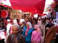 Market in Hotan
 -
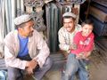 Uyghur people at Sunday market
 -
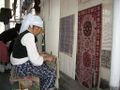 Carpet weaving in Hotan
 -
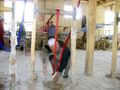 Silk weaving in Hotan
 -
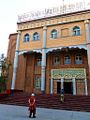 Entrance to the Hotan Cultural Museum
 -
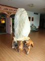 Local jade displayed in the Hotan Cultural Museum lobby.


See also
Notes
- ^ النسخ الحرفي الرسمي بحروف لاتينية (ولذلك، فهو التهجي في الإنگليزية) لإسم المدينة هو "Hotan" حسب Register of Chinese Geographic Places (中国地名录, published in Beijing, SinoMaps Press 中国地图出版社 1997; ISBN 7-5031-1718-4; p. 312.)؛ رومنة پنين خىتيان Hetian هو أيضاً اسم مستخدم في بعض الخرائط والمطارات؛ the city's former name was written with a different character for "Tian" (الصينية المبسطة: 阗; الصينية التقليدية: 闐; پنين: Tián)؛ المدينة أحياناً تُكتـَب هوتان Hotan، كما في هذا المثال. كما تُدعى يوتيان Yutian بالصينية وكانت تُعرف للمستكشفين الأوروپيين في القرن التاسع عشر بإسم إلچي Ilchi.
References
- ^ "和田市概况". Hotan Government Statistics. June 17, 2013. Archived from the original on November 29, 2014.
{{cite news}}: Unknown parameter|deadurl=ignored (|url-status=suggested) (help) - ^ Marc Aurel Stein. (1907) Ancient Khotan: Detailed Report of Archaeological Explorations in Eastern Turkestan. Oxford. Pages 123-126.
- ^ Bonavia, Judy. The Silk Road: Xi'an to Kashgar. Revised by Christopher Baumer (2004), pp. 306-319. Odyssey Publications. ISBN 962-217-741-7.
- ^ India and China: Interactions through Buddhism and Diplomacy: A Collection of Essays by Professor Prabodh Chandra Bagchi, Anthem Press, 1 October 2011, p. 186, ISBN 978-0-85728-821-9, https://books.google.com/books?id=hrA1DgAAQBAJ&pg=PA186
- ^ Puri, Baij Nath (1987), Buddhism in Central Asia, Motilal Banarsidass, pp. 52, ISBN 978-81-208-0372-5, https://books.google.com/books?id=sluKZfTrr3oC&pg=PA52
- ^ Latham, Ronald (1958). Marco Polo: the travels. p. 80.
- ^ Wood, Frances (2002). The Silk Road: two thousand years in the heart of Asia. p. 18.
- ^ Stein, Aurel M. (1907). "Ancient Khotan: Detailed report of archaeological explorations in Chinese Turkestan, 2 vols., p. 180. Clarendon Press. Oxford".
- ^ Bonavia, Judy. The Silk Road: Xi'an to Kashgar. Revised by Christopher Baumer (2004), p. 309. Odyssey Publications. ISBN 962-217-741-7.
- ^ 中国地面国际交换站气候标准值月值数据集(1971-2000年) (in Chinese). China Meteorological Administration. Archived from the original on 2013-09-21. Retrieved 2010-05-04.
{{cite web}}: Unknown parameter|deadurl=ignored (|url-status=suggested) (help)CS1 maint: unrecognized language (link) - ^ Stanley W. Toops (15 March 2004). "The Demography of Xinjiang". In S. Frederick Starr (ed.). Xinjiang: China's Muslim Borderland. Routledge. pp. 256–257. ISBN 978-0765613189.
- ^ "HÉTIÁN SHÌ (County-level City)". City Population.
- ^ Harper et al (2009), p. 840.
- ^ Bonavia, Judy. The Silk Road: Xi'an to Kashgar. Revised by Christopher Baumer (2004), pp. 307-308. Odyssey Publications. ISBN 962-217-741-7.
- ^ Marc Aurel Stein. (1907) Ancient Khotan: Detailed Report of Archaeological Explorations in Eastern Turkestan. Oxford. Pages 132-133.
- ^ Laufer, Berthold. Jade: A Study in Chinese Archaeology & Religion. (1912) Reprint: Dover Publications, New York, N.Y. (1974), pp. 24, 26, 291-293, 324. ISBN 0-486-23123-2.
- ^ A Biography of the Tripiṭaka Master of the great Ci'en Monastery of the Great Tang Dynasty. Śramaṇa Huili and Shi Yancong. Translated by Li Rongxi. Numata Center for Buddhist Translation and Research. (1995), p. 163. ISBN 1-886439-00-1.
== المراجع ==*Harper, Damian et al. (2009). Lonely Planet China: 11th Edition. Lonely Planet. ISBN 978-1-74104-866-7.
- Hill, John E. (1988). "Notes on the Dating of Khotanese History". Indo-Iranian Journal. 31: 179–190. doi:10.1163/000000088790083016. Updated version of this article is available for free download (with registration) at: independent.academia.edu
- Hulsewé, A. F. P. (1979). China in Central Asia: The Early Stage 125 BC − AD 23: an annotated translation of chapters 61 and 96 of the History of the Former Han Dynasty. E. J. Brill, Leiden. ISBN 90-04-05884-2.
- Legge, James 1886. A Record of Buddhistic Kingdoms: Being an account by the Chinese Monk Fa-Hien of his travels in India and Ceylon (A.D. 399-414) in search of the Buddhist Books of Discipline. Oxford, Clarendon Press. Reprint: New York, Paragon Book Reprint Corp. 1965.
- Mallory, J. P. and Mair, Victor H. 2000. The Tarim Mummies: Ancient China and the Mystery of the Earliest Peoples from the West. Thames & Hudson. London. 2000.
- Montell, Gösta, Sven Hedin’s Archaeological Collections from Khotan: Terra-cottas from Yotkan and Dandan-Uiliq, The Bulletin of the Museum of Far Eastern Antiquities 7 (1936), pp. 145–221.
- Montell, Gösta, Sven Hedin’s Archaeological Collections from Khotan II (appendix by Helmer Smith (pp. 101–102)), The Bulletin of the Museum of Far Eastern Antiquities 10 (1938), pp. 83–113.
- Puri, B. N. Buddhism in Central Asia, Motilal Banarsidass Publishers Private Limited, Delhi, 1987. (2000 reprint).
- Stein, Aurel M. 1907. Ancient Khotan: Detailed report of archaeological explorations in Chinese Turkestan, 2 vols. Clarendon Press. Oxford. dsr.nii.ac.jp 1907. Ancient Khotan: Detailed report of archaeological explorations in Chinese Turkestan, 2 vols. Clarendon Press. Oxford.[1] Ancient Khotan : vol.1 Ancient Khotan : vol.2
- Stein, Aurel M. 1921. Serindia: Detailed report of explorations in Central Asia and westernmost China, 5 vols. London & Oxford. Clarendon Press. Reprint: Delhi. Motilal Banarsidass. 1980. dsr.nii.ac.jp
- 1904 Sand-Buried Ruins of Khotan, London, Hurst and Blackett, Ltd. Reprint Asian Educational Services, New Delhi, Madras, 2000 Sand-Buried Ruins of Khotan : vol.1
- Watters, Thomas 1904–1905. On Yuan Chwang’s Travels in India. London. Royal Asiatic Society. Reprint: Delhi. Mushiram Manoharlal. 1973.
- Yu, Taishan. 2004. A History of the Relationships between the Western and Eastern Han, Wei, Jin, Northern and Southern Dynasties and the Western Regions. Sino-Platonic Papers No. 131 March 2004. Dept. of East Asian Languages and Civilizations, University of Pennsylvania.
وصلات خارجية
- Official government site (in Chinese)
- Silk Road Seattle - University of Washington (The Silk Road Seattle website contains many useful resources including a number of full-text historical works)
- Site devoted to the Buddhism of Khotan with a copy of Sir Aurel Stein's map of the Tarim Basin and Khotan region
- Satellite image of region which can be enlarged
- China: Taklamakan - Desert With No Ocean Underground
- "Khotan", Encyclopaedia Iranica [1]
- ^ M. A. Stein – Digital Archive of Toyo Bunko Rare Books at dsr.nii.ac.jp
- Pages using gadget WikiMiniAtlas
- Articles containing صينية-language text
- مقالات تحتوي نصوصاً باللغة الصينية المبسطة
- مقالات تحتوي نصوصاً باللغة الصينية التقليدية
- CS1 errors: unsupported parameter
- CS1 uses الصينية-language script (zh)
- Articles with hatnote templates targeting a nonexistent page
- Short description is different from Wikidata
- Articles containing Uyghur-language text
- Coordinates on Wikidata
- أماكن مأهولة على طريق الحرير
- أماكن مأهولة في شينجيانگ
- ممالك بوذية في آسيا الوسطى
- الشعوب القديمة في الصين
- بلدان سابقة في التاريخ الصيني
- واحات الصين
- Hotan Prefecture
- Uyghurs
- Hotan