غولجا
غولجا
伊宁市 (ييننگ)• غۇلجا شەھىرى • قۇلجا قالاسى (بالصينية) • (بالأويغورية) • (بالقزاقية) | |
|---|---|
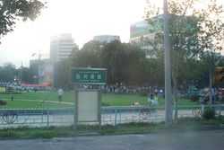
 الميدان الرئيسي لبلدة غولجا في يوليو 2005 | |
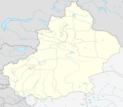
| الإحداثيات: 43°55′N 81°19′E / 43.917°N 81.317°E | |
| Country | People's Republic of China |
| Region | شينجيانگ |
| محافظة ذاتية | Ili (Kazakh) |
| المساحة | |
| • الإجمالي | 629 كم² (243 ميل²) |
| التعداد (2015)[1] | |
| • الإجمالي | 542٬507 |
| • الكثافة | 860/km2 (2٬200/sq mi) |
| منطقة التوقيت | UTC+8 (China Standard[أ]) |
| Postal code | 835000 |
| مفتاح الهاتف | 0999 |
| الموقع الإلكتروني | Official website |
| غولجا | |||||||||
|---|---|---|---|---|---|---|---|---|---|
| Chinese name | |||||||||
| الصينية المبسطة | 伊宁 | ||||||||
| الصينية التقليدية | 伊寧 | ||||||||
| |||||||||
| الاسم الصيني البديل | |||||||||
| الصينية | 固勒扎 | ||||||||
| |||||||||
| Uyghur name | |||||||||
| Uyghur | غۇلجا | ||||||||
| |||||||||
ييننگ (الصينية: 伊宁؛ إنگليزية: Yining)، وتُعرف أيضاً بإسم غولجا (ويغور: غۇلجا؛ بالقزاقية: قۇلجا، Құлжа)؛[ب] وسابقاً Ningyuan (寧遠) هي مدينة بمستوى ناحية في شمال غرب شينجيانگ، جمهورية الصين الشعبية، ومقر Ili Kazakh Autonomous Prefecture. وتاريخياً، كانت غولجا خليفة المدينة المهجورة Almaliq في Huocheng County المجاورة.
الجغرافيا
| ييننگ (غولجا) | ||||||||||||||||||||||||||||||||||||||||||||||||||||||||||||
|---|---|---|---|---|---|---|---|---|---|---|---|---|---|---|---|---|---|---|---|---|---|---|---|---|---|---|---|---|---|---|---|---|---|---|---|---|---|---|---|---|---|---|---|---|---|---|---|---|---|---|---|---|---|---|---|---|---|---|---|---|
| جدول طقس (التفسير) | ||||||||||||||||||||||||||||||||||||||||||||||||||||||||||||
| ||||||||||||||||||||||||||||||||||||||||||||||||||||||||||||
| ||||||||||||||||||||||||||||||||||||||||||||||||||||||||||||
Yining is located on the northern side of the Ili River in the Dzungarian basin, about 70 km (43 mi) east of the border with Kazakhstan, and about 710 km (440 mi) west of Ürümqi. The Ili River valley is far wetter than most of Xinjiang and has rich grazing land.
The City of Yining borders on Huocheng County in the west and the Yining County in the east; across the river in the south is Qapqal Xibe Autonomous County.
المناخ
Yining (Gulja) has a semi-arid climate (Köppen BSk), without the strong variation in seasonal precipitation seen across most of China. Dry and sunny weather dominates year-round. Winters are cold, with a January average of −8.8 °C (16.2 °F). Yet the influence of the Dzungarian Altau to the northwest and Boroboro Mountains to the northeast helps keep the city warmer than more easterly locales on a similar latitude. Summers are hot, with a July average of 23.1 °C (73.6 °F). Diurnal temperature ranges tend to be large from April to October. The annual mean temperature is 8.98 °C (48.2 °F). With monthly percent possible sunshine ranging from 53% in December to 73% in August and September, sunshine is abundant and the city receives 2,834 hours of bright sunshine annually.
| بيانات المناخ لـ غولجا (ييننگ) (1971–2000) | |||||||||||||
|---|---|---|---|---|---|---|---|---|---|---|---|---|---|
| الشهر | ينا | فب | مار | أبر | ماي | يون | يول | أغس | سبت | أكت | نوف | ديس | السنة |
| متوسط القصوى اليومية °س (°ف) | −2.1 (28.2) |
0.2 (32.4) |
9.0 (48.2) |
20.4 (68.7) |
24.8 (76.6) |
28.5 (83.3) |
31.0 (87.8) |
30.4 (86.7) |
25.8 (78.4) |
18.0 (64.4) |
8.7 (47.7) |
1.3 (34.3) |
16.3 (61.4) |
| متوسط الدنيا اليومية °س (°ف) | −15 (5) |
−12.2 (10.0) |
−2.5 (27.5) |
5.8 (42.4) |
10.2 (50.4) |
14.0 (57.2) |
15.8 (60.4) |
14.1 (57.4) |
9.3 (48.7) |
2.9 (37.2) |
−2.8 (27.0) |
−9.5 (14.9) |
2.5 (36.5) |
| متوسط تساقط الأمطار mm (inches) | 17.9 (0.70) |
19.1 (0.75) |
20.2 (0.80) |
28.0 (1.10) |
27.2 (1.07) |
28.5 (1.12) |
20.2 (0.80) |
14.2 (0.56) |
14.6 (0.57) |
26.1 (1.03) |
27.8 (1.09) |
25.0 (0.98) |
268.8 (10.57) |
| Average precipitation days (≥ 0.1 mm) | 8.1 | 7.6 | 8.1 | 7.6 | 8.6 | 9.1 | 8.1 | 6.2 | 4.4 | 6.7 | 7.4 | 8.3 | 90.2 |
| متوسط الرطوبة النسبية (%) | 78 | 78 | 70 | 55 | 58 | 59 | 56 | 54 | 57 | 66 | 74 | 78 | 65 |
| Mean monthly ساعات سطوع الشمس | 159.7 | 170.9 | 213.8 | 252.2 | 291.5 | 299.6 | 327.4 | 316.0 | 274.8 | 213.8 | 168.6 | 145.7 | 2٬834 |
| نسبة السطوع المحتمل للشمس | 56 | 58 | 58 | 63 | 64 | 65 | 70 | 73 | 73 | 68 | 58 | 53 | 64 |
| Source: China Meteorological Administration [2] | |||||||||||||
الاقتصاد
انظر أيضاً
ملاحظات
الهامش
- ^ "National Data". Retrieved 20 April 2016.
- ^ أ ب "中国地面国际交换站气候标准值月值数据集(1971-2000年)". China Meteorological Administration. Retrieved 2010-05-23.
وصلات خارجية
| Yining
]].- Yining City Government (صينية)
- Map of the City of Yining (Borders shown as they were before the annexation of the villages of Dadamutu (达达木图乡 on the map) and Panjin (潘津村 on the map) in 2004) (صينية)
- Pages using gadget WikiMiniAtlas
- Short description is different from Wikidata
- Articles containing صينية-language text
- Articles containing Uyghur-language text
- Articles containing قزخ-language text
- Coordinates on Wikidata
- Official website different in Wikidata and Wikipedia
- Articles containing simplified Chinese-language text
- Articles containing إنگليزية-language text
- Pages using Lang-xx templates
- Articles containing traditional Chinese-language text
- أماكن مأهولة في شينجيانگ
- أماكن مأهولة على طريق الحرير
