محافظة خوتان
محافظة خوتان
خوتەن ۋىلايىتى 和田地区 خوتان، خـِتيان، خوتين Hotan Prefecture | |
|---|---|
 مدينة خوتان | |
 محافظة خوتان (بالأحمر) (وتشمل كونيو في شينجيانگ (بالبرتقالي) | |
| البلد | جمهورية الصين الشعبية |
| المنطقة | شينجيانگ |
| المركز | خوتان[1] |
| Government | |
| • سكرتير الحزب الشيوعي الصيني (地委书记) | يانگ فاسن (杨发森[2]) |
| Area | |
• Total | 247٬800 كم² (95٬700 ميل²) |
| Population | |
• Total | 2٬014٬362 |
| • Density | 8٫1/km2 (21/sq mi) |
| Time zone | UTC+8 (توقيت الصين) |
| ISO 3166 code | CN-XJ-32 |
| Website | xjht |
| محافظة خوتان | |||||||||||
|---|---|---|---|---|---|---|---|---|---|---|---|
| Uyghur name | |||||||||||
| Uyghur | خوتەن ۋىلايىتى | ||||||||||
| |||||||||||
| Chinese name | |||||||||||
| الصينية المبسطة | 和田地区 | ||||||||||
| الصينية التقليدية | 和田地區 | ||||||||||
| |||||||||||
محافظة خوتان[5][6] (أو خوتان، خـِتيان، خوتين)، هي إحدى محافظات الصين وتقع في منطقة دزونگاريا في المنطقة الجنوبية الغربية من منطقة شينجيانگ ذاتية الحكم، الصين. تحدها من الجنوب لمنطقة التبت ذاتية الحكم، ومن الغرب إقليم لادخ الاتحادي. الغالبية العظمى من منطقة آقصاي چن متنازع عليها بين الصين والهند تدار كجزء من محافظة خوتان. مركز المحافظة هي مدينة خوتان وأكبر نواحيها حسب السكان هي ناحية قرة قاش. معظم سكان المحافظة من الأويغور المسلمين ويعيشون حول واحات تقع بين صحراء تكلامكان النائية وجبال كونلون.
كانت المنطقة جزءاً من مملكة خوتان البوذية الإيرانية. لاحقاً، كانت جزءاً من قرةخانات، ثم قرة خيتاي، خانية چاگاطاي، مغولستان وخانية زونگار، والتي اجتاحتها أسرة تشينگ الصينية. أصبحت خوتان جزءاً من شينجيانگ تحت حكم تشينگ.[7] في ثلاثينيات القرن العشرين، أعلنت إمارة خوتان استقلالها عن الصين. دخل جيش التحرير الشعبي خوتان عام 1949.
تشتهر المحافظة باليشم والحرير والسجاد.
التسمية
سُميت المحافظة على اسم مركزها، خوتان (خوتان، خـِتيان، خوتين).
التاريخ
لعبت منطقة محافظة خوتان دوراً رئيسياً في ثورة دونگان (1862–1877).[7]
في 22 ديسمبر 1949، وصلت قوات جيش التحرير الشعبي خوتان. عام 1950، أُعيد تنظيم المنطقة باسم مديرية خوتان (和闐專區).[8]
عام 1959، تغير اسم الحرف الصيني من '和阗' إلى نُطق آخر '和田'.[8]
عام 1962، وقعت أحداث الحرب الهندية الصينية في مناطق من آقصاي چن الواقعة تحت ادارة محافظة خوتان.
عام 1971، تغيرت خوتان من مديرية (专区) إلى محافظة (地区).[8]
حسب مراسل من ون وي پو في أورومچي، أن بين يناير وأغسطس 2005، أوقفت السلطات ستة مدارس دينية "غير قانونية-سرية" في محافظة خوتان وصادرت أكثر من مائة كتاب ودورية دينية غير مصرح لها بالإضافة إلى 972 شريط صوتي وڤيديو.[9][10]
عام 2016، تأسست كونيو داخل حدود محافظة خوتان.
التقسيمات الادارية


تنقسم محافظة خوتان إلى مدينة بمستوى مديرية وسبعة مديريات وكونيو المجاورة:[11][2]
 (خريطة غير مُحدثة: تأسست كونيو داخل حدود المحافظة عام 2016) | |||||||||
| # | الاسم | بالأويغورية (UEY) | Uyghur Latin (ULY) | بالصينية (م) | بالپنينية | السكان (2010) | المساحة (كم²) | الكثافة(/كم²) | |
|---|---|---|---|---|---|---|---|---|---|
| 1 | خوتان[12] (Hetian) | خوتەن شەھىرى | Hoten Shehiri | 和田市 | Hétián Shì | 322.300 | 466 | 691.63 | |
| 2 | ناحية خوتان[12] (خـِتيان) | خوتەن ناھىيىسى | Hoten Nahiyisi | 和田县 | Hétián Xiàn | 269.941 | 41.403[ب] | 6.51 | |
| 3 | ناحية مويو[12] (قرة قاش) | قاراقاش ناھىيىسى | Qaraqash Nahiyisi | 墨玉县 | Mòyù Xiàn | 500.114 | 25.789 | 19.39 | |
| 4 | ناحية پيشان[12] (پما) | گۇما ناھىيىسى | Guma Nahiyisi | 皮山县 | Píshān Xiàn | 258.210 | 39.742 | 6.49 | |
| 5 | ناحية لوپ (لووپو) | لوپ ناھىيىسى | Lop Nahiyisi | 洛浦县 | Luòpǔ Xiàn | 232.916 | 14.314 | 16.27 | |
| 6 | ناحية چيرا (تشيا، Cele) | چىرا ناھىيىسى | Chira Nahiyisi | 策勒县 | Cèlè Xiàn | 147.050 | 31.688 | 4.64 | |
| 7 | ناحية يوتيان[12] (كريا) | كېرىيە ناھىيىسى | Kériye Nahiyisi | 于田县 | Yútián Xiàn | 249.899 | 39.095 | 6.39 | |
| 8 | ناحية مينفنگ[12] (نييا) | نىيە ناھىيىسى | Niye Nahiyisi | 民丰县 | Mínfēng Xiàn | 33.932 | 56.760 | 0.59 | |

الجغرافيا
يعيش الغالبية العظمى من سكان المحافظة حول الواحات الواقعة بين صحراء صحراء تكلامكان النائية وجبال كونلون. إلى الشمال، تحدها محافظة آقسو، وإلى الشرق محافظة بيانبولاق الذاتية المنغولية، وإلى الغرب محافظة قشغر، وإلى الجنوب التبت، والمناطق المتنازع عليها بين الصين والهند وپكستان. تضم آقصاي چن أقصى نقطة جنوباً كجزء من شينجيانگ.
الديموغرافيا
| السنة | تعداد | ±% p.a. |
|---|---|---|
| 2000 | 1٬681٬310 | — |
| 2010 | 2٬014٬362 | +1.82% |
| [4] | ||
حسب تحليل أدريان زنز، فقد انخفض النمو السكاني لخوتان بشكل كبير ما بين 2015 و2018.[13]
اعتباراً من عقد 2000، كان الأويغور يشكلون أكثر من 95% من سكان محافظة خوتان.[4][14][15]
عام 2014، تبعاً لأحد الموظفين الحكوميين في بلدية لانگرو في ناحية خوتان، فإن "المعتقدات الإسلامية قوية للغاية" في المحافظة.[14]
يستخدم سكان محافظة خوتان اللغة الأويغورية ولا يتحدثون غالباً الصينية المندرينية.[6][15][16][17][18][مطلوب مصدر أفضل]
شخصيات بارزة
- إسماعيل أمات، رئيس (حاكم) شينجيانگ السابق.
- إسماعيل أخون، con-man
- ألباجان عوض أيوب، مغني پوپ، وكاتب أغاني وراقص
- قربان تولوم، روج له الحزب الشيوعي الصيني كرمزاً للوحدة مع الأويغور
خرائط تاريخية
خرائط تاريخية باللغة الإنگليزية لمحافظة خوتان:
-
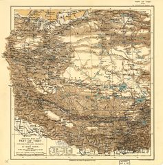 Map of the expeditions of Sven Hedin (1906-8) including the southern part of the modern Hotan Prefecture (RGS, early 20th century)
 -
![Map including most of northern Hotan Prefecture area (USATC, 1971)[ت]](/w/images/thumb/0/00/Txu-oclc-6654394-nj-44-3rd-ed.jpg/220px-Txu-oclc-6654394-nj-44-3rd-ed.jpg)
-
![From the Operational Navigation Chart; map including Hotan Prefecture area (DMA, 1980)[ث]](/w/images/thumb/f/fb/Operational_Navigation_Chart_G-7%2C_6th_edition.jpg/331px-Operational_Navigation_Chart_G-7%2C_6th_edition.jpg)
-
![Map including Hotan Prefecture area (northwest) (DMA, 1984)[ج]](/w/images/thumb/a/a1/Txu-pclmaps-oclc-22834566_g-7a.jpg/335px-Txu-pclmaps-oclc-22834566_g-7a.jpg)
-
![Map including Hotan Prefecture area (northeast) (DMA, 1990)[ح]](/w/images/thumb/2/26/Txu-pclmaps-oclc-22834566_g-7b.jpg/321px-Txu-pclmaps-oclc-22834566_g-7b.jpg)
-
![Map including Hotan Prefecture area (southwest) with Aksai Chin (DMA, 1995)[خ]](/w/images/thumb/e/ee/Txu-pclmaps-oclc-22834566_g-7d.jpg/318px-Txu-pclmaps-oclc-22834566_g-7d.jpg)

![Map including most of northern Hotan Prefecture area (USATC, 1971)[ت]](/w/index.php?title=%D9%85%D9%84%D9%81:Txu-oclc-6654394-nj-44-3rd-ed.jpg&filetimestamp=20200217181317&)
![From the Operational Navigation Chart; map including Hotan Prefecture area (DMA, 1980)[ث]](/w/index.php?title=%D9%85%D9%84%D9%81:Operational_Navigation_Chart_G-7,_6th_edition.jpg&filetimestamp=20200217183010&)
![Map including Hotan Prefecture area (northwest) (DMA, 1984)[ج]](/w/index.php?title=%D9%85%D9%84%D9%81:Txu-pclmaps-oclc-22834566_g-7a.jpg&filetimestamp=20200217183008&)
![Map including Hotan Prefecture area (northeast) (DMA, 1990)[ح]](/w/index.php?title=%D9%85%D9%84%D9%81:Txu-pclmaps-oclc-22834566_g-7b.jpg&filetimestamp=20200217183006&)
![Map including Hotan Prefecture area (southwest) with Aksai Chin (DMA, 1995)[خ]](/w/index.php?title=%D9%85%D9%84%D9%81:Txu-pclmaps-oclc-22834566_g-7d.jpg&filetimestamp=20200217183004&)
معرض صور
-
 سوق الحدادين
 -
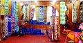 محل حرير
 -
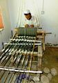
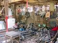 صناعة أجزاء الماكينات
 -
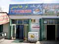 مقهى إنترنت
 -
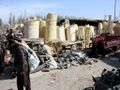
 صناعة قطع الأشجار
 -
 صناعات يدوية
 -
 سوق الحصائر
 -
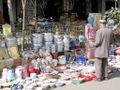
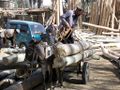
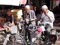 باعة جائلون


ملاحظات
- ^ includes areas in Aksai Chin
- ^ includes areas in Aksai Chin
- ^ From map: "DELINEATION OF INTERNATIONAL BOUNDARIES MUST NOT BE CONSIDERED AUTHORITATIVE".
- ^ From map: "The representation of international boundaries is not necessarily authoritative."
- ^ From map: "The representation of international boundaries is not necessarily authoritative"
- ^ From map: "The representation of boundaries is not necessarily authoritative."
- ^ From map: "The representation of boundaries is not necessarily authoritative."
الهامش
- ^ 夏征农; 陈至立, eds. (September 2009). 辞海:第六版彩图本 [Cihai (Sixth Edition in Color)] (in الصينية). 上海. Shanghai: 上海辞书出版社. Shanghai Lexicographical Publishing House. p. 0866. ISBN 9787532628599.
和田 1市名。{...}和田地区行署驻此。
- ^ أ ب 行政区划 [Administrative Divisions]. خوتەن 和田政府网. 19 January 2018. Retrieved 23 January 2020.
和田地区辖和田市、和田县、皮山县、墨玉县、洛浦县、策勒县、于田县、民丰县7县1市,91个乡镇,13个街道办事处,98个社区,1384个行政村,还有生产建设兵团十四师及所属奴尔牧场、47团场、皮山农场及224团场。历任中共和田地委书记22位,专员14位,现任地委书记杨发森、行署专员艾则孜•木沙。
- ^ 地貌气候 [Topography and Climate]. خوتەن 和田政府网 (in الصينية المبسطة). 15 November 2017. Retrieved 21 January 2020.
和田地区位于新疆维吾尔自治区最南端。{...}总面积24.78万平方公里。
- ^ أ ب ت ث 和田地区历史沿革 [Hotan Prefecture Historical Evolution]. XZQH.org (in الصينية المبسطة). 1 December 2014. Retrieved 21 January 2020.
2000年第五次人口普查,和田地区常住总人口1681310人。{...}2000年末,和田地区常住总人口168.15万,其中非农业人口23.67万人,占总人口的14.08%;维吾尔族162.56万人,占总人口的96.67%。{...}2003年,和田地区总面积248945.29平方千米,{...}2010年第六次人口普查,和田地区常住总人口2014362人,
- ^ The official spelling is "Hotan" according to Zhōngguó dìmínglù 中国地名录 (Beijing, SinoMaps Press 中国地图出版社 1997)، ISBN 7-5031-1718-4; p. 304.
- ^ أ ب Tao Yuan (陶源) (3 January 2020). "A closer look at Uygur students in boarding schools" (in الإنجليزية, الأويغورية, and الصينية). China Global Television Network. Event occurs at 0:42, 1:58, 2:05, 3:35. Retrieved 24 January 2020 – via YouTube.
Student, Moyu County Beijing Middle School
墨玉縣北京高級中學學生{...}
胡木旦村{...}
No other family member speaks Mandarin Chinese,
凱麥爾妮薩的家人都不會講國家通用語言{...}
Tao Yuan, CGTN, Hotan, Xinjiang.
CGTN 陶源 新疆和田 - ^ أ ب "Hotan". Encyclopædia Britannica. Retrieved 24 January 2020.
- ^ أ ب ت 历史沿革. خوتەن 和田政府网 (in الصينية المبسطة). 19 January 2019. Retrieved 22 January 2020.
1949年12月22日中国人民解放军十五团抵达和阗 ,和阗解放。1950年改称和阗专区,1959年改和阗为和田,1971年改专区为地区,1979年建立和田行政公署。
- ^ [2005-08-31] 新疆破獲東突分裂組織. Wen Wei Po (in الصينية التقليدية). 31 August 2005. Archived from the original on 7 November 2005 – via Internet Archive.
據悉,今年以來,該地區已查獲地下非法教經點6個,查收非法宗教書刊100餘本、音像製品972盒和帶有違法的各類物品1,874件。
- ^ "Uighur Separatists Arrested in Xinjiang's Hetian Prefecture". Congressional-Executive Commission on China. 7 September 2005. Retrieved 23 January 2020.
The article also reports that since January, Hetian authorities have disbanded six "illegal underground" religious schools and confiscated unauthorized religious books, periodicals, and audio and video tapes.
- ^ 2018年统计用区划代码和城乡划分代码:和田地区 [2018 Statistical Area Numbers and Rural-Urban Area Numbers: Hotan Prefecture] (in الصينية المبسطة). National Bureau of Statistics of the People's Republic of China. 2018. Retrieved 23 January 2020.
统计用区划代码 名称 653201000000 和田市 653221000000 和田县 653222000000 墨玉县 653223000000 皮山县 653224000000 洛浦县 653225000000 策勒县 653226000000 于田县 653227000000 民丰县
- ^ أ ب ت ث ج ح The official spelling according to Zhōngguó dìmínglù 中国地名录 (Beijing, SinoMaps Press 中国地图出版社 1997); ISBN 7-5031-1718-4
- ^ Adrian Zenz (24 November 2019). "China Didn't Want Us to Know. Now Its Own Files Are Doing the Talking". New York Times. Retrieved 24 December 2019.
Official statistics show that the combined net population growth rates of Hotan and Kashgar, two of the largest Uighur regions, dropped by about 84 percent between 2015 and 2018.
- ^ أ ب Richard Finney, Jelil Kashgari and Erkin Tarim (17 December 2014). "Uyghurs Face Seizure of Land, Personal Property Under Tough New Rules". Translated by Eset Sulaiman. Radio Free Asia. Retrieved 18 January 2020.
Government employees at the local level frequently regret the difficulties caused by these requirements, an employee at Langru's Economy Management Office told RFA, adding, "But we have no choice, since these are the rules of our county." Hotan prefecture, in which the county lies, "is a very special region in the [Xinjiang] Autonomous Region," he said. "Most of our population here are Uyghurs, and their Islamic beliefs are very strong."
- ^ أ ب "Invisible China : A Journey Through Ethnic Borderlands". Chicago Review Press. 2009. pp. 178, 181. ISBN 978-1-55652-814-9 – via Internet Archive.
While much of Xinjiang is being overpopulated by Han migration from eastern China that has more than quadrupled the desert region's population in a mere half-century, Hotan has been protected from the influx by its remote location at the southern base of the Taklimakan. It remains more than 95 percent Uyghur.{...}Even after eight years in the city, he spoke only Uyghur. His few Han clients were forced to communicate in their limited Uyghur, he explained, as he himself had never learned Chinese. In Hotan, there was no need for it.
{{cite web}}: Cite uses deprecated parameter|authors=(help) - ^ Peter Neville-Hadley (1997). China the Silk Routes. Cadogan Guides. Globe Pequot Press. p. 304. ISBN 1-86011-052-5 – via Internet Archive.
Travelling east from Khotan{...}Many Uighurs speak no Chinese at all, and most hotels are even less likely to have English speakers than those elsewhere in China.
- ^ David Eimer (2014). The Emperor Far Away: Travels at the Edge of China. Bloomsbury USA. p. 75. ISBN 978-1-62040-363-1 – via Internet Archive.
Far fewer people understood Mandarin in Hotan than anywhere else I'd been in Xinjiang. It made getting around difficult, as not only did the taxi drivers fail to understand what I was saying, but they couldn't read an address either. Most ignored or didn't know the Chinese names given to the streets anyway.
- ^ 王炜, ed. (2004). 新疆 [Xinjiang] (in الصينية المبسطة). Beijing: Encyclopedia of China Publishing House. pp. 235, 241. ISBN 7-5000-6883-2 – via Internet Archive.
和田地区{...}安全 因为与当地人语言交流可能有障碍,注意礼貌和当地习俗是非常必要,以免发生不必要的争执。
وصلات خارجية
- Articles containing صينية-language text
- CS1 uses الصينية-language script (zh)
- CS1 الصينية-language sources (zh)
- Articles containing Uyghur-language text
- CS1 الصينية المبسطة-language sources (zh-hans)
- CS1 الأويغورية-language sources (ug)
- CS1 الصينية التقليدية-language sources (zh-hant)
- CS1 errors: deprecated parameters
- Pages using gadget WikiMiniAtlas
- Short description is different from Wikidata
- Pages using infobox settlement with no coordinates
- كل المقالات بدون مراجع موثوقة
- كل المقالات بدون مراجع موثوقة from January 2020
- Articles with صينية-language sources (zh)
- Articles with Uyghur-language sources (ug)
- Coordinates on Wikidata
- محافظة خوتان