ديرنكويو
ديرنكويو
Derinkuyu | |
|---|---|
مدينة | |
| ديرنكويو | |
 بئر تهوية عميق في مدينة درنكويو تحت الأرض | |
 موقع ديرنكويو في تركيا. | |
 ديرنكويو | |
| Coordinates: 38°22′N 34°44′E / 38.367°N 34.733°E | |
| البلد | |
| المنطقة | وسط الأناضول |
| المحافظة | نڤشهر |
| Government | |
| • الحاكم | مراد دورو |
| • العمدة | أحمد بالجي (MHP) |
| Area | |
| • District | 444٫89 كم² (171٫77 ميل²) |
| Elevation | 1٬300 m (4٬300 ft) |
| Population (2012)[2] | |
| • Urban | 10٬804 |
| • District | 21٬945 |
| • District density | 49/km2 (130/sq mi) |
| Time zone | UTC+2 (ت.ش.أ.) |
| • Summer (DST) | UTC+3 (ت.ش.أ.ص.) |
| Postal code | 50xxx |
| Area code | 0384 |
| Licence plate | 50 |
| Climate | Csb |
| Website | www.derinkuyu.gov.tr |
ديرنكويو ("البئر العميق") (اليونانية القپادوقية: Μαλακοπή ؛ اللاتينية: Malakopí)، هي بلدة وقضاء في محافظة نڤشهر، منطقة وسط الأناضول، تركيا. حسب تعداد 2010، كان عدد سكان القضاء 22.114 يعيش منهم 10.679 نسمة في بلدة درنكويو.[3][4] يشغل القضاء مساحة 445 km2 (172 sq mi)،[5] وتقع على ارتفاع 1،300 m (4،265 ft)، حيث تقع أعلى نقطة عند جبل إرتاش على ارتفاع 1988 متر.
تشتهر البلدة بمدينتها المدفونة تحت الأرض (مدينة ديرنكيو تحت الأرض، والتي تعتبر من أهم المعالم الرئيسية. منطقة قپادوقيا، والتي تقع فيها درنكويو، تضم مدن تاريخية تحت الأرض، محفورة في تكوين جيولوجي فريد. تم اكتشاف ما يزيد عن 200 مدينة تحت الأرض على مستويين من العمق على الأقل في المنطقة الواقعة ما بين قيصرية ونڤشهر، وهناك 40 منهم تقريباً بثلاث مستويات. وتوجد المدينة بأكملها تحت الأرض وتم بناء المدينة على شكل مجموعة من المستويات مثل المدرجات على عمق كبير تحت الأرض، وقد كانت مخصصة هذه المدينة لتخزين الطعام والمواشي، وقد شيد المدينة خلال القرن السابع والثامن الميلادي من أجل الاحتماء من الغزوات التي كانت تتعرض لها تركيا.
التاريخ
The oldest written source about underground structures is the writings of Xenophon. In his Anabasis (circa 370 BCE), he writes that the people living in Anatolia had excavated their houses underground, living well in accommodations large enough for the family, domestic animals, and supplies of stored food.[6] The first two floors of the Derinkuyu Underground City have been dated to this early period.
From Byzantine times (4th century CE) through 1923 Derinkuyu was known by its Cappadocian Greek inhabitants as Malakopea (باليونانية: Μαλακοπέα).[7] The underground city was greatly expanded in the middle Byzantine period to serve as a refuge from the raids of the Umayyad Arab and Abbasid armies, during the Arab–Byzantine wars (780-1180). The city contained food stores, kitchens, stalls, churches, wine and oil presses, ventilation shafts, wells, and a religious school. The Derinkuyu underground city has at least eight levels and depth of 85 m and could have sheltered thousands of people. The city continued to be used as protection from the Mongolian incursions of Timur in the 14th century.[8][9] After the region fell to the Ottomans the cities were used as refuges (Greek: καταφύγια). As late as the 20th century the town's inhabitants, called Cappadocian Greeks, were still using the underground chambers to escape periodic waves of Ottoman persecution.[10] (The Cambridge linguist Dawkins, who spent time in the towns from 1910–1911 while writing his book on Cappadocian Greek wrote, "their use as places of refuge in time of danger is indicated by their name καταφύγια. In 1909, when the news came of the recent massacres at Adana, a great part of the population at Axo took refuge in these underground chambers, and for some nights did not venture to sleep above ground.[11] When the Cappadocian Greeks were required to leave in 1923 in the population exchange between Greece and Turkey, the tunnels were finally abandoned.[12][13]
معرض الصور
-
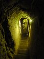 سلم في مدينة درنكويو تحت الأرض، قپادوقيا، تركيا.
 -
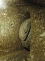 باب حجري دوار في مدينة درنكويو تحت الأرض، قپادوقيا، تركيا.
 -
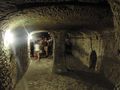 غرفة في مدينة درنكويو تحت الأرض، قپادوقيا، تركيا.


مرئيات
| ديرنكويو، هي مدينة قديمة تحت الأرض متعددة المستويات تقع بالقرب من مدينة ديرينكويو الحديثة في محافظة نڤشهر في تركيا، وتمتد إلى عمق 85 مترًا تقريبًا. وهي كبيرة بما يكفي لإيواء ما يصل إلى 20 ألف شخص مع مواشيهم ومخازن المواد الغذائية. |
انظر أيضاً
- Avanos
- Churches of Göreme, Turkey
- Eskigümüş Monastery
- Ihlara Valley
- Mokissos
- Özkonak Underground City
- Zelve Monastery
الهوامش
- ^ "Area of regions (including lakes), km²". Regional Statistics Database. Turkish Statistical Institute. 2002. Retrieved 2013-03-05.
- ^ "Population of province/district centers and towns/villages by districts - 2012". Address Based Population Registration System (ABPRS) Database. Turkish Statistical Institute. Retrieved 2013-02-27.
- ^ Statistical Institute[dead link]
- ^ GeoHive. "Statistical information on Turkey's administrative units". Retrieved 2008-04-14.
- ^ Statoids. "Statistical information on districts of Turkey". Retrieved 2008-04-14.
- ^ Xen. An. 4.5.24-7.
- ^ Peter Mackridge, "Some Pamphlets on Dead Greek Dialects': R.M. Dawkins and Modern Greek Dialectology", 1990. p. 205. "Anyone who attempts to find the Greek villages of Cappadocia today, either on the map or on the ground, is first faced by the problem that their names have been obliterated, a chauvinistic practice not only prevalent in modern Turkey, but practiced in Greece as well. Visitors to the so-called 'underground cities' at Kaymakli and Derinkuyu have difficulty in ascertaining that until 1923 they were called Anaku and Malakopi respectively (the latter being the Μαλακοπαία of Theophanes. Once located, however, these villages bear obvious traces of their Greek Christian past in the shape of sizable churches (some of which have been converted into mosques and are therefore well preserved, but with their frescoes covered with whitewash), and a number of rather elegant houses, whose Greekness is betrayed only by the initials and dates (usually about ten years before the 1923 exchange of populations."
- ^ Kinross, Baron Patrick Balfour (1970). Within the Taurus: a journey in Asiatic Turkey. J. Murray. p. 168. ISBN 978-0-7195-2038-9.
Its inhabitants were Cappadocian Greeks, who may have found a refuge here, perhaps from Roman, from Iconoclast, or later from Turkish and Mongol threats. Urgup itself was the Byzantine Prokopion; the Emperor Nicephoros Phocas is said to have passed this way, after his Cilician campaign; and the neighborhood was populous enough to support, at different times, a number of bishoprics.
- ^ Dawkins, R.M. (1916). Modern Greek in Asia Minor. A study of dialect of Silly, Cappadocia and Pharasa. Cambridge University Press. p. 17. Retrieved 25 October 2014.
these excavations are referred to as long ago as the campaigns of Timour Beg, one of whose captains was sent to hunt out the inhabitants of Kaisariyeh, who had taken refuge in their underground dwellings, and was killed by an arrow shot through the hole in one of the doors.
- ^ Dawkins, R.M. (1916). Modern Greek in Asia Minor. A study of dialect of Silly, Cappadocia and Pharasa. Cambridge University Press. p. 16. Retrieved 25 October 2014.
their use as places of refuge in time of danger is indicated by their name καταφύγια, and when the news came of the recent massacres at Adana [in 1909], a great part of the population at Axo took refuge in these underground chambers, and for some nights did not venture to sleep above ground.
- ^ Dawkins, R.M. (1916). Modern Greek in Asia Minor. A study of dialect of Silly, Cappadocia and Pharasa. Cambridge University Press. p. 16. Retrieved 25 October 2014.
- ^ Darke, Diana (2011). Eastern Turkey. Bradt Travel Guides. pp. 139–140. ISBN 978-1-84162-339-9.
The area became an important frontier province during the 7th century when Arab raids on the Byzantine Empire began. By now the soft tufa had been tunneled and chambered to provide underground cities where a settled if cautious life could continue during difficult times. When the Byzantines re-established secure control between the 7th and 11th centuries, the troglodyte population surfaced, now carving their churches into rock faces and cliffs in the Goreme and Sogamli areas, giving Cappadocia its fame today. […] At any rate here they flourished, their churches remarkable for being cut into the rock, but interesting especially for their paintings, relatively well preserved, rich in coloring, and with an emotional intensity lacking in the formalism of Constantinople; this is one of the few places where paintings from the pre-iconoclastic period have survived. Icons continued to be painted after the Seljuk conquest of the area in the 11th century, and the Ottoman conquest did not interfere with the Christian practices in Cappadocia, where the countryside remained largely Greek, with some Armenians. But decline set in and Goreme, Ihlara and Soganli lost their early importance. The Greeks finally ending their long history here with the mass exchange of populations between Turkey and Greece in 1923.
- ^ Rodley, Lyn (2010). Cave Monasteries of Byzantine Cappadocia. Cambridge University Press. p. 1. ISBN 978-0-521-15477-2.
The tenth-century historian Leo the Deacon records a journey to Cappadocia made by Nikephoros Phokas shortly before he became emperor. Perhaps to recapture the attention of readers beginning to tire of troop movements he also offers a scrap of information about a curiosity of the region to which the emperor was heading: its inhabitants were once called troglodytes, because 'they went underground in holes, clefts and labyrinths, as it were in dens and burrows'. This brief note was probably not based on first-hand knowledge but it might have been prompted by an awareness of the vast number of rock-cut cavities in an area to the west and southwest of Kaisareia (Kayseri of modern Turkey). Had Leo been more inclined to garrulous digression (or perhaps just better informed), he might have supplied more details of the troglodyte region and the task of bringing scholarly order to the hundreds of rock-cut monuments and other cavities in the area might have been much similar. … At this time the region was still inhabited by a mixed population of Turkish-speaking Moslems and Greek-speaking Christians. The latter group left for Greece in the early 1920s, during an exchange of population of minorities that was part of the radical social re-ordering initiated by Kemal Atatürk; they were replaced by Turks from Greece, mostly from Thrace. In the two decades before this upheaval, however, members of the local Greek population acted as guides to Guillaume de Jerphanion, who made several visits to the volcanic valleys and wrote his meticulous descriptions of many painted Byzantine rock-cut churches.
المصادر
- Falling Rain Genomics, Inc. "Geographical information on Derinkuyu, Turkey". Retrieved 2008-04-14.
- Governorship of Derinkuyu, Turkey. "General information on Derinkuyu, Nevşehir" (in Turkish). Archived from the original on 2008-06-30. Retrieved 2008-04-14.
{{cite web}}: Unknown parameter|deadurl=ignored (|url-status=suggested) (help)CS1 maint: unrecognized language (link)
وصلات خارجية
- District governor's official website (لغة تركية)
- District municipality's official website (لغة تركية)
| المقاطعات الحضرية | ||
|---|---|---|
| المقاطعات الريفية | ||
المناطق | ||
| إيجه | ||
| البحر الأسود | ||
| وسط الأناضول | ||
| شرق الأناضول | ||
| مرمرة | ||
| البحر المتوسط | ||
| جنوب شرق الأناضول | ||

- Articles with dead external links from December 2016
- Pages using gadget WikiMiniAtlas
- Short description is different from Wikidata
- Articles containing Greek-language text
- CS1 errors: unsupported parameter
- مقاطعات محافظة نڤشهر
- منطقة وسط الأناضول
- Coordinates on Wikidata
- بلدات تركيا
- قپادوقيا
- أماكن مأهولة في محافظة نڤشهر
- أقضية محافظة نڤشهر
- مقاطعة ديرنكويو