محافظة چيانگ راي
چيانگ راي
เชียงราย Chiang Rai | |
|---|---|
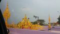
Left to right, top to bottom: King Mangrai Intersection, Chiang Rai Clock Tower, Wat Phra Kaew, Wat Phra Sing, Wat Rong Khun, Wat Rong Suea Ten, Doi Tung Royal Villa, Phu Chi Fa | |
 الشعار | |
 | |
| Coordinates: 19°54′N 99°49′E / 19.900°N 99.817°E | |
| العاصمة | چيانگ راي |
| Government | |
| • المحافظ | Sumet Saengnimnuan |
| Area | |
• Total | 11٬678 كم² (4٬509 ميل²) |
| Population (2014) | |
• Total | 1٬207٬699[1] |
| Human Development Index | |
| • HDI (2009) | 0.752 (high) (rank?) |
| Postal code | 57xxx |
| Calling code | 053 |
| Vehicle registration | เชียงราย |
| Accession into Kingdom of Thailand | 1910 |
| Accession into Kingdom of Thailand | 1932 |
| Website | http://www.chiangrai.go.th |
_-_img_03.jpg&filetimestamp=20240705164855&)


چيانگ راي (بالتايلندية: เชียงราย؛ تُنطق [t͡ɕʰīaŋ.rāːj]; تايلندية الشمالية: ᨩ᩠ᨿᨦᩁᩣ᩠ᨿ؛ تـُنطق [tɕiaŋ.haaj]؛ بالبورمية: ![]() ؛ إنگليزية: Chiang Rai) هي محافظة تقع في أقصى شمال تايلاند. تحدها محافظات فاياو، ولامبانگ وچيانگ ماي. ويحدها من الشمال ولاية شان في ميانمار ومحافظتا بوكيو و أودومشاي في لاوس.
؛ إنگليزية: Chiang Rai) هي محافظة تقع في أقصى شمال تايلاند. تحدها محافظات فاياو، ولامبانگ وچيانگ ماي. ويحدها من الشمال ولاية شان في ميانمار ومحافظتا بوكيو و أودومشاي في لاوس.
The provinces is linked to Houayxay Laos by the Fourth Thai–Lao Friendship Bridge that spans the Mekong.
| محافظة تشيانغ راي | |
|---|---|
 | |
| Thai name | |
| Thai | เชียงราย |
| RTGS | Chiang Rai |
| Northern Thai name | |
| Northern Thai | ᨩ᩠ᨿᨦᩁᩣ᩠ᨿ [tɕiaŋ.haːj] |
الجغرافيا
متوسط إرتفاع السطح 580 متر. شمال المحافظة يندرج تحت ما يطلق عليه المثلث الذهبي, والذي يغطي الحدود المشتركة بين تايلاند, لاوس و ميانمار -عرفت المنطقة بتوترها أمنيا حيث إنها منطقة تهريب المخدرات بين الحدود. ويقع في المحافظة أيضا نهر ميكونج الذي يجري بمحاذاة لاوس، ونهر ماي ساي. بينما يغطى الجزء الشرقي من المحافظة بلأنهار الجارية,يعرف الجزءالغربي بطبيعته الجبلية. بالرغم من أن هضبة العلم ذات ال 1322 متر لا تعد الأعلى لكن تعتبر الأشهر في المحافظة. كما يعود تاريخ معبد وات فرا ذات توي و الذي يقع على قمة الهضبة إلى عام 911.
The average elevation of the province is 580 متر (1،903 ft). The north of the province is part of the so-called Golden Triangle, where the borders of Thailand, Laos and Burma converge, an area which prior to the rise of agricultural production of coffee, pineapple, coconuts, and banana plantations, was unsafe because of drug smuggling across the borders. The Mekong River forms the boundary with Laos, the Mae Sai and Ruak River with Burma. Through the town of Chiang Rai itself, flows the "Mae Kok" Kok River and south of it the Lao River, a tributary of the Kok.
While the eastern part of the province is characterized by relatively flat river plains, the northern and western part consists of the hilly terrain of the Thai highlands with the Khun Tan Range and the Phi Pan Nam Range in the west and the Daen Lao Range in the north. While not the highest elevation of the province, the 1،389-متر (4،557 ft) high[2] Doi Tung (Flag Hill) is the most important terrain feature. Wat Phra That Doi Chom Thong wat on top of the hill, according to the chronicles, dates back to the year 911. Nearby is Doi Tung Royal Villa, former residence of the late princess mother Somdej Phra Srinagarindra (mother of King Rama IX). Thanks to her activities the hills were reforested, and the hill tribes diverted from growing opium poppies to other crops including coffee, bananas, coconuts, and pineapples. The total forest area is 4،585 km2 (1،770 sq mi) or 39.9 percent of provincial area.[3]
المنتزهات الوطنية
There are seven national parks, along with one other national park, make up region 15 of Thailand's protected areas.
- Doi Luang National Park, 1،169 km2 (451 sq mi)[4]
- Lam Nam Kok National Park, 587 km2 (227 sq mi)[5]
- Mae Puem National Park, 351 km2 (136 sq mi)[4]
- Phu Sang National Park, 285 km2 (110 sq mi)[4]
- Khun Chae National Park, 270 km2 (100 sq mi)[4]
- Phu Chi Fa National Park, 93 km2 (36 sq mi)[5]
- Tham Luang–Khun Nam Nang Non National Park, 19 km2 (7.3 sq mi)[5]
التاريخ
Chiang Rai was founded in 1262. Populations have dwelled in Chiang Rai since the 7th century and it became the center of the Lanna Kingdom during the 13th century. The region, rich in natural resources, was occupied by the Burmese until 1786.
Chiang Rai province's golden triangle bordering Laos and Burma was once the hub of opium production.
Chiang Rai became a province in 1910, after being part of the Lanna Kingdom for centuries. After Lanna was incorporated into Thailand, it remained an autonomous region and thus the Chiang Rai area was administered from Chiang Mai.
Chiang Rai province is a transit point for Rohingya refugees from Myanmar (Burma) who are transported there from Sangkhlaburi district in Kanchanaburi province.[6]
أصبحت شيانج ري محافظة عام 1910, بعد أن كانت جزء من مملكة لاناتاي لقرون.و بعد أن إنضمت لاناتاي إلى تايلاند, ظلت محافظة ذات حكم ذاتي وكانت تدار من محافظة شيانج مي.
 |
السكان
The majority of the population are ethnic Thai who speak Kham Muang among themselves, but 12.5% are of hill tribes origin, a sizeable minority in the north provinces. A smaller number are of Chinese descent, mainly descendants of the Kuomintang soldiers who settled in the region, notably in Santikhiri.
الجماعات العرقية

Khon Muang are the city folk who originally came from Chiang Mai, Lamphun, Lampang, and Phrae. Culturally, they design their houses having only one floor with wooden gable decorations called "ka-lae". They are known for their craftsmanship in wood carving, weaving, lacquer ware, and musical instruments.
Tai Yai (ไทใหญ่) (Shan) are a Tai ethnic group who primarily live in what is now Shan State in Burma, and also in Mae Hong Son province in Thailand. They grow rice, farm, raise cattle, and trade. Their craftsmanship lies in weaving, pottery, wood carving, and bronze ware.
Akha have the largest population of any hill tribe in the region. Originating from Tibet and southern China, they dwell on high ground around 1,200 meters above sea level. Within their villages they build spirit gateways to protect them from evil spirits.
Lahu (Musor) are also from the Yunnanese area and live in high areas. They are known as hunters and planters. Karen live in various areas of the region which have valleys and riverbanks.
Chin Haw in Chiang Rai consist primarily of the former Kuomintang (KMT army) who took refuge in the area, mainly in Santikhiri (formerly Mae Salong).
Hmong from southern China, inhabit high ground. They raise livestock and grow rice, corn, tobacco, and cabbage. They are also known for their embroidery and silver.
Tai Lue (Dai) live in dwellings of usually only a single room wooden house built on high poles. They are skilled in weaving.
Lisu from southern China and Tibet are renowned for their colorful dress and also build their dwellings on high stilts. They harvest rice and corn and their men are skilled in hunting.
Yao (Mien) reside along mountain sides and grow corn and other crops. They are skilled blacksmiths, silversmiths, and embroiders.

الدين
Religion in Chiang Rai
الشعارات


The seal of the province shows a white elephant, the royal symbol, recalling that Chiang Rai was founded by King Mengrai, according to legend because his elephant liked the place.
The provincial tree is the tree jasmine (Radermachera ignea), and the provincial flower is the orange trumpet (Pyrostegia venusta).
The former provincial slogan was "เหนือสุดในสยาม อร่ามดอยตุง ผดุงวัฒนธรรม รสล้ำข้าวสาร หอมหวานลิ้นจี่ สตรีโสภา ชาเลิศรส สัปปะรดนางแล", 'Northernmost of Siam, beautiful Doi Tung, repository of culture, most delicious rice, sweet and fragrant lychee, beautiful women, the finest flavoured tea, pineapple from Nang Lae, source of the giant catfish".
The current slogan is "เหนือสุดในสยาม ชายแดนสามแผ่นดิน ถิ่นวัฒนธรรมล้านนา ล้ำค่าพระธาตุดอยตุง", 'Northernmost of Siam, frontier of three lands, the home of Lan Na culture and Doi Tung Temple'.
المستشفيات
- Kasemrad Sriburin General Hospital, Private hospital.
- Chiangrai Prachanukroh Hospital, Public hospital.
السياحة
Chiang Rai is known for its beautiful landscapes, cultural heritage, and unique attractions. The city attracts a large number of tourists every year who come to explore its temples, markets, museums, and its natural beauty.[7]
One of the most popular attractions is the Wat Rong Khun,[8] Another attraction is the Golden Triangle, which is the meeting point of Thailand, Laos, and Myanmar and offers views of the Mekong River and the surrounding mountains. Other popular attractions in Chiang Rai include the Doi Tung Royal Villa, Baan Dam Museum, the Hill Tribe Museum and Education Center, and the Khun Korn Waterfall.[9]
Chiang Rai is also a popular base for exploring the surrounding areas, including the Mae Sai border town, the Chiang Saen historical city, and the Doi Mae Salong tea plantations.
Transport

Air
Chiang Rai International Airport has domestic flights to both Bangkok airports, which connect to regional and international flights.
Boat
There is daily boat service between Chiang Rai and Tha Ton.
Rail
There is no railway system in Chiang Rai. The nearest station is Chiang Mai Railway Station.
Road
Chiang Rai province is intersected by Asian Highway 2, which runs for over 13،000 كيلومتر (8،100 mi) from Denpasar in Indonesia to Kosravi in Iran, and by Asian Highway 3, which runs for over 7،000 km (4،300 mi) from Kentung in Myanmar to Ulan-Ude in Russia.
Decent bus services are available in the province. In more remote areas, songthaews are the norm.
التقسيمات الإدارية

Provincial government
Chiang Rai is divided into 18 districts (amphoes). The districts are further divided into 124 sub-districts (tambons) and 1,751 villages (mubans).
|
|
|
الحكم المحلي
As of 26 November 2019 there are:[10] one Chiang Rai Provincial Administration Organisation (ongkan borihan suan changwat) and 73 municipal (thesaban) areas in the province. Chiang Rai has city (thesaban nakhon) status. Further 72 subdistrict municipalities (thesaban tambon). The non-municipal areas are administered by 70 Subdistrict Administrative Organisations - SAO (ongkan borihan suan tambon).[11]
مؤشر الإنجاز البشري 2022
| الصحة | التعليم | التوظيف | الدخل |
| 61 | 71 | 53 | 19 |
| الإسكان | الأسرة | النقل | المشاركة |

|
 |

|
.png&filetimestamp=20200817024747&)
|
| 42 | 37 | 45 | 20 |
| Province Chiang Rai, with an HAI 2022 value of 0.6307 is "somewhat low", occupies place 52 in the ranking. | |||
Since 2003, United Nations Development Programme (UNDP) in Thailand has tracked progress on human development at sub-national level using the Human achievement index (HAI), a composite index covering all the eight key areas of human development. National Economic and Social Development Board (NESDB) has taken over this task since 2017.[12]
| Rank | Classification |
| 1–13 | "عالي" |
| 14–29 | "عالي قليلاً" |
| 30–45 | "متوسط" |
| 46–61 | "منخفض قليلاً" |
| 62–77 | "منخفض" |
| Map with provinces and HAI 2022 rankings |

|
المناخ
| بيانات المناخ لـ چيانگ راي (1981–2010) | |||||||||||||
|---|---|---|---|---|---|---|---|---|---|---|---|---|---|
| الشهر | ينا | فب | مار | أبر | ماي | يون | يول | أغس | سبت | أكت | نوف | ديس | السنة |
| متوسط القصوى اليومية °س (°ف) | 28.6 (83.5) |
31.3 (88.3) |
33.8 (92.8) |
34.8 (94.6) |
33.1 (91.6) |
32.1 (89.8) |
31.1 (88.0) |
30.9 (87.6) |
31.1 (88.0) |
30.5 (86.9) |
28.8 (83.8) |
27.2 (81.0) |
31.1 (88.0) |
| متوسط الدنيا اليومية °س (°ف) | 12.8 (55.0) |
13.7 (56.7) |
16.9 (62.4) |
20.6 (69.1) |
22.5 (72.5) |
23.6 (74.5) |
23.4 (74.1) |
23.3 (73.9) |
22.7 (72.9) |
21.1 (70.0) |
17.3 (63.1) |
13.5 (56.3) |
19.28 (66.70) |
| متوسط تساقط الأمطار mm (inches) | 7.5 (0.30) |
13.8 (0.54) |
28.2 (1.11) |
97.9 (3.85) |
213.4 (8.40) |
178.4 (7.02) |
310.9 (12.24) |
358.4 (14.11) |
283.9 (11.18) |
124.9 (4.92) |
59.2 (2.33) |
14.0 (0.55) |
1٬690٫5 (66.55) |
| Average rainy days (≥ 1 mm) | 2 | 1 | 3 | 10 | 17 | 19 | 22 | 24 | 18 | 12 | 6 | 3 | 137 |
| متوسط الرطوبة النسبية (%) | 75 | 67 | 62 | 66 | 76 | 80 | 82 | 84 | 83 | 82 | 79 | 77 | 76 |
| Source: Thai Meteorological Department (Normal 1981-2010), (Avg. rainy days 1961-1990) | |||||||||||||
التقسيمات الإدارية
تنقسم المحافظة إلى 16 منطقة إدارية و منطقتان خاصتان, و تنقسم المناطق إلى 125 منطقة أصغر و 1510 قرية.
- المناطق الإدارية: مويانج شيانج ري, ويانج شاي, شيانج كونج, ثوينج, فان,با دايت, ماي شان, شيانج ساين, ماي ساي, ماي سواي, ويانج با باو, فايا منجراي, ويانج كاين, كون تان, ماي فا لوانج,ماي لاو.
- المناطق الخاصة: ويانج شيانج رونج, دوي لوانج.

Chiang Rai is subdivided into 18 districts (amphoe). The districts are further subdivided into 124 subdistricts (tambon) and 1,751 villages (muban).
|
|
معرض صور
-

-
 Pu Kaeng Waterfall, Doi Luang National Park
 -
 Huai Mak Liam Hot Spring, Lam Nam Kok National Park
 -
 A road tunnel decorated with Thai style art
 -
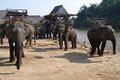 Elephants, Kok River
 -
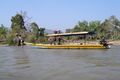 Kok River
 -
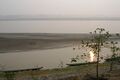 Chiang Saen, Mekong River
 -
 Chiang Saen


المصادر
- ^ "Population of the Kingdom" (PDF). Department of Provincial Affairs (DOPA) Thailand (in Thai). 2014-12-31. Retrieved 19 Mar 2015.
{{cite web}}: CS1 maint: unrecognized language (link) - ^ "Thailand - Mountains beginning with Doi Tung - Doi Tung to Doi Wiang Pha". www.indexmundi.com.
- ^ خطأ استشهاد: وسم
<ref>غير صحيح؛ لا نص تم توفيره للمراجع المسماةRFD - ^ أ ب ت ث "ข้อมูลพื้นที่อุทยานแห่งชาติ ที่ประกาศในราชกิจจานุบกษา 133 แห่ง" [National Park Area Information published in the 133 Government Gazettes]. Department of National Parks, Wildlife and Plant Conservation (in Thai). December 2020. Archived from the original on 3 November 2022. Retrieved 1 November 2022.
{{cite web}}: CS1 maint: unrecognized language (link) - ^ أ ب ت "ข้อมูลพื้นที่อุทยานแห่งชาติ (เตรียมการ) 22 แห่ง" [Information of 22 National Parks Areas (Preparation)]. Department of National Parks, Wildlife and Plant Conservation (in Thai). December 2020. Archived from the original on 3 November 2022. Retrieved 1 November 2022.
{{cite web}}: CS1 maint: unrecognized language (link) - ^ "Putrajaya's migrant deluge woes", The Star, Kuala Lumpur, Malaysia, 13 May 2015, http://www.thestar.com.my/News/Nation/2015/05/13/Putrajayas-migrant-deluge-woes-Emergency-meetings-held-to-find-solutions/
- ^ "The official website of Tourism Authority of Thailand". www.tourismthailand.org (in الإنجليزية). Retrieved 2023-05-10.
- ^ Barnes, Jo (2022-12-16). "Top 10 Very Best Things to Do in Chiang Rai, Thailand". Your Lifestyle Business (in الإنجليزية الأمريكية). Retrieved 2023-05-10.
- ^ Berger, Arthur Asa (2014-03-18). Thailand Tourism (in الإنجليزية). Routledge. ISBN 978-1-317-82478-7.
- ^ "Number of local government organizations by province". dla.go.th. Department of Local Administration (DLA). 26 November 2019. Retrieved 10 December 2019.
12 Chiang Rai: 1 PAO, 1 City mun., 72 Subdistrict mun., 70 SAO.
- ^ خطأ استشهاد: وسم
<ref>غير صحيح؛ لا نص تم توفيره للمراجع المسماةTDD - ^ خطأ استشهاد: وسم
<ref>غير صحيح؛ لا نص تم توفيره للمراجع المسماةHAI 2565
وصلات خارجية
 Chiang Rai travel guide from Wikivoyage
- Provincial Website (Thai)[dead link]
- Chiang Rai page from the Tourist Authority of Thailand
- English News Chiang Rai Province
أماكن قريبة من محافظة تشيانغ راي | ||||||||||
|---|---|---|---|---|---|---|---|---|---|---|
| ||||||||||

- CS1 الإنجليزية الأمريكية-language sources (en-us)
- Short description is different from Wikidata
- Pages using multiple image with auto scaled images
- Pages using gadget WikiMiniAtlas
- Pages using infobox settlement with missing country
- Articles containing تايلندية-language text
- Articles containing تايلندية الشمالية-language text
- Pages using Lang-xx templates
- Pages with تايلندية الشمالية IPA
- Articles containing بورمية-language text
- Articles containing إنگليزية-language text
- Articles with hatnote templates targeting a nonexistent page
- المقالات needing additional references from October 2013
- كل المقالات needing additional references
- Articles with dead external links from April 2015
- محافظات تايلند
- محافظة چيانگ راي
- أماكن مأهولة على نهر المكونگ