ويكو، تكساس
ويكو، تكساس
Waco, Texas | |
|---|---|
| City of Waco | |
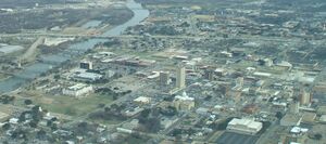
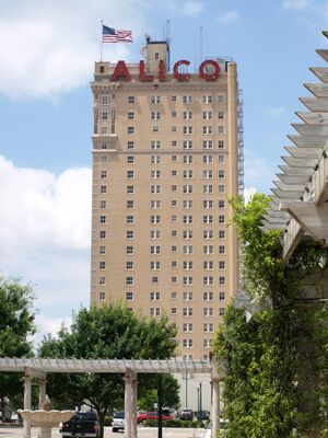
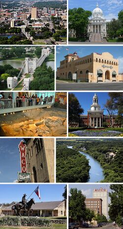 From left to right, top to bottom: Downtown, McLennan County Courthouse, Waco Suspension Bridge, Dr. Pepper Museum, Waco Mammoth National Monument, Baylor University, Waco Hippodrome, Cameron Park, Texas Ranger Hall of Fame and Museum, and Austin Avenue in Downtown | |
|
| |
| الكنية: "Heart of Texas" "Buckle of the Bible Belt"[1] | |
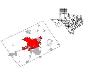 الموقع في مقاطعة مكلنن و تكساس | |
| الإحداثيات: 31°33′5″N 97°9′21″W / 31.55139°N 97.15583°W | |
| البلد | |
| الولاية | |
| المقاطعة | مكلنن |
| الحكومة | |
| • النوع | Council–manager |
| • العمدة | Dillon Meek |
| • مجلس المدينة | Andrea J. Barefield Hector Sabido Josh Borderud Kelly Palmer Jim Holmes |
| • مدير المدينة | Bradley Ford |
| المساحة | |
| • مدينة | 101٫15 ميل² (261٫98 كم²) |
| • البر | 88٫73 ميل² (229٫82 كم²) |
| • الماء | 12٫42 ميل² (32٫16 كم²) 11.85% |
| المنسوب | 470 ft (143٫3 m) |
| التعداد (2010) | |
| • مدينة | 124٬805 |
| • Estimate (2020)[3] | 138٬486 |
| • الكثافة | 1٬569٫16/sq mi (605٫86/km2) |
| • العمرانية | 277٬005 |
| صفة المواطن | Wacoan |
| منطقة التوقيت | UTC−6 (Central) |
| • الصيف (التوقيت الصيفي) | UTC−5 (Central) |
| ZIP Codes | 76700–76799 |
| Area code | 254 |
| FIPS code | 48-76000[4] |
| GNIS feature ID | 1370701[5] |
| Interstates | |
| U.S. Routes | |
| الموقع الإلكتروني | Waco-Texas.com |
Waco (/ˈweɪkoʊ/ WEI-koh) is the county seat of McLennan County, Texas, United States.[6] It is situated along the Brazos River and I-35, halfway between Dallas and Austin. The city had a 2010 population of 124,805, making it the 22nd-most populous city in the state.[7] The 2020 population estimate for the city was 138,486.[8] The Waco metropolitan statistical area consists of McLennan and Falls counties, which had a 2010 population of 234,906.[9] Falls County was added to the Waco MSA in 2013. The 2020 U.S. census population estimate for the Waco metropolitan area was 277,005.[10]
الديمغرافيا
| التعداد | Pop. | ملاحظة | %± |
|---|---|---|---|
| 1870 | 3٬008 | — | |
| 1880 | 7٬295 | 142٫5% | |
| 1890 | 14٬445 | 98�0% | |
| 1900 | 20٬686 | 43٫2% | |
| 1910 | 26٬425 | 27٫7% | |
| 1920 | 38٬500 | 45٫7% | |
| 1930 | 52٬848 | 37٫3% | |
| 1940 | 55٬982 | 5٫9% | |
| 1950 | 84٬706 | 51٫3% | |
| 1960 | 97٬808 | 15٫5% | |
| 1970 | 95٬326 | −2٫5% | |
| 1980 | 101٬261 | 6٫2% | |
| 1990 | 103٬590 | 2٫3% | |
| 2000 | 113٬726 | 9٫8% | |
| 2010 | 124٬805 | 9٫7% | |
| 2019 (تق.) | 139٬236 | [3] | 11٫6% |
| U.S. Decennial Census[11] | |||
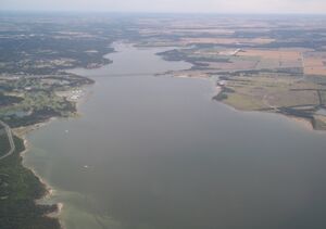 Lake Waco – southern half of the lake with State Highway 6 Twin Bridges in view |
الاقتصاد
According to the Greater Waco Chamber of Commerce, the top employers in the city as of July 2015 are:[12]
| # | رب العمل | الموظفون |
|---|---|---|
| 1 | جامعة بيلور | 2,675 |
| 2 | Waco Independent School District | 2,500 |
| 3 | Providence Health Center | 2,397 |
| 4 | L3 Technologies | 2,300 |
| 5 | Baylor Scott & White Health (Hillcrest) | 1,800 |
| 6 | Walmart | 1,656 |
| 7 | مدينة ويكو | 1,506 |
| 8 | H-E-B | 1,500 |
| 9 | Midway Independent School District | 1,067 |
| 10 | Sanderson Farms, Inc. | 1,041 |
الثقافة
المكتبات والمتاحف
الجغرافيا
المناخ
Waco experiences a humid subtropical climate (Köppen climate classification Cfa), characterized by hot summers and generally mild winters. Some 90 °F (32 °C) temperatures have been observed in every month of the year. The record low temperature is −5 °F (−21 °C), set on January 31, 1949; the record high temperature is 114 °F (46 °C), set on July 23, 2018.[13]
| بيانات المناخ لـ مطار ويكو الإقليمي، تكساس (1981–2010 normals,[14] extremes 1901–present) | |||||||||||||
|---|---|---|---|---|---|---|---|---|---|---|---|---|---|
| الشهر | ينا | فب | مار | أبر | ماي | يون | يول | أغس | سبت | أكت | نوف | ديس | السنة |
| القصوى القياسية °ف (°س) | 90 (32) |
96 (36) |
100 (38) |
101 (38) |
102 (39) |
109 (43) |
114 (46) |
112 (44) |
111 (44) |
101 (38) |
92 (33) |
91 (33) |
114 (46) |
| متوسط القصوى اليومية °ف (°س) | 58.2 (14.6) |
61.8 (16.6) |
69.2 (20.7) |
77.6 (25.3) |
85.0 (29.4) |
91.7 (33.2) |
96.3 (35.7) |
96.8 (36.0) |
89.8 (32.1) |
79.9 (26.6) |
68.5 (20.3) |
59.0 (15.0) |
77.9 (25.5) |
| متوسط الدنيا اليومية °ف (°س) | 36.1 (2.3) |
39.8 (4.3) |
47.1 (8.4) |
54.6 (12.6) |
63.8 (17.7) |
70.8 (21.6) |
74.1 (23.4) |
73.8 (23.2) |
66.4 (19.1) |
56.6 (13.7) |
46.5 (8.1) |
37.5 (3.1) |
55.7 (13.2) |
| متوسط الدنيا °ف (°س) | 21.1 (−6.1) |
23.1 (−4.9) |
29.3 (−1.5) |
36.7 (2.6) |
48.5 (9.2) |
60.4 (15.8) |
67.2 (19.6) |
65.5 (18.6) |
50.7 (10.4) |
39.4 (4.1) |
29.3 (−1.5) |
21.6 (−5.8) |
16.5 (−8.6) |
| الصغرى القياسية °ف (°س) | −5 (−21) |
−1 (−18) |
15 (−9) |
26 (−3) |
34 (1) |
52 (11) |
58 (14) |
53 (12) |
39 (4) |
25 (−4) |
17 (−8) |
−4 (−20) |
−5 (−21) |
| متوسط تساقط الأمطار inches (mm) | 2.12 (54) |
2.63 (67) |
3.15 (80) |
2.69 (68) |
4.30 (109) |
3.43 (87) |
1.79 (45) |
2.05 (52) |
3.06 (78) |
3.90 (99) |
2.82 (72) |
2.75 (70) |
34.69 (881) |
| Average precipitation days (≥ 0.01 in) | 7.1 | 6.8 | 8.3 | 6.3 | 8.1 | 7.5 | 5.3 | 5.0 | 5.8 | 7.2 | 7.3 | 7.1 | 81.8 |
| Source: NOAA[13][15] | |||||||||||||
انظر أيضاً
- 1953 Waco tornado outbreak
- Brazos Belle
- List of museums in Central Texas
- أحياء ويكو
- Waco Mammoth National Monument
- Fixer Upper
- Lynching of Jesse Washington
المراجع
- ^ "How Many of These Texas City Nicknames Do You Know?". Texas Standard. 29 July 2015. Retrieved 20 January 2020.
- ^ "2019 U.S. Gazetteer Files". United States Census Bureau. Retrieved August 7, 2020.
- ^ أ ب "Population and Housing Unit Estimates". Retrieved May 21, 2020.
- ^ "U.S. Census website". United States Census Bureau. Retrieved 2008-01-31.
- ^ "US Board on Geographic Names". United States Geological Survey. 2007-10-25. Retrieved 2008-01-31.
- ^ "Find a County". National Association of Counties. Archived from the original on 2011-05-31. Retrieved 2011-06-07.
- ^ American FactFinder, United States Census Bureau Archived 2012-05-05 at the Wayback Machine Retrieved 2011-11-01.
- ^ Decennial Census P.L. 94-171 Redistricting Data". United States Census Bureau, Population Division. Retrieved August 12, 2021.
- ^ American FactFinder, United States Census Bureau Archived 2011-06-07 at the Wayback Machine Retrieved 2011-11-01.
- ^ Metropolitan and Micropolitan Statistical Areas Totals: 2010-2020". United States Census Bureau, Population Division. May 2021. Retrieved May 31, 2021.
- ^ "Census of Population and Housing". Census.gov. Retrieved June 4, 2015.
- ^ "Customized Report". wacochamber.com.
- ^ أ ب "NowData – NOAA Online Weather Data". National Oceanic and Atmospheric Administration. Retrieved 2018-08-03.
- ^ Mean monthly maxima and minima (i.e. the expected highest and lowest temperature readings at any point during the year or given month) calculated based on data at said location from 1981 to 2010.
- ^ "Station Name: TX WACO RGNL AP". National Oceanic & Atmospheric Administration. Retrieved 2018-04-11.
ببليوگرافيا
وصلات خارجية
- Official website
- Waco, Texas from the Handbook of Texas Online
- Waco History Project
- Pages using gadget WikiMiniAtlas
- Articles with hatnote templates targeting a nonexistent page
- Missing redirects
- Short description is different from Wikidata
- Pages using infobox settlement with possible nickname list
- Coordinates on Wikidata
- Pages using US Census population needing update
- Pages with empty portal template
- واكو، تكساس
- مدن تكساس
- Cities in McLennan County, Texas
- County seats in Texas
- أماكن مأهولة تأسست في 1849
- تأسيسات 1849 في تكساس


