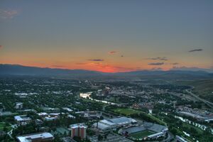
ميزولا، مونتانا
ميزولا
Missoula | |
|---|---|
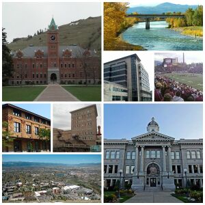 | |
| الكنية: The Garden City, River City, Zootown (informal)[1] | |
| الشعار: "The Discovery Continues"[1] | |
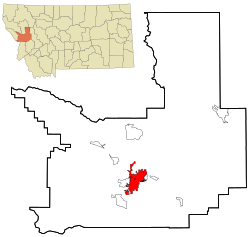 Location within Missoula County | |
| الإحداثيات: 46°51′45″N 114°0′42″W / 46.86250°N 114.01167°W | |
| Country | United States |
| State | Montana |
| County | Missoula |
| Founded | 1866 |
| Incorporated (town) | March 8, 1883 |
| Incorporated (city) | March 12, 1885 |
| أسسها | |
| الحكومة | |
| • النوع | Mayor–Council |
| • الكيان | Missoula City Council |
| • Mayor | John Engen (D) |
| المساحة | |
| • مدينة | 34٫66 ميل² (89٫76 كم²) |
| • البر | 34٫47 ميل² (89٫27 كم²) |
| • الماء | 0٫19 ميل² (0٫49 كم²) |
| • الحضر | 45٫43 ميل² (117٫7 كم²) |
| • العمران | 2،618 ميل² (6،780 كم²) |
| المنسوب | 3٬209 ft (978 m) |
| التعداد | |
| • مدينة | 66٬788 |
| • Estimate (2019)[4] | 75٬516 |
| • الترتيب | US: 480th |
| • الكثافة | 2٬191٫03/sq mi (845٫95/km2) |
| • العمرانية | 118٬791 (US: 327th) |
| منطقة التوقيت | UTC−7 (Mountain) |
| • الصيف (التوقيت الصيفي) | UTC−6 (Mountain) |
| ZIP code | 59801–59804, 59806–59808[5] |
| University of Montana ZIP code | 59812[5] |
| Area code | 406 |
| FIPS code | 30-50200 |
| GNIS feature ID | 0787504 |
| Highways | |
| الموقع الإلكتروني | ci.missoula.mt.us |
Missoula /mɪˈzuːlə/ (![]() استمع) is a city in the U.S. state of Montana; it is the county seat of Missoula County. It is located along the Clark Fork River near its confluence with the Bitterroot and Blackfoot Rivers in western Montana and at the convergence of five mountain ranges, thus it is often described as the "hub of five valleys".[6] In 2019[تحديث], the United States Census Bureau estimated the city's population at 75,516[7] and the population of the Missoula Metropolitan Area at 118,791.[8] After Billings, Missoula is the second-largest city and metropolitan area in Montana.[9] Missoula is home to the University of Montana, a public research university.
استمع) is a city in the U.S. state of Montana; it is the county seat of Missoula County. It is located along the Clark Fork River near its confluence with the Bitterroot and Blackfoot Rivers in western Montana and at the convergence of five mountain ranges, thus it is often described as the "hub of five valleys".[6] In 2019[تحديث], the United States Census Bureau estimated the city's population at 75,516[7] and the population of the Missoula Metropolitan Area at 118,791.[8] After Billings, Missoula is the second-largest city and metropolitan area in Montana.[9] Missoula is home to the University of Montana, a public research university.
The Missoula area was first settled in 1858 by William T. Hamilton with a trading post near current Missoula along the Rattlesnake Creek, by Captain Richard Grant, who settled near Grant Creek, and by David Pattee, who settled near Pattee Canyon.[10] Missoula was founded in 1860 as Hellgate Trading Post while still part of Washington Territory. By 1866, the settlement had moved east, 5 ميل (8 km) upstream, and had been renamed Missoula Mills, later shortened to Missoula.[11] The mills provided supplies to western settlers traveling along the Mullan Road. The establishment of Fort Missoula in 1877 to protect settlers further stabilized the economy. The arrival of the Northern Pacific Railway in 1883 brought rapid growth and the maturation of the local lumber industry. In 1893, the Montana Legislature chose Missoula as the site for the state's first university. Along with the U.S. Forest Service headquarters founded in 1908, lumber and the university remained the basis of the local economy for the next 100 years.[12]
By the 1990s, Missoula's lumber industry had gradually disappeared, and اعتبارا من 2009[تحديث], the city's largest employers were the University of Montana, Missoula County Public Schools, and Missoula's two hospitals.[13] The city is governed by a mayor–council government with 12 city council members, two from each of the six wards. In and around Missoula are 400 acre (160 ha) of parkland, 22 ميل (35 km) of trails, and nearly 5،000 acre (2،000 ha) of open-space conservation land, with adjacent Mount Jumbo being home to grazing elk and mule deer during the winter.[14] The city is also home to both of Montana's largest and its oldest active breweries, as well as the Montana Grizzlies, one of the strongest college football programs in the Division I Football Championship Subdivision of the National Collegiate Athletic Association. Notable residents include the first woman to serve in the U.S. Congress, Jeannette Rankin.[15]
التاريخ
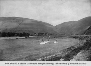
Archaeological artifacts date the earliest inhabitants of the Missoula Valley to 12,000 years ago with settlements as early as 3500 ق.م.. From the 1700s until 1850s, those who used the land were primarily, the Salish, Kootenai, Pend d'Oreille, Blackfeet, and Shoshone. Located at the confluence of five mountain valleys, the Missoula Valley was heavily traversed by local and distant native tribes that periodically went to the Eastern Montana plains in search of bison. This led to conflicts. The narrow valley at Missoula's eastern entrance was so strewn with human bones from repeated ambushes that French fur trappers later referred to this area as Porte de l'Enfer, translated as "Gate of Hell".[16] Hell Gate would remain the name of the area until it was renamed "Missoula" in 1866.[11]
The Lewis and Clark Expedition brought the first U.S. citizens to the area. They twice stopped just south of Missoula at Traveler's Rest.[17][18] They camped there the first time on their westbound trip in September 1805. When they stayed there again, on their return in June–July 1806, Clark left heading south along the Bitterroot River and Lewis traveled north, then east, through Hellgate Canyon. In 1860, Hell Gate Village was established 5 ميل (8 km) west of present-day downtown by Christopher P. Higgins and Frank Worden as a trading post to serve travelers on the recently completed Mullan Road, the first wagon road to cross the Rocky Mountains to the inland of the Pacific Northwest.[11] The desire for a more convenient water supply to power a lumber and flour mill led to the movement of the settlement to its modern location in 1864.[19]
The Missoula Mills replaced Hell Gate Village as the economic power of the valley and replaced it as the county seat in 1866. The name "Missoula" came from the Salish name for the Clark Fork River, nmesuletkw, which roughly translates as "place of frozen water".[20] Fort Missoula was established in 1877 to help protect further arriving settlers. Growth accelerated with the arrival of the Northern Pacific Railway in 1883, and by charter, Missoula incorporated a municipal government as a town, the same year.[21] In 1885, Missoula reincorporated its government as a city.
In 1893, Missoula was chosen as the location for the first state university, the University of Montana. The need for lumber for the railway and its bridges spurred the opening of multiple saw mills in the area, and in turn, the beginning of Missoula's lumber industry, which remained the mainstay of the area economy for the next 100 years.[12] The United States Forest Service work in Missoula began in 1905.[22] Missoula is also home of the smokejumpers' headquarters and will be the site of the National Museum of Forest Service History.[22] Nationally, there are nine Forest Service regions; Region 1 is headquartered in Missoula.[23]
Logging remained a mainstay of industry in Missoula with the groundbreaking of the Hoerner-Waldorf pulp mill in 1956, which resulted in protests over the resultant air pollution.[24] An article in Life 13 years later speaks of Missoulians sometimes needing to drive with headlights on during the day to navigate through the smog.[25] In 1979, almost 40% of the county labor income still came from the wood and paper-products sector.[26] The lumber industry was hit hard by the recession of the early 1980s and Missoula's economy began to diversify.[27] By the early 1990s, the disappearance of many of the region's log yards, along with legislation, had helped clean the air dramatically.[28]
اعتبارا من 2009[تحديث], education and healthcare were Missoula's leading industries; the University of Montana, Missoula County Public Schools, and the two hospitals in the city were the largest employers.[13] St. Patrick Hospital and Health Sciences Center, founded in 1873, is the region's only Level II trauma center and has undergone three major expansions since the 1980s.[29] Likewise, the University of Montana grew 50% and built or renovated 20 buildings from 1990–2010.[30] These industries, as well as expansions in business and professional services, and retail are expected to be the main engines of future growth.[31]
الجغرافيا
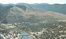
Missoula is located at the western edge of Montana, approximately 45 ميل (70 km) from the Idaho border. The city is at an elevation of 3،209 أقدام (978 m) above sea level, with nearby Mount Sentinel and Mount Jumbo steeply rising to 5،158 أقدام (1،572 m) and 4،768 أقدام (1،453 m), respectively. According to the Census Bureau's 2015[تحديث] figures, the city had a total area of 29.08 ميل مربع (75.3 km2), of which 28.90 ميل مربع (74.9 km2) were land and 0.184 ميل مربع (0.48 km2) were covered by water.[32]
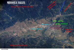
Around 13,000 years ago, the entire valley was at the bottom of Glacial Lake Missoula. As could be expected for a former lake bottom, the layout of Missoula is relatively flat and surrounded by steep hills. Evidence of the city of Missoula's lake-bottom past can be seen in the form of ancient horizontal wave-cut shorelines on nearby Mount Sentinel and Mount Jumbo.[33] At the location of present-day University of Montana, the lake once had a depth of 950 أقدام (290 m).[34] The Clark Fork River enters the Missoula Valley from the east through Hellgate Canyon after joining the nearby Blackfoot River at the site of the former Milltown Dam. The Bitterroot River and multiple smaller tributaries join the Clark Fork on the western edge of Missoula. The city also sits at the convergence of five mountain ranges: the Bitterroot Mountains, Sapphire Range, Garnet Range, Rattlesnake Mountains, and the Reservation Divide, thus is often described as being the "hub of five valleys".[6]
النبيت والوحيش
Located in the Northern Rockies, Missoula has a typical Rocky Mountain ecology. Local wildlife includes populations of white-tailed deer, moose, grizzly bears, black bears, osprey, and bald eagles. During the winter, rapid snowmelt on Mount Jumbo due to its steep slope leaves grass available for grazing elk and mule deer. The rivers around Missoula provide nesting habitats for bank swallows, northern rough-winged swallows, and belted kingfishers. Killdeer and spotted sandpipers can be seen foraging for insects along the gravel bars. Other species include song sparrows, catbirds, several species of warblers, and the pileated woodpecker. The rivers also provide cold, clean water for native fish such as westslope cutthroat trout and bull trout. The meandering streams also attract beaver and wood ducks.[35] The parks also host a variety of snakes such as racers, garter snakes, and rubber boa.
Native riparian plant life includes sandbar willows and cottonwoods with Montana's state tree, the ponderosa pine, also being prevalent. Other native plants include wetland species such as cattails and beaked sedge, as well as shrubs and berry plants such as Douglas hawthorn, chokecherry, and western snowberries.[35] To the chagrin of local farmers, Missoula is also home to several noxious weeds, which multiple programs have set out to eliminate. Notable ones include Dalmatian toadflax, spotted knapweed, leafy spurge, St. John's wort, and sulfur cinquefoil.[36] Controversially, the Norway maples that line many of Missoula's older streets have also been declared an invasive species.[37]
المناخ
Missoula has a cool-summer humid continental climate (Köppen climate classification Dfb),[38] with cold and moderately snowy winters, hot and dry summers, and short, crisp springs and autumns. Winters are usually milder than much of the rest of the state due to Missoula's location west of the Rockies, allowing it to receive mild, moist Pacific air and avoid the worst of cold snaps; however, it also gets more precipitation in winter. Winter snowfall averages 39.5 بوصات (100 cm), typically occurring between October 30 and April 20. As with the rest of the state, summers are very sunny, and the average diurnal temperature variation is more than 30 °F (17 °C) from late June through late September, due to the relative aridity.[39][40] The monthly daily average temperature ranges from 23.9 °F (−4.5 °C) in December to 68.6 °F (20.3 °C) in July. On average, annually, there are 24 days with temperatures at or above 90 °F (32 °C), 45 days where the temperature does not rise above freezing, and 7.8 days with temperatures reaching at or below 0 °F (−18 °C).[41] Record temperatures range from −33 °F (−36 °C) on January 26, 1957 up to 107 °F (42 °C) on July 6, 2007;[41] the record cold maximum is −13 °F (−25 °C), last recorded on February 2, 1989, while, conversely, the record warm minimum is 72 °F (22 °C) on July 27, 1939.[41]
| بيانات المناخ لـ ميزولا، منوتانا (Missoula Airport) 1981–2010 normals,[أ] extremes 1893–present | |||||||||||||
|---|---|---|---|---|---|---|---|---|---|---|---|---|---|
| الشهر | ينا | فب | مار | أبر | ماي | يون | يول | أغس | سبت | أكت | نوف | ديس | السنة |
| القصوى القياسية °ف (°س) | 60 (16) |
66 (19) |
78 (26) |
90 (32) |
95 (35) |
102 (39) |
107 (42) |
105 (41) |
99 (37) |
85 (29) |
73 (23) |
60 (16) |
107 (42) |
| متوسط القصوى اليومية °ف (°س) | 33.2 (0.7) |
38.8 (3.8) |
49.8 (9.9) |
58.5 (14.7) |
67.3 (19.6) |
75.2 (24.0) |
85.9 (29.9) |
84.9 (29.4) |
73.1 (22.8) |
57.8 (14.3) |
41.5 (5.3) |
31.0 (−0.6) |
58.2 (14.6) |
| متوسط الدنيا اليومية °ف (°س) | 18.3 (−7.6) |
21.2 (−6.0) |
27.7 (−2.4) |
32.8 (0.4) |
39.8 (4.3) |
46.6 (8.1) |
51.4 (10.8) |
50.1 (10.1) |
41.8 (5.4) |
32.4 (0.2) |
24.9 (−3.9) |
16.7 (−8.5) |
33.7 (0.9) |
| متوسط الدنيا °ف (°س) | −3.9 (−19.9) |
0.0 (−17.8) |
13.5 (−10.3) |
22.0 (−5.6) |
27.0 (−2.8) |
35.0 (1.7) |
40.5 (4.7) |
40.0 (4.4) |
29.4 (−1.4) |
18.0 (−7.8) |
7.8 (−13.4) |
−3.3 (−19.6) |
−13.6 (−25.3) |
| الصغرى القياسية °ف (°س) | −33 (−36) |
−28 (−33) |
−13 (−25) |
2 (−17) |
21 (−6) |
26 (−3) |
27 (−3) |
25 (−4) |
15 (−9) |
−4 (−20) |
−23 (−31) |
−30 (−34) |
−33 (−36) |
| متوسط تساقط الأمطار inches (mm) | 0.85 (22) |
0.70 (18) |
1.00 (25) |
1.22 (31) |
2.01 (51) |
2.07 (53) |
0.99 (25) |
1.19 (30) |
1.17 (30) |
0.88 (22) |
1.01 (26) |
1.04 (26) |
14.13 (359) |
| متوسط هطول الثلج inches (cm) | 8.3 (21) |
6.1 (15) |
5.1 (13) |
1.2 (3.0) |
0.2 (0.51) |
trace | 0 (0) |
0 (0) |
trace | 0.6 (1.5) |
5.4 (14) |
11.0 (28) |
37.9 (96) |
| Average precipitation days (≥ 0.01 in) | 11.8 | 9.4 | 11.4 | 11.1 | 12.3 | 12.1 | 7.1 | 7.5 | 8.2 | 8.4 | 11.1 | 12.3 | 122.7 |
| متوسط الرطوبة النسبية (%) | 81.3 | 78.1 | 70.3 | 61.2 | 61.7 | 61.1 | 51.7 | 52.5 | 62.8 | 70.8 | 80.2 | 83.5 | 67.9 |
| متوسط نقطة الندى °ف (°س) | 17.2 (−8.2) |
21.7 (−5.7) |
25.3 (−3.7) |
29.7 (−1.3) |
37.2 (2.9) |
44.4 (6.9) |
45.7 (7.6) |
44.4 (6.9) |
39.7 (4.3) |
32.7 (0.4) |
25.9 (−3.4) |
18.7 (−7.4) |
31.9 (−0.1) |
| Mean monthly ساعات سطوع الشمس | 95.8 | 133.0 | 209.3 | 245.0 | 280.5 | 311.1 | 389.3 | 334.8 | 264.7 | 194.3 | 99.5 | 82.9 | 2٬640٫2 |
| نسبة السطوع المحتمل للشمس | 34 | 46 | 57 | 60 | 60 | 66 | 81 | 76 | 70 | 58 | 35 | 31 | 59 |
| Source: NOAA (relative humidity, dew point, and sun 1961–1990)[41][42][43] | |||||||||||||
الديمغرافيا
| التعداد | Pop. | ملاحظة | %± |
|---|---|---|---|
| 1870 | 400 | — | |
| 1880 | 347 | −13٫2% | |
| 1890 | 3٬426 | 887٫3% | |
| 1900 | 4٬366 | 27٫4% | |
| 1910 | 12٬896 | 195٫4% | |
| 1920 | 12٬668 | −1٫8% | |
| 1930 | 14٬657 | 15٫7% | |
| 1940 | 18٬449 | 25٫9% | |
| 1950 | 22٬485 | 21٫9% | |
| 1960 | 27٬090 | 20٫5% | |
| 1970 | 29٬497 | 8٫9% | |
| 1980 | 33٬388 | 13٫2% | |
| 1990 | 42٬918 | 28٫5% | |
| 2000 | 57٬053 | 32٫9% | |
| 2010 | 66٬788 | 17٫1% | |
| 2019 (تق.) | 75٬516 | [4] | 13٫1% |
| Sources: 1870–1990,[44] 2000–2010,[9] | |||
| Highest Educational Attainment Population 25 years and over (2014) |
Missoula[45] | Montana[45] | U.S.[45] | |
|---|---|---|---|---|
| Less than 9th grade | 1.2% | 2.2% | 5.8% | |
| 9th to 12th grade, no diploma | 3.3% | 5.3% | 7.8% | |
| High school graduate or equivalent | 19.0% | 29.8% | 28.0% | |
| Some college | 24.1% | 25.3% | 21.2% | |
| Associate degree | 6.7% | 8.3% | 7.9% | |
| Bachelor's degree | 28.0% | 19.8% | 18.3% | |
| Graduate or professional degree | 17.7% | 9.2% | 11.0% | |
| High school or higher | 95.5% | 92.4% | 86.3% | |
| Bachelor's degree or higher | 45.7% | 29.1% | 29.3% | |
The median income for a household in the city was $30,366, and for a family was $42,103. Males had a median income of $30,686 versus $21,559 for females. The per capita income for the city was $17,166. About 11.7% of families and 19.7% of the population were below the poverty line, including 20.5% of those under age 18 and 9.3% of those age 65 or over. About 40.3% of Missoula residents age 25 and older have a bachelor's or advanced college degree.
تعداد 2010
اعتبارا من 2010[تحديث]'s census, 66,788 people, 29,081 households, and 13,990 families resided in the city.[3] The population density was 2،427.8 inhabitants per square mile (937.4/km2). The 30,682 housing units averaged 1،115.3 per square mile (430.6/km2). The racial makeup of the city was 92.1% White, 0.5% African American, 2.8% Native American, 1.2% Asian, 0.6% from other races, and 2.8% from two or more races. Latinos of any race were 2.9% of the population.
Of the 29,081 households, 23.6% had children under the age of 18 living with them, 34.4% were married couples living together, 9.6% had a female householder with no husband present, 4.1% had a male householder with no wife present, and 51.9% were not families. About 35.0% of all households were made up of individuals, and 9.1% had someone living alone who was 65 years of age or older. The average household size was 2.18 and the average family size was 2.82.
In the city, the population was distributed as 17.9% of residents under 18, 19.7% between the ages of 18 and 24, 29.6% from 25 to 44, 22.1% from 45 to 64, and 10.7% who were 65 years of age or older. The median age in the city was 30.9 years. The gender makeup of the city was 49.9% male and 50.1% female.
الهامش
- ^ Mean monthly maxima and minima (i.e. the expected highest and lowest temperature readings at any point during the year or given month) calculated based on data at said location from 1981 to 2010.
- ^ أ ب "About Missoula". Destination Missoula. Archived from the original on June 11, 2015. Retrieved August 26, 2015.
- ^ "2019 U.S. Gazetteer Files". United States Census Bureau. Retrieved July 26, 2020.
- ^ أ ب "American FactFinder: Profile of General Population and Housing Characteristics". United States Census Bureau. Archived from the original on February 13, 2020. Retrieved August 25, 2015.
- ^ أ ب "Population and Housing Unit Estimates". United States Census Bureau. May 24, 2020. Retrieved May 27, 2020.
- ^ أ ب "Look Up a ZIP Code". USPS. Archived from the original on August 9, 2015.
- ^ أ ب Gilder, Don. "Three, Five or Eight: Judge Woody Would Hold His Nose". Old Missoula. Archived from the original on August 15, 2015. Retrieved August 15, 2015.
- ^ "2018 city estimate". Retrieved June 18, 2019.
- ^ "U.S. Census website". United States Census Bureau. June 18, 2019. Retrieved June 19, 2019.
- ^ أ ب "U.S. Census Bureau Delivers Montana's 2010 Census Population Totals, Including First Look at Race and Hispanic Origin Data for Legislative Redistricting". Census 2010 News. United States Census Bureau. Archived from the original on March 8, 2013. Retrieved August 23, 2015.
- ^ Allan James Mathews (2002). A Guide to Historic Missoula. Montana Historical Society. p. 164. ISBN 978-0-917298-89-9. Archived from the original on June 12, 2018.
- ^ أ ب ت theBeginning/EarlyEarlyMissoula/tabid/192/Default.aspx "Early, Early Missoula". Historic Missoula. Missoula's Office of Planning and Grants. Retrieved August 8, 2015.
{{cite web}}: Check|url=value (help)[dead link] - ^ أ ب "Arrival of the Railroad (1883–1893)". Historic Missoula. Missoula's Office of Planning and Grants. Archived from the original on February 14, 2015. Retrieved August 8, 2015.
- ^ أ ب "Top employers in the city of Missoula". Missoulian. Missoula. December 15, 2009. ISSN 0746-4495. Archived from the original on September 15, 2017. Retrieved August 14, 2015.
- ^ "Missoula Official Website: Parks & Recreation". City of Missoula. Archived from the original on August 9, 2015. Retrieved August 9, 2015.
- ^ "Cool Montana Stories: Jeannette Rankin". Travel Montana. 2007. Archived from the original on July 1, 2015. Retrieved August 13, 2015.
- ^ "Cities and Towns § Missoula". Montana: A State Guide Book. Works Progress Administration: American Guide. Compiled by the Federal Writers' Project (4th ed.). New York: Hastings House Publishers. 1955 [1st pub. 1939]. p. 173. ISBN 978-0-403-02176-5. OCLC 869757480. Archived from the original on September 4, 2015. Retrieved August 28, 2015.
The Salish had to pass through Hell Gate Canyon to reach the plains on their periodic buffalo hunts. At the entrance to the canyon, an ideal spot for an ambush, the Blackfeet would attack them. The reputation of the place caused French-Canadian trappers to call it Porte de l'Enfer or 'Gate of Hell'.
{{cite book}}: CS1 maint: others (link) - ^ "Travelers Rest". Montana Fish, Wildlife & Parks. Montana State Parks. Archived from the original on September 5, 2015. Retrieved October 5, 2015.
- ^ "Meriwether Lewis". TwoRiversHistory.net. Archived from the original on May 22, 2011. Retrieved February 8, 2012.
- ^ "Hell Gate Village Era (1860–1865)". Historic Missoula. Missoula's Office of Planning and Grants. Archived from the original on February 3, 2015. Retrieved August 8, 2015.
- ^ "Livability" (PDF). City of Missoula. Archived from the original on August 23, 2015. Retrieved August 23, 2015.
Missoula's name is derived from "nmesuletkw", the Salish word for the Clark Fork River, which translates to, "place of frozen water".
- ^ "Missoula History". Destination Missoula. Archived from the original on August 12, 2015. Retrieved August 24, 2015.
- ^ أ ب "About Us: Frequently Asked Questions". National Museum of Forest Service History. Archived from the original on October 22, 2014. Retrieved August 26, 2015.
- ^ "Our Organization". United States Forest Service. United States Department of Agriculture. Archived from the original on June 28, 2018. Retrieved August 25, 2018.
- ^ Briggeman, Kim (February 29, 2008). "Missoula anti-pollution group celebrates its victories". Independent Record. Helena. Archived from the original on September 13, 2017. Retrieved August 28, 2015.
- ^ Hall, Richard (February 7, 1969). "Air Pollution". Life. Vol. 66, no. 5. New York: Time. pp. 42–43. ISSN 0024-3019. Archived from the original on September 4, 2015. Retrieved August 28, 2015.
As they drive to work through it—sometimes with their car lights turned on in broad daylight—Missoulians complain a lot.
- ^ "In the beginning of the MAEDC". Missoulian. Missoula. August 14, 2010. ISSN 0746-4495. Archived from the original on September 15, 2017. Retrieved January 28, 2012.
- ^ Polzin, Paul E. (Spring 1994). "Montana's Economy: State of the Economy". Montana Business Quarterly. UM Bureau of Business and Economic Research. 32 (1): 6–15. ProQuest 234227618.
- ^ "Missoula Carbon Monoxide SIP Case History". Citizen's Guide to Air Quality in Montana. Montana Department of Environmental Quality. Archived from the original on January 22, 2016.
- ^ "St. Patrick Hospital, Missoula, Montana". Archived from the original on September 5, 2015. Retrieved August 8, 2015.
- ^ "George M. Dennison". University of Montana. Archived from the original on March 30, 2012. Retrieved April 22, 2012.
- ^ Cohen, Betsy (December 18, 2009). "Slow economic growth forecast for 2010; Missoula will soon be largest city in Montana". Missoulian. Missoula. ISSN 0746-4495. Archived from the original on September 15, 2017. Retrieved January 28, 2012.
- ^ "Gazetteer Files: Montana Places". United States Census Bureau. 2015. Archived from the original on August 28, 2015.
- ^ "Section D: Background". Ice Age Floods: Study of Alternatives and Environmental Assessment. Seattle: National Park Service. 2001. Archived from the original on June 11, 2015. Retrieved August 24, 2015.
- ^ "Glacial Lake Missoula". United States Geological Survey. Archived from the original on August 9, 2015. Retrieved August 9, 2015.
- ^ أ ب "Missoula Conservation Lands Management Plan" (PDF). Missoula Parks and Recreation. June 1, 2010. Archived from the original on July 23, 2012. Retrieved August 24, 2015.
- ^ Rice, Peter M. "Blackfoot Drainage New Weeds Risk Assessment". Invaders Database System. Missoula: University of Montana. Archived from the original on December 21, 2014. Retrieved October 2, 2015.
- ^ Chaney, Rob (September 28, 2011). "City sees some success removing Norway maples from Greenough Park". Missoulian. Missoula. ISSN 0746-4495. Archived from the original on September 15, 2017. Retrieved August 9, 2015.
- ^ Pereira, Amanda Goebel, ed. (June 27, 2017). "FirstNet Nationwide Public Safety Broadband Network: Final Programmatic Environmental Impact Statement for the Central United States" (PDF). Washington, D.C.: U.S. Department of Commerce. p. 11- [ك]221. Archived (PDF) from the original on October 8, 2018. Retrieved August 25, 2018.
Missoula, in western Montana, is within the climate classification zone Dfb. The average annual temperature in Missoula is approximately 45.9 °F [7.7 °C]; 26.4 °F [−3.1 °C] during winter months; 65.7 °F [18.7 °C] during summer months; 46.0 °F [7.8 °C] during spring months; and 45.2 °F [7.3 °C] during autumn months.
- ^ "Station Information Data Sheet: Missoula, Montana". NOAA. January 1998. Archived from the original on July 24, 2014. Retrieved January 28, 2012.
- ^ "Climatography of the United States No. 20 1971–2000" (PDF). NOAA. February 2004. Archived from the original (PDF) on February 12, 2015. Retrieved August 8, 2015.
- ^ أ ب ت ث "NowData: NOAA Online Weather Data". National Oceanic and Atmospheric Administration. Archived from the original on September 4, 2015. Retrieved 2020-07-28.
- ^ "Temperature-Related Normals: Missoula, Montana International Airport". National Oceanic and Atmospheric Administration. Retrieved September 10, 2015.
- ^ "WMO Climate Normals for Missoula/Johnson–Bell Field, MT 1961–1990". National Oceanic and Atmospheric Administration. Retrieved 2020-07-28.
- ^ Moffatt, Riley (1996). "Montana". Population History of Western U.S. Cities and Towns, 1850–1990. Lanham, Maryland: Scarecrow Press. p. 133. ISBN 0-8108-3033-7. LCCN 95-14583. OCLC 32274538. OL 2912313W.
- ^ أ ب ت "Educational Attainment: 2010–2014 American Community Survey 5‑Year Estimates". American FactFinder. United States Census Bureau. 2014. Archived from the original on February 14, 2020. Retrieved March 4, 2016.
وصلات خارجية
- Official website

- Missoula Visitors Bureau
- Missoula Chamber of Commerce
- ميزولا، مونتانا at Curlie
 "[[s:Collier's New Encyclopedia (1921)/{{{1}}}|{{{1}}}]]". Collier's New Encyclopedia. 1921.
- Missoula Collection Guide (University of Montana Archives)
- City of Missoula (Mont.) Records, 1883-2009 (University of Montana Archives)
قالب:Missoula, Montana قالب:Missoula County, Montana
قالب:Montana Regions and Towns with Breweries قالب:Montana county seats
- Pages using gadget WikiMiniAtlas
- CS1 errors: URL
- Articles with dead external links from July 2020
- CS1 maint: others
- Short description is different from Wikidata
- Articles with hatnote templates targeting a nonexistent page
- Missing redirects
- Pages using infobox settlement with possible nickname list
- Coordinates on Wikidata
- Pages including recorded pronunciations
- مقالات فيها عبارات متقادمة منذ 2019
- جميع المقالات التي فيها عبارات متقادمة
- مقالات فيها عبارات متقادمة منذ 2009
- Articles containing فرنسية-language text
- مقالات فيها عبارات متقادمة منذ 2015
- Pages using US Census population needing update
- مقالات فيها عبارات متقادمة منذ 2010
- Articles with Curlie links
- ميزولا، مونتانا
- Cities in Montana
- Cities in Missoula County, Montana
- County seats in Montana
- Metropolitan areas of Montana
- Populated places established in 1860
- 1866 establishments in Montana Territory


