مقاطعة مسكوگي، أوكلاهوما
Muskogee County | |
|---|---|
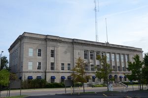
 Muskogee County Courthouse in September 2015 | |
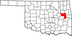
 الموقع ضمن ولاية Oklahoma | |
 موقع Oklahoma ضمن الولايات المتحدة | |
| الإحداثيات: 35°37′N 95°23′W / 35.61°N 95.38°W | |
| البلد | |
| State | |
| تأسست | 1907 |
| Seat | Muskogee |
| أكبر مدينة | Muskogee |
| المساحة | |
| • الإجمالي | 840 ميل² (2٬200 كم²) |
| • البر | 810 ميل² (2٬100 كم²) |
| • الماء | 29 ميل² (80 كم²) 3.5%% |
| التعداد | |
| • Estimate (2018) | 68٬362 |
| • الكثافة | 88/sq mi (34/km2) |
| Congressional district | 2nd |
مقاطعة مسكوگي إنگليزية: Muskogee County هي إحدى مقاطعات ولاية أوكلاهوما في الولايات المتحدة الأمريكية.
المقاطعات المجاورة
- Wagoner County (north)
- Cherokee County (northeast)
- Sequoyah County (east)
- Haskell County (southeast)
- McIntosh County (southwest)
- Okmulgee County (west)
National protected area
Government
The county seat of the County is Muskogee, Oklahoma. All elected officials and county services are headquartered there.
| Office | Current Officer | Since | Party |
|---|---|---|---|
| County Commissioner - District 1 | Ken Doke | 2014 | Republican |
| County Commissioner - District 2 | Stephen Wright | 2009 | Democratic |
| County Commissioner - District 3 | Kenny Payne | 2014 | Democratic |
| County Sheriff | Rob Frazier | 2001 | Democratic |
| County Clerk | Dianna Cope | 2012 | Democratic |
| County Treasurer | Kelly Garrett | 2011 | Democratic |
| County Assessor | Dan Ashwood | Democratic | |
| District Attorney | Orvil Loge | 2014 | Democratic |
| District Court Clerk | Paula Sexton | 2002 | Democratic |
الديمغرافيا
| التعداد | Pop. | ملاحظة | %± |
|---|---|---|---|
| 1910 | 52٬743 | — | |
| 1920 | 61٬710 | 17�0% | |
| 1930 | 66٬424 | 7٫6% | |
| 1940 | 65٬914 | −0٫8% | |
| 1950 | 65٬573 | −0٫5% | |
| 1960 | 61٬866 | −5٫7% | |
| 1970 | 59٬542 | −3٫8% | |
| 1980 | 66٬939 | 12٫4% | |
| 1990 | 68٬078 | 1٫7% | |
| 2000 | 69٬451 | 2�0% | |
| 2010 | 70٬990 | 2٫2% | |
| 2018 (تق.) | 68٬362 | [1] | −3٫7% |
| U.S. Decennial Census[2] 1790-1960[3] 1900-1990[4] 1990-2000[5] 2010-2013[6] | |||
السياسة
#3333FF #E81B23 #DDDDBB| Voter Registration and Party Enrollment as of January 15, 2019[7] | |||||
|---|---|---|---|---|---|
| Party | Number of Voters | Percentage | |||
| Democratic | 19,164 | 51.64% | |||
| Republican | 12,420 | 33.47% | |||
| Others | 5,528 | 14.90% | |||
| Total | 37,112 | 100% | |||
Presidential elections results
| Year | Republican | Democratic | Third parties |
|---|---|---|---|
| 2016 | 62.1% 15,043 | 32.9% 7,977 | 4.9% 1,196 |
| 2012 | 57.4% 13,404 | 42.6% 9,952 | |
| 2008 | 57.5% 15,289 | 42.5% 11,294 | |
| 2004 | 54.6% 15,124 | 45.4% 12,585 | |
| 2000 | 47.9% 11,820 | 50.7% 12,520 | 1.4% 353 |
| 1996 | 35.6% 8,974 | 51.5% 12,963 | 12.9% 3,243 |
| 1992 | 31.4% 8,782 | 48.8% 13,619 | 19.8% 5,531 |
| 1988 | 44.5% 11,147 | 54.9% 13,760 | 0.6% 161 |
| 1984 | 53.9% 14,652 | 45.4% 12,343 | 0.7% 188 |
| 1980 | 44.8% 11,511 | 51.9% 13,341 | 3.4% 863 |
| 1976 | 40.9% 10,287 | 58.4% 14,678 | 0.8% 190 |
| 1972 | 65.7% 15,161 | 32.0% 7,380 | 2.4% 551 |
| 1968 | 38.4% 8,707 | 41.3% 9,377 | 20.3% 4,596 |
| 1964 | 34.3% 8,508 | 65.8% 16,330 | |
| 1960 | 52.8% 12,403 | 47.2% 11,082 | |
| 1956 | 51.5% 11,057 | 48.5% 10,413 | |
| 1952 | 47.5% 11,810 | 52.5% 13,040 | |
| 1948 | 32.2% 6,592 | 67.8% 13,860 | |
| 1944 | 41.4% 8,280 | 58.4% 11,679 | 0.2% 31 |
| 1940 | 42.5% 9,585 | 57.3% 12,917 | 0.2% 49 |
| 1936 | 32.5% 6,452 | 67.3% 13,344 | 0.2% 33 |
| 1932 | 29.8% 5,351 | 70.2% 12,621 | |
| 1928 | 60.9% 9,972 | 38.8% 6,343 | 0.3% 54 |
| 1924 | 45.0% 6,158 | 50.3% 6,895 | 4.7% 644 |
| 1920 | 44.5% 5,187 | 54.7% 6,378 | 0.9% 99 |
| 1916 | 36.8% 2,532 | 58.2% 4,004 | 4.9% 340 |
| 1912 | 36.1% 2,385 | 55.7% 3,681 | 8.3% 549 |
الهامش
- ^ "Population and Housing Unit Estimates". Retrieved December 26, 2019.
- ^ "U.S. Decennial Census". United States Census Bureau. Retrieved February 21, 2015.
- ^ "Historical Census Browser". University of Virginia Library. Retrieved February 21, 2015.
- ^ Forstall, Richard L., ed. (March 27, 1995). "Population of Counties by Decennial Census: 1900 to 1990". United States Census Bureau. Retrieved February 21, 2015.
- ^ "Census 2000 PHC-T-4. Ranking Tables for Counties: 1990 and 2000" (PDF). United States Census Bureau. April 2, 2001. Retrieved February 21, 2015.
- ^ خطأ استشهاد: وسم
<ref>غير صحيح؛ لا نص تم توفيره للمراجع المسماةQF - ^ "Oklahoma Registration Statistics by County" (PDF). OK.gov. January 15, 2019. Retrieved 2019-02-27.
- ^ Leip, David. "Dave Leip's Atlas of U.S. Presidential Elections". uselectionatlas.org. Retrieved 10 April 2018.
?
تصنيفات:
- Pages using gadget WikiMiniAtlas
- Articles with hatnote templates targeting a nonexistent page
- Short description is different from Wikidata
- Coordinates on Wikidata
- مقاطعات Oklahoma
- Articles containing إنگليزية-language text
- Pages using Lang-xx templates
- Pages using US Census population needing update
- Muskogee County, Oklahoma
- 1907 establishments in Oklahoma
- Populated places established in 1907
- مقاطعات أوكلاهوما
