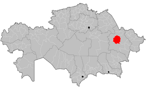
مقاطعة أباي، منطقة أباي
أباي
Abai audany Abai | |
|---|---|
مقاطعة | |
| Абай ауданы | |
 | |
| الإحداثيات: 48°56′38″N 79°15′58″E / 48.944°N 79.266°E | |
| البلد | |
| المنطقة | منطقة أباي |
| المركز الإداري | قرة أول |
| تأسست | 1928 |
| الحكومة | |
| • أقيم | مسافربكوف طورسونغازي جانتوياكوڤتش |
| المساحة | |
| • الإجمالي | 20٬093 كم² (7٬758 ميل²) |
| التعداد (2013)[1] | |
| • الإجمالي | 15٬228 |
| منطقة التوقيت | UTC+6 (East) |
أباي (بالقزخية: Абай ауданы، Abai audany، اباي اۋدانى ؛ Abai) هي مقاطعة في منطقة أباي في شرق قزاقستان. المركز الإداري للمقاطعة هو قرية قرة أول.[2] Population: 15٬228 (تقدير 2013);[1] 15,258 (نتائج تعداد 2009);[3] 17,885 (نتائج تعداد 1999).[3]
الجغرافيا
Located at the foot of the Chingiztau Mountains southwest of Semey . The western and northern part of the region is occupied by a low-hill plain; elevations, hills, low ridges alternate with numerous depressions. The southwestern part is occupied by the low mountains Khanshyngys (1152 m) and Shyngystau (1077 m), in the west - Degelen, Ordatas, in the east - Dos, Myrzhyk. Minerals: marble , granite , pebbles , sands and other building materials [6] .
The climate is sharply continental . The average temperature in January is -15.5°C; in July - 20.5 ° C. The volume of annual precipitation is 250-300 mm. The rivers Shagan , Ashchysu , Bokenshi flow through the territory of the region . Many rivers that dry up in summer, salt and sor lakes. Soils are chestnut , mostly solonetzic. Feather grass and wormwood grow ; on the slopes of the mountains - poplar , birch ; along the river valleys - willow , currant , bird cherry . There are argali , roe deer , wolf ,fox , corsac , badger , ferret , ground squirrel ; bustard , black grouse , hoof , quail , crane , goose , duck and others nest .
التاريخ
On January 17, 1928, the Chingistau district of the Semipalatinsk district (approved by the All-Russian Central Executive Committee on September 3, 1928) was formed from the Chagan, Chingiz and Lunacharskaya volosts of the Semipalatinsk district with the center in the Dogolok tract.
By the Decree of the Central Executive Committee of the Kazakh ASSR of November 20-21, 1930, the Chingistau district was renamed Goloshchekinsky .
On December 17, 1930, the old name of the district Chingistausky was restored .
On February 20, 1932 (approved by the All-Russian Central Executive Committee on March 10, 1932), the East Kazakhstan region was formed, which included the Chingistau region with a center in the village of Kara-aul.
By the Decree of the Presidium of the Supreme Soviet of the Kazakh SSR dated December 14, 1939, the Chingistau district of the East Kazakhstan region was transferred to the Semipalatinsk region .
By the Decree of the Presidium of the Supreme Council of the Kazakh SSR dated October 5, 1940, in connection with the 95th anniversary of the birth of the great Kazakh poet Abai Kunanbaev, the Chingistau region was renamed into the Abaevsky region .
By the Decree of the Presidium of the Supreme Council of the Kazakh SSR dated October 29, 1953, the Abaevsky district was renamed into the Abaysky district .
By the Decree of the Supreme Council of the Kazakh SSR of December 15, 1990, four village councils were transferred to the restored Abralinsky district .
By the Decree of the President of the Republic of Kazakhstan dated May 3, 1997, the Semipalatinsk region was abolished, the territory of the district was included in the East Kazakhstan region [7] .
In order to avoid confusion with other districts of the same name, public figures are invited to return the historical name - Shyngystau district.
السكان
التركيبة العرقية (في بداية 2019 ):
- قزاق - 14,261 نسمة. (98.91%)
- روس - 92 نسمة. (0.64%)
- أويغور - 35 نسمة. (0.24%)
- تتار - 18 نسمة. (0.12%)
- غيرهم - 11 نسمة. (0.08%)
- الإجمالي - 14 418 نسمة. (100.00%)
التقسيمات الإدارية
تنقسم مقاطعة أباي إلى 9 rural districts، يوجد فيهم 11 مستوطنة ريفية:
| Сельский округ | المستوطنات |
| Архатский сельский округ | أرخات، قرية أوردا |
| Карааульский сельский округ | قرة أول |
| Каскабулакский сельский округ | كاسكابولاق، بورلي |
| Кенгирбайбийский сельский округ | كنگيرباي بي |
| Кокбайский сельский округ | كوكباي |
| Кундыздинский сельский округ | جورىقادير |
| Медеуский сельский округ | مديو |
| Сарыжалский сельский округ | ساري جال |
| Токтамысский сельский округ | تقتميس |
الاقتصاد
The leading branch of agriculture is animal husbandry ( sheep breeding , cattle breeding , horse breeding , camel breeding ). Grow potatoes and vegetables. Highways of local importance.
المعالم
In the area there are museums of Abai Kunanbaev and Mukhtar Auezov , the memorial complex of Abai and Shakarim, the folk theater, the Zhidebai reserve, the mausoleum of Kengirbai Zhandosuly , the caves of Konyr-Auliye and Sarykol, the Enlik-Kebek monument and other memorable places of historical and tourist importance.
المراجع
- ^ أ ب "Население Республики Казахстан" (in الروسية). Департамент социальной и демографической статистики. Retrieved 27 December 2013.
- ^ "www.geonames.de Subdivisions of Kazakhstan in local languages". Archived from the original on 2016-03-03. Retrieved 2008-04-21.
- ^ أ ب "Население Республики Казахстан" (in Russian). Департамент социальной и демографической статистики. Retrieved 8 December 2013.
{{cite web}}: CS1 maint: unrecognized language (link)

