فرايبرغ
| وائل سلمان عجام ساهم بشكل رئيسي في تحرير هذا المقال
|
فرايبرگ | |
|---|---|
 فرايبرگ | |
 Coat of arms | |
موقع فرايبرگ within ساكسونيا الوسطى district  | |
 فرايبرگ  فرايبرگ | |
| الإحداثيات: 50°54′43″N 13°20′34″E / 50.91194°N 13.34278°E | |
| البلد | ألمانيا |
| الولاية | ساكسونيا |
| District | ساكسونيا الوسطى |
| التقسيمات | 12 |
| الحكومة | |
| • العمدة | Sven Krüger (Independent) |
| المساحة | |
| • الإجمالي | 48٫05 كم² (18٫55 ميل²) |
| المنسوب | 400 m (1٬300 ft) |
| التعداد (2007-07-31) | |
| • الإجمالي | 42٬524 |
| • الكثافة | 880/km2 (2٬300/sq mi) |
| منطقة التوقيت | CET/CEST (UTC+1/+2) |
| Postal codes | 09599 |
| Dialling codes | 03731 |
| لوحة السيارة | FG |
| الموقع الإلكتروني | www.freiberg.de |
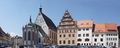
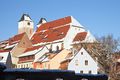
فرايبرگ أو فرايبرغ Freiberg هي بلدة جامعية وبلدة تعدين سابقة في ولاية ساكسونيا الحرة، ألمانيا. وهي ما يُدعى Große Kreisstadt (بلدة مقاطعة كبرى) والمركز الاداري لمنطقة ساكسونيا الوسطى.
وُضِع مركزها التاريخي تحت الحفاظ التراثي ورُشـِّح ليصبح موقع تراث عالمي لليونسكو، بإسم منطقة تعدين جبال الخامات. وحتى 1969، هيمنت على اقتصاد البلدة لنحو 800 عام صناعات التعدين والصهر. في العقود الأخيرة، أعيد تنظيمها لتصبح موقع تكنولوجيا متقدمة في مجالات صناعة أشباه الموصلات والتكنولوجيا الشمسية، كجزء من ساكسونيا السليكون. وهي مقر أقدم جامعة للتعدين وعلم المعادن في العالم - جامعة فرايبرگ للتعدين والتكنولوجيا.
فرايبرگ أو أم مدن التعدين في ساكسونيا ما كانت لتنشأ لولا اكتشاف الفضة في أرضها في حوالي القرن الثاني عشر الميلادي. حفز الاكتشافُ القاصي والداني لإنضاء ركاب طلب الفضة طمعًا في الثروة الموعودة. في المدينة تكدست الثروات وعند حكامها تصاعدت الرغبات في الكنائس المزخرفات. بالأموال المكنوزة قيض لهم استجلاب الحرفيين المهرة والبنائين واصحاب الصنايع ( ذات الامر حدث في درسدن حين استجلب حكامُها الإيطاليين كي يمتثلوا لهم المدنَ الايطالية). فلم تكن نهضتها إلا بالأموال الفائضة لا بإقصاء الكنسية ابتداءًا. هجرة أرباب الحرف والصنائع كانت الحافز الاول. كرة الثلج مرت هنا اولًا. تشبيه فرايبرگ بدبي اقترحه معماري ألماني: فرايبرگ صنعتها الفضة ودبي صنعها النفط.
الجغرافيا
الموقع
The town lies on the northern declivity of the Ore Mountains, with the majority of the borough west of the Eastern or Freiberger Mulde river. Parts of the town are nestled in the valleys of Münzbach and Goldbach streams. Its centre has an altitude of about 412 m above NHN (at the railway station). Its lowest point is on Münzbach on the town boundary at 340 m above NHN; its highest point is on an old mining tip at 491 m above NHN. Freiberg lies within a region of old forest clearances, subsequently used by the mining industry which left its mark on the landscape. The town is surrounded to the north, southeast and southwest by woods, and in the other directions by fields and meadows. Since the beginning of the 21st century an urbanised area has gradually developed which is formed by the towns of Nossen, Roßwein, Großschirma, Freiberg and Brand-Erbisdorf. It has currently about 75,000 inhabitants.
Freiberg is located about 31 كيلومتر (19 ميل) west-southwest of Dresden, about 31 kilometres east-northeast of Chemnitz, about 82 كيلومتر (51 ميل) southeast of Leipzig, and about 179 كيلومتر (111 ميل) south of Berlin and about 120 كيلومتر (75 ميل) northwest of Prague.
Freiberg lies on a boundary between two variants of the Saxon dialect: the Southeast Meissen dialect (Südostmeißnisch) to the east and the South Meissen dialect (Südmeißnisch) to the west of the town, both belonging to the five Meissen dialects, as well as just north of the border of the dialect region of East Erzgebirgisch.
توسع البلدة
The nucleus of the town, the former forest village of Christiansdorf lies in the valley of the Münzbach stream. The unwalled town centre grew up on its two slopes and on the ridge to the west. This means inter alia that the roads radiating outwards east of the old main road axis (today Erbische Straße and Burgstraße running from the former Erbisch Gate (Erbischer Tor) on Postplatz to Freudenstein Castle), some of which run as far as the opposite side of the Münzbach valley, are very steep. The area located east of the main road axis is called Unterstadt ("Lower Town"), with its lower market or Untermarkt. The western area is the Oberstadt ("Upper Town") where the Obermarkt or "Upper Market" is situated. The town centre is surrounded by a green belt running along the old town wall. In the west, this belt, in which the ponds of the Kreuzteichen are set, broadens out into an area like a park. Just north of the town centre, is Freudenstein Castle as well as the remnants of the town wall with several wall towers and Schlüsselteich pond in front of them. The remains of the wall run eastwards, in sections, to the Donats Tower. This area is dominated by the historic moat. The southern boundary of the old town is characterised in places by buildings from the Gründerzeit period. The B 101 federal road, here called Wallstraße, flanks the west of the town centre, the B 173, as Schillerstraße and Hornstraße, bounds it to the south.
Freiberg's north is dominated by the campus of its University of Mining and Technology. The main part of the campus on either side of Leipziger Straße (as the B 101 road, the most important transport link in this district) emerged in the 1950s and 1960s. Furthermore, the districts of Lossnitz, Lößnitz and Kleinwaltersdorf are found here, extending almost out to the boundary of the borough. Between Kleinwaltersdorf and Lößnitz is the Nonnenwald wood, and east of Leipziger Straße is a trading estate.

المنطقة المحيطة

In the area around Freiberg there are both industrial estates as well as agricultural and recreational areas. Smelting and metalworking firms are based at Muldenhütten and Halsbrücke and paper manufacturers at Weißenborn and Großschirma. Northeast of the town is the recreational area of the Tharandt Forest
The town of Großschirma lies north of Freiberg on the B 101 federal road. To the northeast the municipality of Halsbrücke borders on the territory of Freiberg's borough and, to the east, is the municipality of Bobritzsch-Hilbersdorf. The municipality of Weißenborn to the southeast belongs to the Verwaltungsgemeinschaft of Lichtenberg/Erzgebirge. On the B 101 south of Freiberg is the Große Kreisstadt of Brand-Erbisdorf and to the east is the municipality of Oberschöna.
أحياء البلدة والمناطق السكنية
|
|
|
التاريخ
![]() ساكسونيا 1423–1806
ساكسونيا 1423–1806
![]() مملكة ساكسونيا 1806–1871
مملكة ساكسونيا 1806–1871
![]() الإمبراطورية الألمانية 1871–1918
الإمبراطورية الألمانية 1871–1918
![]() جمهورية ڤايمار 1918–1933
جمهورية ڤايمار 1918–1933
![]() ألمانيا النازية 1933–1945
ألمانيا النازية 1933–1945
![]() ألمانيا 1945–1949
ألمانيا 1945–1949
![]() ألمانيا الشرقية 1949-1990
ألمانيا الشرقية 1949-1990
تأسست البلدة في 1186 وأصبحت مركزاً لصناعة التعدين في Ore Mountains for centuries. A symbol of that history is the Freiberg University of Mining and Technology, often just known as the Mining Academy (Bergakademie), established in 1765 and the second oldest university of mining and metallurgy in the world. (In North Hungary, in Selmecbánya town /now Banská Štiavnica, Slovakia/ a Mining Academy was established at 1735) Freiberg also has a notable cathedral containing two famous Gottfried Silbermann organs. There are two other organs made by Gottfried Silbermann – one at the St. Peter's Church (Petrikirche) and the other one at the St. James' Church (Jakobikirche). The medieval part of Freiberg stands under heritage protection.
The river, Freiberger Mulde, flows through the borough of Freiberg, but not the town itself.
In 1944, a subcamp of Flossenbürg concentration camp, was built outside the town of Freiberg. It housed over 500 female survivors of other camps, including Auschwitz Birkenau. Altogether 50 or so SS women worked in this camp until its evacuation in April 1945. The female survivors eventually reached Mauthausen concentration camp in Austria.
In 1985, Mormons built the Freiberg Germany Temple here because of the large number of members in the region. The Freiberg Germany Temple serves Mormons from all over Eastern Germany and a majority of Eastern Europe.
في 6 يوليو 2019، أُدرِجت منطقة Erzgebirge/Krušnohoří للتعدين والتي تضم فرايبرغ موقعاً للتراث عالمي حسب اليونسكو.
مناسبات منتظمة
Every year in Freiberg the Mining Town Festival (Bergstadtfest) is held on the last weekend in June with a procession by the historic Miners' and Ironworkers' Guilds, the so-called Miners' and Ironworkers' Parade. The Freiberg Christmas Market takes place during Advent, when a so-called Mettenschicht is held with a parade by the Miners' and Ironworkers' Guilds and the SAXONIA Miners Music Corps. This includes a traditional sermon on the mount in St. Peter's Church and waiting by the miners on the second Saturday in Advent. Firmly established is the potter's gathering on a weekend in the second half of April on the Upper Market (Obermarkt). Every year on the Drei Brüder Schacht mineshaft in the quarter of Zug there is a model steam engine gathering. Other annual events include the Freiberg Art Award and the election of the Mining Town Queen (Bergstadt-Königin).
التعليم
The Technische Universität Bergakademie Freiberg (Freiberg University of Mining and Technology or Freiberg Mining Academy, University of Technology) was established in 1765 by Prince Franz Xaver, regent of Saxony, based on plans by Friedrich Wilhelm von Oppel and Friedrich Anton von Heynitz, and is the oldest university of mining and metallurgy in the world.
معرض الصور
Untermarkt (Under Market)
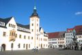
Obermarkt (Upper Market) with Town hall
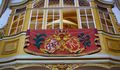
The electoral box of the Polish king Augustus II the Strong in the Freiberg Cathedral
St. Petri church
St. Nikolas church
Campus of the TU Bergakademie Freiberg
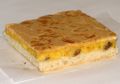
A Freiberg Eierschecke cake


العلاقات الدولية
البلدات التوأم – المدن الشقيقة
 Clausthal-Zellerfeld, Germany
- Darmstadt, Germany, since 1990
 Delft, Netherlands
 Gentilly, France
 Ness Ziona, Israel
 Příbram, Czech Republic
 Wałbrzych, Poland, since 1991
أحرار
- 2000 Günter Blobel, biochemist, Nobel Prize 1999
- 2014 Michael Federmann, investor
مواليد البلدة

- Günter Bartusch (1943–1971), motorcycle racer
- Rolf Emmrich (1910–1974), internist and university teachers
- Friedrich Robert Helmert (1843–1917), surveyor, mathematician, the Helmert transformation is named after him, it is the chi-squared distribution attributed
- Edward Johnson (1840–1903), local historian and editor of the Vogtländische Gazette
- Christian Heinrich Spiess (1755–1799), actor, playwright and author, co-founder of the Gothic novel
- Emil von Sydow (1812–1873) officer, geographer and cartographer
- André Tanneberger (born 1973), known as ATB, trance DJ
- Jakob Ullmann (born 1958), composer and university lecturer
- Clemens Winkler (1838–1904), chemist, discoverer of germanium
- Jacobo Benjamin Wiesner (1758-1842), metallurgist, expand the mining practices to Latin America, economic supporter of Colombian independence.
شخصيات عملت في فرايبرگ


- August Bebel (1840–1913), politician
- Fritz Bleyl (1880–1966) architect, painter of Expressionism
- گونتر بلوبل (مواليد 1936)، عالم أحياء، حصل على جائزة نوبل، متبني مقترح إعادة بناء مباني التاريخ الحديث في ساكسونيا.
- Kwasi Boakye (1827–1904), from Ashanti, Dutch mining engineer, student in Freiberg (also: Boachi)
- Johann Friedrich August Breithaupt (1791–1873), mineralogist
- ليوپولد فون بوخ (1774–1853)، جيولوجي
- Hans Carl von Carlowitz (1645–1714), Saxon Oberberg Chief
- Christoph Demantius (1567–1643), composer
- يوهان ڤولفگانگ فون گوته (1749–1832)، عالم طبيعي وكاتب ورجل دولة
- ألكسندر فون هومبولت (1769–1859)، عالم طبيعيات ومستكشف
- Herbert Jobst (1915–1990), writer
- Helmut Kirchberg (1906–1983), mining scientist
- Theodor Körner (author) (1791–1813), poet, freedom fighter
- Wilhelm August Lampadius (1772–1842), metallurgist, chemist
- فريدرش موز (1773–1839)، عالم معادن، وخالق Mohssche Härteskala
- Carl Friedrich Naumann (1797–1873)، جيولوجي
- نوڤاليس (1772–1801)، شاعر
- Max Roscher, (1888–1940), politician, Reichstag deputy
- Bernd Schröder (born 1942), football coach
- Clara Schumann (1819–1896), pianist
- Gottfried Silbermann (1683–1753), organ builders
- Alfred Wilhelm Stelzner (1840–1895), geologist
- Robert Volkmann (1815–1883), composer
- Christian Leopold von Buch (1774–1853), geologist
- Bernhard von Cotta (1808–1879), geologist
- Kunz von Kaufungen (1410–1455), abductor of the Saxon Princes Albrecht and Ernst, executed in Freiberg
- Eberhard Wächtler (1929–2010), economic historian
- Julius Weisbach (1806–1871), mathematician and engineer
- ابراهام گوتلوب ڤرنر (1749–1817)، أحد مؤسسي علوم الأرض الحديثة
- Johann Heinrich Zedler (1706 to 1751), bookseller and publisher
- Gustav Zeuner (1828–1907), engineer
الهامش والملاحظات
- ^ "Städtepartnerschaften". freiberg.de (in الألمانية). Freiberg. Retrieved 30 November 2019.
- Cziborra, Pascal. KZ Freiberg. Geheime Schwangerschaft. Lorbeer Verlag. Bielefeld. 2008. ISBN 978-3-938969-05-2
وصلات خارجية
 Media related to Freiberg (Sachsen) at Wikimedia Commons
- Official website
- Pages using gadget WikiMiniAtlas
- CS1 الألمانية-language sources (de)
- Short description is different from Wikidata
- Coordinates on Wikidata
- Germany articles requiring maintenance
- Pages using infobox German location with unknown parameters
- Towns in Saxony
- فرايبرغ
- Towns in the Ore Mountains
- Mittelsachsen
- مملكة ساكسونيا
- Bezirk Karl-Marx-Stadt
- Mining communities in Germany