ساكسونيا
| Freistaat Sachsen (بالألمانية) Swobodny stat Sakska (بالسوربية) ولاية سكسونيا الحرة | |||
| العلم | الدرع | ||
| |||
| الموقع | |||
| |||
| الاحداثيات | 51°2′N 13°21′E / 51.033°N 13.350°E | ||
| منطقة التوقيت | CET/CEST (UTC+1/+2) | ||
| الادارة | |||
| الدولة | |||
| NUTS Region | |||
| العاصمة | درسدن | ||
| أكبر مدينة | لايپتسيگ | ||
| الوزير-الرئيس | Georg Milbradt (CDU) | ||
| Governing parties | CDU / SPD | ||
| Votes in Bundesrat | 4 (of 69) | ||
| الاحصائيات الأساسية | |||
| المساحة | 18٬416 كم² (7٬110 ميل مربع) | ||
| التعداد | 4٬252٬000 (11/2006)[1] | ||
| - الكثافة | 231 /كم² (598 /sq mi) | ||
| معلومات أخرى | |||
| GDP/ الاسمي | € 86 بليون (2005) | ||
| موقع الكتروني | sachsen.de | ||
ساكسونيا هي احدى ولايات ألمانيا الستة عشر. كانت قبل الوحدة الألمانية احدى أهم ولايات جمهورية ألمانيا الديمقراطية.
سكسونيا Sachsen ولاية ألمانية، تقع شرقي البلاد، عاصمتها درسدن، يحدها من الشرق بولندا، ومن الجنوب جمهورية تشيكيا، ومن الشمال ولايتا برلين وسكسونيا أنهالت، ومن الغرب ولاية تورنگن. تبلغ مساحتها 18,413 كم2. يخترقها نهر الإلبه، أهم جبالها جبال هارتس Harz، يبلغ أقصى ارتفاع فيها 1215م، أصول سكانها من السكسون عددهم 4.5 مليون نسمة، تضم الولاية ثلاث محافظات هي درسدن ولايپزيگ Leipzig وخمنيتس Chemnitz (كانت تدعى في المدة من 1960 حتى 1990 بمدينة كارل ماركس)، تبلغ الكثافة السكانية فيها 244 نسمة/كم2، وهي من أغنى الولايات الألمانية الجديدة (بعد الوحدة) بالسكان. (كانت سكسونيا قبل الحرب العالمية الثانية قلب ألمانيا الصناعي، وأصبحت بعدها من أهم مناطق ألمانيا الديمقراطية على جميع الأصعدة الثقافية والصناعية والسياحية وغيرها). وقد حدث تحول كبير في هيكلة القطاعات بعد الوحدة الألمانية، إذ يعمل اليوم نحو 60% من سكان الولاية في قطاع الخدمات. ومع ذلك فهي تلعب دوراً لا بأس به في الصناعة الألمانية، إذ تنتج 33% من الإنتاج الصناعي للولايات الجديدة. وأهم صناعاتها الصناعات الغذائية وصناعة الآلات التقليدية واستخراج المعادن وتصنيعها وصناعة السيارات وصناعة أجهزة معالجة البيانات. ومنذ عام 1710 تنتج مدينة مايسن في الولاية أشهر أنواع الخزف في العالم.
التعليم
تشتهر سكسونيا بكثرة جامعاتها ومعاهدها وتنوع الاختصاصات فيها، هناك أربع جامعات: جامعة لايبزج وجامعة فرايبورگ وجامعة درسدن وجامعة خمنيتس، وفيها اثني عشر معهداً عالياً للتقانة وخمسة معاهد للفنون، من بينها المعهد الدولي في تسيتاو Zittau وأكاديمية الرقص الفني (مدرسة بالوكا في درسدن) فهي أكثر الولايات الشرقية تنوعاً وغنىً ثقافياً.
الجغرافيا
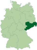
تقع ساكسونيا في شرق ألمانيا. لها حدود مشتركة مع بولندا وجمهورية التشيك. كما يحد الولاية كل من براندنبورگ، ساكسونيا السفلى وتورنگن.
أهم المرتفعات بالولاية هم جبال ارز و جبال زيتاو و مرتفعات سويسرا الساكسونية. أهم وأعرض و النهر الوحيد الصالح للملاحة هو الإلبه.
التقسيم السياسي وأهم المدن
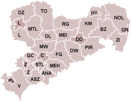
تقسم الولاية إلى 22 دائرة قروية و7 دوائر مدنية.
|
|
|
Furthermore there are seven independent cities (ألمانية: Kreisfreie Städte / Stadtkreise), which don't belong to any district:
لايبزگ هي أكبر مدينة بالولاية، عدد سكانها يبلغ 495000 نسمة. دريسدن العاصمة يبلغ عدد سكانها 480000 نسمة.
أهم المدن الأخرى: خمنيتس وتسڤيكاو، .
ولاية سكسونيا الداخلية (سكسونيا أنهالت)
تقع في وسط ألمانيا عاصمتها ماگدبورگ. ويبلغ عدد سكانها 2.65 مليون نسمة ومساحتها 20455 كم2، أهم مدنها العاصمة التي يبلغ عدد سكانها 239000 نسمة، وفيها أول كاتدرائية قوطية بُنيت في ألمانيا، أما مدينة هالة Halle فعدد سكانها 261000 نسمة، اشتهرت في العصور الوسطى باستخراج الملح، وفي وسطها ثلاثة معالم مهمة هي الكاتدرائية وكنيسة السوق، والبرج الأحمر.
تشتهر ولاية سكسونيا أنهالت بمناظرها الطبيعية الخلابة إضافة إلى أنها منطقة زراعية مهمة، أراضيها من أخصب الأراضي الزراعية في ألمانيا، أهم صناعاتها هي الصناعات الكيمياوية والصناعات الغذائية.
ولاية سكسونيا السفلى Niedersachsen
تقع في شمالي ألمانيا، عاصمتها هانوفر Hannover، عدد سكانها 7.8 مليون نسمة ومساحتها 47338 كم2، وهي بذلك ثاني أكبر ولاية في ألمانيا.
أهم مدنها العاصمة التي يبلغ عدد سكانها 516000 نسمة، وهي من أكثر المدن جذباً للسياح، إذ تتوافر فيها الكثير من المناطق الطبيعية الخلابة، وهي مركز للصناعة ويقام فيها أهم المعارض الصناعية، ومدينة براونشفايغ Brunswick وعدد سكانها 247000 نسمة.
تؤلف الأراضي الزراعية ثلثي مساحة الولاية ومنتوجات الصناعات الغذائية شديدة التنوع.
الاقتصاد والبنية التحتية
تتمتع ساكسونيا بأعلى نسبة نمو اقتصادي بين ولايات ألمانيا، حيث تبلغ بين 8-10%. هذا لا يمنع من وجود نسبة عالية من البطالة كباقي مثيلاتها بشرق ألمانيا.
الحكومة الألمانية تستثمر باستمرار في البنية التحتية بالولاية. يوجد مطارات دولية بلايبزغ و دريسدن.
التاريخ
Saxony has a long history as a duchy, an electorate of the Holy Roman Empire (the Electorate of Saxony), and finally as a kingdom (the Kingdom of Saxony). In 1918, after Germany's defeat in World War I, its monarchy was overthrown and a republican form of government was established under the current name. The state was broken up into smaller units during communist rule (1949–1989), but was re-established on 3 October 1990 on the reunification of East and West Germany.
Prehistory
In prehistoric times, the territory of present-day Saxony was the site of some of the largest of the ancient central European monumental temples, dating from the fifth century BC. Notable archaeological sites have been discovered in Dresden and the villages of Eythra and Zwenkau near Leipzig. The Germanic presence in the territory of today's Saxony is thought to have begun in the first century BC.
Parts of Saxony were possibly under the control of the Germanic King Marobod during the Roman era. By the late Roman period, several tribes known as the Saxons emerged, from which the subsequent state(s) draw their name.
Stem Duchy of Saxony
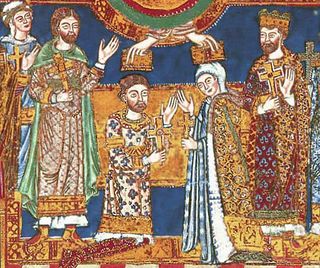
The first medieval Duchy of Saxony was a late Early Middle Ages "Carolingian stem duchy", which emerged around the start of the 8th century AD and grew to include the greater part of Northern Germany, what are now the modern German states of Bremen, Hamburg, Lower Saxony, North Rhine-Westphalia, Schleswig-Holstein and Saxony-Anhalt. Saxons converted to Christianity during this period, with Charlemagne outlawing pagan practices.[2] This geographical region is unrelated to present-day Saxony but the name moved southwards due to certain historical events (see below).
The territory of the Free State of Saxony, called White Serbia was, since the 6th century, populated by Slavs before being conquered by Germans e.g. Saxons and Thuringii. It was not part of the old Saxon stem duchy. A legacy of this period is the Sorb population in Saxony. Eastern parts of present Saxony were ruled by Poland between 1002 and 1032 and by Bohemia since 1293.
Holy Roman Empire
The territory of the Free State of Saxony became part of the Holy Roman Empire by the 10th century, when the dukes of Saxony were also kings (or emperors) of the Holy Roman Empire, comprising the Ottonian, or Saxon, Dynasty. Around this time, the Billungs, a Saxon noble family, received extensive lands in Saxony. The emperor eventually gave them the title of dukes of Saxony. After Duke Magnus died in 1106, causing the extinction of the male line of Billungs, oversight of the duchy was given to Lothar of Supplinburg, who also became emperor for a short time.
The Margravate of Meissen was founded in 985 as a frontier march, that soon extended to the Kwisa (Queis) river to the east and as far as the Ore Mountains. In the process of Ostsiedlung, settlement of German farmers in the sparsely populated area was promoted.
In 1137, control of Saxony passed to the Guelph dynasty, descendants of Wulfhild Billung, eldest daughter of the last Billung duke, and the daughter of Lothar of Supplinburg. In 1180 large portions west of the Weser were ceded to the Bishops of Cologne, while some central parts between the Weser and the Elbe remained with the Guelphs, becoming later the Duchy of Brunswick-Lüneburg. The remaining eastern lands, together with the title of Duke of Saxony, passed to an Ascanian dynasty (descended from Eilika Billung, Wulfhild's younger sister) and were divided in 1260 into the two small states of Saxe-Lauenburg and Saxe-Wittenberg. The former state was also named Lower Saxony, the latter Upper Saxony, thence the later names of the two Imperial Circles Saxe-Lauenburg and Saxe-Wittenberg. Both claimed the Saxon electoral privilege for themselves, but the Golden Bull of 1356 accepted only Wittenberg's claim, with Lauenburg nevertheless continuing to maintain its claim. In 1422, when the Saxon electoral line of the Ascanians became extinct, the Ascanian Eric V of Saxe-Lauenburg tried to reunite the Saxon duchies.
However, Sigismund, King of the Romans, had already granted Margrave Frederick IV the Warlike of Meissen (House of Wettin) an expectancy of the Saxon electorate in order to remunerate his military support. On 1 August 1425 Sigismund enfeoffed the Wettinian Frederick as Prince-Elector of Saxony, despite the protests of Eric V. Thus the Saxon territories remained permanently separated.
The Electorate of Saxony was then merged with the much larger Wettinian Margraviate of Meissen; however, it used the higher-ranking title Electorate of Saxony and even the Ascanian coat-of-arms for the entire monarchy.[3] Thus Saxony came to include Dresden and Meissen. Hence, the territory of the modern Free State of Saxony shares the name with the old Saxon stem duchy for historical and dynastic reasons rather than any significant ethnic, linguistic or cultural connection. In the 18th and 19th centuries Saxe-Lauenburg was colloquially called the Duchy of Lauenburg, which was held in a personal union by the Electorate of Hanover from the 18th century to the Napoleonic wars, and in a personal union with Denmark (along with neighbouring Holstein and Schleswig) for much the 19th century. In 1876 it was absorbed into Prussia as the Duchy of Lauenburg district of the Province of Schleswig-Holstein).
تأسيس ثاني دولة ساكسونية
Saxe-Wittenberg, mostly in modern Saxony-Anhalt, became subject to the margravate of Meissen, ruled by the Wettin dynasty in 1423. This established a new and powerful state, occupying large portions of the present Free State of Saxony, Thuringia, Saxony-Anhalt and Bavaria (Coburg and its environs). Although the centre of this state was far to the southeast of the former Saxony, it came to be referred to as Upper Saxony and then simply Saxony, while the former Saxon territories in the north were now known as Lower Saxony (the modern term Niedersachsen deriving from this).
In 1485, Saxony was split in the Treaty of Leipzig. A collateral line of the Wettin princes received what later became Thuringia and founded several small states there (see Ernestine duchies). Since these princes were allowed to use the Saxon coat of arms, in many towns of Thuringia, the coat of arms can still be found on historical buildings.
The remaining Saxon state became still more powerful, also incorporating new territories and was known in the 18th century for its cultural achievements, although it was politically weaker than Prussia and Austria, states which oppressed Saxony from the north and south, respectively.
Between 1697 and 1763, the Electors of Saxony were also elected Kings of Poland in personal union.
In 1756, Saxony joined a coalition of Austria, France and Russia against Prussia. Frederick II of Prussia chose to attack preemptively and invaded Saxony in August 1756, precipitating the Third Silesian War (part of the Seven Years' War). The Prussians quickly defeated Saxony and incorporated the Saxon army into the Prussian army. At the end of the Seven Years' War, Saxony recovered its independence in the 1763 Treaty of Hubertusburg.
19th century
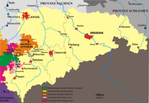
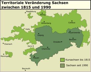
In 1806, French Emperor Napoleon abolished the Holy Roman Empire and established the Electorate of Saxony as a kingdom in exchange for military support. The Elector Frederick Augustus III accordingly became King Frederick Augustus I of Saxony. Frederick Augustus remained loyal to Napoleon during the wars that swept Europe in the following years; he was taken prisoner and his territories declared forfeit by the allies in 1813, after the defeat of Napoleon. Prussia intended the annexation of Saxony but the opposition of Austria, France, and the United Kingdom to this plan resulted in the restoration of Frederick Augustus to his throne at the Congress of Vienna although he was forced to cede the northern part of the kingdom to Prussia, which led to the loss of nearly 50% of the Saxon territory.[4] Most of these lands were merged with the Duchy of Magdeburg, the Altmark and some smaller territories to become the Prussian Province of Saxony, a predecessor of the modern state of Saxony-Anhalt. Lower Lusatia and part of the former Saxe-Wittenberg territory became part of the Province of Brandenburg and the northeastern part of Upper Lusatia became part of the Province of Silesia. The rump Kingdom of Saxony had roughly the same extent as the present state, albeit slightly smaller.
Meanwhile, in 1815, the southern part of Saxony, now called the "State of Saxony" joined the German Confederation.[5] The German Confederation should not be confused with the North German Confederation mentioned below. This southern Saxony shaped the territory of modern Saxony. In the politics of the Confederation, Saxony was overshadowed by Prussia. King Anthony of Saxony came to the throne of Saxony in 1827. Shortly thereafter, liberal pressures in Saxony mounted and broke out in revolt during 1830—a year of revolution in Europe.[5] The revolution in Saxony resulted in a constitution for the State of Saxony that served as the basis for its government until 1918.[5]
During the 1848–49 constitutionalist revolutions in Germany, Saxony became a hotbed of revolutionaries, with anarchists such as Mikhail Bakunin and democrats including Richard Wagner and Gottfried Semper taking part in the May Uprising in Dresden in 1849. (Scenes of Richard Wagner's participation in the May 1849 uprising in Dresden are depicted in the 1983 movie Wagner starring Richard Burton as Richard Wagner.) The May uprising in Dresden forced King Frederick Augustus II of Saxony to concede further reforms to the Saxon government.[5]
In 1854 Frederick Augustus II's brother, King John of Saxony, succeeded to the throne. A scholar, King John translated Dante.[5] King John followed a federalistic and pro-Austrian policy throughout the early 1860s until the outbreak of the Austro-Prussian War. During that war, Prussian troops overran Saxony without resistance and then invaded Austrian (today's Czech) Bohemia.[6] After the war, Saxony was forced to pay an indemnity and to join the North German Confederation in 1867.[7] Under the terms of the North German Confederation, Prussia took over control of the Saxon postal system, railroads, military and foreign affairs.[7] In the Franco-Prussian War of 1870, Saxon troops fought together with Prussian and other German troops against France.[7] In 1871, Saxony joined the newly formed German Empire.[7]
20th century
After King Frederick Augustus III of Saxony abdicated on 13 November 1918, Saxony, remaining a constituent state of Germany (Weimar Republic), became the Free State of Saxony under a new constitution enacted on 1 November 1920. In October 1923 the federal government under Chancellor Gustav Stresemann overthrew the legally elected SPD-Communist coalition government of Saxony. The state retained its name and borders during the Nazi era as a Gau (Gau Saxony), but lost its quasi-autonomous status and its parliamentary democracy.
During the war, under the secret Nazi programme Aktion T4, an estimated 15,000 people suffering from mental and physical disabilities, as well as a number of concentration camp inmates, were murdered at Sonnenstein killing centre near Pirna.
As World War II drew to its end, U.S. troops under General George Patton occupied the western part of Saxony in April 1945, while Soviet troops occupied the eastern part. That summer, the entire state was handed over to Soviet forces as agreed in the London Protocol of September 1944. Britain, the US, and the USSR then negotiated Germany's future at the Potsdam Conference. Under the Potsdam Agreement, all German territory East of the Oder-Neisse line was annexed by Poland and the Soviet Union, and, unlike in the aftermath of World War I, the annexing powers were allowed to expel the inhabitants. During the following three years, Poland and Czechoslovakia forcibly expelled German-speaking people from their territories, and some of these expellees came to Saxony. Only a small area of Saxony lying east of the Neisse River and centred around the town of Reichenau was annexed by Poland. Traditional close relations of Saxony with neighbouring German-speaking Egerland was thus completely destroyed, making the border of Saxony along the Ore Mountains a linguistic border.
Part of the former Prussian province of Lower Silesia lay west of the Oder-Neisse line and therefore was separated from the bulk of its former province; the Soviet Military Administration in Germany (SVAG) merged this territory into Saxony.[8] This former Silesian territory broadly corresponded with the Upper Lusatian territory annexed by Prussia in 1815.
On 20 October 1946, SVAG organised elections for the Saxon state parliament (Landtag), but many people were arbitrarily excluded from candidacy and suffrage, and the Soviet Union openly supported the Socialist Unity Party of Germany (SED). The new minister-president Rudolf Friedrichs (SED), had been a member of the SPD until April 1946. He met his Bavarian counterparts in the U.S. zone of occupation in October 1946 and May 1947, but died suddenly in mysterious circumstances the following month. He was succeeded by Max Seydewitz, a loyal follower of Joseph Stalin.[citation needed]
The German Democratic Republic (East Germany), including Saxony, was established in 1949 out of the Soviet zone of Occupied Germany, becoming a constitutionally socialist state, part of COMECON and the Warsaw Pact, under the leadership of the SED. In 1952 the government abolished the Free State of Saxony, and divided its territory into three Bezirke: Leipzig, Dresden, and Karl-Marx-Stadt (formerly and currently Chemnitz). Areas around Hoyerswerda were also part of the Cottbus Bezirk.
The Free State of Saxony was reconstituted with slightly altered borders in 1990, following German reunification. Besides the formerly Silesian area of Saxony, which was mostly included in the territory of the new Saxony, the free state gained further areas north of Leipzig that had belonged to Saxony-Anhalt until 1952.
التعليم و الثقافة
اللغة
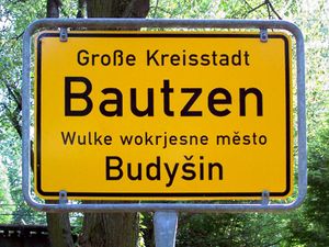
اللهجة الساكسونية هي أحد أشهر اللهجات باللغة الألمانية.
يوجد في الولاية عدة جامعات و العديد من المعاهد التطبيقية.
المصادر
- ^ "State population". Portal of the Federal Statistics Office Germany. Retrieved 2007-04-25.
- ^ Karras, Ruth Mazo (1986). "Pagan Survivals and Syncretism in the Conversion of Saxony". The Catholic Historical Review. 72 (4): 553–572. ISSN 0008-8080.
- ^ The Ascanian coat-of-arms shows the Ascanian barry of ten, in sable and or, covered by a crancelin of rhombs bendwise in vert.
- ^ Pollock & Thomas (1952), p. 486
- ^ أ ب ت ث ج Pollock & Thomas (1952), p. 510
- ^ Pollock & Thomas (1952), pp. 510–511
- ^ أ ب ت ث Pollock & Thomas (1952), p. 511
- ^ Kosiński, Leszek (1960) "Pochodzenie terytorialne ludności Ziem Zachodnich w 1950 r. [Territorial origins of inhabitants of the Western Lands in year 1950]" (PDF). Dokumentacja Geograficzna (in Polish). Warsaw: PAN (Polish Academy of Sciences), Institute of Geography. 2: Tabela 1 (data by county) – via Repozytorium Cyfrowe Instytutów Naukowych.


