جبل القديس ميشل
| جبل سان ميشل وخليجه Mont-Saint-Michel and its Bay | |
|---|---|
 | |
| أسس الاختيار | ثقافي: i, iii, vi |
| المراجع | 80 |
| Inscription | 1979 (3rd Session) |
| Coordinates | 48°38′08″N 1°30′40″W / 48.63556°N 1.51111°W |

جبل القديس ميشل هو جزيرة حجرية صغيرة في نورماندي، تبعد حوالي الكيلومتر عن ساحل فرنسا، تعد القلعة والكنيسة المبنية عليها ثالث أكثر الأماكن السياحة من حيث عدد السياح في فرنسا بعد برج إيفل وقصر ڤرساي.
جزيرة جزْر

تاريخ


التطور
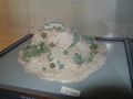
10th century
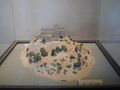
11th to 12th century
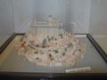
17th to 18th century
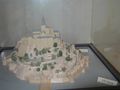
20th century


التصميم

Plan of the mount by Eugène Viollet-le-Duc
المد والجزر

The tides in the area change quickly, and have been described by Victor Hugo as "à la vitesse d'un cheval au galop" or "as swiftly as a galloping horse".


المصادر
انظر أيضاً
وصلات خارجية
مشاع المعرفة فيه ميديا متعلقة بموضوع Mont-Saint-Michel.
- جبل القديس ميشل travel guide from Wikitravel
- Official Mont-Saint Michel Tourist site (English version)
| إيل دو فرانس |
| |
|---|---|---|
| الحوض الپاريسي | ||
| أراضي كاليه الشمالية | ||
| الشرق |
| |
| الغرب | ||
| الجنوب الغربي | ||
| الشرق-الوسط | ||
| البحر المتوسط |
| |
| أقاليم متعددة | ||
| الأقسام والمناطق وراء البحار | ||
| ||
This article contains content from Wikimedia licensed under CC BY-SA 4.0. Please comply with the license terms.