تشيهيرين
تشيهيرين
Чигирин Chyhyryn | |
|---|---|
 View of Chyhyryn. | |
 Flag  Coat of arms | |
 تشيهيرين Location of Chyhyryn  تشيهيرين تشيهيرين (أوكرانيا) | |
| Coordinates: 49°04′38″N 32°38′57″E / 49.07722°N 32.64917°E | |
| البلد | |
| الأوبلاست | |
| الرايون | رايون تشركاسي |
| حقوق المدينة | 1592 |
| Government | |
| • Mayor | Serhiy Oleksiiovych Tymchenko |
| Area | |
• Total | 14 كم² (5 ميل²) |
| Elevation | 124 m (407 ft) |
| Population (2021) | |
• Total | 8٬664 |
| • Density | 854/km2 (2٬210/sq mi) |
| Postal code | 20900-20906 |
| Area code | +380 4730 |
تشيهيرين (أوكرانية: Чигири́н؛ تـُنطق [tʃɪɦɪˈrɪn] ؛ Chyhyryn) هي مدينة وموقع تاريخي في رايون تشركاسي في أوبلاست تشركاسي في وسط أوكرانيا. From 1648 to 1669 the city was a Hetman residence. After a forced relocation of the Ruthenian Orthodox metropolitan see from Kyiv in 1658, it became a full-fledged capital of the Cossack Hetmanate. Chyhyryn also became a traditional place for the appointment to the office of Hetman of Zaporizhian Host. It hosts the administration of Chyhyryn urban hromada, one of the hromadas of Ukraine.[1] Population: 8٬664 (2021 est.)[2]
الأسماء
Chyhyryn (أوكرانية: Чигирин) or Chigirin (روسية: Чигири́н) پولندية: Czehryń, بالتركية: Çigirin أو Çehrin.
الموقع
The city is on the banks of Tiasmyn River and lies at an altitude of 124 metres above mean sea level. Minor industries, such as food and furniture factories, are the basis of the town economy in the 21st century.
التاريخ
The area (1320–1569) had been part of the Grand Duchy of Lithuania. It was ceded to the Polish–Lithuanian Commonwealth (in the Kijów Voivodeship [Kyiv or Kiev] of the Crown of Poland) before the Union of Lublin. It was granted Magdeburg Rights in 1592 by Sigismund III Vasa.

Chyhyryn is first mentioned as a fortified Cossack winter station. In 1638, Bohdan Khmelnytsky became its starosta (regional leader), and in 1648 it became the newly elected Hetman's residence and the capital of the Cossack state, the Zaporozhian Host. During the Russo-Turkish War (1676–1681) it was the center of two bloody campaigns (1675–76 and 1677–78). In 1678 the castle of Chyhyryn was blown up by the retreating Russian garrison that was stationed there, while the Turkish forces sacked the rest of the city. After this, it gradually lost its significance. It remained the center of the Chyhyryn regiment until 1712 and upon the final incorporation into the Russian Empire (1793) it became part of the Kyiv region.
In 1917 a congress of Free Cossacks took place in Chyhyryn. At that congress by tradition Pavlo Skoropadsky was elected as the Hetman of the Cossacks (later in 1918 in Kyiv, he was elected the Hetman of Ukraine as well).
During World War II, Chyhyryn was occupied by the German Army from August 7, 1941 to December 12, 1943.
In 1989 the population of the city was 12 853 people.[3]
Until 18 July 2020, Chyhyryn served as an administrative center of Chyhyryn Raion. The raion was abolished in July 2020 as part of the administrative reform of Ukraine, which reduced the number of raions of Cherkasy Oblast to four. The area of Chyhyryn Raion was merged into Cherkasy Raion.[4][5]
المناخ
| بيانات المناخ لـ تشيهيرين (1981–2010) | |||||||||||||
|---|---|---|---|---|---|---|---|---|---|---|---|---|---|
| الشهر | ينا | فب | مار | أبر | ماي | يون | يول | أغس | سبت | أكت | نوف | ديس | السنة |
| متوسط القصوى اليومية °س (°ف) | −0.9 (30.4) |
−0.1 (31.8) |
5.5 (41.9) |
14.4 (57.9) |
21.3 (70.3) |
24.3 (75.7) |
26.3 (79.3) |
25.9 (78.6) |
20.0 (68.0) |
13.0 (55.4) |
5.0 (41.0) |
0.4 (32.7) |
12.9 (55.2) |
| المتوسط اليومي °س (°ف) | −3.5 (25.7) |
−3.1 (26.4) |
1.7 (35.1) |
9.4 (48.9) |
15.9 (60.6) |
19.2 (66.6) |
21.2 (70.2) |
20.4 (68.7) |
14.9 (58.8) |
8.8 (47.8) |
2.3 (36.1) |
−2.1 (28.2) |
8.8 (47.8) |
| متوسط الدنيا اليومية °س (°ف) | −6.1 (21.0) |
−5.9 (21.4) |
−1.5 (29.3) |
4.8 (40.6) |
10.4 (50.7) |
14.3 (57.7) |
16.1 (61.0) |
15.0 (59.0) |
10.4 (50.7) |
5.4 (41.7) |
−0.2 (31.6) |
−4.4 (24.1) |
4.9 (40.8) |
| متوسط تساقط الأمطار mm (inches) | 34.4 (1.35) |
32.9 (1.30) |
35.5 (1.40) |
36.7 (1.44) |
49.7 (1.96) |
77.1 (3.04) |
65.2 (2.57) |
54.2 (2.13) |
55.9 (2.20) |
42.1 (1.66) |
39.4 (1.55) |
37.0 (1.46) |
560.1 (22.05) |
| Average precipitation days (≥ 1.0 mm) | 7.4 | 7.1 | 7.3 | 7.0 | 7.2 | 8.5 | 7.1 | 6.3 | 6.5 | 5.7 | 6.8 | 7.4 | 84.3 |
| متوسط الرطوبة النسبية (%) | 83.5 | 80.8 | 76.6 | 66.9 | 63.2 | 68.0 | 68.0 | 66.4 | 71.9 | 76.9 | 84.0 | 85.1 | 74.3 |
| Source: World Meteorological Organization[6] | |||||||||||||
أبرز السكان
- Georgy Danilov، عالم لسانيات
المعالم
The Trinity Monastery, built near Chyhyryn in 1627, was later destroyed by the Soviet authorities. Other historical landmarks, such as the town hall and Khmelnytsky's palace, did not survive either. After Ukraine regained independence, Hetman's residence was restored and became a museum.
معرض صور
-
 Main square of Chyhyryn
 -
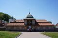 Entrance of the restored Bohdan Khmelnytskyi residence
 -
 Bohdan Khmelnytskyi residence
 -
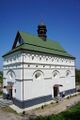 St. Peter and St. Paul Church in Chyhyryn
 -
 A statue near the church
 -
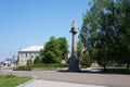
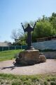
 Taras Shevchenko monument in Chyhyryn
 -
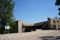
 View on Bohdan Khmelnytskyi Museum
 -
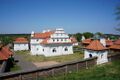
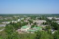
 View of Chyhyryn from the city's Castle Hill
 -
 Bohdan Khmelnytskyi monument in Chyhyryn


العلاقات الدولية
البلدات التوأم — المدن الشقيقة
تشيهيرين متوأمة مع:
| المدينة | البلد | سنة التوقيع |
|---|---|---|
| سباستوپول، كاليفورنيا | 1993 |
المراجع
- ^ "Чигиринська територіальна громада" (in الأوكرانية). decentralization.gov.ua.
- ^ "Чисельність наявного населення України (التعداد الفعلي لأوكرانيا)" (PDF) (in الأوكرانية). مصلحة إحصائيات الدولة الأوكرانية. Retrieved 11 July 2021.
- ^ Всесоюзная перепись населения 1989 г. Численность городского населения союзных республик, их территориальных единиц, городских поселений и городских районов по полу
- ^ "Про утворення та ліквідацію районів. Постанова Верховної Ради України № 807-ІХ". Голос України (in الأوكرانية). 2020-07-18. Retrieved 2020-10-03.
- ^ "Нові райони: карти + склад" (in Ukrainian). Міністерство розвитку громад та територій України.
{{cite web}}: CS1 maint: unrecognized language (link) - ^ "World Meteorological Organization Climate Normals for 1981–2010". World Meteorological Organization. Archived from the original on 17 July 2021. Retrieved 17 July 2021.
وصلات خارجية
- Chyhyryn in the Encyclopedia of Ukraine
- Soviet topographic map 1:100,000
 Media related to Chyhyryn at Wikimedia Commons
العواصم التاريخية لروس، والدول الأوكرانية والدول على الأراضي الأوكرانية1 | |||||||||
|---|---|---|---|---|---|---|---|---|---|
| الدول الأوكرانية القروسطية والحديثة المبكرة |
| ||||||||
| الدول الأوكرانية بعد الامبراطورية الروسية وقبل |أوكرانيا ج.ا.س. |
| ||||||||
| أوكرانيا ج.ا.س. (منذ 1919)، أوكرانيا المستقلة (منذ 1991) |
| ||||||||
1 تعني دول (للقوزاق) على أراضي أوكرانيا الحالية | |||||||||
- Pages using gadget WikiMiniAtlas
- CS1 الأوكرانية-language sources (uk)
- Short description is different from Wikidata
- Articles containing أوكرانية-language text
- Coordinates on Wikidata
- Pages using Lang-xx templates
- Articles containing روسية-language text
- Articles containing پولندية-language text
- مدن أوبلاست چركاسي
- Chigirinsky Uyezd
- ڤويڤودية كييڤ
- عواصم وطنية سابقة
- عواصم سابقة لأوكرانيا
- Cities of district significance in Ukraine
- هتمانية القوزاق