بلباو
بلباو بالإنجليزية Bilbao ، مدينة اسبانية تقع ضمن اقليم الباسك Basques في الشمال الشرقي لاسبانيا. وردت في المصادر العربية باسم (البشكنس) نسبة إلى اقوام وثنية كانت تسكن في تلك المناطق كانت مصر ازعاج للسلطات الرومانية ومن بعدها للسلطات الغوطية والعربية . حيث كانت في حالة تمرد مستمرة. بلغ عدد سكان المدينة في تقديرات 2006 354.145 نسمة ، وتعتبر أكثر مدن مقاطعة بلباو العظمى نشاطا من الناحية الإقتصادي والصناعية ، وهي المنطقة التي يسكن فيها أكثر من منصف عدد سكان إقليم الباسك. عدد سكان بلباو العظمى حوالي 946.829 نسمة ويقطنون على ضفتي نهر نيرفيون ، الذي يجاوره الكثير من المصانع والمشاريع ، وخلال الثورة الصناعية حدث إزدهار كبير للإقليم من خلال تلك النشاطات الاقتصادية.
بلباو | |
|---|---|
 Clockwise from top: Panorama from mount Artxanda, church of San Antón, Bilbao Guggenheim Museum, Fosterito, and Euskalduna Palace | |
 Flag .svg) Coat of arms | |
| الكنية: el botxo | |
 موقع بلباو في منطقة الباسك الذاتية | |
| الإحداثيات: 43°15′25″N 2°55′25″W / 43.25694°N 2.92361°WCoordinates: 43°15′25″N 2°55′25″W / 43.25694°N 2.92361°W | |
| البلد | |
| Autonomous community | |
| المقاطعة | بسكاي |
| كوماركا | بلباو الكبرى |
| Founded | 15 June 1300 |
| الحكومة | |
| • النوع | Mayor-Council |
| • Mayor | Iñaki Azkuna (PNV) |
| المساحة | |
| • Municipality | 40٫65 كم² (15٫70 ميل²) |
| • الحضر | 17٫35 كم² (6٫70 ميل²) |
| • الريف | 23٫30 كم² (9�00 ميل²) |
| المنسوب | 19 m (62 ft) |
| أعلى منسوب | 689 m (2٬260 ft) |
| أوطى منسوب | 0 m (0 ft) |
| التعداد (2010) | |
| • Municipality | 353٬187 |
| • الكثافة | 8٬700/km2 (23٬000/sq mi) |
| • العمرانية | 875٬552 |
| صفة المواطن | Bilbotarra/Bilbaíno/Bilbaína |
| منطقة التوقيت | UTC+1 (CET) |
| • الصيف (التوقيت الصيفي) | UTC+2 (CEST) |
| Postal code | 48001 - 48015 |
| Dialing code | +34 94 |
| Official language(s) | Basque, Spanish |
| الموقع الإلكتروني | Official website |
بلبــاو مدينة تقع في الشمال الأوسط من أسبانيا. وهي عاصمة محافظة فزكايا. عدد سكانها 433,030 نسمة. وتعتبر بلباو مركزًا صناعيًا وتجاريًا في منطقة غنية بمناجم الحديد. وهي كذلك ميناء بحري هام رغم وقوعها على بعد نحو13كم من خليج بسكاي، ويشق نهر نيرفن المدينة ليصب في الخليج. وتشمل صادرات المدينة الحديد والصلب والدقيق والورق والزجاج والجلود.
أنشئت بلباو في حوالي عام 1300م. وكانت عاصمة لجمهورية الباسك عام 1936م أثناء الحرب الأهلية الأسبانية.[1]
. . . . . . . . . . . . . . . . . . . . . . . . . . . . . . . . . . . . . . . . . . . . . . . . . . . . . . . . . . . . . . . . . . . . . . . . . . . . . . . . . . . . . . . . . . . . . . . . . . . . . . . . . . . . . . . . . . . . . . . . . . . . . . . . . . . . . . . . . . . . . . . . . . . . . . . . . . . . . . . . . . . . . . . .
التسمية
التاريخ
Many notable buildings can be seen, like the Santiago Cathedral, and the church of San Antón.]]


1300 - 1600

1600 - 1900

القرن العشرين

التجدد والتجديد
الجغرافيا
الموقع
المياه والأنهار

المناخ


تتمتع مدينة بلباو بمناخ محيطي ، معتدل بصفة عامة ، تصل متوسط درجة الحرارة في شهر يناير إلى 9 درجة مئوية ، ومتوسط درجة الحرارة في شهر يوليو 21 درجة مئوية. نسبة سقوط الأمطار تصل حوالي 1200 مليمتر في السنة ، ومعظمها أمطار داخلية ، بالرغم من سقوط الثلوج شتاءا لمدة ثلاث أيام في المتوسط.[1].
| بيانات مناخ Bilbao | |||||||||||||
|---|---|---|---|---|---|---|---|---|---|---|---|---|---|
| الشهر | يناير | فبراير | مارس | أبريل | مايو | يونيو | يوليو | أغسطس | سبتمبر | اكتوبر | نوفمبر | ديسمبر | العام |
| العظمى المتوسطة °س (°ف) | 13.2 (55.8) |
14.5 (58.1) |
15.9 (60.6) |
16.8 (62.2) |
20.1 (68.2) |
22.6 (72.7) |
25.2 (77.4) |
25.5 (77.9) |
24.4 (75.9) |
20.8 (69.4) |
16.4 (61.5) |
14.0 (57.2) |
19٫1 (66٫4) |
| المتوسط اليومي °س (°ف) | 9.0 (48.2) |
9.8 (49.6) |
10.8 (51.4) |
11.9 (53.4) |
15.1 (59.2) |
17.6 (63.7) |
20.0 (68) |
20.3 (68.5) |
18.8 (65.8) |
15.8 (60.4) |
12.0 (53.6) |
10.0 (50) |
14٫3 (57٫7) |
| الصغرى المتوسطة °س (°ف) | 4.7 (40.5) |
5.1 (41.2) |
5.7 (42.3) |
7.1 (44.8) |
10.1 (50.2) |
12.6 (54.7) |
14.8 (58.6) |
15.2 (59.4) |
13.2 (55.8) |
10.8 (51.4) |
7.6 (45.7) |
6.0 (42.8) |
9٫4 (48٫9) |
| هطول mm (inches) | 126 (4.96) |
97 (3.82) |
94 (3.7) |
124 (4.88) |
90 (3.54) |
64 (2.52) |
62 (2.44) |
82 (3.23) |
74 (2.91) |
121 (4.76) |
141 (5.55) |
116 (4.57) |
1٬195 (47٫05) |
| Avg. precipitation days | 13 | 11 | 11 | 13 | 12 | 8 | 7 | 8 | 9 | 11 | 12 | 12 | 128 |
| Sunshine hours | 86 | 97 | 128 | 128 | 160 | 173 | 188 | 179 | 157 | 123 | 93 | 78 | 1٬584 |
| Source: Agencia Estatal de Meteorología,[2] Aena[3] | |||||||||||||
. . . . . . . . . . . . . . . . . . . . . . . . . . . . . . . . . . . . . . . . . . . . . . . . . . . . . . . . . . . . . . . . . . . . . . . . . . . . . . . . . . . . . . . . . . . . . . . . . . . . . . . . . . . . . . . . . . . . . . . . . . . . . . . . . . . . . . . . . . . . . . . . . . . . . . . . . . . . . . . . . . . . . . . .
التقسيمات الإدارية
تنقسم مدينة بلباو إلى ثماني مناطق مختلفة ، بما في ذلك الأحياء التالية:

- التقسيم الإداري الأول (Deusto): Deusto, San Ignacio, Ibarrekolanda, Arangoiti, Ribera de Deusto/Zorrozaurre
- التقسيم الإداري الثاني (Uribarri): Uribarri, Matiko, Castaños, Zurbaranbarri and Ciudad Jardín
- التقسيم الإداري الثالث (Otxarkoaga-Txurdinaga): Otxarkoaga and Txurdinaga
- التقسيم الإداي الرابع (Begoña): Begoña, Santutxu and Bolueta
- التقسيم الإداري الخامس (Ibaiondo): Casco Viejo, Bilbao La Vieja, San Francisco, Zabala, Atxuri,(La Peña) Iturrialde, Solokoetxe, Abusu and the newly developed neighbourhood of Miribilla.
- التقسيم الإداري السادس (Abando): Abando and Indautxu.
- التقسيم الإدري السابع (Rekalde): Rekalde, El Peñascal, Ametzola, Iralabarri and San Adrián,
- التقسيم الإداري الثامن (Basurto-Zorrotza): Basurto, Altamira, Masustegi, Olabeaga and Zorrotza.
السكان
| التاريخ السكاني | ||
|---|---|---|
| Census السنة |
السكان | |
| 1842 | 10,243 | |
| 1860 | 17,969 | |
| 1877 | 35,227 | |
| 1887 | 51,314 | |
| 1897 | 74,076 | |
| 1900 | 81,956 | |
| 1910 | 92,116 | |
| 1920 | 115,014 | |
| 1930 | 156,920 | |
| 1940 | 192,351 | |
| 1950 | 216,417 | |
| 1960 | 294,174 | |
| 1970 | 405,908 | |
| 1981 | 433,115 | |
| 1991 | 369,839 | |
| 2001 | 349,972 | |
| 2003 | 353,173 | |
| 2006 | 354,145 | |
.PNG)
الحكومة
الأحياء
The city of Bilbao consists of eight different districts. Each district is further subdivided into neighbourhoods, totalling 35:
| Number | District | Neighbourhoods | Area (km²) |
Population (2009)[4] |
Location |
|---|---|---|---|---|---|
| 1 | Deustu | Arangoiti, Ibarrekolanda, San Ignacio-Elorrieta, and San Pedro de Deustu-La Ribera. | 4.95 | 51,656 | |
| 2 | Uribarri | Castaños, Matiko-Ciudad Jardín, Uribarri, and Zurbarán-Arabella. | 4.19 | 38,335 | |
| 3 | Otxarkoaga-Txurdinaga | Otxarkoaga and Txurdinaga. | 3.90 | 28,518 | |
| 4 | Begoña | Begoña, Bolueta, and Santutxu. | 1.77 | 43,030 | |
| 5 | Ibaiondo | Atxuri, Bilbao La Vieja, Casco Viejo, Iturralde, La Peña, Miribilla, San Adrián, San Frantzisko, Solokoetxe, and Zabala. | 9.65 | 61,029 | |
| 6 | Abando | Abando and Indautxu. | 2.14 | 51,718 | |
| 7 | Errekalde | Ametzola, Iralabarri, Iturrigorri-Peñascal, Errekaldeberri-Larraskitu, and Uretamendi. | 6.96 | 47,787 | |
| 8 | Basurtu-Zorrotza | Altamira, Basurtu, Olabeaga, Masustegi-Monte Caramelo, and Zorrotza. | 7.09 | 33,658 |
الإقتصاد


ميناء بلباو

التعدين والحديد المزخرف
البورصة
. . . . . . . . . . . . . . . . . . . . . . . . . . . . . . . . . . . . . . . . . . . . . . . . . . . . . . . . . . . . . . . . . . . . . . . . . . . . . . . . . . . . . . . . . . . . . . . . . . . . . . . . . . . . . . . . . . . . . . . . . . . . . . . . . . . . . . . . . . . . . . . . . . . . . . . . . . . . . . . . . . . . . . . .
التخطيط العمراني للمدينة
التخطيط الحضري


الهندسة المعمارية
.JPG)
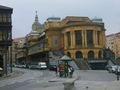
السياحة
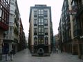
Casco Viejo, Zamudio Gate.
La Ribera market .
The Teatro Arriaga opera house.


المتاحف

الكنائس
- Santiago Cathedral
- Saint Anton church
- Basilica of Begoña
- Saint Nicholas of Bari church
- Santos Juanes church
- Saint Vincent church


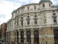
المباني المدنية
- Arriaga Theater
- Bizkaia Delegation Palace
- City Hall
- Chavarri Palace (Moyúa square)
- Plaza Nueva
- Ribera Market
- San Mamés Stadium
- University of Deusto
المتنزهات

التعليم
[[File:Universidad de Deusto.jpg|thumb|The main building of the University of Deusto.]
الجامعات
النقل
|
|


الثقافة
المهرجانات
الرياضة
مدن شقيقة
|
|
|
انظر أيضا
المصادر
- ^ بلباو, الموسوعة العربية
- ^ "Valores Climatológicos Normales. Bilbao/Aeropuerto". AEMET. Retrieved 20 أكتوبر 2010.
- ^ "Monthly Weather Averages for Bilbao Airport". Aena. Retrieved 20 أكتوبر 2010.
- ^ "Territorio y climatología" (PDF). Ayuntamiento de Bilbao. Retrieved 10 أكتوبر 2010.
- ^ "Tbilisi Municipal Portal - Sister Cities". © 2009 - Tbilisi City Hall. Retrieved 16 يونيو 2009.
قائمة المراجع
- Beascoechea Madina, José María (1999). Bilbao en el espejo. La Bilbao más antigua 1300/1700. Bilbao. p. 194. ISBN 84-605-7844-5.
{{cite book}}: CS1 maint: location missing publisher (link) - Gómez Piñeiro, Francisco Javier (1979). Geografía de Euskal Herria: Vizcaya. San Sebastián. p. 291. ISBN 84-7407-068-6.
{{cite book}}: Unknown parameter|coauthors=ignored (|author=suggested) (help); Unknown parameter|editorial=ignored (help)CS1 maint: location missing publisher (link) - Montero, Manuel (2000). Construcción histórica de la villa de Bilbao. San Sebastián. p. 142. ISBN 84-7148-384-X.
{{cite book}}: Unknown parameter|editorial=ignored (help)CS1 maint: location missing publisher (link) - Olaizola Elordi, Juanjo (2002). Bilboko tranbiak-Los tranvías de Bilbao (PDF). Bilbao. p. 177. ISBN 84-920629-8-3. Retrieved 26 أكتوبر 2008.
{{cite book}}: Unknown parameter|editorial=ignored (help)CS1 maint: location missing publisher (link)[dead link] - Pérez Pérez, José Antonio (2001). Bilbao y sus barrios: una mirada desde la historia. Bilbao. ISBN 978-84-88714-94-7.
{{cite book}}: Unknown parameter|editorial=ignored (help)CS1 maint: location missing publisher (link) - Quiroga, Ramón (2001). Bilbao: 700 años de historia. Abanto y Ciérvana. p. 115. ISBN 84-9314943-8.
{{cite book}}: Unknown parameter|coauthors=ignored (|author=suggested) (help); Unknown parameter|editorial=ignored (help)CS1 maint: location missing publisher (link) - Sánchez-Beaskoetxea (2006). La vuelta a Bilbao a través de sus montes y de su historia. Bilbao. p. 94. ISBN 978-84-88714-93-0.
{{cite book}}: Unknown parameter|editorial=ignored (help); Unknown parameter|name=ignored (help)CS1 maint: location missing publisher (link) - Tusell Gómez, Javier (2004). Bilbao a través de su Historia. Bilbao. p. 212. ISBN 84-95163-91-8.
{{cite book}}: Unknown parameter|editorial=ignored (help)CS1 maint: location missing publisher (link) - V.A. (1998). La Ría, una razón de ser. Bilbao. p. 147.
{{cite book}}: Unknown parameter|editorial=ignored (help); Unknown parameter|month=ignored (help)CS1 maint: location missing publisher (link) - V.A. (2000). El karst de Pagasarri. ISBN 84-7752-319-3.
{{cite book}}: Unknown parameter|editorial=ignored (help)
وصلات خارجية
- Bilbao's official web page
- Bilbao's Chamber of Commerce official tourism website on the city and surrounding areas
- بلباو travel guide from Wikitravel
- Bilbao in Google Maps
- BILBAO in the Bernardo Estornés Lasa - Auñamendi Encyclopedia (Euskomedia Fundazioa) (بالإسپانية)
- Bilbao Photogallery in RetratoIberico.com
- Skyscraperpage.com Bilbao's skyscraper diagram
- Bilbao Exhibition Centre
- Bilbao Weather Forecast
- The European Agency for Safety and Health at Work (EU-OSHA) is based in Bilbao (see also European Agency for Safety and Health at Work)
Coordinates: 43°15′51″N 2°55′25.50″W / 43.26417°N 2.9237500°W{{#coordinates:}}: لا يمكن أن يكون هناك أكثر من وسم أساسي واحد لكل صفحة
Categoryلبلديات في بسكاي [[Category:: أماكن أنشئت في 1300s]]