تايپينگ (جزيرة)


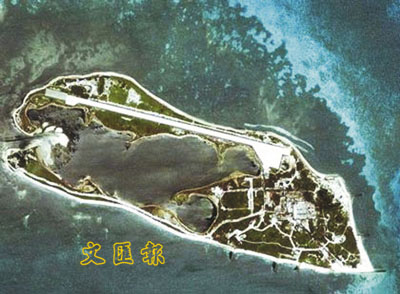
جزيرة تايپينگ Taiping Island، وتُعرف أيضاً بإسم جزيرة إيتو آبا Itu Aba وبعديد من الأسماء الأخرى، هي أكبر الجزر المتواجدة طبيعياً [1] جزر سپراتلي في بحر الصين الجنوبي.[2][3][4][5] الجزيرة بيضاوية الشكل بطول 1.4 كم وبعرض 0.4 كم، بمساحة 46 هكتار (110 acre). وهي جزء من Tizard Bank (Zheng He Reefs; 鄭和群礁). مدرج مطار جزيرة تايپينگ هو أبرز معالم الجزيرة، إذ يجري بكامل طول الجزيرة.
الجزيرة تديرها جمهورية الصين (ROC)، كجزء من Cijin, كاوشونگ. وهي أقصى النقاط جنوباً في أراضي تايوان. كما يطالب بها جمهورية الصين الشعبية والفلپين وڤيتنام.
شعاب ژونگژو المجاور هو أيضاً تحت سيطرة تايوان.
الأسماء
جزيرة تايپينگ (الصينية: 太平島; پنين: Tàipíng Dǎo; lit. 'جزيرة السلام') سُميت تكريما لسفينة حربية تابعة للبحرية الصينية الوطنية كانت قد أبحرت إلى الجزيرة في 1946,[6] حين سلّمت اليابان جزر بحر الصين الجنوبي للصين بعد الحرب العالمية الثانية.[7] الاسم "جزيرة تايپينگ" تستخدمه كل من تايپـِيْ[8] و بـِيْجينگ.[9] كما سُمِّيت الجزيرة هوانگشانما جياو (黃山馬礁) و هوانگشانما ژي (黃山馬峙) من قِبل الصيادين الصينيين.
التاريخ
أكدت الصين على سيادتها، بالمفهوم الحديث، على الجزيرة ببحر الصين الجنوبي حين اعترضت رسمياً على جهود فرنسا لضم إيتو آبا وجزر وصخور أخرى إلى الهند الصينية الفرنسية أثناء الحرب صينية الفرنسية 1884-1885. معاهدة الحدود لعام 1887 الموقعة بين فرنسا والصين وضعت جزر سپراتلي وپاراسل تحت الحكم الصيني.[citation needed] الخرائط الصينية منذ ذلك الحين، كلها، أظهر ملكية الصين لها، في البدء كخط متصل ثم كخط متقطع.
في البداية، اعترفت فرنسا بسيادة الصين على جزر سپراتلي وپاراسل، مقابل اعتراف الصين بڤيتنام كأرض فرنسية.[citation needed] In 1932, a year after the Japanese formally invaded northeast China (Manchuria), France formally claimed both جزر سپراتلي وپاراسل. China and Japan both protested. وفي 1933، استولت فرنسا على جزر سپراتلي وپاراسل، معلنةً ضمهم، رسمياً إلى الهند الصينية الفرنسية، وبنت محطتي أرصاد جوية عليهما، إلا أنها لم تزعج الصيادين الصينيين المتواجدين فيهم. وفي 1938 استولت اليابان على الجزر من فرنسا، ووضعت حامية عليهما وبنت قاعدة غواصات في جزيرة إيتو آبا (الآن تايپينگ / 太平). وفي 1941، جعلت الامبراطورية اليابانية جزر سپراتلي وپاراسل جزءاً من تايوان، ثم تحت حكمها.
وفي 1945، حسب إعلاني القاهرة وپوتسدام وبمساعدة أمريكية، قبلت القوات المسلحة لحكومة جمهورية الصين في نانجينگ استسلام الحاميات اليابانية في تايوان، بما فيهم جزر سپراتلي وپاراسل. ثم أعلنت نانجينگ الأرخبيلين جزءاً من مقاطعة گوانگدونگ. طالبت فرنسا بالجزيرة كجزء من الهند الصينية الفرنسية في 1887. They occupied it in 1932 to assert control, and in reaction to a 1932 protest by the Chinese of their sovereignty of the Paracels.[10] During الحرب العالمية الثانية, it was invaded by Japan and converted to a submarine base.[11] It was administratively attached to the municipality of Takao (Kaohsiung) in the Japanese colony of Taiwan.

On 6 November 1946, the ROC government sent four warships to the South China Sea to secure islands within the region, commanded by Lin Zun and Yao Ruyu (姚汝鈺): ROCS Chung-Yeh (中業號), ROCS Yung-hsing (永興號), ROCS Tai-ping (太平號) and ROCS Chung-chien (中建號). The warships departed from Guangzhou and headed towards the Spratly and Paracel island groups. On 12 December the two ships led by Lin Zun, ROCS Tai-ping and ROCS Chung-Yeh, arrived at Taiping Island. In commemoration of the island being secured, the island was chosen to be named after the ROCS Tai-ping warship, and thus a stone stele reading "Taiping island" was erected on a breakwater tip southwest of the island.[6] The other three ships likewise had their names used: Woody Island (in the Paracels) was named Yongxing (Yung-hsing) Island (presently PRC-occupied), Triton Island (Paracels) was named Zhongjian (Chung-chien) Island (presently PRC-occupied), and Thitu Island (Spratlys) was named Zhongye (Chung-Yeh) Island (presently Philippines-occupied).
After being secured by Nationalist China, the island was placed under the administration of China's Guangdong Province. When the Chinese Communists gained control of mainland China, the defeated Nationalists retreated to Taiwan, but retained control of the Taiping garrison.[12] Japan officially renounced its control and transferred the island to the trusteeship of the Allied Powers within the San Francisco Peace Treaty on September 8, 1951.[13] A different interpretation is that Japan officially renounced its sovereignty and transferred the island to the Republic of China under the provisions of the Taipei Peace Treaty.[when?][14]
In 1952, a Philippine civilian began to mine sulfur from Taiping Island and that same year, a note attached to the Treaty of Taipei provided the Nationalist Chinese arguments for sovereignty over the island. The Nationalists established a permanent presence on the island in July 1956.[15]
From 2000, a detachment of the ROC Coast Guard Administration was stationed on the island, replacing the Marine Corps detachment. The Taiping Island Airport was completed in December 2007,[16] and a C-130 Hercules transporter airplane first landed on the island on 21 January 2008.
On 2 February 2008, ROC president Chen Shui-bian personally visited the island accompanied by a significant naval force including two fleets with Kidd class destroyer flagships and two submarines.[17] On 19 April 2011, it was announced that the Marine Corps would once again be stationed on the island.[18]
In February 2012, the ROC began construction of an antenna tower and associated facilities with the purpose of providing navigation assistance for aircraft landing. The tower had a planned height of approximately 7 to 8 metres, and was scheduled to be completed in April 2012, and fully functional after proper testing in September 2012.[19] In July 2012, ROC authorities revealed a project which intended to extend the runway by 500 metres, which would allow the island to accommodate various kinds of military aircraft.[20]
In late August 2013, the ROC government announced that it would spend US$112 million on upgrading the island's airstrip, and constructing a dock capable of allowing its 3,000-ton Coast Guard cutters to dock, due to be completed by 2016.[21]
مدن شقيقة
The following are sister cities with Taiping Island:
 لنكون، نبراسكا, U.S[22]
انظر أيضاً
- Taiping Island Airport
- Zhongzhou Reef
- List of maritime features in the Spratly Islands
- Dongsha Islands (Pratas Islands)
- South China Sea Islands
- List of islands of the Republic of China
الهامش
- ^ لاحظ أنه في 2014 بدأت جمهورية الصين الشعبية في مشاريع خلق عدد من الجزر الاصطناعية في جزر سپراتلي. ويبدو أن أكبر تلك الجزر الاصطناعية، في Fiery Cross Reef تبلغ مساحتها ما لا يقل عن 60 هكتار، وحسب بعض المصادر غير الموثـَّقة، ربما تبلغ 150 هكتار. Kristine Kwok and Minnie Chan (2014-06-08). "China plans artificial island in disputed Spratlys chain in South China Sea". South China Morning Post. Retrieved 2014-09-28.
- ^ C.Michael Hogan (2011) South China Sea Topic ed. P.Saundry. Ed.-in-chief C.J.Cleveland. Encyclopedia of Earth. National Council for Science and the Environment. Washington DC
- ^ "Taiping Island". Spratly islands. Marine National Park Headquarters (Republic of China). Retrieved 21 March 2014.
- ^ "Itu Aba - Inquirer Global Nation". Philippine Daily Inquirer. Retrieved 19 Aug 2014.
- ^ Michael Gold. "Taiwan Considers Permanent Armed Ships For Disputed South China Sea Island". Reuters. Retrieved 16 Oct 2014.
- ^ أ ب 吕一燃 (Lu Yiran), 2007. 中国近代边界史 (A modern history of China's borders), Vol. 2. 四川人民出版社 (Sichuan People's Publishing), pp.1092-1093. ISBN 7220073313
- ^ "Itu Aba Island [Taiping Island], Spratly Islands". GlobalSecurity.org. 9 July 2011.
- ^ Soong, Grace, "Taiping Island camp shows sovereignty: Ma", The China Post, July 19, 2011.
- ^ Zhu Xianlong, "Commentary: Taiwan Independence No Easy Thing", People's Daily Online, August 14, 2002.
- ^ Ben Cahoon. "Paracel and Spratly Islands - timeline". www.worldstatesmen.org.
- ^ Sopheada Phy, (2010). The Management of the Spratly Islands Conflict: Success Or Failure? GRIN Verlag, p.2. ISBN 3640602722
- ^ Spratly Islands. Microsoft Encarta Online Encyclopedia 2008. Archived from the original on 2009-10-31.
{{cite encyclopedia}}: Unknown parameter|deadurl=ignored (|url-status=suggested) (help) - ^ "Cable: 1973MANILA00858_b - Spratley Islands". www.wikileaks.org. 23 January 1973.
- ^ "Taipei Peace Treaty". Retrieved 26 October 2014.
- ^ Severino, Rodolfo, Where in the World Is the Philippines?: Debating Its National Territory, 2011, p. 79, ISBN 978-981431170-0.
- ^ "MND admits strategic value of Spratly airstrip." Taipei Times. 6 January 2006. p. 2 (MND is the ROC Ministry of National Defense)
- ^ Shih Hsiu-chuan, Hsu Shao-hsuan, and Jimmy Chuang. "President visits disputed islands." Taipei Times. 3 February 2008. p. 1.
- ^ Cindy Sui, 19 April 2011, Taiwan to boost forces in disputed Spratly Islands, BBC News
- ^ 6 February 2012, 太平島 將建助導航塔, Liberty Times
- ^ July 15, 2012, Taiwan mulls extending runway in Spratlys: report, The West Australian Archive copy at the Internet Archive
- ^ 2013-09-02, Taiwan Plans New Infrastructure for Disputed South China Sea Claim, Voice of America
- ^ "InterLinc - City of Lincoln - Mayor's Dept Sister Cities". City of Lincoln, Nebraska. Archived from the original on 19 December 2013. Retrieved 24 December 2013.
وصلات خارجية
- Satellite image of Taiping Island by Google Maps (Contains no sign of the 1150m runway.)
- Putative States in the Spratly Archipelago
- "Ecological Resources". Discovering the South China Sea. vm.nthu.edu.tw.
- "Itu Aba Island". Discovering the South China Sea. vm.nthu.edu.tw.
- paper.wenweipo.com - (Perhaps) Contains an undoctored 2008 satellite photo of the island showing the runway and (one) adjacent "standing area".
- CS1 errors: unsupported parameter
- Pages using gadget WikiMiniAtlas
- مقالات تحتوي نصوصاً باللغة الصينية
- Articles with unsourced statements from January 2016
- Vague or ambiguous time from October 2014
- جزر سپراتلي
- جزر متنازع عليها
- جزر تايوان
- تضاريس كاوشونگ
- Territorial disputes of the Philippines
- Territorial disputes of Vietnam
- نزاعات حدودية في الصين
- نزاعات حدودية في جمهورية الصين
- Tizard Bank