هضبة الدكن
| Deccan | |
|---|---|
| Deccan Plateau, Deccan Peninsula | |
 | |
| أعلى نقطة | |
| الارتفاع | 600 متر[convert: unknown unit] |
| الإحداثيات | 15°N 77°E / 15°N 77°E |
| التسمية | |
هضبة الدكن Deccan Plateau (مراثي: डेक्कन) هي أرض مسطحة شاسعة وفيها مختلف التضاريس وتشكل معظم جنوب الهند وتقع بين ثلاث سلاسل للجبال وتنتشر في 8 ولايات. مرتفعاتها تشكل مثلث داخلي يقبع داخل مثلث مشابه رأسه لأسفل وهو شبه القارة الهندية.[1] وهي من الناحية الفنية هضبة شاسعة وفيها تنوع واسع للحياة البرية, وتضم معظم وسط وجنوب الهند.[2] ويحدها من الغرب الغات الغربية ومن الشرق الغات الشرقية وتبرز كل منها من السهول الساحلية ليتلاقيا تقريباً عند الطرف الجنوبي للهند. هذان التشكيلان يصنعا الطرف الجنوبي المدبب لمثلث شبه القارة الهندية والذي يضم الهضبة وسلسلة جبال ساتپورا التي تجري تقريباً غرب-جنوب-غرب إلى شرق-شمال-شرق و سلسلة جبال ڤينديا التي تشكل الجانب الثالث للمثلث المقلوب (على شكل ناب كلب). هذه السلاسل الجبلية تفصل الأرض المنبسطة عن سهول أنهار شمال الهند شديدة الازدحام.

وتشكل مساحات كبيرة من ولايات مهرشترا، كرناتكا وأجزاء من أندرا پرادش وجنوب سلسلة جبال ساتپورا وارتفاعها يتراوح من 100 متر في الشمال إلى 1000 متر في الجنوب.
كلمة دكن Deccan تأتي من الپركريتية دكخن dakkhin وهي بدورها مشتقة من اللغة السنسكريتية दक्षिण "دكشينا"، ومعناها الجنوب، وهذه التسمية مستمدة من موقعها الجنوبي في شبه القارة الهندية.[3]
أصل الاسم
The word Deccan is an anglicized version of the Prakrit word dakkhaṇa,[4][5][6] which is used in other languages of the Deccan including Kannada, Telugu, Marathi, and Dakhni. It has etymological roots in the Sanskrit dakṣiṇa which evolved into the later Prakrit one.
جغرافيا


تشغل الدكن الجزء الجنوبي من شبه الجزيرة الهندية، ممتدة بين نهر ناربادا (نارمادا) في الشمال ونهر كريشنا (كيستنا) في الجنوب، وهذا يعني أنها لا تشغل كامل جنوب الهند، وإنما الأرض المرتفعة الباردة نسبياً فقط.[7]
وكثيراً ما يضم إلى هضبة الدكن هضبة ميسور، امتدادها الجنوبي، لتصل بذلك جنوباً إلى نهر غوفري. وتحاط الدكن بجبال الغات الغربية من الغرب، والغات الشرقية من الشرق وتلال نيلجيري من الجنوب، ومن الشمال سلسلة جبال ساتپورا التي تشرف على نهر ناربادا من الجنوب. وتتوزع أراضي الدكن على الولايات الهندية الآتية: ماهراشترا، ومادهيا براديش، واندهرابراديش، وميسور، والأجزاء الغربية من ولاية أوريسا. وظهيرها الجغرافي الشمالي هو سهل الغانج، بينما يشكل سهل ملبار والمحيط الهندي ظهيرها الغربي، أما سهل كرومندل وجبال الغات الشرقية وخليج البنغال فتشكل ظهيرها الشرقي، وولاية تاميل نادو ظهيرها الجنوبي، وتشغل الدكن مساحة تقرب من 40% من مساحة الهند، أي نحو 1.3 مليون كم2.
الدكن هضبة بركانية مرتفعة، يبلغ متوسط ارتفاعها نحو 750م، وانحدارها عموماً من الغرب باتجاه الشرق متدرجاً من 1300م تقريباً في الغرب إلى 600م تقريباً في الشرق، كما أنها أكثر ارتفاعاً في الجنوب من الشمال، وهي ذات سطح غير منبسط، لتقطعها بالأودية النهرية العديدة، ولبروز العديد من التلال فيما بين الأحواض النهرية.
المناخ
يسود هضبة الدكن مناخٌ موسميٌ، إذ يهطل نحو 80% من الأمطار السنوية في نصف السنة الصيفي (أيار - تشرين الأول) و تسود في تلك المدة الرياح الجنوبية الغربية الموسمية الرطبة التي تفرغ جزءاً من حمولتها فوق جبال الغات الغربية، وتراوح كمية الأمطار السنوية بين 400-1000مم، وقد تتعدى 1000مم في الأجزاء الشمالية الشرقية التي تتلقى ما لا يقل عن 25% من أمطارها في فصل الشتاء، من الموسميات الشمالية الشرقية العابرة خليج البنغال، والمتوسط الحراري يراوح بين 18-24 ْ في فصل الشتاء، وبين 30-33 ْ في فصل الصيف.
وتسود في أجزاء الهضبة الشمالية الشرقية والغربية الغابات الموسمية (أشجار الساج والسال.... وغيرها) كما تنتشر في أواسطها ذات الأمطار التي تراوح بين 500-750مم، الغابات الشوكية المختلطة مع الحشائش.
وتنصرف مياه الهضبة عبر مجموعة من الأنهار، ينبع معظمها من المنحدرات الشرقية لجبال الغات الغربية وتصب في خليج البنغال أنهار غوادفري، كريشنا، بينر، غوفري، والنهران الشماليان (نهر تاربادا، ونهر تابيتي) اللذان ينحدران غربا،ً ليصبا في خليج كامبهات ببحر العرب.
السكان
يقطن هضبة الدكن نحو ربع سكان الهند، أي نحو 250 مليون نسمة، بمتوسط كثافة 170 نسمة/كم2. ويزداد السكان كثافة في مناطق الوديان النهرية الخصبة والمروية، ويقلون نسبياً في المناطق شبه الجافة الواقعة بين الوديان النهرية، ويتوزع سكانها على مجموعتين بشريتين هما: الدرافيديون في نصفها الجنوبي، والقوقازيون في نصفها الشمالي. ويتكلم سكانها عدة لغات منها: الماراثية والدرافيدية بتنوعاتها والهندية ويدين الغالبية العظمى من سكانها بالهندوسية، وقليل منهم بالإسلام.

ومن أهم مدن الهضبة: حيدر أباد، ناگپور، شولايور، أمرفاتي، بنگالور، ميسور، سالم.
ولوفرة الأنهار في الهضبة، انتشرت على جوانبها وقريباً منها المزروعات المروية، وخاصة القطن والذرة. وقد أسهمت وفرة الأمطار في أجزائها الغربية والشمالية الشرقية في نجاح العديد من محاصيل الزراعات البعلية، كالقمح وغيره، ومما ساعد على ذلك أيضاً التربة البركانية الخصبة، وخاصة في الشمال، ومن أهم المحاصيل الزراعية: القطن في وسطها وشمالها الغربي، والذرة، والحبوب الزيتية. وتنتشر زراعة الشاي والبن في جزئها الجنوبي، وتشتهر الهضبة بتربية الأغنام بجانب الأبقار والماعز.
ويستخرج من أراضيها بعض المعادن، ومن أهمها المنگنيز، إضافة إلى كميات لا بأس بها من الحديد والنحاس والكروميت. وفيها العديد من الصناعات، كما في صناعة الحديد والصلب في مدينتي بهادرفاتي وسالم، والصناعات الميكانيكية في بنغالور، وكذلك الصناعات الكيميائية والإسمنت والمنسوجات في مدنها الكبرى.
المناخ
The climate of the region varies from semi-arid in the north to tropical in most of the region with distinct wet and dry seasons. Some patches of desert exist in the deep centre. Rayalaseema and Vidarbha are the driest regions. Rain falls during the monsoon season from about June to October. March to June can be very dry and hot, with temperatures regularly exceeding 35 °C.
The plateau's climate is drier than that on the coasts and is arid in places. Although sometimes used to mean all of India south of the Narmada River, the word Deccan relates more specifically to that area of rich volcanic soils and lava-covered plateaus in the northern part of the peninsula between the Narmada and Krishna rivers.
مصائد الدكن
The northwestern part of the Deccan Plateau, a Precambrian shield, is partially covered by the Deccan Traps ("Deccan steps"), a large igneous province made up of a series of flood basalt lava flows. This rocky material covers the whole of Maharashtra, thereby making it one of the largest Volcanic Provinces in the world. It consists of more than 2،000 متر (7،000 ft) of basalt lava flows and covers an area of nearly 500،000 km2 (190،000 sq mi) in west-central India. Estimates of the original area covered by the lava flows are as high as 1،500،000 km2 (580،000 sq mi). The volume of basalt is estimated to be 511,000 km3. The deep, dark, silty soil found here is suitable for cotton cultivation.
Geology
Typically, the Deccan Plateau is made up of basalt, an extrusive igneous rock, extending up to Bhor Ghat near Karjat. Also, in certain sections of the region we can find granite, which is an intrusive igneous rock.
The difference between these two rock types is that basalt rock forms on eruption of lava, that is, on the surface (either out of a volcano, or through massive fissures—as in the Deccan basalts—in the ground), while granite forms deep within the Earth. Granite is a felsic rock, meaning it is rich in potassium feldspar and quartz. This composition is continental in origin (meaning it is the primary composition of the continental crust). Since it cooled relatively slowly, it has large visible crystals.
Basalt, on the other hand, is mafic in composition—meaning it is rich in pyroxene and, in some cases, olivine, both of which are Mg-Fe rich minerals. Basalt is similar in composition to mantle rocks, indicating that it came from the mantle and did not mix with continental rocks. Basalt forms in areas that are spreading, whereas granite forms mostly in areas that are colliding. Since both rocks are found in the Deccan Plateau, it indicates two different environments of formation.
The volcanic basalt beds of the Deccan were laid down in the massive Deccan Traps eruption, which occurred towards the end of the Cretaceous period between 67 and 66 million years ago. Some paleontologists speculate that this eruption may have been one of the causes of the Cretaceous-Paleogene extinction event. Layer after layer was formed by the volcanic activity that lasted many thousands of years, and when the volcanoes became extinct, they left a region of highlands with typically vast stretches of flat areas on top like a table. The volcanic hotspot that produced the Deccan traps is hypothesized to lie under the present-day island of Réunion in the Indian Ocean.[8]
The Deccan is rich in minerals. Primary mineral ores found in this region are mica and iron ore in the Chhota Nagpur region, and diamonds, gold and other metals in the Kollur region and Kolar Gold Fields.
الوحيش
The large areas of remaining forest on the plateau are still home to a variety of grazing animals from the four-horned antelope (Tetracerus quadricornis),[9] chinkara (Gazella bennettii),[9] and blackbuck (Antilope cervicapra) to the gaur (Bos gaurus; /ɡaʊər/) and wild water buffalo (Bubalus arnee).
الناس
Northern Deccan is inhabited by Indo-Aryan peoples. Major groups include Marathi people and Deccani people. The Marathi language is spoken in the Maharashtra State while the Deccani language, which is a variety of Hindustani is spoken in northern Telangana, northeastern Karnataka and southeastern Maharashtra with the city of Hyderabad being a major stronghold of the language.
Southern Deccan is inhabited by Dravidian peoples who speak include Telugu and Kannada, Tamil the predominant languages of Telangana, Karnataka & Tamilnadu respectively occupy those states' portions of the plateau.
تاريخ

- انظر تاريخ الهند، امبراطورية المغول، سلطنات الدكن، أسرة چالوكيا، أسرة چولا، امبراطورية هويسالا، أسرة كاكتيا، راشتراكوتا، أسرة ياداڤا، امبراطورية ڤيجاياناگارا، امبراطورية مراثا
التاريخ القديم للمنطقة يكاد أن يكون مجهولاً، على الرغم مما عثر فيها من بقايا من العصور الحجرية وعصر الحديد والبرونز، إلا أنها بقيت لفترة طويلة منطقة نزاع بين الدرافيديين في الجنوب والآريين في الشمال. ومع أن الدكن كانت لفترات تحت حكم واحد، إلا أنها كانت مقسمة عادة إلى ولايات صغيرة، وفي أحد العصور كانت محتلة من قبل ملوك أندهرا، وفي القرن الثالث عشر الميلادي دخلها المسلمون، وأصبحت عبارة عن سلطنات وممالك. وبقيت مدينة حيدر أباد مركزاً للهضبة حتى عام 1948، وهي أكبر مدن الدكن بنسبة سكانها المسلمين.
The Deccan produced some of the most significant dynasties in Indian history, such as the Vijayanagara Empire, the Rashtrakuta dynasty, the Chola dynasty, the Thagadur dynasty, Adhiyamans Pallavas, the Tondaiman, Satavahana dynasty, Vakataka dynasty, Kadamba dynasty, Chalukya dynasty, Yadava dynasty, Kakatiya Dynasty, Western Chalukya Empire, Maratha Empire, and Mysore Kingdom.
Of the early history, the main facts established are the growth of the Maurya Empire (300 BCE) and after that the Deccan was ruled by the Satavahana dynasty, which protected the Deccan against the Scythian invaders, the Western Satraps.[10] Prominent dynasties of this time include the Cholas (3rd century BCE to 12th century CE), Chalukyas (6th to 12th centuries), Rashtrakutas (753–982), Yadavas (9th to 14th centuries), Hoysalas (10th to 14th centuries), Kakatiya (1083 to 1323 CE), and Vijayanagara Empire (1336–1646).

Ahir Kings once ruled over the Deccan. A cave inscription at Nasik refers to the reign of an Abhira prince named Ishwarsena, son of Shivadatta.[11] After the collapse of the Satavahana dynasty, the Deccan was ruled by the Vakataka dynasty from the third century to fifth century.[citation needed]
From the sixth to eighth century, the Deccan was ruled by the Chalukya dynasty which produced great rulers such as Pulakesi II, who defeated the north India Emperor Harsha, and Vikramaditya II, whose general defeated the Arab invaders in the eighth century.
From the eighth to tenth century, the Rashtrakuta dynasty ruled this region. It led successful military campaigns into northern India and was described by Arab scholars as one of the four great empires of the world.[12]
In the tenth century, the Western Chalukya Empire, which produced scholars such as the social reformer Basavanna, Vijñāneśvara, the mathematician Bhāskara II, and Someshwara III, who wrote the text Manasollasa, was established.
From the early 11th century to the 12th century, the Deccan Plateau was dominated by the Western Chalukya Empire and the Chola dynasty.[13] Several battles were fought between the Western Chalukya Empire and the Chola dynasty in the Deccan Plateau during the reigns of Raja Raja Chola I, Rajendra Chola I, Jayasimha II, Someshvara I and Vikramaditya VI, and Kulottunga I.[14]
In 1294, Alauddin Khalji, emperor of Delhi, invaded the Deccan, stormed Devagiri, and reduced the Yadava rajas of Maharashtra to the position of tributary princes (see Daulatabad), then proceeded southward to conquer the Orugallu, Carnatic. In 1307, a fresh series of incursions led by Malik Kafur began in response to unpaid tributes, resulting in the final ruin of the Yadava clan; and in 1338, the conquest of the Deccan was completed by Sultan Muhammad bin Tughluq.
The imperial hegemony was brief, as soon the earlier kingdoms reverted to their former masters. These defections by the states were soon followed by a general revolt of the foreign governors, resulting in the establishment in 1347 of the independent Bahmani dynasty.[15] The power of the Delhi sultanate evaporated south of the Narmada River. The southern Deccan came under the rule of the famous Vijayanagara Empire, which reached its zenith during the reign of Emperor Krishnadevaraya.[16]
Vijayanagara Empire jostled for control over the key regions in the Deccan as territories were regularly fought out for against the Bahmani Sultanate. Krishnadevaraya of the Vijayanagara Empire defeated the last remnant of Bahmani Sultanate power after which the Bahmani Sultanate collapsed.[17] When the Bahmani empire dissolved in 1518, its dominions were distributed into the five Muslim states of Golkonda, Bijapur, Ahmednagar, Bidar and Berar, giving rise to the Deccan sultanates.[15]

South of these, the Hindu state of Carnatic or Vijayanagar still survived; but this, too, was defeated, at the Battle of Talikota (1565) by a league of the Muslim powers. Berar had already been annexed by Ahmednagar in 1572, and Bidar was absorbed by Bijapur in 1619. Mughal interest in the Deccan also rose at this time. Partially incorporated into the Empire in 1598, Ahmadnagar was fully annexed in 1636; Bijapur in 1686, and Golkonda in 1687.
In 1645, Shivaji laid the foundation of the Maratha Empire. The Marathas under Shivaji directly challenged the Bijapur Sultanate and ultimately the mighty Mughal empire. Once the Bijapur Sultanate stopped being a threat to the Maratha Empire, Marathas became much more aggressive and began to frequently raid Mughal territory. These raids, however, angered the Mughal Emperor Aurangzeb, and by 1680, he moved his capital from Delhi to Aurangabad in Deccan to conquer Maratha-held territories. After Shivaji died, his son Sambhaji defended the Maratha empire from the Mughal onslaught but was captured by the Mughals and executed. By 1698, the last Maratha stronghold at Jinji fell and Mughals then controlled all Maratha held territories.
In 1707, Emperor Aurangzeb died at the age of 89, which allowed the Marathas to reacquire lost territories and establish authority in much of modern Maharashtra. After the death of Chhatrapati Shahu, the Peshwas became the de facto leaders of the Empire from 1749 to 1761, while Shivaji's successors continued as nominal rulers from their base in Satara. The Marathas kept the British at bay during the 18th century.
By 1760, with the defeat of the Nizam in the Deccan, Maratha power had reached its zenith. However, dissension between the Peshwa and their sardars (army commanders) saw a gradual downfall of the empire leading to its eventual annexation by the British East India Company in 1818 after the three Anglo-Maratha wars.
A few years later, Aurangzeb's viceroy in Ahmednagar, Nizam-ul-Mulk, established the seat of an independent government at Hyderabad in 1724. Mysore was ruled by Hyder Ali. During the contests for power which ensued from about the middle of the 18th century between the powers on the plateau, the French and British took opposite sides. After a brief series of victories, the interests of France declined, and a new empire in India was established by the British. Mysore formed one of their earliest conquests in the Deccan. Tanjore and the Carnatic were soon annexed to their dominions, followed by the Peshwa territories in 1818.
In British India, the plateau was largely divided between the presidencies of Bombay and Madras. The two largest native states at that time were Hyderabad and Mysore; many smaller states existed at the time, including Kolhapur, and Sawantwari.
After independence in 1947, almost all native states were incorporated into the Republic of India. The Indian Army annexed Hyderabad in Operation Polo in 1948 when it refused to join.[18] In 1956, the States Reorganisation Act reorganized states along linguistic lines, leading to the states currently found on the plateau.
-
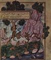 قصة بالفارسية
 -
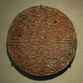 ختم طغرائي من الحجر الرملي المنحوت - القرن 16
 -
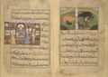 نعمة نامه نصير الدين شاهي (كتاب وصفات طبخ)


الاقتصاد
The Deccan plateau is very rich in minerals and precious stones.[19] The plateau's mineral wealth led many lowland rulers, including those of the Mauryan (4th–2nd century BCE) and Gupta (4th–6th century CE) dynasties, to fight over it.[20] Major minerals found here include coal, iron ore, asbestos, chromite, mica, and kyanite. Since March 2011, large deposits of uranium have been discovered in the Tummalapalle belt and in the Bhima basin at Gogi in Karnataka. The Tummalapalle belt uranium reserve promises to be one of the top 20 uranium reserve discoveries of the world.[21][22][23]
Low rainfall made farming difficult until the introduction of irrigation. Currently, the area under cultivation is quite low, ranging from 60% in Maharashtra to about 10% in Western Ghats.[24] Except in developed areas of certain river valleys, double-cropping is rare. Rice is the predominant crop in high-rainfall areas and sorghum in low-rainfall areas. Other crops of significance include cotton, tobacco, oilseeds, and sugar cane. Coffee, tea, coconuts, areca, black pepper, rubber, cashew nuts, cassava, and cardamom are widely grown on plantations in the Nilgiri Hills and on the western slopes of the Western Ghats. Cultivation of Jatropha has recently received more attention due to the Jatropha incentives in India.
انظر أيضاً
- جنوب الهند, التي تتضمن الدكن.
- هضبة ميسوري
- امبراطورية ڤيجاياناگارا
- امبراطورية كاكاتيا
- Bayaluseemae
المصادر
- Monier-Williams Sanskrit-English Dictionary, p. 498 (scanned image at SriPedia Initiative): Sanskrit dakṣiṇa meaning `right', `southern'.
وصلات خارجية
- صور لهضبة الدكن
- الأسرات الحاكمة في الدكن
- شبه جزيرة الدكن
- الغابات النفضية الجافة في هضبة الدكن الوسطى
- جيولوجيا هضبة الدكن
للاستزادة
- علي موسى ومحمد الحمادي، جغرافية القارات (دار الفكر، دمشق 1998).
- H.Robinson, Monsoon Asia (Macdonald and Evans, Plymouth 1976).
| الأنهار |  | ||||||||||||
|---|---|---|---|---|---|---|---|---|---|---|---|---|---|
| السدود والخزانات | |||||||||||||
| المناطق/الخصائص الجغرافية | |||||||||||||
| Riparian districts |
| ||||||||||||
| لغات/ أشخاص | |||||||||||||
| مناجم الفحم | |||||||||||||
| حقول الغاز/النفط | |||||||||||||
| الصناعات | |||||||||||||
| النقل | |||||||||||||
| موضوعات متعلقة | |||||||||||||
| أحواض أخرى | |||||||||||||
- ^ "The Deccan Peninsula". sanctuaryasia. Retrieved 2007-01-05.
- ^ "The Deccan Plateau". rainwaterharvesting.org. Retrieved 2007-01-05.
- ^ Monier-Williams Sanskrit-English Dictionary, p. 498 (scanned image at SriPedia Initiative): Sanskrit dakṣiṇa meaning 'right', 'southern'.
- ^ Henry Yule, A. C. Burnell (13 June 2013). Hobson-Jobson: The Definitive Glossary of British India. Oxford. ISBN 9780191645839.
- ^ Turner, R. L. (30 October 1966). A comparative dictionary of Indo-Aryan languages. London: Oxford University Press. Archived from the original on 5 November 2023. Retrieved 30 October 2023.
- ^ Monier-Williams Sanskrit-English Dictionary, p. 498 Archived 25 مايو 2006 at the Wayback Machine (scanned image at SriPedia Initiative): Sanskrit dakṣiṇa meaning 'southern'.
- ^ علي موسى. "الدكن". الموسوعة العربية.
- ^ "Deccan | plateau, India". Encyclopedia Britannica. 11 April 2024. Archived from the original on 29 June 2016. Retrieved 8 August 2016.
- ^ أ ب خطأ استشهاد: وسم
<ref>غير صحيح؛ لا نص تم توفيره للمراجع المسماةEB1911 - ^ History of Asia by B.V. Rao p.288
- ^ The Castes and Tribes of H.E.H. the Nizam's Dominions, Volume 1, by Syed Siraj ul Hassan-page-12
- ^ Portraits of a Nation: History of Ancient India by kamlesh kapur p.584-585
- ^ The Penguin History of Early India: From the Origins to AD 1300 by Romila Thapar: p.365-366
- ^ Ancient Indian History and Civilization by Sailendra Nath Sen: p.383-384
- ^ أ ب Marshall Cavendish Corporation (2008). India and Its Neighbors, Part 1, p. 335. Tarreytown, New York: Marshall Cavendish Corporation.
- ^ Richard M. Eaton 2005, p. 83.
- ^ Richard M. Eaton 2005, p. 88.
- ^ Benichou, Lucien D. (2000). From Autocracy to Integration: Political Developments in Hyderabad State (1938–1948), p. 232. Chennai: Orient Longman Limited.
- ^ Ottens, Berthold (1 January 2003). "Minerals of the Deccan Traps, India". HighBeam Research. Archived from the original on 11 September 2016. Retrieved 8 August 2016.
- ^ Deccan Plateau, India. Encyclopædia Britannica. Archived from the original on 29 June 2016. Retrieved 8 August 2016.
- ^ Subramanian, T. S. (20 March 2011). "Massive uranium deposits found in Andhra Pradesh". news. Chennai, India: The Hindu. Archived from the original on 24 October 2012. Retrieved 8 August 2016.
- ^ Thakur, Monami (19 July 2011). "Massive uranium deposits found in Andhra Pradesh". International Business Times. USA. Archived from the original on 18 October 2017. Retrieved 8 August 2016.
- ^ Bedi, Rahul (19 July 2011). "Largest uranium reserves found in India". The Telegraph. New Delhi, India. Archived from the original on 12 January 2022.
- ^ "Peninsular India". ita. September 1995. Archived from the original on 28 October 2016. Retrieved 8 August 2016.
- Pages using gadget WikiMiniAtlas
- Short description is different from Wikidata
- Pages using infobox mapframe without shape links in Wikidata
- Convert errors
- Coordinates on Wikidata
- Articles containing مراثي-language text
- Articles containing تلوگو-language text
- Articles containing أردو-language text
- Articles containing كنادا-language text
- No local image but image on Wikidata
- Pages using infobox mountain with unknown parameters
- Articles with hatnote templates targeting a nonexistent page
- Articles with unsourced statements from October 2021
- هضبة الدكن
- تضاريس الهند
- صفحات مع الخرائط