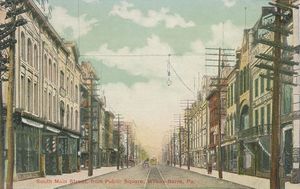
ويلكس-بار، پنسلڤانيا
ويلكس-بار
Wilkes-Barre | |
|---|---|
| الكنية: The Diamond City, W-B, Coal City | |
| الشعار: Pattern After Us | |
| خطأ لوا في وحدة:Mapframe على السطر 382: Unable to get latitude from input '<span class="geo-inline"><strong class="error">Coordinates: Missing latitude</strong><br /></span><span class="error">تم تمرير الوسائط غير الصالحة إلى الدالة '"`UNIQ--nowiki-00000006-QINU`"' function</span>'.. | |
| الإحداثيات: 41°14′40″N 75°52′41″W / 41.24444°N 75.87806°W | |
| Country | United States |
| State | Pennsylvania |
| County | Luzerne |
| Founded | 1769 |
| Incorporated | 1806: Borough |
| 1871: City | |
| السمِيْ | John Wilkes, Isaac Barré |
| الحكومة | |
| • النوع | Mayor–council |
| • الكيان | Wilkes-Barre City Council |
| • Mayor | George Brown (D) |
| المساحة | |
| • City | 7٫19 ميل² (18٫63 كم²) |
| • البر | 6٫85 ميل² (17٫74 كم²) |
| • الماء | 0٫35 ميل² (0٫90 كم²) |
| المنسوب | 525 ft (160 m) |
| التعداد | |
| • City | 44٬328 |
| • الكثافة | 6٬473٫13/sq mi (2٬499٫19/km2) |
| • Urban | 401٬884 (US: 100th) |
| • العمرانية | 562٬037 |
| منطقة التوقيت | UTC−5 (EST) |
| • الصيف (التوقيت الصيفي) | UTC−4 (EDT) |
| ZIP Codes[4] | 18701–18703, 18705, 18706, 18710, 18711, 18762, 18764–18767, 18769, 18773 |
| Area code | 570 and 272[5] |
| FIPS code | 42-85152 |
| الموقع الإلكتروني | www |
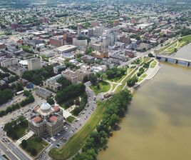
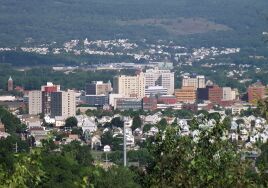
ويلكس-بار (Wilkes-Barre ؛ []wɪlksˈbɛər[] أو []ʔˈbæri[])[6] هي مدينة في كومنولث پنسلڤانيا ومقر مقاطعة Luzerne County. It is one of the principal cities in the Scranton–Wilkes-Barre–Hazleton, PA Metropolitan Statistical Area. Located at the center of the Wyoming Valley it is second only to the nearby city of Scranton. The Scranton–Wilkes-Barre–Hazleton, PA Metropolitan Statistical Area had a population of 563,631 as of the 2010 Census making it the fourth largest metro/statistical area in the state of Pennsylvania. Wilkes-Barre and the surrounding Wyoming Valley are framed by the Pocono Mountains to the east, the Endless Mountains to the west and the Lehigh Valley to the south. The Susquehanna River flows through the center of the valley and defines the northwestern border of the city.
التاريخ
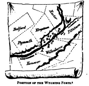
19th century (Industrial foundations)
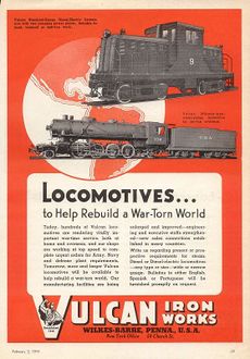
20th century
السكان
| التعداد | Pop. | ملاحظة | %± |
|---|---|---|---|
| 1800 | 835 | — | |
| 1810 | 1٬225 | 46٫7% | |
| 1820 | 755 | −38٫4% | |
| 1840 | 1٬718 | — | |
| 1850 | 2٬723 | 58٫5% | |
| 1860 | 4٬253 | 56٫2% | |
| 1870 | 10٬174 | 139٫2% | |
| 1880 | 23٬339 | 129٫4% | |
| 1890 | 37٬718 | 61٫6% | |
| 1900 | 51٬721 | 37٫1% | |
| 1910 | 67٬105 | 29٫7% | |
| 1920 | 73٬833 | 10�0% | |
| 1930 | 86٬626 | 17٫3% | |
| 1940 | 86٬236 | −0٫5% | |
| 1950 | 76٬826 | −10٫9% | |
| 1960 | 63٬068 | −17٫9% | |
| 1970 | 58٬856 | −6٫7% | |
| 1980 | 51٬551 | −12٫4% | |
| 1990 | 47٬523 | −7٫8% | |
| 2000 | 43٬123 | −9٫3% | |
| 2010 | 41٬498 | −3٫8% | |
| 2014 (تق.) | 40٬814 | [8] | −1٫6% |
| U.S. Decennial Census[9] 2013 Estimate[10] | |||
See also
Notes
References
- ^ "City Council". Retrieved February 3, 2022.
- ^ "ArcGIS REST Services Directory". United States Census Bureau. Retrieved October 12, 2022.
- ^ خطأ استشهاد: وسم
<ref>غير صحيح؛ لا نص تم توفيره للمراجع المسماةUSCensusDecennial2020CenPopScriptOnly - ^ "ZIP Code(tm) Lookup". United States Postal Service. Retrieved December 17, 2014.
- ^ "City of Wilkes Barre, PA Zip Codes". Retrieved December 17, 2014.
- ^ "About Wilkes-Barre". Wilkes-Barre official site. Retrieved June 16, 2015.
- ^ Lossing, Benson (1859). The Pictorial Field-Book of the Revolution. Harper & Brothers, Publishers. p. 353.
- ^ "Annual Estimates of the Resident Population for Incorporated Places: April 1, 2010 to July 1, 2014". Retrieved June 4, 2015.
- ^ United States Census Bureau. "Census of Population and Housing". Retrieved November 19, 2013.
- ^ "Annual Estimates of the Resident Population: April 1, 2010 to July 1, 2013". Retrieved June 29, 2014.
وصلات خارجية
- City of Wilkes-Barre official website
- Osterhout Free Library
- Wilkes-Barre Bicentennial at the Internet Archive
- "Wilkes-Barre Preservation Society". Archived from the original on January 19, 2008.
- More interesting facts about Wilkes-Barre
| [[Image:|50px]] | باك ماونتن |
| |||||
| لكاوانا، غابة ولائية |
- صفحات ذات وسوم إحداثيات غير صحيحة
- Pages using gadget WikiMiniAtlas
- Articles with hatnote templates targeting a nonexistent page
- Missing redirects
- Short description is different from Wikidata
- Pages using multiple image with auto scaled images
- Pages using infobox settlement with possible nickname list
- Coordinates on Wikidata
- Pages using US Census population needing update
- مدن پنسلڤانيا
- ويلكس-بار، پنسلڤانيا
- County seats in Pennsylvania
- Populated places on the Susquehanna River
- أماكن مأهولة تأسست في 1769
- Municipalities of the Anthracite Coal Region of Pennsylvania
- Cities in Luzerne County، پنسلڤانيا
