ورزقان
ورزقان
فارسية: ورزقان Varzaqan | |
|---|---|
مدينة | |
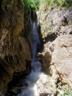
 شلال گلآخور | |
| الإحداثيات: 38°30′34″N 46°39′00″E / 38.50944°N 46.65000°E[1] | |
| البلد | إيران |
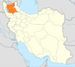
| المحافظة | أذربيجان الشرقية |
| المقاطعة | ورزقان |
| البخش | المركزي |
| المنسوب | 1٬670 m (5٬480 ft) |
| التعداد (2016)[2] | |
| • الإجمالي | 5٬348 |
| منطقة التوقيت | UTC+3:30 (IRST) |
| مفتاح الهاتف | 0414 |
| الموقع الإلكتروني | www |
وزرقان (فارسية: ورزقان؛ Varzaqan)[أ] هي مدينة في البخش المركزي في مقاطعة ورزقان[ب] محافظة أذربيجان الشرقية، إيران، تعمل كعاصمة لكل من المقاطعة والبخش.[5] كما أنها المركز الإداري لـ أزومدل جنوبي، المجلس الريفي.[6]
وفي تعداد 2006 بلغ عدد سكانها 3,549 نسمة في 930 عائلة.[7] The following census in 2011 counted 5,385 people in 1,392 households.[8] The latest census in 2016 showed a population of 5,348 people in 1,401 households.[2]
تشتهر المدينة بـمنجم نحاس سونگون، الواقع على بعد 25 كم من وسط المدينة، والذي يضم ما يُقدر بنحو 3% من احتياطيات النحاس بالعالم.[citation needed]
وفي 19 مايو 2024، سقطت مروحية تقل الرئيس الإيراني إبراهيم رئيسي ووزير الخارجية حسين عبد اللهيان بالقرب من ورزقان.
معالم تاريخية
النقش المسماري في قرية سقندل هو أشهر أثر تاريخي في المنطقة.
الزلازل
The area is subject to earthquakes, and in 2012 a number of people were killed when an earthquake doublet (magnitude 6.4 and 6.3) struck on the afternoon of 11 August.[9]
الاقتصاد
Farming is the predominant occupation in the rural areas. The area produces apple, pear, cherry, walnut and apricot fruit. Recently spruce trees have been planted as the start of a forestry industry. Cold water fish farming has been started.[10]
Varzeqan is a mining centre for base metal mining, as well as gold. The Sungun copper mine is now the largest copper mine in northwestern Iran. The deposit itself is one of the largest copper deposits in the world. There are nearby gold mines at Shrfabad, Hyzjan, Tshkhsrv, Astrgan, Andryan and Myvhrvd.[10]
انظر أيضاً
ملاحظات
- ^ كما تـُرَوْمَن Varzeqān و Warzagan؛ وسابقاً Karzigan (كَرزيگَن)، كما يُرَوْمَن Kārzigān و Karzygan[3]
- ^ Formerly Arsbaran County[4]
المراجع
- ^ OpenStreetMap contributors (26 February 2024). "Varzaqan, Varzaqan County" (Map). OpenStreetMap. Retrieved 26 February 2024.
- ^ أ ب "Census of the Islamic Republic of Iran, 1395 (2016)". AMAR (in الفارسية). The Statistical Center of Iran. p. 03. Archived from the original (Excel) on 13 November 2020. Retrieved 19 December 2022.
- ^ ورزقان can be found at GEOnet Names Server, at this link, by opening the Advanced Search box, entering "-3088233" in the "Unique Feature Id" form, and clicking on "Search Database".
- ^ "Approval of changing the name of the new county of Arsbaran to Varzaqan by the ministers who are members of the Political Commission". Research Center of the System of Laws of the Islamic Council of the Farabi Library (in الفارسية). Ministry of Interior, Political-Defense Commission of the Government Board. Archived from the original on 9 June 2013. Retrieved 6 December 2023.
- ^ Aref, Mohammad Reza. "Approval letter regarding the abstraction of Varzaqan and Kharvana Districts from Ahar County and its transformation into Arsbaran County". Islamic Parliament Research Center (in الفارسية). Ministry of Interior, Council of Ministers. Archived from the original on 14 June 2013. Retrieved 6 December 2023.
- ^ Mousavi, Mirhossein (18 May 1366). "Creation and formation of 30 rural districts including villages, farms and places in Ahar County under East Azerbaijan province". Islamic Council Research Center (in الفارسية). Ministry of Interior, Board of Ministers. Archived from the original on 26 October 2010. Retrieved 29 November 2023.
- ^ "Census of the Islamic Republic of Iran, 1385 (2006)". AMAR (in الفارسية). The Statistical Center of Iran. p. 03. Archived from the original (Excel) on 20 September 2011. Retrieved 25 September 2022.
- ^ "Census of the Islamic Republic of Iran, 1390 (2011)". Syracuse University (in الفارسية). The Statistical Center of Iran. p. 03. Archived from the original (Excel) on 16 January 2023. Retrieved 19 December 2022.
- ^ "Iran earthquake relief efforts begin after 250 killed". BBC News. 12 August 2012.
- ^ أ ب Arzyl, Ahmed Hassan Nejad ( احمد حسن نژاد ارزیل) (2010). "تاریخچه شهرستان ورزقان (History of Varzeqan)". Archived from the original on 2012-08-21. Retrieved 2012-08-11.
- Pages using gadget WikiMiniAtlas
- CS1 الفارسية-language sources (fa)
- Short description is different from Wikidata
- Articles with hatnote templates targeting a nonexistent page
- Articles containing فارسية-language text
- Coordinates on Wikidata
- Articles with unsourced statements from February 2024
- مدن محافظة أذربيجان الشرقية
- أماكن مأهولة في مقاطعة ورزقان


