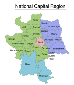
منطقة العاصمة الوطنية (الهند)
National Capital Region | |
|---|---|
Region | |
 Map of National Capital Region | |
| الإحداثيات: 28°39′38″N 77°06′32″E / 28.66056°N 77.10889°E | |
| Country | |
| States/Union Territory | Delhi Haryana Uttar Pradesh Rajasthan |
| Major Cities | دلهي، غازي آباد, Faridabad, Gurugram, نويدا |
| الحكومة | |
| • Regional authority | National Capital Region Planning Board |
| المساحة | |
| • الإجمالي | 54٬984 كم² (21٬229 ميل²) |
| التعداد (2011)[1] | |
| • الإجمالي | 46٬069٬000 |
| • الكثافة | 840/km2 (2٬200/sq mi) |
| الموقع الإلكتروني | ncrpb |
منطقة العاصمة الوطنية (NCR) is a central planning region centred upon the National Capital Territory in India. It encompasses the entire NCT of Delhi and several districts surrounding it from the states of Haryana, Uttar Pradesh and Rajasthan.[2] The NCR and the associated National Capital Region Planning Board were created in 1985 to plan the development of the region and to evolve harmonized policies for the control of land-uses and development of infrastructure in the region.[3] Prominent cities of NCR include Delhi, Ghaziabad, Faridabad, Gurugram and Noida.
The NCR is a rural-urban region, with a population of over 46,069,000 and an urbanization level of 62.6%.[1] As well as the cities and towns, the NCR contains ecologically sensitive areas like the Aravalli ridge, forests, wildlife and bird sanctuaries.[4] The Delhi Extended Urban Agglomeration, a part of the NCR, had an estimated GDP of $370 billion (measured in terms of GDP PPP) in 2015–16.[5]
التاريخ
The National Capital Region (NCR) and its planning board were created under the National Capital Region Planning Board Act of 1985.[6] That 1985 Act defined the NCR as being the whole of NCT of Delhi; the Haryana districts of Gurugram, Faridabad and Sonipat, Rohtak (then including Jhajjar tehsil) and the Rewari tehsil then in Mahendragarh district; and the Uttar Pradesh districts of Bulandshahr, Muzaffarnagar, Meerut (then including Baghpat tehsil), and Ghaziabad (then including Hapur tehsil), and some part of the Rajasthan district of Alwar.[7][3] The 1985 boundary of the NCR covered an area of 34,144 km2.[1]
الأضلع المكونة
A total of 24 districts in three neighbouring states of Haryana, Uttar Pradesh and Rajasthan along with whole of the National Capital Territory constitute the National Capital Region (NCR) of India.[8]
The areas and populations (per 2011 census, prior to the addition of Muzaffarnagar, Jind, Karnal and Shamli) of these component districts are set out below:[2][1]
| الولاية | الأضلع | المساحة | التعداد (بالآلاف) |
|---|---|---|---|
| أتر پرادش | Baghpat | 14,727 | 14,576 |
| Bulandshahr | |||
| Gautam Buddh Nagar | |||
| غازي آباد | |||
| هاپور | |||
| ميروت | |||
| مظفرنگر | |||
| Shamli | |||
| هاريانا | Bhiwani | 25,327 | 11,031 |
| Charkhi Dadri | |||
| Faridabad | |||
| Gurugram | |||
| Jhajjar | |||
| Jind | |||
| Karnal | |||
| Mahendragarh | |||
| نوح | |||
| Palwal | |||
| Panipat | |||
| Rewari | |||
| Rohtak | |||
| Sonipat | |||
| راجستان | ألوَر | 13,447 [9] |
3,674 |
| Bharatpur | |||
| NCT of Delhi | NCT of Delhi | 1,483 | 16,788 |
| الإجمالي | 54,984 | 46,069 | |
انظر أيضاً
- Mumbai metropolitan area
- Chennai metropolitan area
- Kolkata metropolitan area
- National Capital Region Transport Corporation
- NCR Proposed Transport Plan
الهامش
- ^ أ ب ت ث "Census 2011" (PDF). National Capital Region Planning Board. National Informatics Centre. p. 3. Archived from the original (PDF) on 6 April 2016. Retrieved 26 March 2016.
- ^ أ ب "NCR Constituent Areas". National Capital Region Planning Board. Archived from the original on 24 December 2017.
- ^ أ ب "The Gazette of India, National Capital Region Planning Board Act of 1985" (PDF). NCR Planning Board. 1985. Archived from the original (PDF) on 28 August 2012. Retrieved 5 March 2017.
- ^ "NCR expands, planning lags". The Indian Express. 18 January 2014. Archived from the original on 20 March 2017. Retrieved 19 March 2017.
- ^ "With GDP of $370 billion, Delhi-NCR muscles out Mumbai as economic capital of India". The Financial Express. 29 November 2016. Archived from the original on 10 July 2017. Retrieved 14 July 2017.
- ^ "Rationale". ncrpb.nic.in. NCR Planning Board. Archived from the original on 16 December 2012. Retrieved 5 March 2013.
The National Capital Region (NCR) in India was constituted under the NCRPB Act, 1985
- ^ "NCR Planning Board Act of 1985" (PDF). 1985.
- ^ National Capital Region Planning Board Archived 16 ديسمبر 2012 at the Wayback Machine. Ncrpb.nic.in. Retrieved on 16 July 2013.
- ^ خطأ استشهاد: وسم
<ref>غير صحيح؛ لا نص تم توفيره للمراجع المسماةtcpharyana
وصلات خارجية
- National Capital Region Planning Board
- Famous Temples in Delhi NCR
- NCR map
- Official area information of districts of India
- Bhiwani Official Site
- Mahendragarh Official Site
- National Capital Region (India): Counter-Magnet Areas on Indpaedia
- National Capital Region Urban Infrastructure Financing Facility on Asian Development Bank