ماناوس
ماناوس
Manaus | |
|---|---|
| Município de Manaus Municipality of Manaus | |
من أعلى لأسفل ومن اليمين إلى اليسار: panoramic view of the city, highlighting the Arena da Amazônia; Rio Negro Bridge; Amazon Theatre; neighborhood Adrianópolis; Municipal Clock Tower; neighborhood of Ponta Negra; satellite image of the Meeting of Waters. | |
 Flag  الشعار | |
| الكنية: A Paris dos Trópicos (The Paris of the Tropics); Mãe dos Deuses (Mother of the Gods) | |
| الشعار: "A metrópole da Amazônia" (The metropolis of the Amazon) | |
 Location in the state of Amazonas | |
 ماناوس Location in Brazil | |
| Coordinates: 03°06′S 60°01′W / 3.100°S 60.017°W | |
| Country | |
| المنطقة | الشمالية |
| الولاية | |
| Founded | October 24, 1669 |
| Government | |
| • Mayor | David Almeida (Avante) |
| Area | |
| 11٬401٫092 كم² (4٬401٫97 ميل²) | |
| • Urban | 427 كم² (165 ميل²) |
| Elevation | 92 m (302 ft) |
| Population (2020)[1] | |
| 2٬219٬580 (7th) | |
| • Density | 191٫45/km2 (450٫29/sq mi) |
| • Metro | 2٬676٬936 (11th) |
| Demonym(s) | Manauara, Manauense |
| Time zone | UTC−4 (AMT) |
| Postal code | 69000-001 to 69099-999 and 69400-000 to 69899-999 |
| Area code | +55 (92) |
| Website | www |


.jpg&filetimestamp=20220531011238&)

_from_space_(cropped).jpg&filetimestamp=20220531011234&)
ماناوس (Manaus ؛ /mɑːˈnaʊs/؛ البرتغالية: [mɐˈnaws, mɐˈnawʃ, maˈnaws]) هي عاصمة وأكبر مدن ولاية أمازوناس البرازيلية. وهي seventh-largest city in Brazil, with an estimated 2020 population of 2,219,580 distributed over a land area of about 11،401 km2 (4،402 sq mi). Located at the east center of the state, the city is the center of the Manaus metropolitan area and the largest metropolitan area in the North Region of Brazil by urban landmass. It is situated near the confluence of the Negro and Solimões rivers.
The city was founded in 1669 as the Fort of São José do Rio Negro. It was elevated to a town in 1832 with the name of "Manaus", an altered spelling of the indigenous Manaós peoples, and legally transformed into a city on October 24, 1848, with the name of Cidade da Barra do Rio Negro, Portuguese for "The City of the Margins of the Black River". On September 4, 1856, it returned to its original name.[2]
Manaus is located in the center of the world's largest rainforest, and home to the National Institute of Amazonian Research, being the most important center for scientific studies in the Amazon region and for international sustainability issues.[3] It was known at the beginning of the century as Heart of the Amazon and City of the Forest.[4] Currently, its main economic engine is the Industrial Park of Manaus, a Free Economic Zone.[5] The city has a free port and an international airport. Its manufactures include electronics, chemical products, and soap; there are distilling and ship construction industries. Manaus also exports Brazil nuts, rubber, jute, and rosewood oil. It has a cathedral, opera house, zoological and botanical gardens, an ecopark, and regional and native peoples museums.[6]
The Solimões and Negro rivers meet just east of Manaus and join to form the Amazon River (using the Brazilian definition of the river; elsewhere, Solimões is considered the upper part of the Amazon[7]). Rubber made it the richest city in South America during the late 1800s. Rubber also helped Manaus earn its nickname, the Paris of the Tropics. Many wealthy European families settled in Manaus and brought their love for sophisticated European art, architecture, and culture with them. Manaus was one of the twelve Brazilian host cities of the 2014 World Cup, as well as one of the five subsections of the 2016 Summer Olympics.
أصل الاسم
The name Manaus comes from the native people called Manaós, which means Mother of the Gods.[8]
التاريخ


كاباناجم


الجغرافيا
.jpg&filetimestamp=20190923154703&)
The largest city in northern Brazil, Manaus occupies an area of 11،401 متر كيلومربع (4،402 sq mi), with a density of 158.06 inhabitants per square kilometre (409.4/sq mi). It is the neighboring city of Presidente Figueiredo, Careiro, Iranduba, Rio Preto da Eva, Itacoatiara, and Novo Airão.
المناخ
| بيانات المناخ لـ ماناوس (1981–2010، القصوى 1872–الحاضر) | |||||||||||||
|---|---|---|---|---|---|---|---|---|---|---|---|---|---|
| الشهر | ينا | فب | مار | أبر | ماي | يون | يول | أغس | سبت | أكت | نوف | ديس | السنة |
| القصوى القياسية °س (°ف) | 37.0 (98.6) |
37.8 (100.0) |
36.2 (97.2) |
35.4 (95.7) |
34.7 (94.5) |
34.9 (94.8) |
35.7 (96.3) |
37.6 (99.7) |
38.3 (100.9) |
38.1 (100.6) |
38.2 (100.8) |
37.3 (99.1) |
38.3 (100.9) |
| متوسط القصوى اليومية °س (°ف) | 30.9 (87.6) |
30.8 (87.4) |
30.9 (87.6) |
31.0 (87.8) |
31.1 (88.0) |
31.4 (88.5) |
32.1 (89.8) |
33.1 (91.6) |
33.5 (92.3) |
33.4 (92.1) |
32.6 (90.7) |
31.7 (89.1) |
31.9 (89.4) |
| المتوسط اليومي °س (°ف) | 26.3 (79.3) |
26.3 (79.3) |
26.3 (79.3) |
26.4 (79.5) |
26.6 (79.9) |
26.7 (80.1) |
27.0 (80.6) |
27.6 (81.7) |
28.0 (82.4) |
28.0 (82.4) |
27.6 (81.7) |
26.9 (80.4) |
27.0 (80.6) |
| متوسط الدنيا اليومية °س (°ف) | 23.1 (73.6) |
23.1 (73.6) |
23.2 (73.8) |
23.2 (73.8) |
23.4 (74.1) |
23.0 (73.4) |
23.1 (73.6) |
23.4 (74.1) |
23.7 (74.7) |
23.9 (75.0) |
23.7 (74.7) |
23.5 (74.3) |
23.4 (74.1) |
| الصغرى القياسية °س (°ف) | 18.5 (65.3) |
18.0 (64.4) |
19.0 (66.2) |
18.5 (65.3) |
14.3 (57.7) |
17.0 (62.6) |
12.1 (53.8) |
18.0 (64.4) |
20.0 (68.0) |
19.4 (66.9) |
18.3 (64.9) |
19.0 (66.2) |
12.1 (53.8) |
| متوسط تساقط الأمطار mm (inches) | 287.0 (11.30) |
295.1 (11.62) |
300.0 (11.81) |
319.0 (12.56) |
246.9 (9.72) |
118.3 (4.66) |
75.4 (2.97) |
64.3 (2.53) |
76.3 (3.00) |
104.1 (4.10) |
169.2 (6.66) |
245.6 (9.67) |
2٬301٫2 (90.60) |
| Average precipitation days (≥ 1.0 mm) | 19 | 18 | 19 | 18 | 16 | 11 | 7 | 7 | 6 | 8 | 11 | 15 | 155 |
| متوسط الرطوبة النسبية (%) | 86.4 | 86.0 | 86.9 | 86.8 | 85.6 | 83.1 | 80.2 | 78.4 | 77.2 | 78.1 | 80.7 | 84.2 | 82.8 |
| Mean monthly ساعات سطوع الشمس | 112.7 | 93.4 | 95.8 | 107.3 | 144.2 | 186.8 | 218.5 | 215.7 | 183.8 | 158.1 | 140.0 | 118.5 | 1٬774٫8 |
| Source 1: Brazilian National Institute of Meteorology (INMET) (climatological normals from 1981-2010;[9] (temperature extremes: 1961-present).[10][11] | |||||||||||||
| Source 2: Meteo Climat (record highs and lows)[12] | |||||||||||||
الميناء

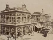
Ships dock at the main port in Manaus directly downtown on the banks of the Negro River. The terraced city is home to a network of bridged channels that divide it into several compartments. Several mobile phone companies have manufacturing plants in the port area, and other major electronics manufacturers also have plants there. Major exports going through the port include Brazil nuts, chemicals, petroleum, electrical equipment, and forest products. [citation needed]
العلاقات الدولية
بلدات توأم – مدن شقيقة
ماناوس متوأمة مع:
|
ملاحظات
المراجع
الهامش
- ^ IBGE 2020
- ^ About Manaus Archived 2009-07-01 at the Wayback Machine
- ^ "National Institute for Amazonia Research (INPA)". eubon.eu. Archived from the original on 2019-07-14. Retrieved 2019-07-14.
- ^ Heart of The Amazon and City of the Forest Archived 2009-06-14 at the Wayback Machine
- ^ "Manaus, Brazil - Amazon River Cruise Ship Port of Call". TripSavvy. Archived from the original on 2018-09-11. Retrieved 2019-02-05.
- ^ "Manaus - Encyclopedia.com". www.encyclopedia.com. Archived from the original on 2019-02-07. Retrieved 2019-02-05.
- ^ "Where Does the Amazon River Begin?". National Geographic News. 15 February 2014. Archived from the original on 27 March 2019. Retrieved 5 February 2019.
- ^ "Manaus" (PDF) (in الإنجليزية). ICMBio. Retrieved 19 January 2020.
- ^ "Normais Climatológicas Do Brasil 1981–2010" (in البرتغالية). Instituto Nacional de Meteorologia. Retrieved 26 October 2018.
- ^ "BDMEP - Série Histórica - Dados Diários - Temperatura Mínima (°C) - Manaus". Banco de Dados Meteorológicos para Ensino e Pesquisa. Instituto Nacional de Meteorologia. Retrieved 10 April 2014.
- ^ "BDMEP - Série Histórica - Dados Diários - Temperatura Máxima (°C) - Manaus". Banco de Dados Meteorológicos para Ensino e Pesquisa. Instituto Nacional de Meteorologia. Retrieved 10 April 2014.
- ^ "Station Manaus" (in الفرنسية). Meteo Climat. Retrieved 26 October 2018.
- ^ "LEI Nº 2.044, DE 16 DE OUTUBRO DE 2015" (PDF) (in البرتغالية). Archived (PDF) from the original on 1 February 2017. Retrieved 26 June 2017.
- ^ "Braga e Manaus reforçam cooperação estratégica" (in البرتغالية). Archived from the original on 20 August 2017. Retrieved 26 June 2017.
ببليوگرافيا عامة
وصلات خارجية
- Official website (in برتغالية)
مقالات متعلقة بماناوس | ||||||||||||||||||||||||||||||||||||||||||||||||||||||||||||
|---|---|---|---|---|---|---|---|---|---|---|---|---|---|---|---|---|---|---|---|---|---|---|---|---|---|---|---|---|---|---|---|---|---|---|---|---|---|---|---|---|---|---|---|---|---|---|---|---|---|---|---|---|---|---|---|---|---|---|---|---|
| ||||||||||||||||||||||||||||||||||||||||||||||||||||||||||||

- Pages using gadget WikiMiniAtlas
- CS1 البرتغالية-language sources (pt)
- CS1 الفرنسية-language sources (fr)
- Short description is different from Wikidata
- Articles with hatnote templates targeting a nonexistent page
- Pages using multiple image with auto scaled images
- Pages using multiple image with unknown parameters
- Articles containing Brazilian Portuguese-language text
- Coordinates on Wikidata
- Pages using infobox settlement with possible demonym list
- Pages using infobox settlement with unknown parameters
- Articles with unsourced statements from July 2017
- Articles with برتغالية-language sources (pt)
- ماناوس
- تأسيسات عقد 1660 في أمريكا الجنوبية
- تأسيسات 1669 في الامبراطورية البرتغالية
- Municipalities in Amazonas (Brazilian state)
- أماكن مأهولة تأسست في 1669
- أماكن مأهولة في أمازوناس (ولاية برازيلية)
- أماكن مأهولة على الأمازون
- أماكن مأهولة على الريو نگرو (الأمازون)
- Port cities in Brazil