كيرشهر
Kırşehir | |
|---|---|
 Kentpark in Kırşehir | |
 Kırşehir | |
| Coordinates: 39°08′44″N 34°09′39″E / 39.14556°N 34.16083°E | |
| Country | Turkey |
| Province | Kırşehir |
| Government | |
| • Mayor | Selahattin Ekicioğlu (CHP) |
| Area | |
| • District | 1٬677٫67 كم² (647٫75 ميل²) |
| Population (2012)[2] | |
| • Urban | 114٬244 |
| • District | 128٬806 |
| • District density | 77/km2 (200/sq mi) |
| Website | www.kirsehir.bel.tr |
كيرشهر، وكان اسمها في السابق: موكيسوس Mocissus [3] (باليونانية قديمة: Μωκισσός) and Justinianopolis[3] (Ἰουστινιανούπολις) هي عاصمة محافظة كيرشهر في تركيا وبلغ تعداد سكان قضائها في عام 2000، 121,947 نسمة، منهم 105,826 نسمة في المدينة.[4][5] The Mayor of Kırşehir is Selehattin Ekicioğlu.[6]
التاريخ

The history of Kırşehir dates back to the Hittites. During the period of the Hittites, the basin of Kırşehir was known as the country of "Ahiyuva", meaning "the Land of the Achaeans", as the Greeks were known to the Hittites. This basin also took the name Cappadocia at the time of the Romans and Byzantines.
Kırşehir was once known as Aquae Saravenae.[7] The Turks took the city in the 1070's and bestowed the current name. In Turkish, "Kır Şehri" means "steppe city" or "prairie city". It became the chief town of a sanjak in the Ottoman vilayet of Angora,[3] which possessed, ح. 1912, 8000 inhabitants, most of them Muslims.[8]
In the 19th century, Kırşehir was attached to the sanjak of Ankara. In the year 1921, Kırşehir was made capital of its own province. Kemal Atatürk visited the city in 1921 and 1931.
المباني والمنشآت التاريخية


Kesikköprü
Kesikköprü is one of the bridges built by Seljuk Empire in Middle Anatolia. It is on the way of Kırşehir-Konya, about 20 km (12.43 mi) to the south of Kırşehir, and across the River Kızılırmak with its 13 parts.
In the inscription of bridge, it is written that the bridge was built by Atabeg İzzü’d-Din Muhammed in 646 of the Hegira/1248 of the Christian era during the rule of Keykavus, the son of Keyhüsrev.
The ones who came from İzmir and tried to reach Sivas and Erzurum from Tokat passed over Kesikköprü. We have learned that the inscription was sunken into the river in 1953. In the 17th and 18th centuries, it took the name of Kesikköprü due to the fact that caravan roads were invaded by the highwaymen.
The three-line instruction destroyed on stone base can hardly be read.
النقش
"Ressame bi imaret hazihil el kantara el mübareke (fi eyyam han) devlet es sultan el azam İzzü-d dünya ve ‘d Din Ebul Feth Keykavus bin Keyhüsrev Burhan Emirel mü’münin."
"El Mevla el sahibul azam atabek el muazzam nazım mesalih il alem nasır el enam zübdetil eyyam izzeddin ebul meli Muhammed zahir Ali Selçuk ve emiril mü’minil azzellahu nasrahu ve ala kadrehu fi şuhuri sene sitte ve arbain ve sitte mie hamiden lillah ve musallian ala nebiihi Muhammed ve alihi vesellem teslimen kesiran."
ضريح عاشق پاشا
Aşık Pasha Mausoleum is the tomb of the 14-century sufi poet Aşık Pasha who died in 1332.[9]
التاريخ الكنسي


Metropolitan Archbishopric of Mocissus
Mocissus was also a Christian bishopric, and became a metropolitan see when, as Procopius (De ædif., V, iv) informs us, Justinian divided Cappadocia into three provinces and made this fortified site in north-western Cappadocia metropolis of Cappadocia Tertia, giving it the name of Justinianopolis.[8] Nothing else is known of its history, and its name should perhaps be written Mocessus. There is no doubt that the site of Mocissus, or Mocessus, is that which is occupied by the modern city of Kırşehir.[8] It figured in the Notitiæ episcopatuum until the 12th or 13th century.
Only a few of its bishops are known: the earliest, Peter, attended the Fifth Ecumenical Council (Second Council of Constantinople, 536);[مطلوب توضيح] the last, whose name is not known, was a Catholic, and was consecrated after the mid-15th century Catholic Council of Florence by Patriarch Metrophanes II of Constantinople.[8]
Titular see
The diocese was restored in 1895 as a titular archbishopric of the highest (Metropolitan) rank. It's vacant, having had the following incumbents:
- John Joseph Frederick Otto Zardetti (1895.05.25 – 1902.05.09)
- Giacomo Merizzi (1902.08.21 – 1916.03.22)
- Giovanni Battista Vinati (1916.07.31 – 1917.01.09)
- Adolf Fritzen (1919.07.31 – 1919.09.07)
- Lorenzo Schioppa (1920.08.20 – 1935.04.23)
- John Hugh MacDonald (1936.12.16 – 1938.03.05)
- Nicolas Cadi (1939.11.16 – 1941)
- Roger-Henri-Marie Beaussart (1943.12.10 – 1952.02.29)
- Vigilio Federico Dalla Zuanna, O.F.M. Cap. (1952.11.24 – 1956.03.04)
- Giovanni Jacono (1956.10.02 – 1957.05.26)
- Heinrich Wienken (1957.08.19 – 1961.01.21)
- Gabrijel Bukatko (1961.03.02 – 1964.03.24)
المناخ
Kırşehir has a continental climate (Köppen climate classification: Dsa, Trewartha climate classification: Dc), with cold, snowy winters and hot, dry summers. Light rainfall occurs year-round, except for late summer when rain is virtually absent.
| بيانات المناخ لـ كيرشهر (1991–2020, extremes 1930–2020) | |||||||||||||
|---|---|---|---|---|---|---|---|---|---|---|---|---|---|
| الشهر | ينا | فب | مار | أبر | ماي | يون | يول | أغس | سبت | أكت | نوف | ديس | السنة |
| القصوى القياسية °س (°ف) | 19.0 (66.2) |
20.6 (69.1) |
28.0 (82.4) |
30.9 (87.6) |
34.5 (94.1) |
36.2 (97.2) |
40.2 (104.4) |
40.5 (104.9) |
39.0 (102.2) |
33.6 (92.5) |
26.2 (79.2) |
19.9 (67.8) |
40.5 (104.9) |
| متوسط القصوى اليومية °س (°ف) | 4.9 (40.8) |
7.2 (45.0) |
12.2 (54.0) |
17.5 (63.5) |
22.5 (72.5) |
26.9 (80.4) |
30.7 (87.3) |
30.9 (87.6) |
26.7 (80.1) |
20.6 (69.1) |
13.0 (55.4) |
6.9 (44.4) |
18.3 (64.9) |
| المتوسط اليومي °س (°ف) | 0.1 (32.2) |
1.5 (34.7) |
5.9 (42.6) |
10.8 (51.4) |
15.7 (60.3) |
20.0 (68.0) |
23.7 (74.7) |
23.9 (75.0) |
19.2 (66.6) |
13.5 (56.3) |
6.5 (43.7) |
2.1 (35.8) |
11.9 (53.4) |
| متوسط الدنيا اليومية °س (°ف) | −3.8 (25.2) |
−3.0 (26.6) |
0.5 (32.9) |
4.7 (40.5) |
9.2 (48.6) |
13.2 (55.8) |
16.5 (61.7) |
16.8 (62.2) |
12.1 (53.8) |
7.2 (45.0) |
1.2 (34.2) |
−1.7 (28.9) |
6.1 (43.0) |
| الصغرى القياسية °س (°ف) | −28.0 (−18.4) |
−25.3 (−13.5) |
−21.8 (−7.2) |
−8.2 (17.2) |
−1.4 (29.5) |
2.6 (36.7) |
5.1 (41.2) |
5.0 (41.0) |
−1.2 (29.8) |
−6.6 (20.1) |
−21.5 (−6.7) |
−24.3 (−11.7) |
−28.0 (−18.4) |
| متوسط تساقط الأمطار mm (inches) | 43.8 (1.72) |
31.2 (1.23) |
37.9 (1.49) |
42.7 (1.68) |
46.2 (1.82) |
37.5 (1.48) |
8.9 (0.35) |
11.8 (0.46) |
14.9 (0.59) |
30.6 (1.20) |
35.0 (1.38) |
44.9 (1.77) |
385.4 (15.17) |
| Average precipitation days | 11.07 | 9.57 | 11.70 | 11.87 | 13.07 | 8.77 | 2.37 | 2.40 | 4.13 | 7.27 | 7.90 | 11.27 | 101.4 |
| Mean monthly ساعات سطوع الشمس | 102.3 | 130.0 | 176.7 | 210.0 | 272.8 | 318.0 | 368.9 | 347.2 | 288.0 | 226.3 | 165.0 | 102.3 | 2٬707٫5 |
| المتوسط اليومي ساعات سطوع الشمس | 3.3 | 4.6 | 5.7 | 7.0 | 8.8 | 10.6 | 11.9 | 11.2 | 9.6 | 7.3 | 5.5 | 3.3 | 7.4 |
| Source: Turkish State Meteorological Service[10] | |||||||||||||
أشخاص بارزون


- Uğur Mumcu, investigative journalist
- Haşim Kılıç, the President of the Constitutional Court of Turkey from October 22, 2007 until February 10, 2015
- Mustafa Bumin the President of the Constitutional Court of Turkey from May 31, 2000 until June 26, 2005
- Lütfi Müfit Özdeş, politician
- Osman Bölükbaşı, politician
- Deniz Bölükbaşı, politician
- Nezaket Ekici, artist
- Muharrem Ertaş, folk musician
- Şemsi Yastıman, folk musician
- Neşet Ertaş, folk poet
- Ahi Evren, preacher - died in Kırşehir
- Caca Bey, politician
- Asik Pasa, preacher, Turkish poet
- Silahdar Seyyid Mehmed Pasha 18th century Ottoman Grand Vizier
- Nuri Şahin, footballer
- Yasin Öztekin, footballer
معرض صور
-
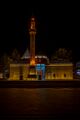 Ahi Evran Tomb
 -
 Ahi Evran Tomb
 -
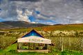 Apple farm in Kırşehir
 -
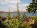 Cügün (Cogun) lake
 -
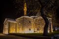
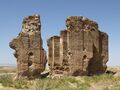 The ruins of the Üçayak Byzantine Church
.jpg&filetimestamp=20220428151555&)


الهامش
- ^ "Area of regions (including lakes), km²". Regional Statistics Database. Turkish Statistical Institute. 2002. Retrieved 2013-03-05.
- ^ "Population of province/district centers and towns/villages by districts - 2012". Address Based Population Registration System (ABPRS) Database. Turkish Statistical Institute. Retrieved 2013-02-27.
- ^ أ ب ت
 Chisholm, Hugh, ed. (1911). . دائرة المعارف البريطانية. Vol. 15 (eleventh ed.). Cambridge University Press. p. 834.
 {{cite encyclopedia}}: Cite has empty unknown parameter:|coauthors=(help) - ^ Turkish Statistical Institute. "Census 2000, Key statistics for urban areas of Turkey" (in التركية). Archived from the original (XLS) on 2007-07-22. Retrieved 2008-03-19.
- ^ GeoHive. "Statistical information on Turkey's administrative units". Retrieved 2008-03-19.
- ^ Gazete, Banka (21 November 2021). "Ankara'dan Kırşehir Belediyesi'ne destek". Gazete Banka. p. https://gazetebanka.com/. Retrieved 21 November 2021.
- ^ Lund University. Digital Atlas of the Roman Empire.
- ^ أ ب ت ث Pétridès, Sophron (1911). . In Herbermann, Charles (ed.). Catholic Encyclopedia. Vol. 10. New York: Robert Appleton Company.
- ^ Eyice, Semavi. "Âşık Paşa Türbesi" (in التركية). İslam Ansiklopedisi. Retrieved 1 May 2020.
- ^ "Resmi İstatistikler: İllerimize Ait Mevism Normalleri (1991–2020)" (in التركية). Turkish State Meteorological Service. Retrieved 6 July 2021.
![]() This article incorporates text from a publication now in the public domain: Smith, William, ed. (1854–1857). "Mocisus". Dictionary of Greek and Roman Geography. London: John Murray.
This article incorporates text from a publication now in the public domain: Smith, William, ed. (1854–1857). "Mocisus". Dictionary of Greek and Roman Geography. London: John Murray.
المراجع
- Falling Rain Genomics, Inc. "Geographical information on Kırşehir, Turkey". Retrieved 2008-03-18.
- District governor's official website (in إنگليزية)
وصلات خارجية
- GigaCatholic with titular incumbent biography links
- District governor's official website (in تركية)
- District municipality's official website (in تركية)
- Kirsehir Portal (in تركية)
| المقاطعات الريفية | ||
|---|---|---|
المناطق | ||
| إيجه | ||
| البحر الأسود | ||
| وسط الأناضول | ||
| شرق الأناضول | ||
| مرمرة | ||
| البحر المتوسط | ||
| جنوب شرق الأناضول | ||

- Pages using gadget WikiMiniAtlas
- مقالات المعرفة المحتوية على معلومات من دائرة المعارف البريطانية طبعة 1911
- CS1 التركية-language sources (tr)
- Articles incorporating a citation from the 1913 Catholic Encyclopedia with Wikisource reference
- Short description is different from Wikidata
- Coordinates on Wikidata
- Articles containing Ancient Greek (to 1453)-language text
- Articles with hatnote templates targeting a nonexistent page
- جميع الصفحات التي تحتاج تنظيف
- مقالات بالمعرفة تحتاج توضيح from July 2020
- Wikipedia articles incorporating a citation from the DGRG without Wikisource reference
- Wikipedia articles incorporating text from the DGRG
- Articles with إنگليزية-language sources (en)
- Official website different in Wikidata and Wikipedia
- Articles with تركية-language sources (tr)
- محافظة كيرشهر
- مدن تركيا
- منطقة وسط الأناضول
- كيرشهر
- مواقع رومانية في تركيا
- أقضية محافظة كيرشهر