كوتور
كوتور
Котор Cattaro | |
|---|---|
| Kotor | |
 | |
 Flag | |
 كوتور Location within Montenegro | |
| Coordinates: 42°25′48″N 18°46′12″E / 42.43000°N 18.77000°E | |
| البلد | |
| البلدية | |
| Founded | 5th century BC |
| Settlements | 56 |
| Government | |
| • Mayor | Vladimir Jokić (DCG) |
| • Ruling coalition | DCG-DF-SNP-URA |
| Area | |
| • Municipality | 335 كم² (129 ميل²) |
| Population (2011) | |
| • Rank | 9th in Montenegro |
| • Density | 68/km2 (180/sq mi) |
| • Urban | 12٬583 |
| • Rural | 10٬018 |
| • Municipality | 22٬601 |
| Time zone | UTC+1 (CET) |
| • Summer (DST) | UTC+2 (CEST) |
| Postal code | 85330 |
| Area code | +382 32 |
| ISO 3166-2 code | ME-10 |
| Car plates | KO |
| Website | www |
| موقع تراث عالمي لليونسكو | |
| جزء من | Natural and Culturo-Historical Region of Kotor |
| السمات | ثقافي: (i)(ii)(iii)(iv) |
| مراجع | 125ter |
| التدوين | 1979 (3rd Session) |
| الامتدادات | 2012, 2015 |

كوتور ( Kotor ؛ سيريلية الجبل الأسود: Котор ؛ تـُنطق [kɔ̌tɔr])، كانت تُعرف تاريخياً بإسم كتارو Cattaro[1][2][3] (from Italian: النطق بالإيطالية: [ˈkattaro]), is a coastal town in Montenegro. It is located in a secluded part of the Bay of Kotor. The city has a population of 13,510 and is the administrative center of Kotor Municipality.
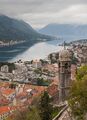
The old Mediterranean port of Kotor is surrounded by fortifications built during the Venetian period. It is located on the Bay of Kotor (Boka Kotorska), one of the most indented parts of the Adriatic Sea. Some have called it the southernmost fjord in Europe, but it is a ria, a submerged river canyon. Together with the nearly overhanging limestone cliffs of Orjen and Lovćen, Kotor and its surrounding area form an impressive landscape.
Since the early 2000s Kotor has seen an increase in tourists,[4] many of them coming by cruise ship. Visitors are attracted by the natural environment of the Gulf of Kotor and by the old town of Kotor. Kotor is part of the World Heritage Site dubbed the Natural and Culturo-Historical Region of Kotor.
The fortified city of Kotor was also included in UNESCO's World Heritage Site list as part of Venetian Works of Defence between 16th and 17th centuries: Stato da Terra – western Stato da Mar in 2017.[5]
التاريخ
التاريخ المبكر

Once populated by the Illyrians, the exact time of foundation of the first settlement is not known. According to some sources, the oldest settled area dates two millennia back.
The town, first mentioned in 168 BC, was settled during Ancient Roman times, when it was known as Acruvium, Ascrivium, or Ascruvium (باليونانية قديمة: Ἀσκρήβιον) and was part of the Roman province of Dalmatia.[6]
العصور الوسطى
The town has been fortified since the early Middle Ages, when Emperor Justinian built a fortress above Ascrivium in 535, after expelling the Ostrogoths.[citation needed] Ascrivium was plundered by the Saracens in 840. It was further fortified towards the peak of Saint Ivan by Constantine VII Porphyrogennetos in the 10th century.[citation needed] It was one of the more influential Dalmatian city-states, initially with a Romance-speaking population, as throughout the early Middle Ages, and until the 11th century the Dalmatian language was still spoken in Kotor.[citation needed] The city was part of Byzantine Dalmatia in that period, and the modern name of Kotor probably originated in the Byzantine name for the town: Dekatera or Dekaderon.[citation needed]
In 1002, the city suffered damage under the occupation of the First Bulgarian Empire,[citation needed] and in the following year it was ceded to Duklja by the Bulgarian Tsar Samuil.[citation needed] Duklja, or Dioclea, was a vassal duchy of Byzantium at the time. The local population resisted the pact and, taking advantage of its alliance with Dubrovnik, maintained its high autonomy. Duklja, the biggest Serb duchy at the time, gradually became more powerful under Vojislavljević dynasty and eventually independent from Byzantium in 1042. The city remained autonomous up until Duklja was once again subdued by Byzantium in 1143.[بحاجة لمصدر]
The city was conquered in 1185 by Stefan Nemanja, the ruler of the Grand Principality of Serbia and founder of the Nemanjić dynasty. At that time Kotor was already an episcopal see subordinated to the archbishopric of Bari, and in 13th century, Dominican and Franciscan monasteries were established to check the spread of Bogomilism.[citation needed] Under the rule of the Nemanjić Kotor became a partially autonomous city, enjoying many privileges and maintaining its republican institutions. This is backed by a statute from 1301, which demonstrates that Kotor had the status of a city under Serbian rule. In the 14th century the commerce of Cattaro, as named in Latin scripts (in Serbian Котор, град краљев/Kotor, city of the King), rivaled that of Republic of Ragusa, and caused the Republic of Venice to be envious. Kotor remained the most important trading port of subsequent Serb states – Kingdom of Serbia and Serbian Empire, up to its downfall in 1371.[بحاجة لمصدر]
After the fracturing of the Serbian Empire, the city was taken by the Kingdom of Hungary, only to change hands repeatedly between them and the Republic of Venice in the period between 1371 and 1384.[citation needed] After that, Kotor was held by the Kingdom of Bosnia [citation needed] under Tvrtko I Kotromanić between 1384 and 1391. The king of Bosnia,[citation needed] who claimed the Serbian throne, minted his coins in Kotor.[بحاجة لمصدر]
After the death of Tvrtko in 1391, Kotor became fully independent, until the administration, wary of the looming Ottoman danger, asked the Republic of Venice for protection. The city acknowledged the suzerainty of the Republic of Venice in 1420.[citation needed]
حكم البندقية

المدينة كانت جزءاً من مقاطعة ألبانيا البندقية [citation needed] ضمن جمهورية البندقية من 1420 إلى 1797.[citation needed]
Four centuries of Venetian domination have given the city the typical Venetian architecture, that contributes to make Kotor a UNESCO world heritage site.[7]
In the 14th and 15th centuries, there was an influx of settlers from the oblasts of Trebinje (the region around forts Klobuk Ledenica and Rudina) and the Hum lands (Gacko and Dabar) to Kotor.[8] The Italian name of the city is Cattaro. Under Venetian rule, Kotor was besieged by the Ottoman Empire in 1538 and 1657, endured the plague in 1572, and was nearly destroyed by earthquakes in 1563 and 1667.
حكم الهابسبورگ ثم ناپليون

After the Treaty of Campo Formio in 1797, it passed to the Habsburg monarchy. However, in 1805, it was assigned to the French Empire's client state, the Napoleonic Kingdom of Italy, by the Treaty of Pressburg, although in fact held by a Russian squadron under Dmitry Senyavin. After the Russians retreated, Kotor was united in 1806 with this Kingdom of Italy and then in 1810 with the French Empire's Illyrian Provinces. Kotor was captured by the British in an attack on the Bay led by Commodore John Harper in the brig sloop إتشإمإس Saracen (18 guns). To seal off Kotor, residents along the shore literally pulled the ship in windless conditions with ropes. The Saracen's crew later hauled naval 18-pounder guns above Fort St. John, the fortress near Kotor, and were reinforced by Captain William Hoste with his ship إتشإمإس Bacchante (38 guns). The French garrison had no alternative but to surrender, which it did on 5 January 1814.
It was restored to the Habsburg monarchy by the Congress of Vienna. Until 1918, the town, then known as Cattaro, was head of the district of the same name, one of the 13 Bezirkshauptmannschaften in the Kingdom of Dalmatia.[9]
الحرب العالمية الأولى
During World War I, Cattaro was one of three main bases of the Austro-Hungarian Navy, the home port of the Austrian Fifth Fleet, consisting of pre-dreadnought battleships and light cruisers, and a base for Austrian and German submarines.[citation needed]
The area was the site of some of the fiercest battles between local Montenegrins and Austria-Hungary. After 1918, the city became a part of Yugoslavia and officially became known as Kotor.
الحرب العالمية الثانية
Between 1941 and 1943 the Kingdom of Italy annexed the area of Kotor which became one of three provinces of the Italian Governorate of Dalmatia – the Province of Cattaro[10] had an area (subdivided in 15 "Comuni") of 547 km2 and a population of 39,800 inhabitants. Most of the city's inhabitants were Orthodox (with some Roman Catholics). After the war the remaining members of Dalmatian Italians of Kotor (300 inhabitants) left Yugoslavia towards Italy (Istrian-Dalmatian exodus).[11]
المعالم الرئيسية

Kotor has one of the best preserved medieval old towns in the Adriatic and is a double Unesco World Heritage Site: it is part of Natural and Culturo-Historical Region of Kotor and Venetian Works of Defence between the 16th and 17th centuries: Stato da Terra – western Stato da Mar.[7]
It is home to numerous sights, such as the Cathedral of Saint Tryphon in the old town (built in 1166), and the ancient walls which stretch for 4.5 km (3 mi) directly above the city. Sveti Đorđe and Gospa od Škrpijela islets off the coast of Perast are also among the tourism destinations in the vicinity of Kotor.
الثقافة

Kotor hosts several summer events, such as the Summer Carnival or Bokeljska Noć. Together with Budva, and the small town of Tuzi, near Podgorica, the city hosted the Federation of European Carnival Cities (FECC) World Carnival City Congress in May 2009.
Kotor Festival of Theatre for Children is one of the most important festivals of its kind in Southeast Europe.[12] Thirty years of this manifestation have marked performances by artists from over 30 countries, from 5 different continents. It was founded in 1993, not far from the place where the first play for children in the Balkans was performed in 1829. The 2017/18 festival was awarded the EFFE Label by the EFA (European Festivals Association).[13] Kotor Festival is highly regarded in the local community and has a large volunteer base.
Kotor has a large population of cats that have become a symbol of the city.[14] The city has several cat stores and a cat museum, as well as the Cats' Square (Trg od mačaka).[15] Water and food is left throughout the city for the cats to feed on, and cardboard boxes are often arranged to be a place for the cats to sleep in.[16] Tourists may notice cats in poor health, which may be due to malnutrition, lack of shelter, fighting, or illness (often a common viral respiratory condition for which medicine is unavailable).[17] The charity Kotor Kitties [18] exists to try and help the cats of Kotor through spaying and neutering. Kotor is described evocatively at the beginning of Marguerite Yourcenar's story 'Marko's Smile.'
السكان
Kotor is the administrative centre of Kotor municipality, which includes the towns of Risan and Perast, as well as many small hamlets around the Bay of Kotor, and has a population of 22,601.[19]
The town of Kotor itself has 961 inhabitants, but the administrative limits of the town encompass only the area of the Old Town. The urban area of Kotor also includes Dobrota (8,819) and Škaljari (3,807), bringing the population of Kotor's urban area close to 13,000 inhabitants. The total number rises to around 15,000 if the neighbouring hamlets of Muo, Prčanj and Stoliv are included. The entire population of Kotor Municipality was 22,947, as of the 2003 census.
Ethnic composition of the municipality in 2011:[19]
| Ethnicity | Number | Percentage |
|---|---|---|
| Montenegrins | 11,047 | 48.88% |
| Serbs | 6,910 | 30.57% |
| Croats | 1,553 | 6.87% |
| Other/undeclared | 3,091 | 13.68% |
| Total | 22,601 | 100% |
Until the 19th century the main language of Kotor was Italian.[20] During the 19th century, the use of Italian began to decline in favour of Serbian. In 1890, the 18.7% of the population was Italian. The majority of the Italian minority left the city for Italy after the Treaty of Rapallo (1920). The remaining Italians were assimilated or left Kotor after 1945. Today, only 31 people in Kotor identify as ethnic Italians.[21][22] According to documents from 1900, Kotor had 7,617 Catholics, and 7,207 Orthodox Christians. Kotor is still the seat of the Catholic Bishopric of Kotor, which covers the entire gulf. In 2011, 78% citizens of Kotor were Orthodox Christians, while 12% were listed as Roman Catholic.
-
 Orthodox Church of St. Nicholas
 -
 Church of Our Lady of Health
 -
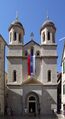
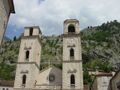 Cathedral of Saint Tryphon (Sv. Tripun)
 -
 Blessed Ozana Church


-
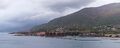
 The narrow inlet to the Bay of Kotor.
 -
 Defense position at the inlet of the Bay of Kotor.
 -
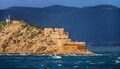
 A fortified island in the Bay of Kotor.
 -
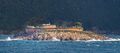
 Typical geography around the Bay of Kotor.
.jpg&filetimestamp=20230403164559&)
.jpg&filetimestamp=20230403164554&)
.jpg&filetimestamp=20230403164548&)
الرياضة
The local football team is FK Bokelj, who have spent several seasons in the country's top and second tiers. They play their home games at the Stadion pod Vrmcem.
Kotor is a national powerhouse of water polo, which is a popular sport in Montenegro. The team of Primorac Kotor won the LEN Champions League in 2009. Another club from Kotor, VA Cattaro, won the 2010 edition of the LEN Euro Cup.
النقل
Kotor is connected to the Adriatic Highway and the rest of the coast and inland Montenegro by Vrmac Tunnel. Inland is reachable by detouring from Adriatic highway at Budva or Sutomore (through Sozina tunnel). There is also a historic road connecting Kotor with Cetinje, which has views of Kotor bay.
Tivat Airport is 5 كيلومتر (3.1 mi) away, and there are regular flights to Belgrade, Moscow, Paris and London. Dozens of charter planes land daily on Tivat airport during the summer season.
Podgorica Airport is 65 كيلومتر (40 mi) away, and it has regular flights to major European destinations throughout the year.
Twin towns - sister cities
Kotor is twinned with:[23][24][25]
 Děčín، جمهورية التشيك
 Campomarino، إيطاليا
 Nesebar, Bulgaria
- Přerov، جمهورية التشيك
 Santa Barbara، الولايات المتحدة
 Stari Grad (Belgrade)، صربيا
- Subotica، صربيا
 سگد، المجر
 تروگير، كرواتيا
انظر أيضاً
المراجع
- ^ "Kotor - a fairy-tale medieval town". Retrieved 19 December 2022.
- ^ Robinson, J. (1807). "The New Annual Register, Or, General Repository of History, Politics, and Literature for the Year". p. 272. Retrieved 19 December 2022.
- ^ Gifford, C.H. "History of the wars occasioned by the French Revolution from 1792 to 1816 - With numerous embellishments". p. 504. Retrieved 19 December 2022.
- ^ World Travel and Tourism Council
- ^ Centre, UNESCO World Heritage. "Venetian Works of Defence between 16th and 17th centuries: Stato da Terra – western Stato da Mar". whc.unesco.org (in الإنجليزية). Retrieved 11 July 2017.
- ^ Jackson, Hamilton (2010). The Shores of the Adriatic (Illustrated ed.). Echo Library. p. 269. ISBN 978-1-4068-6761-9. Retrieved 21 February 2011.
- ^ أ ب "Natural and Culturo-Historical Region of Kotor". Unesco World Heritage Convention. Retrieved 5 December 2016.
- ^ Tošić, Đuro. Trebinjci i Zahumljani u srednjovjekovnom Kotoru Archived 2012-03-17 at the Wayback Machine, work in Istraživanja, 2005, br. 16, pp. 221–27.
- ^ Die postalischen Abstempelungen auf den österreichischen Postwertzeichen-Ausgaben 1867, 1883 und 1890, Wilhelm KLEIN, 1967
- ^ "Bollettino ufficiale legislazione e disposizioni ufficiali" (in الإيطالية). p. 441. Retrieved 4 July 2022.
- ^ Rodogno, Davide (2003). Il nuovo ordine mediterraneo. Turin: Bollati Boringhieri.
- ^ "Kotor Festival of Theatre for Children". Retrieved 18 April 2022.
- ^ "EFFE Label for Kotor Festival of Theatre for Children". Retrieved 18 April 2022.
- ^ "Cats in Kotor Old Town, Montenegro". Retrieved 4 October 2018.
- ^ "The Bizarre History of Kotor's Fascination With Cats". Retrieved 4 October 2018.
- ^ "MONTENEGRO IS FOR THE CATS". Retrieved 4 October 2018.
- ^ "Cat Welfare In Kotor". Retrieved 8 June 2020.
- ^ "Kotor Kitties". Retrieved 6 February 2021.
- ^ أ ب "Montenegrin 2011 census". Monstat. 2011.
- ^ Le bocche di Cattaro nel 1810: con notizie sul Montenegro : relazione di Luigi Paulucci, delegato napoleonico, con altri documenti e appunti di storia "bocchese" : biografie dei Marchesi Paulucci, nei loro legami dalmati, veneti, piemontesi e russi
- ^ Guerrino Perselli, I censimenti della popolazione dell'Istria, con Fiume e Trieste e di alcune città della Dalmazia tra il 1850 e il 1936, Centro di Ricerche Storiche - Rovigno, Unione Italiana - Fiume, Università Popolare di Trieste, Trieste-Rovigno, 1993
- ^ http://monstat.org/userfiles/file/popis2011/saopstenje/saopstenje(1).pdf [bare URL PDF]
- ^ "International relations". kotor.me. Kotor. Retrieved 2019-12-29.
- ^ "Partnerská města - město Přerov". prerov.eu (in التشيكية). Město Přerov. Retrieved 2019-12-29.
- ^ "Bratimljenje" (PDF). database.uom.me (in Montenegrin). Zajednica opština Crne Gore. January 2013. p. 29. Retrieved 2019-12-29.
وصلات خارجية
- Official website
- Visit-Montenegro: Kotor-History
- UNESCO: Natural and Culturo-Historical Region of Kotor
- CS1 الإيطالية-language sources (it)
- All articles with bare URLs for citations
- Articles with bare URLs for citations from March 2022
- Articles with PDF format bare URLs for citations
- CS1 التشيكية-language sources (cs)
- CS1 foreign language sources (ISO 639-2)
- Short description is different from Wikidata
- Articles with hatnote templates targeting a nonexistent page
- Missing redirects
- Pages using gadget WikiMiniAtlas
- Articles containing Ancient Greek (to 1453)-language text
- Articles with unsourced statements from January 2020
- مقالات ذات عبارات بحاجة لمصادر
- Articles with unsourced statements from April 2022
- Official website different in Wikidata and Wikipedia
- كوتور
- أماكن مأهولة في بلدية كوتور
- الجبل الأسود الإليري
- مدن في إليريا القديمة
- مملكة دلماتيا