شبه الجزيرة العليا لمشيگن
Upper Peninsula | |
|---|---|
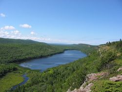
 The Lake of the Clouds in the Porcupine Mountains of the Upper Peninsula of Michigan | |
| الكنية: The UP | |
 | |
| الإحداثيات: 46°14′00″N 86°21′00″W / 46.23333°N 86.35000°W | |
| Country | United States |
| State | Michigan |
| المساحة | |
| • الإجمالي | 16٬377 ميل² (42٬420 كم²) |
| التعداد (2010) | |
| • الإجمالي | 311٬361 |
| • الكثافة | 19/sq mi (7٫3/km2) |
| منطقة التوقيت | |
| most of the Upper Peninsula | UTC−05:00 (Eastern) |
| • الصيف (التوقيت الصيفي) | UTC−04:00 (EDT) |
| four counties bordering Wisconsin (Gogebic, Iron, Dickinson, and Menominee) | UTC−06:00 (Central) |
| • Summer (DST) | UTC−05:00 (CDT) |
| مفتاح الهاتف | 906 |
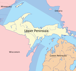
The Upper Peninsula (UP), also known as Upper Michigan, is the northern of the two major peninsulas that make up the U.S. state of Michigan. The peninsula is bounded on the north by Lake Superior, on the east by the St. Marys River, and on the south by Lake Michigan, the Straits of Mackinac, and Lake Huron. Topographically, the base of the Upper Peninsula as a geologic feature lies in northeastern Wisconsin between the base of the Door Peninsula and Superior Bay; but in political geography, because most of the peninsula is within the boundaries of Michigan, it is measured eastward from the Porcupine Mountains, from the Wisconsin–Michigan boundary along and between the Montreal and Menominee rivers.
Michigan's Upper Peninsula is bounded on land by Wisconsin to the southwest and west; and in territorial waters by Minnesota to the west, Ontario to the west, north and east, and the Door Peninsula of Wisconsin extends into Lake Michigan east of the western Upper Peninsula. Five Michigan Upper Peninsula counties include nearby major islands: Mackinac Island, Round Island and Bois Blanc Island in Lake Huron are in Mackinac County; Sugar Island and Neebish Island in the St. Marys River, and Drummond Island in Lake Huron are in Chippewa County; Grand Island is in Alger County; Summer Island is Delta County; and Isle Royale is part of Keweenaw County.
The Upper Peninsula contains 29% of the land area of Michigan but just 3% of its total population. Residents are frequently called Yoopers (derived from "U.P.-ers") and have a strong regional identity. Large numbers of French Canadian, Finnish, Swedish, Cornish, and Italian immigrants came to the Upper Peninsula, especially the Keweenaw Peninsula, to work in the area's mines and lumber industry. The peninsula includes the only counties in the United States where a plurality of residents claim Finnish ancestry.[1]
The peninsula's largest cities are Marquette, Sault Ste. Marie, Escanaba, Menominee, Houghton, and Iron Mountain. The heavily forested land, soil types, short growing season and logistical factors (e.g. long distance to market, lack of infrastructure, etc.) make the Upper Peninsula poorly suited for agriculture. The economy is based primarily on logging and tourism; mineral mining - mainly iron, gold and copper - was a major industry during a "golden age" from 1890 to 1920.
التاريخ
الجغرافيا
الحياة البرية
المناخ
مناطق التوقيت
Like the entire Lower Peninsula, most of the Upper Peninsula observes Eastern Time. However, the four counties bordering Wisconsin are in the Central Time zone.
Government
There are 15 counties in the Upper Peninsula.
State prisons are located in Baraga, Marquette, Munising, Newberry, Marenisco and Kincheloe.
Politics
| County | Registered voters | Votes cast | Romney/Ryan | Obama/Biden | Result |
|---|---|---|---|---|---|
| Alger | 4,671 | 4,618 | 2,330 | 2,212 | REP |
| Baraga | 3,540 | 3,490 | 1,866 | 1,574 | REP |
| Chippewa | 15,790 | 15,564 | 8,278 | 7,100 | REP |
| Delta | 18,968 | 18,050 | 9,534 | 8,330 | REP |
| Dickinson | 12,950 | 12,810 | 7,688 | 4,952 | REP |
| Gogebic | 7,689 | 7,576 | 3,444 | 4,058 | DEM |
| Houghton | 15,477 | 15,282 | 8,196 | 6,801 | REP |
| Iron | 6,065 | 5,988 | 3,224 | 2,687 | REP |
| Keweenaw | 1,411 | 1,392 | 774 | 582 | REP |
| Luce | 3,401 | 2,596 | 1,580 | 991 | REP |
| Mackinac | 6,170 | 6,099 | 3,397 | 2,652 | REP |
| Marquette | 32,551 | 32,194 | 13,606 | 18,115 | DEM |
| Menominee | 11,043 | 10,923 | 5,564 | 5,242 | REP |
| Ontonagon | 3,599 | 3,539 | 1,906 | 1,586 | REP |
| Schoolcraft | 4,104 | 4,048 | 2,142 | 1,865 | REP |
| Total | 147,429 | 144,168 | 73,529 | 70,639 | REP |
All counties in the U.P. are part of Michigan's 1st congressional district. Jack Bergman, a Republican, has been the U.S. Representative for this district since January 2017.
| Year | REP | DEM | Others |
|---|---|---|---|
| 2016[5] | 56.40% 82,018 | 37.77% 54,923 | 5.83% 8,476 |
| 2012[6] | 50.80% 73,529 | 47.49% 68,747 | 1.71% 2,477 |
| 2008[7] | 46.12% 69,647 | 51.82% 78,257 | 2.06% 3,108 |
| 2004[8] | 51.52% 78,276 | 47.31% 71,888 | 1.17% 1,781 |
| 2000[9] | 50.61% 70,256 | 45.95% 63,791 | 3.43% 4,768 |
In Michigan's 2010 gubernatorial election Republican Rick Snyder carried every U.P. county but one, Gogebic, on his way to victory over his Democratic opponent, Virg Bernero.[10]
Proposed statehood
Due to the geographic separation and perceived cultural and political differences from the Lower Peninsula, at various times there have been proposals for the Upper Peninsula to secede from Michigan as a 51st state named Superior, sometimes including portions of northern Wisconsin and/or the northern Lower Peninsula. Several prominent legislators, including the region's long-serving state representative Dominic Jacobetti, attempted unsuccessfully to gain passage of such a bill in the 1970s.[11] It would be the least populous state in the union, and as stronger connections to the rest of Michigan have developed since completion of the Mackinac Bridge in the 1950s, the proposal's future is unclear.[12]
السكان
According to the 2010 census, 103,211 people live in the 12 towns of at least 4,000 people, covering 96.5 ميل مربع (250 km2). A total of 116,548 people live in the 18 towns and villages of at least 2,000 people, which cover 108.5 ميل مربع (281 km2)—less than 1% of the peninsula's land area.
|
|
| County | 1830 | 1840 | 1850 | 1860 | 1870 | 1880 | 1890 | 1900 | 1910 | 1920 | 1930 | 1940 | 1950 | 1960 | 1970 | 1980 | 1990 | 2000 | 2010 |
|---|---|---|---|---|---|---|---|---|---|---|---|---|---|---|---|---|---|---|---|
| Alger | — | — | — | — | — | — | 1,238▲ | 5,868▲ | 7,675▲ | 9,983▲ | 9,327 |
10,167▲ | 10,007 |
9,250 |
8,568 |
9,225▲ | 8,972 |
9,862▲ | 9,601 |
| Baraga | — | — | — | — | — | 1,804▲ | 3,036▲ | 4,320▲ | 6,125▲ | 7,662▲ | 9,168▲ | 9,356▲ | 8,037 |
7,151 |
7,789▲ | 8,484▲ | 7,954 |
8,735▲ | 8,860▲ |
| Chippewa | 626▲ | 534 |
898▲ | 1,603▲ | 1,689▲ | 5,248▲ | 12,018▲ | 21,338▲ | 24,472▲ | 24,818▲ | 25,047▲ | 27,807▲ | 29,206▲ | 32,655▲ | 32,412 |
29,029 |
34,604▲ | 38,543▲ | 38,520 |
| Delta | — | — | — | 1,172▲ | 2,542▲ | 6,812▲ | 15,330▲ | 23,881▲ | 30,108▲ | 30,909▲ | 32,280▲ | 34,037▲ | 32,913 |
34,298▲ | 35,924▲ | 38,947▲ | 37,780 |
38,520▲ | 37,069 |
| Dickinson | — | — | — | — | — | — | — | 17,890▲ | 20,524▲ | 19,456 |
29,941▲ | 28,731 |
24,844 |
23,917 |
23,753 |
25,341▲ | 26,831▲ | 27,427▲ | 26,168 |
| Gogebic | — | — | — | — | — | — | 13,166▲ | 16,738▲ | 23,333▲ | 33,225▲ | 31,577 |
31,797▲ | 27,053 |
24,370 |
20,676 |
19,686 |
18,052 |
17,370 |
16,427 |
| Houghton | — | — | 708▲ | 9,234▲ | 13,879▲ | 22,473▲ | 35,389▲ | 66,063▲ | 88,098▲ | 71,930 |
52,851 |
47,631 |
39,771 |
34,654 |
34,652 |
37,872▲ | 35,446 |
36,016▲ | 36,628▲ |
| Iron | — | — | — | — | — | — | 4,432▲ | 8,990▲ | 15,164▲ | 22,107▲ | 20,805 |
20,243 |
17,692 |
17,184 |
13,813 |
13,635 |
13,175 |
13,138 |
11,817 |
| Keweenaw | — | — | — | — | 4,205▲ | 4,270▲ | 2,894 |
3,217▲ | 7,156▲ | 6,322 |
5,076 |
4,004 |
2,918 |
2,417 |
2,264 |
1,963 |
1,701 |
2,301▲ | 2,156 |
| Luce | — | — | — | — | — | — | 2,455▲ | 2,983▲ | 4,004▲ | 6,149▲ | 6,528▲ | 7,423▲ | 8,147▲ | 7,827 |
6,789 |
6,659 |
5,763 |
7,024▲ | 6,631 |
| Mackinac | 877▲ | 923▲ | 3,598▲ | 1,938 |
1,716 |
2,902▲ | 7,830▲ | 7,703 |
9,249▲ | 8,026 |
8,783▲ | 9,438▲ | 9,287 |
10,853▲ | 9,660 |
10,178▲ | 10,674▲ | 11,943▲ | 11,113 |
| Marquette | — | — | 136▲ | 2,821▲ | 15,033▲ | 25,394▲ | 39,521▲ | 41,239▲ | 46,739▲ | 45,786 |
44,076 |
47,144▲ | 47,654▲ | 56,154▲ | 64,686▲ | 74,101▲ | 70,887 |
64,634 |
67,077▲ |
| Menominee | — | — | — | — | 1,791▲ | 11,987▲ | 33,639▲ | 27,046 |
25,648 |
23,778 |
23,652 |
24,883▲ | 25,299▲ | 24,685 |
24,587 |
26,201▲ | 24,920 |
25,109▲ | 24,029 |
| Ontonagon | — | — | 389▲ | 4,568▲ | 2,845 |
2,565 |
3,756▲ | 6,197▲ | 8,650▲ | 12,428▲ | 11,114 |
11,359▲ | 10,282 |
10,584▲ | 10,548 |
9,861 |
8,854 |
7,818 |
6,780 |
| Schoolcraft | — | — | 16▲ | 78▲ | — | 1,575▲ | 5,818▲ | 7,889▲ | 8,681▲ | 9,977▲ | 8,451 |
9,524▲ | 9,148 |
8,953 |
8,226 |
8,575▲ | 8,302 |
8,903▲ | 8,485 |
| Total | 1,503▲ | 1,457 |
5,745▲ | 21,414▲ | 43,700▲ | 85,030▲ | 180,522▲ | 261,362▲ | 325,626▲ | 332,556▲ | 318,676 |
323,544▲ | 302,258 |
304,952▲ | 304,347 |
319,757▲ | 313,915 |
317,213▲ | 311,361 |
Economy
Industries

See also
- List of counties in Michigan
- Heikki Lunta, mythological character
- Stormy Kromer cap
Notes
References
- ^ Simon, James; Finney, Patricia (أغسطس 10–14, 2008). "Publication, Access and Preservation of Scandinavian Immigrant Press in North America" (PDF). Quebec: Center for Research Libraries. Retrieved أكتوبر 27, 2010.
{{cite web}}: Unknown parameter|last-author-amp=ignored (|name-list-style=suggested) (help) - ^ "Archived copy". Archived from the original on فبراير 18, 2013. Retrieved يونيو 3, 2013.
{{cite web}}: CS1 maint: archived copy as title (link) - ^ "Archived copy". Archived from the original on مايو 18, 2013. Retrieved يونيو 3, 2013.
{{cite web}}: CS1 maint: archived copy as title (link) - ^ "Dave Leip's Atlas of U.S. Presidential Elections". Retrieved ديسمبر 19, 2016.
- ^ "Election results". uselectionatlas.org. 2016.
- ^ "Election results". uselectionatlas.org. 2012.
- ^ "Election results". uselectionatlas.org. 2008.
- ^ "Election results". uselectionatlas.org. 2004.
- ^ "Election results". uselectionatlas.org. 2000.
- ^ "Archived copy". Archived from the original on يناير 21, 2013. Retrieved يناير 3, 2013.
{{cite web}}: CS1 maint: archived copy as title (link) - ^ "The Dominic J. Jacobetti Collection". Archived from the original on سبتمبر 7, 2006. Retrieved نوفمبر 6, 2006.
- ^ Hart, John; Jamieson, Bob (أغسطس 8, 1975). "Headline: 51st State". NBC Evening News. Retrieved نوفمبر 6, 2006.
{{cite news}}: Unknown parameter|last-author-amp=ignored (|name-list-style=suggested) (help) - ^ خطأ استشهاد: وسم
<ref>غير صحيح؛ لا نص تم توفيره للمراجع المسماةAmerican Fact Finder, Census 2010 - ^ خطأ استشهاد: وسم
<ref>غير صحيح؛ لا نص تم توفيره للمراجع المسماةgazetteer
Further reading
- Burt, Williams A.; Hubbard, Bela (1846). Reports on the Mineral Region of Lake Superior. Buffalo: L. Danforth. ISBN 0-665-51009-8.
{{cite book}}: Unknown parameter|last-author-amp=ignored (|name-list-style=suggested) (help) 113 pages. - Harrison, Jim (نوفمبر 30, 2013). "Imprint: My Upper Peninsula". The New York Times. Retrieved نوفمبر 30, 2013.
- Lankton, Larry (2010). Hollowed Ground: Copper Mining and Community Building on Lake Superior, 1840s–1990s. Detroit: Wayne State University Press. 376 pages.
- Magnaghi, Russell M.; Marsden, Michael T., eds. (1997). A Sense of Place: Michigan’s Upper Peninsula: Essays in Honor of William and Margery Vandament. Northern Michigan University Press. ISBN 0-918616-20-4.
{{cite book}}: Unknown parameter|last-author-amp=ignored (|name-list-style=suggested) (help) 270 pages.
External links
- Clarke Historical Library, Central Michigan University, Bibliography on Michigan, arranged by counties and regions
- Great Lakes Coast Watch
- Michigan Department of Natural Resources website, harbors, hunting, resources and more
- Map of Upper Peninsula Counties and Minor Civil Divisions
- Michigan Historic Markers
- Michigan's Official Economic Development and Travel Site, including interactive map, information on attractions, museums, etc.
- Upper Peninsula of Michigan Nature Tourism | The Great Waters of Michigan
- Upper Peninsula of Michigan Travel
- Western Upper Peninsula of Michigan
- Finland Calling the WLUC TV-6 weekly Sunday morning show that has aired since 1962, hosted by Carl Pellonpaa.
- The Upper Peninsula in the Civil War
- Pages using gadget WikiMiniAtlas
- CS1 errors: unsupported parameter
- Articles with hatnote templates targeting a nonexistent page
- Missing redirects
- Use American English from October 2019
- All Wikipedia articles written in American English
- Use mdy dates from September 2012
- Short description is different from Wikidata
- Coordinates on Wikidata
- Pages with empty portal template
- Upper Peninsula of Michigan
- Regions of Michigan


