الجبال الاسكندناڤية
| الجبال الاسكندناڤية | |
|---|---|
| Scandinavian Mountains | |
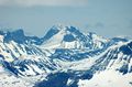
 جبل آكـّا في سارك، المنتزه الوطني، شمال السويد | |
| أعلى نقطة | |
| القمة | گالدوپگن, لوم |
| الارتفاع | 2،469 m (8،100 ft)[1] |
| الإحداثيات | 61°38′11″N 08°18′45″E / 61.63639°N 8.31250°E |
| الأبعاد | |
| الطول | 1،700 km (1،100 mi)[2] |
| العرض | 320 km (200 mi)[2] |
| التسمية | |
| Skanderna, Fjällen, Kjølen, Köli, Skandit (سويدية) | |
| الجغرافيا | |
 The Scandinavian Mountains | |
| البلدان | النرويج, السويد and فنلندا |
| نطاق الإحداثيات | 65°N 14°E / 65°N 14°E |
سلسلة الجبال الإسكندنافية أو سكاندس Scandes بالسويدية، تقع في شبه الجزيرة الإسكندنافية. شديدة الانحدار من الناحية الغربية المواجهة لبحر الشمال مشكلة ممرات النرويج البحرية الشهيرة. يشكل الجزء الشمالي من الجبال حدودا طبيعية لكل من النروج وفنلندا والسويد.

ارتفاع السلسلة ليس بكبير فأعلى قممها -قمة گالدوپگن Galdhøpiggen في النرويج- يصل ارتفاعها لـ 2,469 م وأعلى ارتفاع لها في السويد هي قمة كبنكايسه Kebnekaise ويصل ارتفاعها لـ 2,103 م.
| جزء من سلسلة عن |
| اسكندناڤيا |
|---|
 |
|
|
المناخ والأرض دائمة التجلد والمثالج

The climate of the Nordic countries is maritime along the coast of Norway, and much more continental in Sweden in the rain shadow of the Scandinavian Mountains. The combination of a northerly location and moisture from the North Atlantic Ocean has caused the formation of many ice fields and glaciers. In the mountains, the air temperature decreases with increasing altitude, and patches of mountain permafrost in regions with a mean annual air temperature (MAAT) of -1.5°C will be found at wind exposed sites with little snow cover during winter. Higher up, widespread permafrost may be expected at altitudes with a MAAT of -3.5°C, continuous permafrost at altitudes with a MAAT of -6.0°C.[3]
الجيولوجيا
الركيزة الجيولوجية


Most of the rocks of the Scandinavian Mountains are Caledonian, which means they were put in place by the Caledonian orogeny. Caledonian rocks overlie rocks of the much older Svecokarelian and Sveconorwegian provinces. The Caledonian rocks actually form large nappes (سويدية: skollor) that have been thrust over the older rocks. Much of the Caledonian rocks have been eroded since they were put in place, meaning that they were once thicker and more contiguous. It is also implied from the erosion that the nappes of Caledonian rock once reached further east than they do today. The erosion has left remaining massifs of Caledonian rocks and windows of Precambrian rock.[4]
أعلى الجبال
النرويج
Of the 10 highest mountain peaks in Scandinavia (prominence greater than 30 m أو 98 ft), six are situated in Oppland, Norway. The other four are situated in Sogn og Fjordane, Norway.
- 2،469 m (8،100 ft) Galdhøpiggen (Innlandet)
- 2،465 m (8،087 ft) Glittertind (Innlandet)
- 2،405 m (7،890 ft) Store Skagastølstind (Vestland)
- 2،387 m (7،831 ft) Store Styggedalstinden east (Vestland)
- 2،373 m (7،785 ft) Skarstind (Innlandet)
- 2،369 m (7،772 ft) Vesle Galdhøpiggen (Innlandet)
- 2،368 m (7،769 ft) Surtningssue (Innlandet)
- 2،366 m (7،762 ft) Store Memurutinden (Innlandet)
- 2،351 m (7،713 ft) Jervvasstind (Vestland)
- 2،348 m (7،703 ft) Sentraltind (Vestland)
| جزء من سلسلة عن |
| اسكندناڤيا |
|---|
|
|
|
گالدوپگن كما يبدو من الغرب، هو أعلى جبل في النرويج
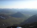
Landscape between Abisko National Park and كبنكايسه


السويد
There are 12 peaks in Sweden that reach above 2،000 m high (6،600 ft), or 13 depending on how the peaks are defined. Eight of them are located in Sarek National Park and the neighbouring national park Stora Sjöfallet. The other four peaks are located in the further north region of Kebnekaise. All mountain names are in Sami but with the more common Swedish spelling of it.
- 2،104 m (6،903 ft) Kebnekaise (Lappland) – Note: Altitude includes the peak glacier. If melting continues, Kebnekaise Nordtoppen, just 500 meters away, might become the highest point.
- 2،097 m (6،880 ft) Kebnekaise Nordtoppen (Lappland) – the highest fixed point in Sweden.
- 2،089 m (6،854 ft) Sarektjåkkå Stortoppen (Lappland)
- 2،076 m (6،811 ft) Kaskasatjåkka (Lappland)
- 2،056 m (6،745 ft) Sarektjåkkå Nordtoppen (Lappland)
- 2،043 m (6،703 ft) Kaskasapakte (Lappland)
- 2،023 m (6،637 ft) Sarektjåkkå Sydtoppen (Lappland)
- 2،016 m (6،614 ft) Akka Stortoppen (Lappland)
- 2،010 m (6،594 ft) Akka Nordvästtoppen (Lappland)
- 2،010 m (6،594 ft) Sarektjåkkå Buchttoppen (Lappland)
- 2،005 m (6،578 ft) Pårtetjåkka (Lappland)
- 2،002 m (6،568 ft) Palkatjåkka (Lappland)
Other popular mountains for skiers, climbers and hikers in Sweden
- Sulitelma 1,860 m (Lappland)
- Helagsfjället 1,796 m (Härjedalen)
- Norra Storfjället 1,767 m (Lappland)
- Templet 1,728 m (Jämtland)
- Lillsylen 1,704 m (Jämtland)
- Åreskutan 1,420 m (Jämtland)
- Storvätteshågna 1,204 m (Dalarna)
- Nipfjället 1,191 m (Dalarna)
- Städjan 1,131 m (Dalarna)
فنلندا

- 1,324 m (4,344 ft) Halti (Lappi/Lapland and Norwegian Troms)
- 1,317 m (4,321 ft) Ridnitsohkka (Lappi/Lapland)
- 1,280 m (4,200 ft) Kiedditsohkka (Lappi/Lapland)
- 1,240 m (4,068 ft) Kovddoskaisi (Lappi/Lapland)
- 1,239 m (4,065 ft) Ruvdnaoaivi (Lappi/Lapland)
- 1,180 m (3,871 ft) Loassonibba (Lappi/Lapland)
- 1,150 m (3,773 ft) Urtasvaara (Lappi/Lapland)
- 1,144 m (3,753 ft) Kahperusvaarat (Lappi/Lapland)
- 1,130 m (3,707 ft) Aldorassa (Lappi/Lapland)
- 1,100 m (3,608 ft) Kieddoaivi (Lappi/Lapland)
انظر أيضاً
الهامش
- ^ "Galdhøpiggen". Nationalencyklopedin (in السويدية). Retrieved 18 July 2010.
- ^ أ ب Lindström, Maurits. "fjällkedjan". Nationalencyklopedin (in السويدية). Retrieved 18 July 2010. خطأ استشهاد: وسم
<ref>غير صالح؛ الاسم "ne1" معرف أكثر من مرة بمحتويات مختلفة. خطأ استشهاد: وسم<ref>غير صالح؛ الاسم "ne1" معرف أكثر من مرة بمحتويات مختلفة. - ^ King, Lorenz (1986). "Zonation and ecology of high mountain permafrost in Scandinavia". Geografiska Annaler (in الإنجليزية). 68A (3): 131–139. doi:10.1080/04353676.1986.11880166.
- ^ Lundqvist, Jan; Lundqvist, Thomas; Lindström, Maurits; Calner, Mikael; Sivhed, Ulf (2011). "Fjällen". Sveriges Geologi: Från urtid till nutid (in السويدية) (3rd ed.). Spain: Studentlitteratur. pp. 323–340. ISBN 978-91-44-05847-4.
- Pages using gadget WikiMiniAtlas
- CS1 السويدية-language sources (sv)
- Short description is different from Wikidata
- Articles containing سويدية-language text
- Coordinates on Wikidata
- Pages using infobox mountain with unknown parameters
- Portal-inline template with redlinked portals
- Pages with empty portal template
- Articles with hatnote templates targeting a nonexistent page
- Pages using Lang-xx templates
- سلاسل جبال أوروپا
- سلاسل جبال النرويج
- جبال فنلندا
- جبال النرويج
- جبال السويد
- اسكندناڤيا