ألوَر
ألوَر | |
|---|---|
Urban | |
 مدينة ألوَر من خزان سـَگـَر | |
| الكنية: بوابة النمر إلى راجستان | |
 ألوَر | |
| Coordinates: 27°32′59″N 76°38′08″E / 27.549780°N 76.635539°E | |
| Country | الهند |
| الولاية | راجستان |
| الضلع | ألوَر |
| Established | 1106 |
| Founded by | Vikram samvat |
| Government | |
| • Body | Municipal Council |
| Area | |
• Urban | 8٬380 كم² (3٬240 ميل²) |
| Elevation | 268 m (879 ft) |
| Population (2018) | |
• Urban | 461٬618 |
| • Rank | الثامنة في راجستان |
| • Density | 55/km2 (140/sq mi) |
| • Metro | 341٬422 |
| اللغات | |
| • الرسمية | هندي |
| • Regional | راجستاني |
| Time zone | UTC+5:30 (IST) |
| PIN | 301001 |
| ISO 3166 code | RJ-IN |
| Vehicle registration | RJ-02 |
| Website | http://alwar.rajasthan.gov.in/ |
ألوَر Alwar تقع على بعد 150 كم جنوب دلهي و 150 كم شمال جايپور، هي مدينة في منطقة العاصمة الوطنية في الهند والمقر الاداري لـضلع ألوَر في ولاية راجستان. Alwar is a hub of tourism with several forts, lakes, heritage havelis and nature reserves, including the Bhangarh Fort, the Sariska Tiger Reserve and Siliserh lake.
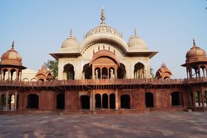
المعالم السياحية
Moosi Maharani ki Chhatri
This cenotaph was built by Vinay Singh in the memory of King Bakhtawar Singh and his queen, Moosi, in 1815.
Ashoka's Buddhist stupa
Nearby Viratnagar there is a Buddhist stupa and an inscription from the Mauryan emperor Ashoka. According to legends, Pandavas spent some time in their ignorance[مطلوب توضيح] here. There are a large number of religious devotees on the Pandupole-Bharthari Loktirtha. Alwar contains a number of historical monuments, such as 'Deewan ji ki lal haweli', which was built in 1754 and owned by Rajendra Kumar Jain.
Hill Fort Kesroli
Hill Fort Kesroli, a 14th-century fort, has now been converted into and is conserved as a heritage hotel.[1]
Bharthari Temple
Bharthari temple is dedicated to the king of Ujjain, who became a saint and is now commonly known as Baba Bharthari. He is sometimes identified with Bhartṛhari, a 7th-century poet. He is revered and prayed to, the temple is visited by the local population, and a fair is also organized each year known as 'Bharthari Baba ka Mela'.there is a temple of hanuman baba in ghata bhanwar tehsil kathumar
-
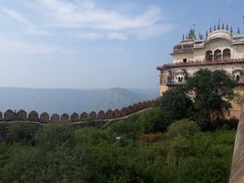 Alwar fort or Bala Quila
 -
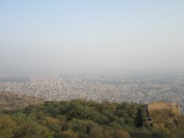 Alwar city top view from Bala Quila
 -
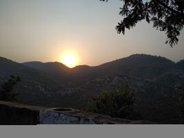 Sunset from the top of Alwar fort/Bala Quila.
 -
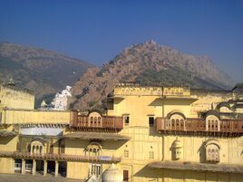 Museum near Alwar fort with Aravali hill in background
 -
 Cenotaph of Musi Maharani


السكان
| Population Growth of Alwar City | |||
|---|---|---|---|
| Census | Pop. | %± | |
| 1891 | 52٬400 | ||
| 1901 | 56٬700 | 8.2% | |
| 1911 | 41٬300 | -27.2% | |
| 1921 | 44٬800 | 8.5% | |
| 1941 | 54٬100 | ||
| 1951 | 57٬900 | 7.0% | |
| 1961 | 72٬700 | 25.6% | |
| 1971 | 100٬800 | 38.7% | |
| 1981 | 140٬000 | 38.9% | |
| 1991 | 210٬100 | 50.1% | |
| 2001 | 266٬203 | 26.7% | |
| 2011 | 341٬422 | 28.3% | |
| source:[2] | |||
At the time of the 2011 census, the population of Alwar city and Alwar district were 341,422 and 3,674,179 respectively, with Hindus representing 90.7% of the population, Muslims representing 4.3%, Sikhs representing 2.6%, Jains representing 2.1%, and the remaining 1.3% belonging to other religions.[3][4]
المراجع
- ^ "Ruins revisited". The Hindu. July 29, 2004.
- ^ "Historical Census of India". Populstat.info. Archived from the original on 17 فبراير 2013. Retrieved 19 نوفمبر 2014.
- ^ "Alwar District Population Census 2011, Rajasthan literacy sex ratio and density". census2011.co.in. Archived from the original on 16 فبراير 2013. Retrieved 6 أبريل 2013.
- ^ "Archived copy". Archived from the original on 4 نوفمبر 2016. Retrieved 30 يوليو 2016.
{{cite web}}: CS1 maint: archived copy as title (link) Alwar City Population Census 2011
Bibliography
- Powlett, P. W. (1838). Gazetteer of Ulwur (Alwar). Retrieved 19 November 2014.
وصلات خارجية
| موضوعات |  | ||||||||||||||
|---|---|---|---|---|---|---|---|---|---|---|---|---|---|---|---|
| الحكم | |||||||||||||||
| الأقسام و الأضلاع |
| ||||||||||||||
| المدن الرئيسية | |||||||||||||||
| قوالب متعلقة | |||||||||||||||
| International | |
|---|---|
| National | |
- Pages using gadget WikiMiniAtlas
- Short description is different from Wikidata
- Coordinates on Wikidata
- Pages using infobox settlement with unknown parameters
- جميع الصفحات التي تحتاج تنظيف
- مقالات بالمعرفة تحتاج توضيح from November 2017
- Articles with hatnote templates targeting a nonexistent page
- Official website different in Wikidata and Wikipedia
- ألوَر
- Cities and towns in Alwar district