محافظة أضنة
محافظة أضنة
Adana İli (تركية) | |
|---|---|
 موقع محافظة أضنة في تركيا. | |
| البلد | تركيا |
| المنطقة | البحر المتوسط |
| المنطقة الفرعية | أضنة |
| الحكومة | |
| • الدائرة الانتخابية | أضنة |
| • المحافظ | سليمان إلبان |
| المساحة | |
| • الإجمالي | 14٫030 كم² (5٫417 ميل²) |
| التعداد (2018) | |
| • الإجمالي | 2٬220٬125 |
| • الكثافة | 160٬000/km2 (410٬000/sq mi) |
| مفتاح الهاتف | 0322 |
| لوحة السيارة | 01 |
| الموقع الإلكتروني | http://adana.gov.tr/ |
محافظة أضنة Adana Province (تركية: Adana ili)، هي إحدى محافظات تركيا وتقع في جنوب وسط الأناضول. وهي خامس أكثر محافظات تركيا إكتظاظاً، إذ يبلغ تعداد سكانها 2.085.225 نسمة. عاصمتها مدينة أضنة، ويقيم بها 78% من إجمالي سكان المحافظة.
الجغرافيا
The southern and central portion of the province mostly falls within the Çukurova Plain (historically known as the Cilician Plain), to the north, the plains give way to the Taurus Mountains (Turkish: Toros Dağları). The provinces adjacent to it are Mersin to the west, Hatay to the southeast, Osmaniye to the east, Kahramanmaraş to the northeast, Kayseri to the north, and Niğde to the northwest.[بحاجة لمصدر]
الحكومة
Two levels of government are involved in the administration of the Adana Province: the Central and the Provincial. Adana Governorship is the provincial branch of the Central government and Adana Province Special Administration is the provincial governing body. The province is divided into 15 districts and each district is divided into municipalities and villages. Municipalities are further divided into neighborhoods (تركية: Mahalle).[بحاجة لمصدر]
برلمان المحافظة
| District | MPs |
|---|---|
| Seyhan | 11 |
| Yüreğir | 8 |
| Çukurova | 7 |
| Sarıçam | 5 |
| Karaisalı | 2 |
| Aladağ | 2 |
| Ceyhan | 6 |
| Feke | 2 |
| İmamoğlu | 3 |
| Karataş | 2 |
| Kozan | 5 |
| Pozantı | 2 |
| Saimbeyli | 2 |
| Tufanbeyli | 2 |
| Yumurtalik | 2 |
| Total | 61 |
التمثيل الحزبي الحالي=
| Party | Votes | Seats | ||
|---|---|---|---|---|
| No | % | No | % | |
| AK Party | 324,968 | 29.8 | 27 | 44.3 |
| MHP | 296,338 | 27.17 | 23 | 37.7 |
| CHP | 252,073 | 23.11 | 9 | 14.75 |
| DTP | 86,775 | 7.96 | 1 | 1.64 |
| DP | 34,543 | 3.167 | 1 | 1.64 |
| Other | 95,989 | 8.8 | 0 | 0 |
| Province | 1,090,686 | 61 | ||
البلديات
الضواحي
القرى
السكان

| District | Urban | Rural | Total |
|---|---|---|---|
| Seyhan | 723,277 | 0 | 723,277 |
| Yüreğir | 417,693 | 4,836 | 422,529 |
| Çukurova | 343,770 | 4,171 | 347,941 |
| Sarıçam | 99,313 | 21,012 | 120,325 |
| Karaisalı | 7,465 | 15,516 | 22,981 |
| Aladağ | 4,139 | 13.030 | 17,169 |
| Ceyhan | 105,879 | 52,850 | 158,729 |
| Feke | 4,603 | 14,393 | 18,996 |
| İmamoğlu | 20,593 | 9.959 | 30,552 |
| Karataş | 8.483 | 12,777 | 21,260 |
| Kozan | 76,864 | 50,236 | 127,100 |
| Pozantı | 9,864 | 10,415 | 20,279 |
| Saimbeyli | 3,984 | 13,371 | 17,355 |
| Tufanbeyli | 5,376 | 12,696 | 18,072 |
| Yumurtalik | 5,129 | 13,531 | 18,660 |
| Province | 1,836,432 | 248,793 | 2,085,225 |
المتاحف ومواقع التراث
Adana Province has 160 km. of coastline mostly free from human activities. Karataş and Yumurtalık are the two small settlements at the coast which host cottage dwellers and local tourism. Rest of the coast has conservation areas, farmlands and forests. With the ancient settlements, national parks, waterfalls, highlands and mountains, Adana Province has a mixture of different settings.[بحاجة لمصدر]
المتاحف
المواقع التاريخية


- Toprakkale (Misis)
- Dumlu Castle (Ceyhan)
- Historical neighborhood of Tepebağ (Adana)
- Ramazanoğlu Hall (Adana)
- Kurtkulağı Caravanserai in Ceyhan
- Hayriye Hanım Hall in Reşatbey neighborhood of Adana
- Çarşı Hamam (Adana)
- Büyük Saat Clock Tower and the Bedesten (bazaar) in the city of Adana
- Taşköprü: 4th century Roman Bridge in the city of Adana
- Kozan Castle and Manastir
- Ulucamii in the city of Adana
- Hasan Ağa Masjid (Adana)
- Yağ Camii in the city of Adana
- Saint Paul Church (Bebekli Kilise) in the city of Adana
المستوطنات القديمة
| المستوطنات القديمة في محافظة أضنة | |||
|---|---|---|---|
| الاسم | الفترة | البعد عن مدينة أضنة | المقاطعة |
| Şar (Comona) | Hitite-Roman-Armenian | 211 كم. | Tufanbeyli |
| Ayas | Greek-Roman | 78 كم. | Yumurtalık |
| Mallos | Greek-Roman | 50 كم. | Karataş |
| Misis | Hitite-Roman-Arabic-Ottoman | 27 كم. | Misis, Yakapınar |
| Magarsos | Greek-Roman | 50 كم. | Karataş |
| Tumlu | Middle Age | 50 كم. | Ceyhan |
| Mazırık | Early Age | 50 كم. | Karaisalı |
| Anavarza | Ceyhan | ||
| Akören | Aladağ | ||
| Sirkeli Tumulus |
المنتزهات والمحميات
الجبال والهضاب

المهرجانات
انظر أيضاً
معرض الصور
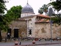
Seyhan, Historical Mosque, Ulucami
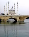
Seyhan, Historical Roman Bridge and Sabanci Mosque,
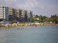
Yumurtalık Beach
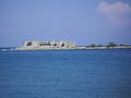
Deniz (Kız) Castle in Yumurtalık


_Beach.jpg&filetimestamp=20130713234533&)
_Castle.jpg&filetimestamp=20130713234539&)
المصادر
وصلات خارجية
| المقاطعات الحضرية |  | |
|---|---|---|
| المقاطعات الريفية | Aladağ - جيحان - Feke - إماماوغلو - قرة طاش - كوزان - پوزانتي - صايمبايلي - طوفانبايلي - يمرطالق | |
المناطق | ||
| إيجه | ||
| البحر الأسود | ||
| وسط الأناضول | ||
| شرق الأناضول | ||
| مرمرة | ||
| البحر المتوسط | ||
| جنوب شرق الأناضول | ||