زالدبومل
Zaltbommel
Bommel | |
|---|---|
Saint Martin church City hall Gasthuis Tower Market Maarten van Rossum museum Water gate | |
 Flag  Coat of arms | |
 Zaltbommel Location within the Netherlands  Zaltbommel Location within Europe | |
| Coordinates: 51°48′N 5°15′E / 51.800°N 5.250°E | |
| Country | Netherlands |
| Province | Gelderland |
| Government | |
| • Body | Municipal council |
| • Mayor | Peter Rehwinkel (acting) (PvdA) |
| Area | |
• Total | 89٫04 كم² (34٫38 ميل²) |
| • Land | 79٫61 كم² (30٫74 ميل²) |
| • Water | 9٫43 كم² (3٫64 ميل²) |
| Elevation | 3 m (10 ft) |
| Population (أغسطس 2017)[4] | |
• Total | 27٬940 |
| • Density | 351/km2 (910/sq mi) |
| Time zone | UTC+1 (CET) |
| • Summer (DST) | UTC+2 (CEST) |
| Postcode | 5300–5311, 5315–5318 |
| Area code | 0418 |
| Website | www |


Zaltbommel (النطق الهولندي: [zɑldˈbɔməl] (![]() استمع)), also known, historically and colloquially, as Bommel, is a municipality and a city in the Netherlands.
استمع)), also known, historically and colloquially, as Bommel, is a municipality and a city in the Netherlands.
History
The city of Zaltbommel
The town of Zaltbommel was first mentioned as "Bomela" in the year 850. Zaltbommel received city rights in 1231 and these were renewed in 1316. In 1599 during the Eighty Years War, Zaltbommel was besieged by Spanish forces but was relieved by an Anglo-Dutch force led by Maurice of Orange. The bridge over the Waal at Zaltbommel (which has since been replaced) features in a celebrated twentieth-century Dutch sonnet, De moeder de vrouw, by Martinus Nijhoff.[5]
Zaltbommel was expanded to its current size on 1 January 1999, by a merger of the municipalities of Brakel, Kerkwijk and Zaltbommel. The municipality is situated in the heart of the Netherlands, close to the A2 Motorway, the railway line from Utrecht to 's‑Hertogenbosch and the rivers Waal and Maas.
Topography

Dutch Topographic map of Zaltbommel (municipality), Sept. 2014
Population centres
The municipality, consists of 13 population centres and had a population of 27٬940 in 2017.
| Name | Population (1-1-2015) |
Population (1-1-2016) |
|---|---|---|
| Aalst | 2102 | 2106 |
| Bern | 36 | 33 |
| Brakel | 3050 | 3066 |
| Bruchem | 1674 | 1668 |
| Delwijnen | 341 | 337 |
| Gameren | 2433 | 2466 |
| Kerkwijk | 629 | 640 |
| Nederhemert | 1612 | 1604 |
| Nieuwaal | 732 | 758 |
| Poederoijen | 1013 | 1039 |
| Zaltbommel | 12040 | 12143 |
| Zuilichem | 1704 | 1702 |
| Total | 27366 | 27562 |
Notable residents


- Maarten van Rossum (ca.1478–1555) military tactician and commander
- Elbertus Leoninus (1519 or 1520 – 1598) jurist and statesman, helped negotiate the Pacification of Ghent
- Marigje Arriens (ca.1520–1591) an alleged Dutch witch
- Caspar Barlaeus (1584–1648) polymath and Renaissance humanist, a theologian, poet, and historian
- Andreas Essenius (1618–1677) Dutch Reformed theologian, controversialist and academic
- Jacob Abraham de Mist (1749–1823) statesman, Head of State of the National Assembly of the Batavian Republic
- Lion Philips (1794–1866) tobacco merchant, grandfather of Gerard and Anton Philips
- Sophie Pressburg (1797–1854), grandmother of Anton and Gerard Philips
- Hendrik Antonie Lodewijk Hamelberg (1826–1896), consul general and special envoy of the Orange Free State
- Gerard Philips (1858–1942), industrialist, co-founder of Philips Electronics
- Anton Philips (1874–1951), industrialist, co-founder of Philips Electronics
- Johannes van Maaren (1890–1963) wrestler, competed at the 1920, 1924 and 1928 Summer Olympics
- Anouchka van Miltenburg (born 1967) retired politician
The arts

- Lucas Vorsterman (1595–1675), Baroque engraver
- Warnard van Rijsen (1625–1670), a Dutch Golden Age painter.
- Johannes Vorstermans (ca.1643– ca.1699/1719) Dutch Golden Age landscape painter.
- Gerard Hoet, (1648–1743) Dutch Golden Age painter
- Jan Soukens (c.1650–c.1725) a Dutch Golden Age painter
- Suzanne Leenhoff (1829–1906), pianist, married Édouard Manet at Zaltbommel in 1863[6]
- Peter van Anrooy (1879–1954) composer and conductor of classical music
- Fiep Westendorp (1916-2004), illustrator
- Thorwald Jørgensen (born 1980) classical musician, specialises in the theremin
Image gallery
-
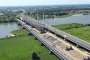 Zaltbommel (in the upper right-hand corner of the image) is situated on the banks of the Waal. Major north–south highways and railways cross the river in the town, just east of the town centre.
 -
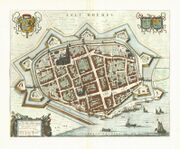 1649 map of Zaltbommel in Willem and Joan Blaeu's "Toonneel der Steden"
 -
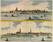 Tyel & Salt Boemel, 1649


References
- ^ "Burgemeester Van den Bosch" [Mayor Van den Bosch] (in الهولندية). Gemeente Zaltbommel. Retrieved 24 July 2014.
- ^ "Kerncijfers wijken en buurten" [Key figures for neighbourhoods]. CBS Statline (in Dutch). CBS. 2 July 2013. Retrieved 12 March 2014.
{{cite web}}: CS1 maint: unrecognized language (link) - ^ "Postcodetool for 5301LB". Actueel Hoogtebestand Nederland (in الهولندية). Het Waterschapshuis. Retrieved 24 July 2014.
- ^ "Bevolkingsontwikkeling; regio per maand" [Population growth; regions per month]. CBS Statline (in Dutch). CBS. 27 October 2017. Retrieved 27 October 2017.
{{cite web}}: CS1 maint: unrecognized language (link) - ^ Hollandse Gedichten http://home.kpn.nl/grumbl/gedichten/Hollandse%20gedichten/Hollandse%20gedichten.htm Retrieved 4 August 2017
- ^ Streekarchief Bommelerwaard (Zaltbommel district archive, in Dutch) Retrieved 5 January 2017
External links
 Media related to زالدبومل at Wikimedia Commons
- Official website (in هولندية)
أماكن قريبة من زالدبومل | |
|---|---|
قالب:Dutch municipality Zaltbommel
| International | |
|---|---|
| National | |
- Pages using gadget WikiMiniAtlas
- CS1 الهولندية-language sources (nl)
- Short description is different from Wikidata
- Pages using multiple image with auto scaled images
- Coordinates on Wikidata
- Official website different in Wikidata and Wikipedia
- Articles with هولندية-language sources (nl)
- Zaltbommel
- Municipalities of Gelderland
- Populated places in Gelderland