أوبلاست ڤولوگدا
أوبلاست ڤولوگدا | |
|---|---|
| Вологодская область | |
 Flag  Coat of arms | |
| النشيد: [1] | |
 | |
| Coordinates: 60°05′N 40°27′E / 60.083°N 40.450°E | |
| البلد | روسيا |
| المنطقة الاتحادية | الشمالية الغربية[2] |
| المنطقة الاقتصادية | الشمالية[3] |
| تأسست | September 23, 1937[4] |
| المركز الاداري | ڤولوگدا[5] |
| Government | |
| • Body | Legislative Assembly of Vologda Oblast[6] |
| • Governor of Vologda Oblast[6] | Oleg Kuvshinnikov[7] |
| Area | |
• Total | 145٬700 كم² (56٬300 ميل²) |
| • Rank | 25th |
| Population (2010 Census)[9] | |
• Total | 1٬202٬444 |
• Estimate (2018) | 1٬176٬689 (−2٫1%) |
| • Rank | 42nd |
| • Density | 8٫3/km2 (21/sq mi) |
| • Urban | 70٫7% |
| • Rural | 29٫3% |
| Time zone | UTC+3 (توقيت موسكو |
| ISO 3166 code | RU-VLG |
| لوحات السيارات | 35 |
| OKTMO ID | 19000000 |
| اللغات الرسمية | الروسية[11] |
| Website | http://www.vologda-oblast.ru/ |
أوبلاست ڤولوگدا (روسية: Вологодская область, النطق Vologodskaya oblast; النطق الروسي: [vəlɐˈɡotskəjə ˈobləsʲtʲ]؛ إنگليزية: Vologda Oblast) هي إحدى الكيانات الفدرالية في روسيا.
التاريخ

الجغرافيا


Vologda Oblast borders with Arkhangelsk Oblast in the north, Kirov Oblast in the east, Kostroma Oblast in the southeast, Yaroslavl Oblast in the south, Tver and Novgorod Oblasts in the southwest, Leningrad Oblast in the west, and the Republic of Karelia in the northwest.
Vologda Oblast is located on the East European Plain, and most of it represents forested hilly landscape. The southwest of the oblast, along the Sheksna and the Mologa, is flat. The northwestern part is mostly of glacial origin, with the Andoma Hills, the Veps Hills, and a number of minor hill chains.[12] In the east of the oblast, the valleys of the Vaga, the Sukhona, and the Yug are cut through the hills. The southeast of the oblast is occupied by the Northern Ridge, which is located south of the valley of the Sukhona.
Much of the area of the oblast is occupied by coniferous forest (taiga) and by swamps.
التقسيمات الادارية
أوبلاست ڤولوگدا يحوي المدن والقرى التالية:
كادنيكوف، خاروفسك، كيريلوف، كراسافينو، نيكولسك،
الديمغرافيا
Population: 1,202,444 (تعداد 2010);[9] 1,269,568 (تعداد 2002);[13] 1,353,870 (تعداد 1989).[14]
Ethnic composition (2010):[9]
- Russians - 97.3%
- Ukrainians - 0.7%
- Belarusians - 0.3%
- Veps - 0.04
- Others - 1.7%
- 58,511 people were registered from administrative databases, and could not declare an ethnicity. It is estimated that the proportion of ethnicities in this group is the same as that of the declared group.[15]
- Vital statistics for 2012
2009 - 1.61 | 2010 - 1.60 | 2011 - 1.68 | 2012 - 1.84 | 2013 - 1.85 | 2014 - 1.86 | 2015 - 1.92 | 2016 - 1.90(e)
Babayevsky and Vytegorsky District in the northwest of the oblast belong to the areas traditionally populated by Vepsians. The Vepsians living in Vologda Oblast speak the central group of Veps dialects.[18]
الدين
الاقتصاد
الصناعة
الزراعة

النقل

The oil transport system, Baltic Pipeline System, runs through the oblast, with three oil-pumping stations located at Nyuksenitsa, Pogorelovo, and Gryazovets.
الفنون والثقافة
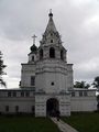
العمارة

معرض صور
-
-
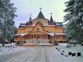 The residence of Ded Moroz في Veliky Ustyug
 -
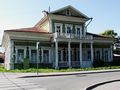 Zasetsky House في ڤولوگدا (the 1790s)


الأدب

المراجع
الهامش
- ^ Article 2 of the Charter of Vologda Oblast does not specify any symbols of the oblast other than a flag and a coat of arms
- ^ Президент Российской Федерации. Указ №849 от 13 мая 2000 г. «О полномочном представителе Президента Российской Федерации в федеральном округе». (President of the Russian Federation. Decree #849 of May 13, 2000 On the Plenipotentiary Representative of the President of the Russian Federation in a Federal District).
- ^ Госстандарт Российской Федерации. №ОК 024-95 27 декабря 1995 г. «Общероссийский классификатор экономических регионов. 2. Экономические районы», в ред. Изменения №5/2001 ОКЭР. (گوستاندارت of the Russian Federation. #OK 024-95 December 27, 1995 Russian Classification of Economic Regions. 2. Economic Regions, as amended by the Amendment #5/2001 OKER).
- ^ Resolution of September 23, 1937
- ^ Charter of Vologda Oblast, Article 11
- ^ أ ب Charter of Vologda Oblast, Article 12
- ^ Official website of Vologda Oblast. Oleg Alexandrovich Kuvshinnikov, Governor of Vologda Oblast (in روسية)
- ^ Федеральная служба государственной статистики (Federal State Statistics Service) (2004-05-21). "Территория, число районов, населённых пунктов и сельских администраций по субъектам Российской Федерации (Territory, Number of Districts, Inhabited Localities, and Rural Administration by Federal Subjects of the Russian Federation)". Всероссийская перепись населения 2002 года (All-Russia Population Census of 2002) (in الروسية). Federal State Statistics Service. Retrieved 2011-11-01.
- ^ أ ب ت Russian Federal State Statistics Service (2011). "Всероссийская перепись населения 2010 года. Том 1". Всероссийская перепись населения 2010 года (2010 All-Russia Population Census) (in Russian). Federal State Statistics Service. Retrieved June 29, 2012.
{{cite web}}: Invalid|ref=harv(help); Unknown parameter|trans_title=ignored (|trans-title=suggested) (help)CS1 maint: unrecognized language (link) - ^ "Об исчислении времени". Официальный интернет-портал правовой информации (in الروسية). 3 June 2011. Retrieved 19 January 2019.
- ^ الرسمية في جميع أرجاء روسيا الاتحادية حسب الفقرة 68.1 من دستور روسيا.
- ^ Вологодская область. Great Soviet Encyclopedia.
- ^ Федеральная служба государственной статистики (Federal State Statistics Service) (2004-05-21). "Численность населения России, субъектов Российской Федерации в составе федеральных округов, районов, городских поселений, сельских населённых пунктов – районных центров и сельских населённых пунктов с населением 3 тысячи и более человек[[Category:Articles containing روسية-language text]] (Population of Russia, its federal districts, federal subjects, districts, urban localities, rural localities—administrative centers, and rural localities with population of over 3,000)". Всероссийская перепись населения 2002 года (All-Russia Population Census of 2002) (in Russian). Federal State Statistics Service. Retrieved 2008-07-25.
{{cite web}}: URL–wikilink conflict (help)CS1 maint: unrecognized language (link) - ^ "Всесоюзная перепись населения 1989 г. Численность наличного населения союзных и автономных республик, автономных областей и округов, краёв, областей, районов, городских поселений и сёл-райцентров.[[Category:Articles containing روسية-language text]] (All Union Population Census of 1989. Present population of union and autonomous republics, autonomous oblasts and okrugs, krais, oblasts, districts, urban settlements, and villages serving as district administrative centers.)". Всесоюзная перепись населения 1989 года (All-Union Population Census of 1989) (in Russian). Demoscope Weekly (website of the Institute of Demographics of the State University—Higher School of Economics. 1989. Retrieved 2007-12-13.
{{cite web}}: Italic or bold markup not allowed in:|publisher=(help); URL–wikilink conflict (help)CS1 maint: unrecognized language (link) - ^ "Перепись-2010: русских становится больше". Perepis-2010.ru. 2011-12-19. Retrieved 2013-05-08.
- ^ "Естественное движение населения в разрезе субъектов Российской Федерации". Gks.ru. Retrieved 2013-05-08.
- ^ "Каталог публикаций::Федеральная служба государственной статистики". www.gks.ru. Retrieved March 17, 2018.
- ^ Hermann, Luc (April 15, 2011). "L'extinction d'un peuple finno-ougrien: les Vepses". Regard sur l'Est (in French).
{{cite journal}}: CS1 maint: unrecognized language (link) - ^ "Arena: Atlas of Religions and Nationalities in Russia". Sreda, 2012.
- ^ 2012 Arena Atlas Religion Maps. "Ogonek", № 34 (5243), 27/08/2012. Retrieved 21/04/2017. Archived.
المصادر
- قالب:RussiaBasicLawRef/vlg
- Центральный исполнительный комитет СССР. Постановление от 23 сентября 1937 г. «О разделении Северной области на Вологодскую и Архангельскую области». (Central Executive Committee of the USSR. Resolution of September 23, 1937 On Splitting Northern Oblast into Vologda and Arkhangelsk Oblasts).
ببليوگرافيا
- Brumfield, William. Vologda Album (Moscow: Tri Kvadrata, 2005) ISBN 5-94607-050-9
وصلات خارجية
- Pages using gadget WikiMiniAtlas
- Articles containing روسية-language text
- Articles with روسية-language sources (ru)
- CS1 الروسية-language sources (ru)
- CS1 errors: unsupported parameter
- CS1 errors: URL–wikilink conflict
- CS1 errors: markup
- Short description is different from Wikidata
- Coordinates on Wikidata
- Articles containing إنگليزية-language text
- Pages using Lang-xx templates
- أوبلاست ڤولوگدا
- دول وأقاليم تأسست في 1937
- اوبلاستات روسيا