صرميا


صرميا (بالصربية: [Срем, Srem] Error: {{Lang}}: text has italic markup (help); كرواتية: Srijem؛ إنگليزية: Syrmia) هي منطقة خصبة في السهل الپانوني في أوروپا، بين نهري الدانوب وساڤا. وتتقاسمها صربيا في الشرق وكرواتيا في الغرب.
Most of Syrmia is located in the Srem and South Bačka districts of Serbia's Autonomous Province of ڤويڤودينا. A smaller part of the region around Novi Beograd, Zemun, and Surčin belongs to the City of Belgrade. The westernmost part is in eastern Croatia in Vukovar-Srijem.
الاسم
اليوم، الاسم Srijem is used in the standard Croatian language to designate the region, whereas both Srem (Cyrillic: Срем) و Srijem (بالسيريلية: Сријем) are used in the two standard varieties of Serbian. Other names for the region include:
- اللاتينية: Syrmia أو Sirmium
- بالألمانية: Syrmien
- بالمجرية: Szerémség or Szerém
- بالسلوڤاكية: Sriem
- بالروسين: Срим
- بالتركية: Sirem
- بالأوكرانية: Срем, also Срім or Срим
- بالفرنسية: Syrmie
- بالإيطالية: Sirmia
- باليونانية: Syrmia, Σύρμια
التاريخ

كانت صرميا جزءاً من الامبراطورية الرومانية، امبراطورية الهون، مملكة القوط الشرقيين، مملكة الگپد، دولة اللومبارد، الامبراطورية البيزنطية، خاقانية الآڤار، امبراطورية الفرنجة، الامبراطورية البلغارية، كرواتيا الپانونية، مملكة المجر، الدولة العثمانية، ملكية هابسبورگ، الامبراطورية النمساوية، النمسا-المجر، دولة السلوڤين، الكروات والصرب، مملكة صربيا، مملكة الصرب، الكروات والسلوڤين، مملكة يوغسلاڤيا، وجمهورية يوغسلاڤيا الاتحادية الاشتراكية which, upon advice from the Ðilas Commission, assigned the eastern part of the region to the Federated Republic of Serbia and the western part to the Federated Republic of Croatia in 1945. الجزء في أقصى غرب صرميا يقع في شرق كرواتيا في Vukovar-Srijem، بينما أغلبية صرميا هي جزء من جمهورية صربيا.[citation needed]
Between 3000 BC and 2400 BC, Syrmia was a core area of Indo-European Vučedol culture.[1]
The name Syrmia derives from the name of the ancient city of Sirmium, today Sremska Mitrovica. Sirmium was originally an Celtic or Illyrian town founded in 3rd century BC and conquered by Romans in the 1st century BC. Opposing Roman rule, Illyrian tribes from the region started an uprising in AD 6 lead by Baton and Pines. Sirmium was an important city in the Roman Empire. It was the economic capital of Roman Pannonia and one of four capital cities of the Empire. Ten Roman Emperors were born in this city or in its surroundings: Herennius Etruscus (227-251), Hostilian (230?-251), Decius Traian (249-251), Claudius II (268-270), Quintillus (270), Aurelian (270-275), Probus (276-282), Maximianus Herculius (285-310), Constantius II (337-361) and Gratian (367-383). These emperors were mostly Romanised Illyrians by origin. The Roman province Pannonia Secunda, which included Syrmia and parts of present day Slavonia and Bosnia was administered from Sirmium.
The name Syrmia derives from the name of the ancient city of Sirmium, today Sremska Mitrovica. Sirmium was originally an Celtic or Illyrian town founded in 3rd century BC and conquered by Romans in the 1st century BC. Opposing Roman rule, Illyrian tribes from the region started an uprising in AD 6 lead by Baton and Pines. Sirmium was an important city in the Roman Empire. It was the economic capital of Roman Pannonia and one of four capital cities of the Empire. Ten Roman Emperors were born in this city or in its surroundings: Herennius Etruscus (227-251), Hostilian (230?-251), Decius Traian (249-251), Claudius II (268-270), Quintillus (270), Aurelian (270-275), Probus (276-282), Maximianus Herculius (285-310), Constantius II (337-361) and Gratian (367-383). These emperors were mostly Romanised Illyrians by origin. The Roman province Pannonia Secunda, which included Syrmia and parts of present day Slavonia and Bosnia was administered from Sirmium.
-
 Ancient Indo-European peoples in Syrmia
 -
 Ancient Roman cities in Syrmia
 -
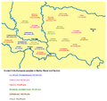
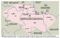
 Territory ruled by Sermon, a duke of Syrmia, 11th century
 -
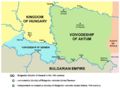
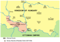
 Realms of Stefan Dragutin and Ugrin Csák, 14th century
 -
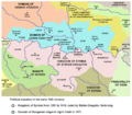
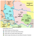
 Realm of Stefan Dragutin, 13th-14th century, according to the book of historian Stanoje Stanojević


-
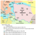
 Duchy of Syrmia of Radoslav Čelnik in 1527-1530
 -
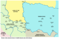
 Ottoman Sanjak of Syrmia in 1568-1571
 -
 Habsburg-Ottoman frontier in Syrmia in 1699


On 29 October 1918, Syrmia became a part of the newly independent State of Slovenes, Croats and Serbs, while on 24 November, the Assembly of Syrmia proclaimed the unification of Serb-populated parts of Syrmia with the Kingdom of Serbia. From 1 December 1918, all of Syrmia was part of the Kingdom of Serbs, Croats and Slovenes.
-
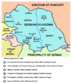 Proclaimed borders of the Serbian Voivodship in 1848, including most of Syrmia.
 -
 The County of Syrmia within Croatia-Slavonia in 1881.
 -
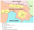 Liberated partisan territory in Syrmia in the end of 1942
 -
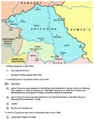 Syrmian frontline before April 1945


الديمغرافيا

According to the 2001 census in Croatia, the population of the Croatian Vukovar-Srijem county, numbering 204,768, is composed of:[2]
- 160,277 Croats (78.27%)
- 31,644 Serbs (15.45%)
- 2,047 Hungarians (1%)
- 1,796 Rusyns (0.88%)
- 1,338 Slovaks (0.65%)
الجغرافيا
الحدود


Bordering regions
- Bačka to the north, across Danube
- Banat to the east, also across Danube
- Šumadija the south-east, across Sava
- Mačva to the south, across Sava
- Semberija to the south-west, across Sava
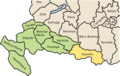
- Slavonia to the west. The border between Syrmia and Slavonia is unclear. According to one interpretation, it runs roughly along a line through Vukovar, Vinkovci, and Županja. According to another interpretation, the border follows the Bosut, Barica and Vuka rivers.
المدن

List of cities in Syrmia (with population figures):
- Serbia
- Belgrade city region
- Novi Beograd (217,180)
- Zemun (146,172)
- Surčin (14,209)
- Dobanovci (8,114)
- Vojvodina
- Sremska Mitrovica (39,041)
- Ruma (32,125)
- Inđija (26,244)
- Stara Pazova (18,628)
- Šid (16,301)
- Petrovaradin (13,917)
- Sremska Kamenica (11,140)
- Sremski Karlovci (8,839)
- Beočin (8,037)
- Irig (4,854)
- Belgrade city region
- Croatia
Petrovaradin, Sremska Kamenica, Sremski Karlovci and Beočin are geographically located in Syrmia, but they are part of South Bačka District.
البلديات
Municipalities in the Serbian part of Syrmia:
- Šid
- Sremska Mitrovica
- Irig
- Ruma
- Inđija
- Stara Pazova
- Pećinci
- Novi Beograd
- Zemun
- Surčin
- Sremski Karlovci
- Petrovaradin
- Beočin
Note: Syrmian villages of Neštin and Vizić are part of the municipality of Bačka Palanka (main part of this municipality is not located in Syrmia but in Bačka), while several settlements that are part of the municipality of Sremska Mitrovica are not located in Syrmia but in Mačva.
Municipalities and villages in the Croatian part of Syrmia:
- Vukovar
- Ilok
- Vinkovci
- Županja
- Otok
- Trpinja[citation needed]
- Borovo[citation needed]
- Tordinci[citation needed]
- Markušica[citation needed]
- Jarmina[citation needed]
- Ivankovo[citation needed]
- Vođinci[citation needed]
- Stari Mikanovci[citation needed]
- Babina Greda[citation needed]
- Cerna
- Gradište
- Andrijaševci
- Privlaka
- Bošnjaci
- Drenovci
- Gunja
- Vrbanja
- Nijemci
- Tovarnik
- Lovas
- Tompojevci
- Stari Jankovci
- Negoslavci
- Bogdanovci
- Nuštar
الجبال
The region's principal mountain is Fruška Gora with its highest peak of Crveni Čot at 539 m.
انظر أيضاً
- Srem District
- Vukovar-Srijem County
- Syrmia County
- Sanjak of Syrmia
- Kingdom of Srem
- Theme of Sirmium
- Sirmium
- ڤويڤودينا
- سلاڤونيا
- Serbian Orthodox Eparchy of Srem
- Roman Catholic Diocese of Srijem
الهامش
- ^ Syrmia, vjesnik.hr; accessed 13 April 2015.
- ^ http://www.dzs.hr/Hrv/Popis%202001/popis20001.htm

| المناطق التاريخية الرئيسية |  | ||||||||
|---|---|---|---|---|---|---|---|---|---|
| المناطق الصغرى |
| ||||||||
- Pages using gadget WikiMiniAtlas
- Articles with hatnote templates targeting a nonexistent page
- Missing redirects
- Articles containing كرواتية-language text
- Pages using Lang-xx templates
- Articles containing إنگليزية-language text
- Articles with unsourced statements from April 2015
- Articles with unsourced statements from June 2012
- Coordinates on Wikidata
- صرميا
- مناطق صربيا
- جغرافيا ڤويڤودينا
- جغرافيا بلگراد
- مناطق كرواتيا
- سلاڤونيا
- مناطق تاريخية في صربيا
- مناطق تاريخية في كرواتيا
- مناطق مقسمة