سلوقية قيليقيا
سيليفكه
Silifke | |
|---|---|
 Göksu river in Silifke | |
 سيليفكه | |
| Coordinates: 36°22′34″N 33°55′56″E / 36.37611°N 33.93222°E | |
| البلد | |
| المحافظة | مرسين |
| Government | |
| • العمدة | مصطفى تورگوت (CHP) |
| • قائمقام | فاتح دماتلار |
| Area | |
| • District | 2٬571٫84 كم² (992٫99 ميل²) |
| Population (2012)[2] | |
| • Urban | 55٬501 |
| • District | 114٬238 |
| • District density | 44/km2 (120/sq mi) |
| Website | www.silifke-bld.gov.tr |
سلوقية أو سيليفكه (Silifke ؛ باليونانية: Σελεύκεια؛ Seleukeia؛ لاتينية: Seleucia ad Calycadnum) هي بلدة وقضاء في جنوب-وسط محافظة مرسين، تركيا، على بعد 80 كم غرب مدينة مرسين، على الطرف الغربي لـ Çukurova.
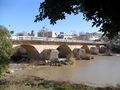
Silifke is near the Mediterranean coast, on the banks of the Göksu River, which flows from the nearby Taurus Mountains, surrounded by attractive countryside along the river banks.
أصل الاسم
كانت سيليفكه تُدعى في السابق سلوقية على الكاليكادنوس — وقد ذُكِرت بأشكال مختلفة على مر القرون، مثل سلوقية [في] قيليقيا، سلوقية إيساوريا، Seleucia Trachea, and Seleucia Tracheotis —. The city took its name from its founder, King سلوقس الأول المخلص.[3] The ancient city of Olba (تركية: Oura) was also within the boundaries of modern-day Silifke. The modern name derives from the Latin Seleucia which comes from the Greek Σελεύκεια.
التاريخ
القدم
Located a few miles from the mouth of the Göksu River, Seleucia was founded by Seleucus I Nicator in the early 3rd century BCE, one of several cities he named after himself. It is probable that there were already towns called Olbia (or Olba) and Hyria and that Seleucus I merely united them giving them his name. The city grew to include the nearby settlement of Holmi (in modern-day Taşucu) which had been established earlier as an Ionian colony but being on the coast was vulnerable to raiders and pirates.[4] The new city up river was doubtless seen as safer against attacks from the sea so Seleucia achieved considerable commercial prosperity as a port for this corner of Cilicia (later named Isauria), and was even a rival of Tarsus.[3]
المسيحية

المناخ
Silifke has a hot-summer Mediterranean climate (Köppen climate classification Csa) with hot and dry summers and mild and wet winters.
| بيانات المناخ لـ سيليفكه | |||||||||||||
|---|---|---|---|---|---|---|---|---|---|---|---|---|---|
| الشهر | ينا | فب | مار | أبر | ماي | يون | يول | أغس | سبت | أكت | نوف | ديس | السنة |
| متوسط القصوى اليومية °س (°ف) | 14 (57) |
15 (59) |
18 (64) |
23 (73) |
26 (79) |
30 (86) |
32 (90) |
33 (91) |
31 (88) |
27 (81) |
23 (73) |
16 (61) |
24 (75) |
| متوسط الدنيا اليومية °س (°ف) | 6 (43) |
7 (45) |
8 (46) |
12 (54) |
15 (59) |
19 (66) |
21 (70) |
22 (72) |
20 (68) |
16 (61) |
13 (55) |
8 (46) |
14 (57) |
| متوسط تساقط الأمطار mm (inches) | 170 (6.7) |
70 (2.8) |
50 (2.0) |
60 (2.4) |
30 (1.2) |
0 (0) |
0 (0) |
0 (0) |
0 (0) |
10 (0.4) |
70 (2.8) |
170 (6.7) |
630 (25) |
| Average rainy days | 9 | 5 | 4 | 4 | 2 | 0 | 0 | 0 | 0 | 1 | 4 | 9 | 38 |
| متوسط الرطوبة النسبية (%) | 62 | 65 | 62 | 62 | 67 | 65 | 67 | 66 | 58 | 55 | 61 | 65 | 63 |
| Source: Weatherbase[5] | |||||||||||||
التقسيم الاداري
البلدات
Villages
- Ayaştürkmenli
- Bahçe
- Bahçederesi
- Balandız
- Bayındır
- Bolacalıkoyuncu
- Burunucu
- Bükdeğirmeni
- Canbazlı
- Cılbayır
- Demircili
- Ekşiler
- Evkafçiftliği
- Gedikpınarı
- Gökbelen
- Gülümpaşalı
- Gündüzler
- Hüseyinler
- Hırmanlı
- Işıklı
- Karahacılı
- Karakaya
- Kargıcak
- Kavak
- Keben
- Kepez
- Keşlitürkmenli
- Kocaoluk
- Kocapınar
- Kurtuluş
- Kıca
- Kırtıl
- Kızılgeçit
- Mağara
- Nasrullah
- Nuru
- Ortaören
- Ovacık
- Pelitpınarı
- Sabak
- Sarıaydın
- Senir
- Seydili
- Seyranlık
- Sökün
- Sömek
- Tosmurlu
- Türkmenuşağı
- Ulugöz
- Uşakpınarı
- Yenibahçe
- Yenisu
- Yeğenli
- Çadırlı
- Çaltıbozkır
- Çamlıbel
- Çamlıca
- Çatak
- Çeltikçi
- Ören
- Özboynuinceli
- Öztürkmenli
- İmambekirli
- İmamlı
- İmamuşağı
- Şahmurlu
المعالم
- The caves of "Heaven and Hell" ('Cennet ve Cehennem'), which have collapsed in two places revealing deep holes in the ground.
- Narlıkuyu is an attractive village, where people from Mersin come to eat fish and enjoy the seaside.
- The town of Silifke has many well preserved ancient ruins including:
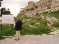
- The prominent remains of the castle high on a rock above the town,
- The city walls,
- A large water tank (Tekir ambarı) cut into the rock,
- An extensive necropolis of rock-cut tombs with inscriptions.
-
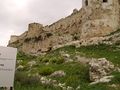 Outer walls of the castle of Silifke
 -
 Silifke castle
 -
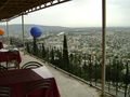 Bar next to the castle of Silifke
 -
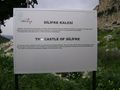 Touristic panel describing the castle of Silifke
 -
-
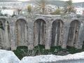 Tekir ambarı cistern
 -

-
-

-

-

-

-

-

-

-


الحياة والثقافة
The Turkmen community of Silifke has a strong tradition of folk music and dance including songs such as The Yogurt of Silifke (where the dancers imitate the actions of making yogurt) and another one where they wave wooden spoons about as they dance.
The cuisine includes breakfast of leaves of unleavened bread (bazlama) with a dry sour cottage cheese (çökelek) or fried meats. Many other dishes feature bulgur wheat. The annual Silifke Yoghurt Festival takes place in May.
انظر أيضاً
- السلوقيات الأخرى
- Acacius of Caesarea
- كنيسة المشرق الآشورية
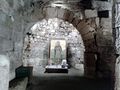
- Aya Tekla Church
- Council of Rimini
- Cyprus Memorial Cemetery in Silifke
- Çukurova
- Dana Adası
- Eudoxius of Antioch
- Işıkkale
- Karakabaklı
- Gökkale
- Meydankale
- Narlıkuyu
- الإمبراطورية السلوقية
- Silifke Museum
- Sinekkale
- Uzuncaburç
- Silifke Castle
- Silifke Göksu Anadolu Lisesi
المراجع
- ^ "Area of regions (including lakes), km²". Regional Statistics Database. Turkish Statistical Institute. 2002. Retrieved 2013-03-05.
- ^ "Population of province/district centers and towns/villages by districts - 2012". Address Based Population Registration System (ABPRS) Database. Turkish Statistical Institute. Retrieved 2013-02-27.
- ^ أ ب
 Chisholm, Hugh, ed. (1911). . دائرة المعارف البريطانية. Vol. 24 (eleventh ed.). Cambridge University Press. p. 603.
 {{cite encyclopedia}}: Cite has empty unknown parameter:|coauthors=(help) - ^ Stephanus of Byzantium; Strabo, XIV, 670)
- ^ http://www.weatherbase.com/weather/weatherall.php3?s=3371&refer=&units=metric&cityname=Silifke-Turkey
- هذه المقالة تضم نصاً من مطبوعة هي الآن مشاع: هربرمان, تشارلز, ed. (1913). . الموسوعة الكاثوليكية. Robert Appleton Company.
{{cite encyclopedia}}: Cite has empty unknown parameters:|1=,|coauthors=, and|month=(help); Invalid|ref=harv(help)
وصلات خارجية
- District governor's official website (لغة تركية)
- District municipality's official website (لغة تركية)
- Silifke Guide and Photo Album
- susanoğlu
- Extensive photo site of Silifke, the temple and nearby sights
| المقاطعات الحضرية |   | |
|---|---|---|
| المقاطعات الريفية | ||
المناطق | ||
| إيجه | ||
| البحر الأسود | ||
| وسط الأناضول | ||
| شرق الأناضول | ||
| مرمرة | ||
| البحر المتوسط | ||
| جنوب شرق الأناضول | ||
- Pages using gadget WikiMiniAtlas
- مقالات المعرفة المحتوية على معلومات من دائرة المعارف البريطانية طبعة 1911
- Short description is different from Wikidata
- Coordinates on Wikidata
- Articles containing Ancient Greek (to 1453)-language text
- Articles containing لاتينية-language text
- Pages using Lang-xx templates
- Articles incorporating text from the 1913 Catholic Encyclopedia with Wikisource reference
- مقاطعات محافظة مرسين
- Çukurova
- أماكن مأهولة في محافظة مرسين
- مستعمرات سلوقية في الأناضول
- Catholic titular sees in Asia
- Districts of Mersin Province