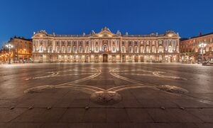
ميدي-پيريني
Midi-Pyrénées | |
|---|---|
 | |
| Country | |
| Dissolved | 1 January 2016 |
| Prefecture | Toulouse |
| Departments | |
| الحكومة | |
| • President | Martin Malvy (PS) |
| المساحة | |
| • الإجمالي | 45٬348 كم² (17٬509 ميل²) |
| التعداد (1 January 2012) | |
| • الإجمالي | 2٬926٬592 |
| • الكثافة | 65/km2 (170/sq mi) |
| منطقة التوقيت | UTC+1 (CET) |
| • الصيف (التوقيت الصيفي) | UTC+2 (CEST) |
| ISO 3166 code | FR-N |
| GDP (2012)[1] | Ranked 8th |
| Total | €79.9 billion (US$102.7 bn) |
| Per capita | €27,198 (US$34,982) |
| NUTS Region | FR6 |
| الموقع الإلكتروني | Midi-Pyrenees Region |
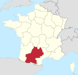
ميدي-پيريني ( Midi-Pyrénées ؛ النطق الفرنسي: [midi piʁene] (![]() استمع)؛ أوكسيتان: Miègjorn-Pirenèus [mjɛdˈdʒuɾ piɾeˈnɛws] أو Mieidia-Pirenèus [mjejˈði.ɔ piɾeˈnɛws]؛ إسپانية: Mediodía-Pirineos) هو أكبر مناطق فرنسا حسب المساحة، والتي تزيد عن مساحة هولندا أو الدنمارك.
استمع)؛ أوكسيتان: Miègjorn-Pirenèus [mjɛdˈdʒuɾ piɾeˈnɛws] أو Mieidia-Pirenèus [mjejˈði.ɔ piɾeˈnɛws]؛ إسپانية: Mediodía-Pirineos) هو أكبر مناطق فرنسا حسب المساحة، والتي تزيد عن مساحة هولندا أو الدنمارك.
Midi-Pyrénées has no historical or geographical unity. It is one of the regions of France created in the late 20th century to serve as a hinterland and zone of influence for its capital, Toulouse, one of a handful of so-called "balancing metropolises" (métropoles d'équilibre).[2] Another example of this is the region of Rhône-Alpes which was created as the region for Lyon.
البنية الجغرافية

تاريخياً، تتألف ميدي-بيريني من عدة مقاطعات فرنسية سابقة:
- 24.2% of the Midi-Pyrénées territory formed part of Gascony: western half of Haute-Garonne department, southwest of Tarn-et-Garonne, Gers in its entirety, extreme north of Hautes-Pyrénées. Gascony here includes the province of Comminges, which historically was a Pyrenean province, but later expanded all the way north to Muret in the southern suburbs of Toulouse, then was fragmented, and became an eastern fringe of Gascony. Gascony also extends over the Aquitaine region.
- 23.4% of Midi-Pyrénées was part of Languedoc: the eastern half of Haute-Garonne, southeast of Tarn-et-Garonne, Tarn in its entirety, northwest and northeast of Ariège. Languedoc includes the sub-province of Albigeois (Tarn department), which is sometimes considered as a province separate from Languedoc. Languedoc also extends over the Languedoc-Roussillon region.
- 19.9% of Midi-Pyrénées was formerly Rouergue: Aveyron department in its entirety, and extreme east of Tarn-et-Garonne. The former province of Rouergue lay entirely within the modern Midi-Pyrénées.
- 15.4% of Midi-Pyrénées was Quercy: department of Lot in its entirety, and northern half of Tarn-et-Garonne. The province of Quercy was entirely contained inside Midi-Pyrénées.
- 16.6% of Midi-Pyrénées was a collection of small Pyrenean provinces, from east to west: the County of Foix (eastern half of Ariège), Couserans (western half of Ariège), Nébouzan (extreme south of Haute-Garonne and extreme east of Hautes-Pyrénées), Quatre-Vallées (i.e. "Four Valleys") (east of Hautes-Pyrénées), and Bigorre (west and center of Hautes-Pyrénées). All these provinces are entirely contained inside Midi-Pyrénées.
- 0.5% of Midi-Pyrénées is Agenais: extreme west of Tarn-et-Garonne. Agenais extends essentially over the Aquitaine region.
The historical makeup of Midi-Pyrénées is even more complex, as the provinces listed here are further subdivided into pays–used interchangeably in French for country, area, land, etc.–each with its own particular identity, such as Armagnac, Astarac, or Lomagne inside the Gascogne part of Midi-Pyrénées, Lauragais or Volvestre inside the Languedoc part of Midi-Pyrénées, Bonezan inside County of Foix, Lavedan inside Bigorre, and so on.
The Pyrenean provinces of Couserans, Nébouzan, Quatre-Vallées, and Bigorre (but not the County of Foix) are sometimes considered to be part of Gascony. These provinces were all formed from the old Roman province of Novempopulana, later known as Vasconia (because of the Basque influence), and later as Gascony, from which they seceded over time. Furthermore, after the 16th century these Pyrenean provinces were made part of the military region of Gascony, and later in the 18th century they were ruled from Auch by the intendant of Auch, as with the rest of Gascony. If these Pyrenean provinces are included inside Gascony, then 35.4% of Midi-Pyrénées is Gascony, outweighing Languedoc and its 23.4%.
This point is still a matter of debate. The Pyrenean provinces developed strong peculiarities over time, protected by their isolated valleys, and they looked quite distinct from the rest of Gascony. What's more, Bigorre, Quatre-Vallées, Nébouzan, and even Comminges kept their provincial states until the French Revolution, while Gascony had no provincial states. These Pyrenean provinces sent their representatives to the Estates-General of 1789 in Versailles at the beginning of the Revolution, whereas the various other parts of Gascony sent their own representatives.
In demographic terms, given the overwhelming demographic weight of Toulouse (located in the historical Languedoc), the majority of the inhabitants of Midi-Pyrénées live in the Languedoc part of Midi-Pyrénées. As a matter of fact, the historical flag of Languedoc, the Occitan cross, was adopted as the official flag of the Midi-Pyrénées region by the regional council. هذا التصميم التاريخي هو نفسه مشتق من درع كونتية تولوز القديمة.
عناصر الوحدة
In the Middle Ages, most of what is now Midi-Pyrénées was ruled at some time or another by s (such as in the case of Foix). After the French conquest in the 13th century, the county of Toulouse was dismantled, and eventually Languedoc was born as a remnant of the old county, but quite smaller than it. Nonetheless, until the French Revolution the Parlement (supreme court of justice) of Toulouse extended its jurisdiction over not just Languedoc, but also all the other territories that are now Midi-Pyrénées. Thus, towns like Tarbes (Bigorre), Auch (Gascony), or Rodez (Rouergue) were already under the jurisdiction of Toulouse before the Revolution, although only for judicial and legal matters.
الهوية
Despite all these differences, it is wrong to assume that Midi-Pyrénées exists only on paper. Since the region was created in the 1970s, a certain sense of a "Midi-Pyrenean" identity has emerged. Inhabitants of the region share common cultural or social features, some of them not just particular to Midi-Pyrénées, but common to the whole of southwest France, such as an interest in Rugby union: the south-west of France is even called The Land of the Oval Ball (فرنسية: Pays de l'Ovalie). There are images that come spontaneously to the mind of Midi-Pyrénées people when thinking about their region, such as the Airbus planes leaving their factories in Toulouse, the snowy peaks of the Pyrenees, or a game of rugby. These three images were used for some time by the regional council in video clips to promote the distinct identity of the region. The regional council has also played a key role in developing a network of motorways/freeways to bring all the different areas of Midi-Pyrénées together. As of 2005, there are seven motorways/freeways that radiate from Toulouse and link all the most distant corners of the region with its capital city (with two of these seven motorways/freeways only partly built and scheduled to be completed by 2010-2015). A network of Regional Express Trains was also set up by the regional council to ensure frequent train connections between the different parts of the region.
التوزيع السكانى
السياسة
الاقتصاد
Midi-Pyrénées is the largest region of France. It occupies a strategic position between the Mediterranean Sea and the Atlantic Ocean. In 2006 its total GDP was $87.915 billion for a population of 2,755,000. It had a GDP per capita of $32,519 a year with an unemployment of 8.9%, the GDP per employment equal to $80,103 a year. The economy of Midi-Pyrénées can be divided into three sectors.
Primary sector: Because of its size Midi-Pyrénées has the largest number of farms of all France with 60,000 farms in active use. It has also the largest amount of land readily usable with 2.6 million hectares. This is however being reduced by both the increasing population and the CAP. The departments of the Gers, Aveyron, Lot and Tarn-et-Garonne have the most significant agricultural activity of the region. Wine production has suffered in recent years from declining demand, reducing prices and over-production. There are 19 AOC wines in the region. A policy of merging producers into wider groups has been initiated.
Secondary sector: The second largest part of the industrial production of the region is the food industry. 4.6bn Euros are generated each year from agriculture. It is however evolving as it received the fourth largest amount of foreign investment of France and is the region of France that created the largest number of enterprises in 2005 with 14,398 new enterprises. Excluding the construction and civil engineering field the secondary sector uses 15% of the regional resources. There are several groups who have important offices and structures in the region like: Airbus, EADS, Alcatel, Siemens, Bosch and Pierre Fabre. Aerospace industry is an important source of income for the region and employs 57,000 people not to mention all the surrounding enterprises (more than 3,000) which work on the engineering, electronic, telecommunication and computing infrastructure for this industry. However, there is a large restructuring plan ongoing and about 10,000 new jobs are expected to be lost outright and partners will be regrouped into larger entities.
Tertiary sector: The region has been behind the other French regions for a long time on services. However this has changed a lot in the recent years and there are many important consulting and telemarketing companies based in the area or with important offices, such as Orange, IBM and CapGemini. It is Toulouse, the largest city and capital, that currently concentrates the largest amount of employment however with the progressive extensions of transportation this has been grown considerably in recent years. In late 2006 a large plan was initiated to replace older train, the circulation of regional train has kept on increasing and has now reach the amount of ten million journeys each year. With 80,000 students and 15,000 scientists divided into 400 laboratories the region ranks in France's top three for scientific research. Technology transfers to small-business-enterprises is therefore substantial. Tourism is an important source of incomes for the region, partly due to a sunny climate and the presence of the Pyrénées. It is well known for its gastronomy and quality of life. Aside of casual tourism the small town of Lourdes, because of religious pilgrimage, is France's second largest tourist destination after Paris and has more hotels than any other city but Paris.
الاندماج مع لانگدوك-روسيون
أهم المدن
انظر أيضاً
وصلات خارجية
هوامش
¹ In the 1960s, eight large regional cities of France (Toulouse, Lille, Nancy, Strasbourg, Lyon, Nantes, Bordeaux, and Marseille) were made "balancing metropolises", receiving special financial and technical help from the French government in order to counterbalance the excessive weight of Paris inside France.
43°30′N 1°20′E / 43.500°N 1.333°E
- ^ INSEE. "Produits intérieurs bruts régionaux et valeurs ajoutées régionales de 1990 à 2012". Retrieved 2014-03-04.
- ^ In the 1960s, eight large regional cities of France (Toulouse, Lille, Nancy, Strasbourg, Lyon, Nantes, Bordeaux, and Marseille) were made "balancing metropolises", receiving special financial and technical help from the French government in order to counterbalance the excessive weight of Paris inside France.
- Pages using gadget WikiMiniAtlas
- Short description is different from Wikidata
- Pages using infobox settlement with no coordinates
- Articles containing أوكسيتان (بعد 1500)-language text
- Pages using Lang-xx templates
- Pages with plain IPA
- Articles containing إسپانية-language text
- Articles containing فرنسية-language text
- Coordinates on Wikidata
- ميدي-پيريني
- مناطق فرنسا
- أقاليم التصنيف الثاني في الاتحاد الأوروپي


