إنگوليتس
| إنگوليتس | |
|---|---|
 | |
 | |
خطأ: إحداثيات غير صالحة. | |
| أصل الاسم | Turkic iyen-kul, "wide lake"[1] |
| الاسم المحلي | Inhulets, Інгулець Error {{native name checker}}: parameter value is malformed (help) |
| الموقع | |
| البلد | أوكرانيا |
| السمات الطبيعية | |
| Source | |
| • location | أوبلاست كيروڤوگراد، أوكرانيا |
| المصب | |
- الموقع | دنيپر |
• الإحداثيات | 46°41′03″N 32°48′45″E / 46.6842°N 32.8125°E |
| الطول | 557 km (346 mi)[2] |
| مساحة الحوض | 14،460 km2 (5،580 sq mi)[2] |
| سمات الحوض | |
| السريان | قالب:RDnieper |
| خطأ: الوظيفة "main" غير موجودة. | |
الإنگوليتس (أوكرانية: Інгулець ؛ إنگليزية: Inhulets) هو نهر، رافد أيمن للدنيپر، يجري في أوكرانيا. ويبلغ طوله 557 كم ومساحة حوض تصريفه 14,460 كم².[2]
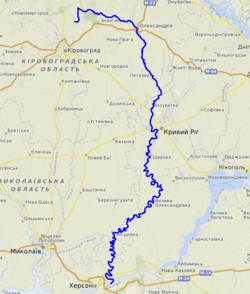
The Inhulets has its source in the Dnieper Upland in a ravine (balka) to the west from village Topylo,[2] Kropyvnytskyi Raion in the Ukrainian province of Kirovohrad, about 30 km away from the Dnieper river itself, to which it flows parallel. The Inhulets then turns south, where it flows through Kryvbas Iron Ore Basin, and the Kherson and Mykolaiv Oblasts, before finally flowing into the Dnieper about 30 km east of the city of Kherson. The river flows through southern spurs of the Dnieper Uplands and then across the Black Sea Lowland.[2] The upper portion of the Inhulets basin is in the forest steppe zone, the lower part within the Pontic steppe.[2]
While flowing near the city of Kryvyi Rih, the course of the river has created many small islands, which have a rich vegetation. However, the vegetation is impaired by the high level of contamination of the river, due to the nearby iron ore mining industry.
Urban localities located on the river include Oleksandriia, Kryvyi Rih, Shyroke, Inhulets (former city merged with Kryvyi Rih), and Snihurivka.
FC Inhulets Petrove is a professional football team in Ukraine that is named after the river.
الروافد
المراجع
- ^ Schevchuk, V. Y. (July 29, 2005). Preserving the Dnipro River: Harmony, History and Rehabilitation. IDRC. ISBN 9781552501382 – via Google Books.
- ^ أ ب ت ث ج ح Zelenska, L., Demianov, V. Inhulets (ІНГУЛЕ́ЦЬ). Encyclopedia of Modern Ukraine. 2011
وصلات خارجية
- Zelenska, L., Demianov, V. Inhulets (ІНГУЛЕ́ЦЬ). Encyclopedia of Modern Ukraine. 2011
- Pages using gadget WikiMiniAtlas
- Short description is different from Wikidata
- Native name checker template errors
- Coordinates on Wikidata
- Articles containing أوكرانية-language text
- Pages using Lang-xx templates
- Articles containing إنگليزية-language text
- Rivers of Dnipropetrovsk Oblast
- Rivers of Kherson Oblast
- Rivers of Kirovohrad Oblast
- Rivers of Kryvyi Rih
- Rivers of Mykolaiv Oblast
