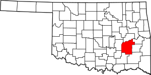
مقاطعة پتسبرگ، أوكلاهوما
Pittsburg County | |
|---|---|
 الموقع ضمن ولاية Oklahoma | |
 موقع Oklahoma ضمن الولايات المتحدة | |
| الإحداثيات: 34°56′N 95°45′W / 34.93°N 95.75°W | |
| البلد | |
| State | |
| تأسست | 1907 |
| Seat | McAlester |
| المساحة | |
| • الإجمالي | 1٬378 ميل² (3٬570 كم²) |
| • البر | 1٬306 ميل² (3٬380 كم²) |
| • الماء | 72 ميل² (190 كم²) 5.22%% |
| التعداد (2010) | |
| • الإجمالي | 45٬837 |
| • الكثافة | 30/sq mi (13/km2) |
مقاطعة پتسبرگ إنگليزية: Pittsburg County هي إحدى مقاطعات ولاية أوكلاهوما في الولايات المتحدة الأمريكية.
المقاطعات المجاورة
- McIntosh County (north)
- Haskell County (northeast)
- Latimer County (east)
- Pushmataha County (southeast)
- Atoka County (south)
- Coal County (southwest)
- Hughes County (west)
السكان
| Voter Registration and Party Enrollment as of January 15, 2012[1] | |||||
|---|---|---|---|---|---|
| Party | Number of Voters | Percentage | |||
| الديمقراطي | 18,155 | 69.42% | |||
| الجمهوري | 5,272 | 20.16% | |||
| Unaffiliated | 2,725 | 10.42% | |||
| Total | 26,152 | 100% | |||
السياسة
| Year | الجمهوري | Democrat |
|---|---|---|
| 2008 | 68.29% 11,752 | 31.71% 5,457 |
| 2004 | 59.91% 11,134 | 40.09% 7,452 |
| 2000 | 52.05% 8,514 | 46.63% 7,627 |
المدن والبلدات
NRHP sites
The following sites in Pittsburg County are listed on the National Register of Historic Places:
|
|
الهامش
- ^ http://www.ok.gov/elections/documents/reg_0112.pdf
- ^ "Dave Leip's Atlas of U.S. Presidential Elections". Retrieved 2011-06-11.
?
تصنيفات:
- Pages using gadget WikiMiniAtlas
- Short description is different from Wikidata
- مقاطعات Oklahoma
- U.S. Counties Missing Ex Image
- Articles containing إنگليزية-language text
- Pages using Lang-xx templates
- Articles with hatnote templates targeting a nonexistent page
- Coordinates on Wikidata
- Oklahoma counties
- Pittsburg County, Oklahoma
- 1907 establishments in the United States
- Populated places established in 1907
- مقاطعات أوكلاهوما
