كانتون زولوتورن
Canton of Solothurn
Kanton Solothurn (ألمانية) Canton of Soleure | |
|---|---|
 | |
| الإحداثيات: 47°9′N 7°38′E / 47.150°N 7.633°E | |
| Capital | Solothurn |
| Largest city | Olten |
| Subdivisions | 122 municipalities، 10 districts |
| الحكومة | |
| • Executive | Regierungsrat (5) |
| • Legislative | Kantonsrat (100) |
| المساحة | |
| • الإجمالي | 790٫45 كم² (305٫19 ميل²) |
| التعداد | |
| • الإجمالي | قالب:Swiss populations data CH-SO |
| ISO 3166 code | CH-SO |
| Highest point | 1،445 m (4،741 ft): Hasenmatt |
| Lowest point | 277 m (909 ft): Birs at the cantonal border in Dornach |
| Joined | 1481 |
| Languages | German |
| الموقع الإلكتروني | www |
زولوتورن (بالألمانية: Solothurn رومانش: Chantun Soloturn فرنسية: Canton de Soleure; إيطالية: Canton Soletta)، أحد كانتونات سويسرا. ويقع في شمال غرب البلاد. عاصمتها زولوتورن.
التاريخ
The foundation of the village of Salodurum took place in the time of the Roman emperor Tiberius. The territory of the canton comprises land acquired by the former town, mainly in the Middle Ages. For that reason the shape of the canton is irregular and includes two exclaves along the French border, separated from the rest of the canton by Basel-Land, which form separate districts of the canton. In 1481, the canton became a member of the military alliance of the former Swiss confederation. At the end of the Reformation, Solothurn maintained its Catholic religion. Between 1798 and 1803 the canton was part of the Helvetic Republic. In 1803 Solothurn was one of the 19 Swiss cantons that were reconstituted by Napoleon (Mediation). In 1830, the population rebelled against the aristocratic regime and the canton became definitely liberal-democratic. Even though the population was strictly Roman Catholic, Solothurn did not join the Catholic separatist movement (Sonderbund) in 1845–7. Similarly, the federal constitutions of 1848 and 1874 were approved. The current constitution of the canton dates from 1987.
الجغرافيا
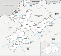
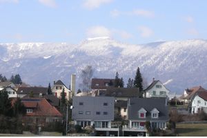
The canton is located in the north-west of Switzerland. To the west and south lie the cantons of Jura and Bern, to the east is Aargau. To the north the canton is bounded by the canton of Basel-Landschaft. Parts of two of the districts are exclaves and are located along the border of France (Grand Est). The lands are drained by the Aare river and its tributaries. The landscape is mostly flat, but it includes the foothills of the Jura massif. Part of this, the massif of the Weissenstein, overlooks Solothurn and the Mittelland from the north and has views of the Bernese Alps. The flat lands are a plain created by the Aare river. The total area of the canton is 791 km².
التقسيمات السياسية
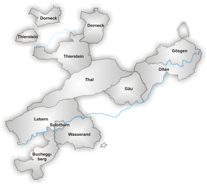
الأحياء
البلديات
يتكون كانتون سولوتورن من 128 بلدية (اعتبارا من 2009[تحديث]).[2]
الديموغرافيا
الاقتصاد
النقل
وصلات خارجية
- Official site (بالألمانية)
- Official statistics
 Media related to Canton of Solothurn at Wikimedia Commons
المصادر
- ^ Arealstatistik Land Cover - Kantone und Grossregionen nach 6 Hauptbereichen accessed 27 October 2017
- ^ "Liste officielle des communes de la Suisse - 01.01.2008". Retrieved 15 décembre 2008.
{{cite web}}: Check date values in:|accessdate=(help); Unknown parameter|site=ignored (help)
- Pages using gadget WikiMiniAtlas
- CS1 errors: unsupported parameter
- Short description is different from Wikidata
- Use dmy dates from July 2021
- Articles containing ألمانية-language text
- Hidden templates using styles
- Coordinates on Wikidata
- Pages using infobox settlement with missing country
- Articles containing رومانش-language text
- Pages using Lang-xx templates
- Articles containing فرنسية-language text
- Articles containing إيطالية-language text
- Articles with hatnote templates targeting a nonexistent page
- مقالات فيها عبارات متقادمة منذ 2009
- جميع المقالات التي فيها عبارات متقادمة
- كانتون زولوتورن
- كانتونات سويسرا
- Cantons of the Helvetic Republic
- صفحات مع الخرائط
