ڤوكوڤار
ڤوكوڤار
Вуковар Vukovar | |
|---|---|
| مدينة ڤوكوڤار Grad Vukovar Град Вуковар | |
|
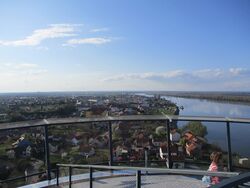
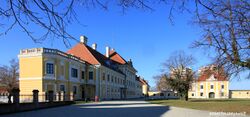
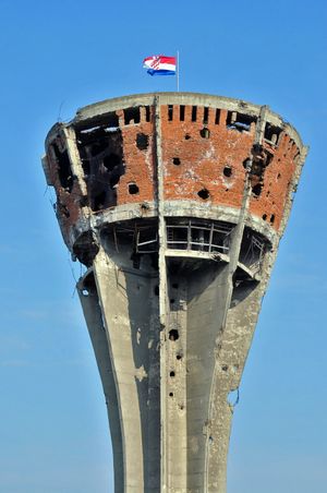
مع عقارب الساعة، من أعلى: منظر پانورامي لڤوكوڤار ونهر الدانوب؛ وسط البلد مع arcades; برج الماء بڤوكوڤار؛ Eltz Manor؛ دير الفرنسسكان مع كنيسة القديسين فيليپ وجيمس وقاعة العمال | |
| الكنية: Grad Heroj (Hero City) | |
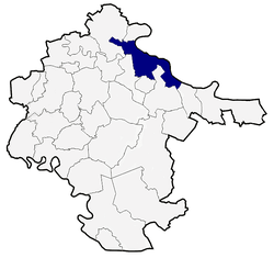 موقع بلدية ڤوكوڤار | |
| الإحداثيات: 45°21′00″N 19°00′12″E / 45.35000°N 19.00333°E | |
| البلد | |
| المنطقة | Podunavlje |
| المقاطعة | |
| الحكومة | |
| • العمدة | Ivan Penava (HDZ) |
| • مجلس المدينة | 23 members
|
| المساحة | |
| • مدينة | 100٫26 كم² (38٫71 ميل²) |
| المنسوب | 108 m (354 ft) |
| التعداد (2011)[1] | |
| • مدينة | 27٬683 |
| • الكثافة | 280/km2 (720/sq mi) |
| • Urban | 26٬468 |
| منطقة التوقيت | UTC+1 (CET) |
| • الصيف (التوقيت الصيفي) | UTC+2 (CEST) |
| Postal code | 32 000 |
| مفتاح الهاتف | 032 |
| لوحة السيارة | VU |
| الموقع الإلكتروني | www |
ڤوكوڤار (Vukovar ؛ النطق الصربو-كرواتي: [ʋûkoʋaːr]؛ سيريلية صربية: Вуковар[Note 1]) هي مدينة في شرق كرواتيا. وتضم أكبر ميناء نهري في كرواتيا، إذ تقع عند التقاء نهري ڤوكا والدانوب. ڤوكوڤار هي مقر مقاطعة ڤوكوڤار-صرميا. التعداد المسجل للمدينة كان 26,468 نسمة في تعداد 2011، بإجمالي 27,683 في البلدية.[1]
الاسم
The name Vukovar means 'town on the Vuka River' (Vuko from the Vuka River, and vár from the Hungarian word for 'fortress'). The river was called "Ulca" in antiquity, probably from an Illyrian language. Its name might be related to the name of the river "Volga".[2] Folk etymology has connected it to the Croatian word "vuk", meaning "wolf". In other languages, the city in German is known as Wukowar and in Hungarian as Vukovár or Valkóvár. In the late 17th century, the medieval Croatian name Vukovo was supplanted by the Hungarian Vukovár.[3]
المنطقة البلدية
Historically, Vukovar was divided into the Old Vukovar, New Vukovar and former workers' Bata village with Bata Shoes (now Borovo) factory, today known as the Vukovar suburb Borovo Naselje.
الجغرافيا
 صورة ساتلية لڤوكوڤار على نهر الدانوب. |
تقع ڤوكوڤار في الجزء الشرقي من جمهورية كرواتيا وهي مركز مقاطعة ڤوكوڤار -صرميا. وموقعها يضعها على الحدود بين المقاطعتين التاريخيتين شرق سلاڤونيا وغرب صرميا.
The city is positioned on important transport routes. Since time immemorial transport routes from the northwest to the southeast were active in the Danube Valley through the Vukovar area.
After steam ships were introduced in the mid-19th century, and with the arrival of present-day tourist ships, Vukovar is connected with Budapest and Vienna upstream and all the way to Romania downstream. The Vukovar harbour is an important import and export station. The Danube has always been and remains the connection of the people of Vukovar with Europe and the world.
Vukovar is located 20 km (12 mi) northeast of Vinkovci and 36 km (22 mi) southeast of Osijek, with an elevation of 108 m (354 ft). Vukovar is located on the main road D2 Osijek—Vukovar—Ilok and on the Vinkovci—Vukovar railway (and road D55).
التاريخ
قبل التاريخ
One Scordisci archaeological site in Vukovar dating back to late La Tène culture was excavated in the 1970s and 1980s as a part of rescue excavations in eastern Croatia.[4] Archaeological site was a part of the settlement network of Scordisci in the area of Vinkovci.[4]
التاريخ المبكر
Slavic tribes settled in this area in the 6th century. In the 9th century the region was part of the Slavic Balaton Principality ruled by prince Pribina, part of the إمارة كرواتيا الپانونية ruled by prince Ljudevit, and part of the الامبراطورية البلغارية. In the 11th–12th century, the region was part of the Kingdom of Croatia; from the 13th to 16th century part of the مملكة المجر; and between 1526-1687[5] under Ottoman rule.
ملكية هابسبورگ ويوغسلاڤيا
بعد معاهدة كارلوڤچه في 1699، كانت ڤوكوڤار جزءاً من ملكية هابسبورگ، سلاڤونيا (ترانسليثانيا بعد تسوية 1867)، وبعد ذلك سريعاً في مملكة كرواتيا-سلاڤونيا، خـُلِقت في مملكة سلاڤونيا ومملكة كرواتيا اندمجتا في 1868.
في أواخر القرن 19 وأوائل القرن العشرين، كانت ڤوكوڤار مقر مقاطعة صرميا في مملكة كرواتيا-سلاڤونيا.
حرب الاستقلال الكرواتية

تضررت ڤوكوڤار بشدة أثناء حرب الاستقلال الكرواتية. Approximately 2,000 self-organised defenders (the army of Croatia was still in an embryonic stage at that time) defended the city for 87 days against approximately 36,000 troops of the Serb-dominated JNA supplemented with 110 vehicles and tanks and dozens of planes. The city suffered heavy damage during the siege and was eventually overrun. It is estimated that 2,000 defenders of Vukovar and civilians were killed, 800 went missing and 22,000 civilians were forced into exile.[6]
نتيجة النزاع، يوجد فالق عرقي عميق بين السكان الكروات والصرب.
الديمغرافيا
| السنة | تعداد | ±% |
|---|---|---|
| 1857 | 8٬162 | — |
| 1869 | 9٬453 | +15.8% |
| 1880 | 10٬234 | +8.3% |
| 1890 | 11٬205 | +9.5% |
| 1900 | 11٬557 | +3.1% |
| 1910 | 12٬149 | +5.1% |
| 1921 | 12٬116 | −0.3% |
| 1931 | 12٬738 | +5.1% |
| 1948 | 18٬994 | +49.1% |
| 1953 | 20٬616 | +8.5% |
| 1961 | 25٬763 | +25.0% |
| 1971 | 38٬830 | +50.7% |
| 1981 | 41٬959 | +8.1% |
| 1991 | 46٬735 | +11.4% |
| 2001 | 31٬670 | −32.2% |
| 2011 | 27٬683 | −12.6% |
| Source: Naselja i stanovništvo Republike Hrvatske 1857–2001, DZS, Zagreb, 2005 & Popis stanovništva 2011 | ||
| Year | Total | Croats | Serbs | Germans | Hungarians | Others | |||||
|---|---|---|---|---|---|---|---|---|---|---|---|
| 2011 | 27,683 | 15,881 | 57.37% | 9,654 | 34.87% | 58 | 0.21% | 347 | 1.25% | 1,743 | 6.30% |
| 2001 | 31,670 | 18,199 | 57.5% | 10,412 | 32.9% | 58 | 0.2% | 387 | 1.2% | 2,614 | 8.3% |
| 1990 | 44,639 | 21,065 | 47.2% | 14,425 | 32.3% | 94 | 0.2% | 694 | 1.5% | 8,361 | 18.8% |
| 1971 | 30,222 | 14,694 | 48.6% | 9,132 | 30.2% | 60 | 0.2% | 835 | 2.8% | 5,501 | 18.2% |
| 1948 | 17,223 | 10,943 | 63.5% | 4,390 | 25.5% | 54 | 0.3% | 913 | 5.3% | 923 | 5.3% |
| 1931 | 10,242 | 5,048 | 49.6% | 1,702 | 16.6% | 2,670 | 26.1% | 571 | 5.6% | 215 | 2.0% |
| 1910 | 10,359 | 4,092 | 39.5% | 1,628 | 15.7% | 3,503 | 33.8% | 954 | 9.2% | 183 | 1.8% |
The most significant change was the forced displacement and internment of the German civilian population after World War II. The confiscated houses and properties were given to Croat and Serb colonists during the years of Communist Yugoslavia.
| Year of census | total | Croats | Serbs | Others |
|---|---|---|---|---|
| 2001 | 31,670 | 18,199 (57.46%) | 10,412 (32.88%) | 3,059 (9.66%) |
| 1991 | 84,024 | 36,910 (43.93%) | 31,910 (37.98%) | 15,204 (18.09%) |
| 1981 | 81,203 | 30,157 (37.14%) | 25,146 (30.97%) | 25,903 (31.89%) |
| 1971 | 76,602 | 34,629 (45.21%) | 28,470 (37.17%) | 13,593 (17.09%) |
| 1961 | 54,707 | 24,527 (44.83%) | 22,774 (41.63%) | 7,406 (13.54%) |
أحداث
الاقتصاد

Vukovar port is situated on 1،335 كيلومتر (830 ميل) of the downstream flow of Danube river, on its right coast, and is the biggest official concessioner in the Vukovar region. The Company focuses its business on the transshipment of general and bulk cargo. The Port (850m long and 45m wide) is conveniently situated on the main current of the river, enabling navigation throughout the whole year regardless of water level. The Port recorded productivity growth and increase in cargo transshipment from 123,570 tons in 2009 to 295,199 tons in 2011. The majority of transshipment was in the category of bulk cargo (237,119 tons in 2011), while packaged goods and heavy cargo accounted for a total of 58,080 tons.
The economy of Vukovar is based on agriculture, trade, viticulture, food industry, textile industry, building materials industry, footwear industry and tourism. Vukovar is the largest Croatian town and river port on the Danube. Its economy is based on trade, farming, viticulture, livestock breeding, textiles, the food-processing industry, the footwear industry and tourism.
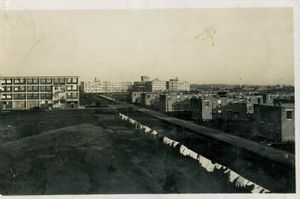
Borovo, a manufacturer of footwear located in Vukovar, ended up devastated and demolished in 1991 during the war. In its prime it employed 24,000 employees and tried to break into foreign markets with innovations in the manufacture of footwear, but today there are fewer than 1000 employees.
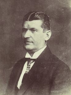
On June 7, 1931, Borovo was founded by Czech industrialist Tomáš Baťa. Borovo Factory was one of the few famous Bata Shoes factories in the world. In 1933, the production of rubber and technical goods started, and Bata in the gum industry became one of the first companies in the then Kingdom of Yugoslavia.
International relations
Foreign representatives
 The Consulate General of Republic of Serbia in the city of Vukovar.[10]
Twin towns — Sister cities
Notes
- ^ الاستخدام الرسمي للسيريلية الصربية في ڤوكوڤار هو موضع خلاف على مستوى السلطات المحلية والدولية، وهو مصدر الجدل السياسي الحالي. انظر #لغات الأقليات.
References
- ^ أ ب "Population by Age and Sex, by Settlements, 2011 Census: ڤوكوڤار". Census of Population, Households and Dwellings 2011. Zagreb: Croatian Bureau of Statistics. December 2012.
- ^ Antun, Mayer (1 April 1935). "Ime Mursa". Vjesnik Arheološkog muzeja u Zagrebu. 16 (1). Retrieved 3 April 2018.
- ^ Treasures of Yugoslavia, p.249.
- ^ أ ب Dizdar, Marko (2016). "Late La Tène Settlements in the Vinkovci Region (Eastern Slavonia, Croatia): Centres of Trade and Exchange" (PDF). Boii - Taurisci: Proceedings of the International Seminar, Oberleis-Klement, June 14th-15th, 2012. Austrian Academy of Sciences Press: 31–48. Retrieved 22 January 2019.
- ^ Treasures of Yugoslavia, published by Yugoslaviapublic, Beograd, available in English, German and Serbo-Croatian, 664 pages, 1980
- ^ Tucker, Spencer (2010). A Global Chronology of Conflict: From the Ancient World to the Modern Middle East. Santa Barbara, California: ABC-CLIO, LLC. p. 2617. ISBN 978-1-85109-667-1.
- ^ "Stanovništvo grada Vukovara" (in Croatian). Retrieved 4 May 2013.
{{cite web}}: CS1 maint: unrecognized language (link) - ^ "SAS Output". Dzs.hr. Retrieved 2009-06-23.
- ^ "Državni zavod za statistiku Republike Hrvatske". Dzs.hr. Retrieved 2013-03-12.
- ^ "Consulates- Vukovar, Croatia". mfa.gov.rs.
- ^ shegrt1. "Gradovi i općine prijatelji Grada Vukovara". vukovar.hr.
{{cite web}}: CS1 maint: numeric names: authors list (link)
Bibliography
- Cresswell, Peterjon; Atkins, Ismay; Dunn, Lily (10 July 2006). Time Out Croatia (First ed.). London, Berkeley & Toronto: Time Out Group Ltd & Ebury Publishing, Random House Ltd. 20 Vauxhall Bridge Road, London SV1V 2SA. ISBN 978-1-904978-70-1. Retrieved 10 March 2010.
وصلات خارجية
قالب:Vukovar قالب:Subdivisions of Vukovar-Srijem County قالب:County seats of Croatia
- Pages using gadget WikiMiniAtlas
- CS1 maint: numeric names: authors list
- Short description is different from Wikidata
- Coordinates on Wikidata
- Articles containing صربية-language text
- Articles with hatnote templates targeting a nonexistent page
- جميع الصفحات التي تحتاج تنظيف
- مقالات بالمعرفة تحتاج توضيح from July 2012
- ڤوكوڤار
- مدن كرواتيا
- أماكن مأهولة على الدانوب
- Populated places in Vukovar-Srijem County
- مقاطعة صرميا
- أماكن مأهولة في صرميا
- تأسيسات القرن 13 في كرواتيا
