شڤيت
شڤيت | |
|---|---|
 البلدة القديمة | |
 Coat of arms | |
موقع شڤيت within أوكرمارك district  | |
 شڤيت  شڤيت | |
| Coordinates: 53°03′N 14°16′E / 53.050°N 14.267°E | |
| البلد | ألمانيا |
| الولاية | براندنبورگ |
| District | أوكرمارك |
| Government | |
| • العمدة | Annekathrin Hoppe[1] (SPD) |
| Area | |
• Total | 252٫19 كم² (97٫37 ميل²) |
| Elevation | 6 m (20 ft) |
| Time zone | CET/CEST (UTC+1/+2) |
| Postal codes | 16303 |
| Dialling codes | 03332, 033336 |
| Vehicle registration | UM |
| Website | www |
شڤـِت (Schwedt أو Schwedt/Oder؛ النطق الألماني: [ˈʃveːt]) هي بلدة في براندنبورگ، في شمال شرق ألمانيا. بوضع رسمي Große kreisangehörige Stadt (بلدة رئيسية بالمقاطعة)، هي أكبر بلدة في مقاطعة أوكرمارك، وتقع بالقرب من نهر أودر، الذي يشكل الحدود مع پولندا.
عرض عام
 |
البلدة الزراعية سابقاً تضم الآن واحدة من أكبر مصافي النفط (PCK Raffinerie GmbH) في ألمانيا، تأسست في 1958 وترتبط بشبكة خط أنابيب دروژبا الروسية.[2] وهي مملوكة لشركة روس نفط الروسية. تستخدم المصفاة 20 مليون متر مكعب من الماء في العام لتكرير النفط.[3]
ويوجد مصنع ورق كبير (UPM) بالقرب من شڤـِت.[4] معظم الصناعات تواجدت في المنطقة البعيدة أثناء الحكم الشيوعي في عقدي 1960 و 1970.
تم بناء مناطق سكنية كبيرة للعمال المنتقلين إلى شڤـِت. نحو 9% من شقق البلدة هي في مباني خرسانية مسبقة التصنيع (Plattenbau) تعود إلى ذلك العهد. ولما فـُقِد الكثير من الوظائف بعد إعادة توحيد ألمانيا والعودة إلى اقتصاد السوق، فقدت شڤـِت ربع سكانها منذ 1990. وفي العقود الأخيرة، أصبحت شڤـِت بلدة نموذجية لهدم المساكن الجاهزة Plattenbau لمكافحة الإضمحلال الحضري.
الجغرافيا
Schwedt is situated in the east of the historic Uckermark region stretching from the Oder to the Havel River. It is situated on a sandur at the western edge of the Oder floodplain running along the German-Polish border, which in 1995 was declared as the Lower Oder Valley National Park nature reserve. Across the river and the border, about 10 km (6.2 mi) to the southeast, is the Polish town of Chojna. The nearest German towns are Angermünde (about 18 km (11 mi) to the west) and Gartz (18 km (11 mi) down the Oder).
التقسيمات المحلية
In a 1974 municipal reform, the neighbouring village of Heinersdorf was incorporated into Schwedt, followed by Blumenhagen, Gatow and Kunow in 1993, by Kummerow in 1998, by Criewen and Zützen in 2001, Stendell in 2002, the former town Vierraden in 2003, and Schöneberg in January 2021. With 252.19 km2 (97.37 sq mi) Schwedt is among the 100 largest German municipalities by area.
أقرب المدن والبلدات
Gartz (ألمانيا)، Penkun (ألمانيا)، Szczecin (پولندا)، Gryfino (پولندا)، Cedynia (پولندا)، Chojna (پولندا)، Mieszkowice (پولندا)، Moryń (پولندا)، Trzcińsko-Zdrój (پولندا)، Myślibórz (پولندا)، Pyrzyce (پولندا).
التاريخ
After the Migration Period, the area had been settled by Polabian Slavs. From 937 onwards the lands of the Slavic Ukrani tribes in the west were subdued by the Saxon forces of Margrave Gero and incorporated into his vast Marca Geronis, while the lands east of the Oder were held by Pomeranian tribes under sovereignty of the newly formed دوقية پولندا ruled by Duke Mieszko I. The Saxon Northern March was lost in the Great Slav Rising of 983, and not before 1147 the Saxon count Albert the Bear again invaded the lands on the Oder river, which remained disputed between the newly established Margraviate of Brandenburg and the Pomeranian dukes.
The settlement of Schwedt was first mentioned in a 1265 deed. In the course of the Brandenburg–Pomeranian conflict, the Brandenburg margrave Louis II the Roman ceded it to Duke Barnim III of Pomerania in 1354. It was again besieged by the first Hohenzollern margrave Frederick I in 1434, but to no avail. In 1481 the Thuringian counts of Hohnstein acquired the estates; they granted town privileges to Schwedt as well as to neighbouring Vierraden وقدموا الإصلاح الپروتستانتي.
The rise of Schwedt came to an end with the extinction of the Hohnstein counts in 1609 and the disastrous Thirty Years' War, when the town on the road from Stettin to Berlin was plundered several times. In 1631 King Gustavus Adolphus of Sweden, after landing in Pomerania, camped here on his way to the Battle of Breitenfeld. Six years later the Swedish field marshal Johan Banér set the town on fire, after its citizens refused to capitulate.
أثناء الحرب الشمالية العظمى، وُقـِّعت معاهدة شڤـِت في البلدة.
Near the end of World War II, over two months of heavy fighting destroyed an estimated 85 percent of the town, including the Schwedt Castle. The Soviet Army occupied Schwedt on April 26, 1945, two weeks before the final defeat of Nazi Germany.[5] Afterwards it formed part of East Germany. During the 1960s, the government of the DDR expanded housing and encouraged people to move to Schwedt, a trend that ended with the fall of Communism.
السكان
-
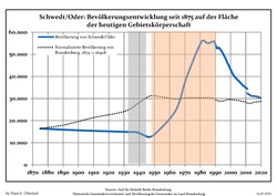 Development of population since 1875 within the current Boundaries (Blue Line: Population; Dotted Line: Comparison to Population development in Brandenburg state; Grey Background: Time of Nazi Germany; Red Background: Time of communist East Germany)
 -
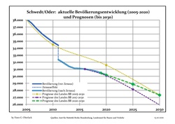 Recent Population Development and Projections (Population Development before Census 2011 (blue line); Recent Population Development according to the Census in Germany in 2011 (blue bordered line); Official projections for 2005–2030 (yellow line); for 2017–2030 (scarlet line); for 2020–2030 (green line)
|
|
|
البلدات التوأم – المدن الشقيقة
أشخاص بارزون

- Heinrich Schmelka (1777–1837), stage actor
- Leonhardt von Blumenthal (1810–1900), Prussian Field Marshal
- Karl von Schmidt (1817–1875), Prussian cavalry commander
- Paul von Hintze (1864–1941), naval officer, diplomat and politician
- Max Lemke (1895–1985), officer, Major-General last in World War II
- Heinz von Cleve (1897–1984), actor
- Horst Wendlandt (1922–2002), film producer
- Jörg Hoffmann (born 1970), freestyle swimmer
- Britta Steffen (born 1983), freestyle swimmer
المراجع
- ^ Landkreis Uckermark Wahl der Bürgermeisterin / des Bürgermeisters, accessed 7 March 2022.
- ^ "Möbel statt Braunkohle: Die größten Unternehmen in Brandenburg". manager magazin. 2019-08-28.
- ^ Heisterkamp, Lucia (16 September 2021). "Wo Brandenburger Industrie Millionen Kubikmeter Wasser verbraucht". www.rbb24.de (in الألمانية). Archived from the original on 19 September 2021.
- ^ "Möbel statt Braunkohle: Die größten Unternehmen in Brandenburg". manager magazin.
- ^ Schwedt war menschenleer. In: Märkische Oderzeitung. 27. April 2005
- ^ Detailed data sources are to be found in the Wikimedia Commons.Population Projection Brandenburg at Wikimedia Commons
- ^ "Partnerstadt". schwedt.eu (in الألمانية). Schwedt/Oder. Retrieved 2021-03-09.
وصلات خارجية
 Chisholm, Hugh, ed. (1911). . دائرة المعارف البريطانية (eleventh ed.). Cambridge University Press.
 {{cite encyclopedia}}: Cite has empty unknown parameter:|coauthors=(help)- Official website (in ألمانية)
- Official website (in إنگليزية)
- official website of National Park "Unteres Odertal" (in ألمانية)
- official website of PCK Raffinerie GmbH (in ألمانية)
قالب:Cities and towns in Uckermark (district)
| International | |
|---|---|
| National | |
- Pages using gadget WikiMiniAtlas
- CS1 الألمانية-language sources (de)
- Short description is different from Wikidata
- Coordinates on Wikidata
- Germany articles requiring maintenance
- Pages using infobox German location with unknown parameters
- Towns in Brandenburg
- مقالات المعرفة المحتوية على معلومات من دائرة المعارف البريطانية طبعة 1911
- Official website different in Wikidata and Wikipedia
- Articles with ألمانية-language sources (de)
- Articles with إنگليزية-language sources (en)
- Schwedt
- Localities in Uckermark (district)
- مقاطعة براندنبورگ
- Bezirk Frankfurt
- Germany–Poland border crossings
- مدن اشتراكية مخططة