سيتيا
Sitia
Σητεία | |
|---|---|
 | |
| الإحداثيات: 35°12′N 26°6′E / 35.200°N 26.100°E | |
| البلد | |
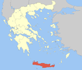
| المنطقة الادارية | كريت |
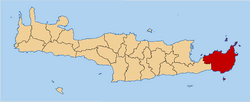
| الوحدة المحلية | لاسيثي |
| الحكومة | |
| • العمدة | Georgios Zervakis (منذ 2019) |
| المساحة | |
| • البلدية | 627٫1 كم² (242٫1 ميل²) |
| • الوحدة البلدية | 277٫4 كم² (107٫1 ميل²) |
| أعلى منسوب | 5 m (16 ft) |
| أوطى منسوب | 0 m (0 ft) |
| التعداد (2011)[1] | |
| • البلدية | 18٬318 |
| • كثافة البلدية | 29/km2 (76/sq mi) |
| • الوحدة البلدية | 14٬513 |
| • كثافة الوحدة البلدية | 52/km2 (140/sq mi) |
| Community | |
| • التعداد | 9٬912 (2011) |
| منطقة التوقيت | UTC+2 (EET) |
| • الصيف (التوقيت الصيفي) | UTC+3 (EEST) |
| Postal code | 72x xx |
| مفتاح الهاتف | 28430 |
| Vehicle registration | ΑΝ |
| الموقع الإلكتروني | www.sitia.gr |
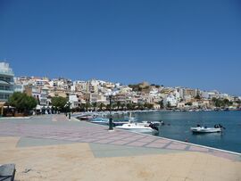
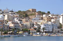
سيتيا (باليونانية: Σητεία) هي ميناء وبلدية في لاسيثي، كريت في اليونان. يبلغ عدد سكانها حوالي 9,912 نسمة (في 2011).
التاريخ

يعود استيطان البلدة إلى ما قبل العصر المينوي. كشفت الحفريات في حي پتراس عن آثار معمارية من نهاية العصر الحجري الحديث (3000 ق.م.) ووتواصل طيلة العصر البرونزي 3000-1050 ق.م.، بما في ذلك القصر المينوي في پتراس. Several other Minoan settlements have been found within the municipality, notably Itanos and Mochlos.
According to Diogenes Laërtius, Sitia was the home of Myson of Chen, one of the Seven Sages of Greece.
أصل الاسم
The ancient Ἠτεία, written as Itia or Etea in English,[2] appears to correspond roughly to modern Sitia. The name Sitia itself is probably the result of rebracketing of the prefix "s-" < σε 'at' + Ἠτεία.[3][4]
سيتيا القديمة
Sitia was founded by Minoans as Iteia, and was a centre of refuge for native Cretans after the fall of the major Minoan settlements. The city continued to prosper through the Classical, Hellenistic, Roman and Byzantine periods as one of the island's chief ports.
العصر البندقي
The town was later expanded and fortified by the Venetians after their acquisition of Crete in 1204, who used it as a base of operations for the Eastern Mediterranean. During the Venetian occupation, the town was destroyed three times: first by an earthquake in 1508, then by the Turkish pirate Hayreddin Barbarossa in 1538, and finally by the Venetians themselves in 1651. This final destruction took place in the context of the Cretan War (1645–1669) in which the Venetians battled to retain their hold on the island against the Ottoman Empire. While Sitia did not fall in the initial Turkish advance the Venetians did not have the resources to withstand a long siege, and accordingly destroyed the fortifications and removed the garrison to Heraklion. The local inhabitants meanwhile removed westwards to Liopetro and the site was subsequently abandoned for the next 200 years of Turkish rule.
The main remnant of the Venetian occupation is the Kazarma (from Italian casa di arma), the old fortress overlooking the harbour.
العصر الحديث
After the Venetian period and subsequent abandonment the town was rebuilt until 1870 by the progressive Turkish governor حسين عوني پاشا following the Cretan Revolt. It was subsequently created عاصمة سنجق لاسيت (لاحقاً Lasithi, which it remains to this day). Under Turkish rule the town was renamed Avniye in honour of its rebuilder, but as the local Greeks continued to use the traditional named of Sitia this innovation did not survive Independence. Despite the turbulent history of Crete in leaving the Ottoman Empire and joining Greece, as well as the First World War, the population almost quadrupled between 1881 (570 inhabitants) and 1928 (2,100 inhabitants). Major public works were carried out by the Greek government in 1911 to modernise the town, in the course of which much of the Ottoman era town was rebuilt, as well as a fresh water supply.
الجغرافيا
المناخ
| بيانات المناخ لـ سيتيا (1960–2010) | |||||||||||||
|---|---|---|---|---|---|---|---|---|---|---|---|---|---|
| الشهر | ينا | فب | مار | أبر | ماي | يون | يول | أغس | سبت | أكت | نوف | ديس | السنة |
| متوسط القصوى اليومية °س (°ف) | 15.2 (59.4) |
15.3 (59.5) |
16.9 (62.4) |
19.9 (67.8) |
23.5 (74.3) |
27.1 (80.8) |
28.4 (83.1) |
28.4 (83.1) |
26.5 (79.7) |
23.5 (74.3) |
20.1 (68.2) |
16.9 (62.4) |
21.8 (71.2) |
| المتوسط اليومي °س (°ف) | 12.2 (54.0) |
12.2 (54.0) |
13.7 (56.7) |
16.6 (61.9) |
20.3 (68.5) |
24.1 (75.4) |
25.9 (78.6) |
25.8 (78.4) |
23.6 (74.5) |
20.3 (68.5) |
16.9 (62.4) |
13.9 (57.0) |
18.8 (65.8) |
| متوسط الدنيا اليومية °س (°ف) | 9.7 (49.5) |
9.5 (49.1) |
10.5 (50.9) |
12.8 (55.0) |
15.9 (60.6) |
19.9 (67.8) |
22.6 (72.7) |
22.7 (72.9) |
20.4 (68.7) |
17.3 (63.1) |
14.0 (57.2) |
11.4 (52.5) |
15.6 (60.1) |
| متوسط تساقط الأمطار mm (inches) | 92.6 (3.65) |
71.0 (2.80) |
49.0 (1.93) |
23.3 (0.92) |
12.1 (0.48) |
2.2 (0.09) |
0.2 (0.01) |
0.8 (0.03) |
16.2 (0.64) |
50.2 (1.98) |
59.5 (2.34) |
91.8 (3.61) |
468.9 (18.46) |
| Average precipitation days | 13.1 | 11.3 | 8.8 | 5.0 | 3.0 | 0.8 | 0.1 | 0.3 | 1.7 | 5.7 | 8.2 | 12.4 | 70.4 |
| Source: Hellenic National Meteorological Service[5] | |||||||||||||
الثقافة
المعالم
- Moni Toplou, founded in the mid 15th century, is one of the most significant monasteries in Crete.
- Kazarma fortress, in the town of Sitia.
- Gorge of the Dead (at Kato Zakros).
- Various archeological sites with Minoan civilization settlements from the Bronze Age, such as in Itanos and Mochlos.
أشخاص بارزون
- Yannis Hamilakis - archaeologist
- Myson - philosopher (one of the 7 legendary wise men of ancient Greece)
- Vitsentzos Kornaros - poet (composer of Erotokritos)
- Giorgos Mazonakis - singer
- Jenny Hiloudaki - DJ
- Manousos - Musician (basist of Psofioi Korioi Band)
المراجع
- ^ أ ب "Απογραφή Πληθυσμού - Κατοικιών 2011. ΜΟΝΙΜΟΣ Πληθυσμός" (in اليونانية). Hellenic Statistical Authority.
- ^ John Freely, Crete: Discovering the 'Great Island ISBN 1-84511-692-5, p. 154
- ^ Thomas Abel Brimage Spratt, Travels and Researches in Crete, 1865, chapter XIX, p. 201
- ^ Bourne, Edward G. (1887). "The Derivation of Stamboul". American Journal of Philology. The Johns Hopkins University Press. 8 (1): 78–82. doi:10.2307/287478. JSTOR 287478.
- ^ "Sitia Climatological data 1960–2010". Hellenic National Meteorological Service. Retrieved 30 September 2020.
وصلات خارجية
 سيتيا travel guide from Wikivoyage
- Municipality of Sitia (History)
- Vai forest
- Richtis gorge
- Gorge of the Dead
- Richtis beach and gorge
- Richtis gorge and waterfall
- 1st General Lyceum of Sitia (high school)
- Cretan Quality Agreement, local non-profit "promoting local cuisine and good health"
- Photos from Sitia
- [1]


