دائرة دوِنتزا
دائرة دوِنتزا
Douentza Cercle | |
|---|---|
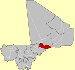
 موقع دائرة دوِنتزا في مالي. | |
| الإحداثيات: 15°05′N 2°40′W / 15.083°N 2.667°W | |
| البلد | |
| المنطقة | موپتي |
| Admin HQ (chef-lieu) | Douentza |
| المساحة | |
| • الإجمالي | 23٬481 كم² (9٬066 ميل²) |
| التعداد (تعداد 2009)[2] | |
| • الإجمالي | 247٬794 |
| • الكثافة | 11/km2 (27/sq mi) |
| منطقة التوقيت | UTC+0 (GMT) |
دائرة دوِنتزا، هو تقسيم اداري في منطقة موپتي، مالي. مركز التقسيم الاداري هو بلدة دوِنتزا.
أثناء تمرد الطوارق 2012، كانت دائرة دوِنتزا هي المنطقة الواقعة في أقصى جنوب دولة أزواد، تبعاً للمطالب الاقليمية للجبهة الوطنية لتحرير أزواد. من يونيو 2012 طالب بها سلسلة من المليشيات الإسلامية والمحلية المتنافسة.
يمر المسار الدوري السنوي لأفيال الگورما عبر عدد من كميونات دائرتي دوِنتزا وگورما-راوس (منطقة تمبكتو).[3][4][5]
التقسيمات الادارية
تنقسم الدائرة إلى 15 كميون:[6]
تمرد الطوارق
في 20 أبريل 2019، مقتل جندي مصري مشارك في قافلة لقوات الأمم المتحدة في مالي، في هجوم للمتمردين. الحادث وقع في دائرة دوِنتزا، بمنطقة موپتي بوسط مالي. منذ تشكيل القوة في 2013 سقط 139 قتيل منها، أمام التمرد الزاحف جنوباً من الانفصاليين الطوارق وتنظيم القاعدة.[7]
المصادر
- ^ (in French)Synthèsis des Plans de Securité Alimentaire des Communes du Cercle de Douentza 2006-2010, Commissariat à la Sécurité Alimentaire, République du Mali, USAID-Mali, 2006, http://www.aec.msu.edu/fs2/mali_fd_strtgy/plans/mopti/douentza/psa_synthese_dtza.pdf.
- ^ (in الفرنسية)Resultats Provisoires RGPH 2009 (Région de Mopti), République de Mali: Institut National de la Statistique, Archived from the original on 2012-09-19, https://www.webcitation.org/6AnaIKCNv?url=http://instat.gov.ml/documentation/mopti.pdf
- ^ Community engagement at Lake Banzena, Wild Foundation, 2011, http://www.slideshare.net/wildfoundation/community-process-may11, retrieved on 7 May 2012.
- ^ Blake, S.; Bouché, P.; Rasmussen, H.; Orlando, A.; Douglas-Hamilton, I. (2003), The Last Sahelian Elephants: Ranging Behavior, Population Status and Recent History of the Desert Elephants of Mali, Save the Elephants, Archived from the original on 2012-05-11, https://web.archive.org/web/20120511044612/http://www.savetheelephants.org/files/pdf/publications/2003%20Blake%20et%20al%20%20The%20last%20Sahelian%20elephants.pdf.
- ^ Canney, S.; Lindsey, K.; Hema, E.; Douglas-Hamilton, I.; Martin, V. (2007), The Mali elephant initiative: synthesis of knowledge, research and recommendations about the population, its range and the threats to the elephants of the Gourma, Save the Elephants, Archived from the original on 2012-05-11, https://web.archive.org/web/20120511045808/http://www.savetheelephants.org/files/pdf/publications/2007%20The%20WILD%20Foundation%20et%20al%20The%20Mali%20elephant%20initiative%20synthesis%20of%20knowledge.pdf.
- ^ (in French)Loi N°99-035/ du 10 Aout 1999 Portant Création des Collectivités Territoriales de Cercles et de Régions, Ministère de l'Administration Territoriales et des Collectivités Locales, République du Mali, 1999, Archived from the original on 2012-03-09, https://web.archive.org/web/20120309073942/http://www.matcl.gov.ml/PDF/LoiCreationCercleReg.pdf.
- ^ AP (2019-04-20). "UN says attack in central Mali kills peacekeeper from Egypt". أسوشييتد پرس.
الكلمات الدالة:
This article contains content from Wikimedia licensed under CC BY-SA 4.0. Please comply with the license terms.


