الريڤييرا الفرنسية
French Riviera
| |
|---|---|
 .jpg&filetimestamp=20220928211833&) .jpg&filetimestamp=20220928211825&)  From top down, left to right: a view of Èze with Saint-Jean-Cap-Ferrat in the background, city centre of Nice, old town of Saint-Tropez, Monte Carlo Casino in the Principality of Monaco | |
 | |
| Country | |
| الموقع الإلكتروني | cotedazurfrance |
الريڤييرا الفرنسية أو كوت دازور Cote d'Azur النهاية الشرقية لساحل البحر المتوسط في فرنسا. وتشمل هذه المنطقة جزءًا من الريفييرا الفرنسية، وهي منتجع مشهور لقضاء العطلات. ويعني الاسم الفرنسي كوت دازور ساحل اللازورد، وقد أطلق الاسم على المنطقة بسبب الزرقة الجميلة للبحر والسماء. وتمتد على الشاطئ بساتين النخيل وأشجار البرتقال، وحدائق الأزهار الاستوائية المتألقة. وهذا الجزء منطقة للترويح يؤمها السياح من جميع أنحاء العالم.
There is no official boundary, but it is usually considered to extend from Toulon, Le Lavandou or Saint-Tropez in the west to Menton at the France–Italy border in the east.[1][2] The coast is entirely within the Provence-Alpes-Côte d'Azur region of France. The Principality of Monaco is a semi-enclave within the region, surrounded on three sides by France and fronting the Mediterranean. The French Riviera contains the seaside resorts of Cap-d'Ail, Beaulieu-sur-Mer, Saint-Jean-Cap-Ferrat, Villefranche-sur-Mer, Antibes, Juan-les-Pins, Cannes, Saint-Raphaël, Fréjus, Sainte-Maxime and Saint-Tropez.[3]
Riviera is an Italian word that originates from the ancient Ligurian territory of Italy, wedged between the Var and Magra rivers. The Côte d'Azur (coast of azure) is a nickname given by France to the County of Nice after its annexation in 1860, because the climate was similar to that of the north of Italy, even in winter, with a sky as blue as its sea. When the Mistral (northwest) and the Tramontane (north) winds are blowing in the Languedoc and Provence areas, the temperature of the Mediterranean can be very cool in summer. This phenomenon is observed very little or not at all on the coast between the French Riviera and the Italian Riviera.[4]
After the 2000s, the French Riviera was extended to the rest of Southern France, although the geography, culture, and climate are different.
This coastline was one of the first modern resort areas. It began as a winter health resort for the British upper class at the end of the 18th century. With the arrival of the railway in the mid-19th century, it became the playground and vacation spot of British, Russian, and other aristocrats, such as Queen Victoria, Tsar Alexander II and King Edward VII, when he was Prince of Wales. In the summer, it also played home to many members of the Rothschild family. In the first half of the 20th century, it was frequented by artists and writers, including Pablo Picasso, Henri Matisse, Francis Bacon,[5] Edith Wharton, Somerset Maugham and Aldous Huxley, as well as wealthy Americans and Europeans. After World War II, it became a popular tourist destination and convention site. Many celebrities, such as Elton John and Brigitte Bardot, have homes in the region.
Officially, the French Riviera is home to 163 nationalities with 83,962 foreign residents,[6] although estimates of the number of non-French nationals living in the area are often much higher.[7] Its largest city is Nice, which has a population of 340,017 as of 2017.[8] The city is the centre of a métropole—Nice-Côte d'Azur—bringing together 49 communes and more than 540,000 inhabitants and 943,000 in the urban area. Nice is home to Nice Côte d'Azur Airport, France's third-busiest airport (after Charles de Gaulle Airport and Orly Airport), which is on an area of partially reclaimed coastal land at the western end of the Promenade des Anglais. A second airport at Mandelieu was once the region's commercial airport,[9] but is now mainly used by private and business aircraft.[10]
The A8 autoroute runs through the region, as does the old main road generally known as the Route nationale 7 (officially now DN7 in Var and D6007 in Alpes-Maritimes).[11] High-speed trains serve the coastal region and inland to Grasse, with the TGV Sud-Est service reaching Nice-Ville station in five and a half hours from Paris. The French Riviera has a total population of more than two million. It is home to a high tech and science park (French: technopole) at Sophia-Antipolis (north of Antibes) and a research and technology centre at the University of Nice Sophia Antipolis. The region has 35,000 students, of whom 25 percent are working toward a doctorate.[12] The French Riviera is a major yachting and cruising area with several marinas along its coast. According to the Côte d'Azur Economic Development Agency, each year the Riviera hosts 50 percent of the world's superyacht fleet, with 90 percent of all superyachts visiting the region's coast at least once in their lifetime.[13] As a tourist centre, the French Riviera benefits from 310 to 330 days of sunshine per year, 115 كيلومتر (71 ميل) of coastline and beaches, 18 golf courses, 14 ski resorts and 3,000 restaurants.[14]
وتشمل المدن الرئيسية في هذه المنطقة أنتيب، وكان، ونيس في فرنسا، ومونت كارلو في موناكو.
التسمية
أصول الاسم

The term French Riviera comes by analogy with the term Italian Riviera, which extends east of the French Riviera (from Ventimiglia to La Spezia).[15] As early as the 19th century, the British referred to the region as the Riviera or the French Riviera, usually referring to the eastern part of the coast, between Monaco and the Italian border.[16] Originally, riviera is an Italian noun which means "coastline".[17]
The name Côte d'Azur was given to the coast by the writer Stéphen Liégeard in his book, La Côte d’azur, published in December 1887.[18] Liégeard was born in Dijon, in the French department of Côte-d'Or, and adapted that name by substituting the azure colour of the Mediterranean for the gold of Côte-d'Or.[19]
In Occitan (Niçard and Provençal) and French, the only usual names are Còsta d'Azur in Occitan and Côte d'Azur in French.[20] A term like "French Riviera" (Ribiera Francesa in Occitan, Riviera Française in French) would only be used in literal translation, or adaptations of it. For instance, in French, "Riviera Française" is found in the online Larousse encyclopedia[21] to refer to the holidays of a group of English workers (moreover, in Occitan, the word ribiera "coastline" mostly works as a common name, whereas in French, the old-fashioned term Rivière de Gênes was used to refer to the Italian Riviera whose center is Genoa).[22]
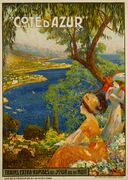
Poster by David Dellepiane (1866–1932)
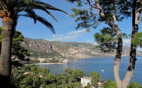
The French riviera between Beaulieu-sur-Mer and Cap-d'Ail, as seen from Saint-Jean-Cap-Ferrat
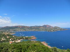
Agay, a seaside resort in Saint-Raphaël
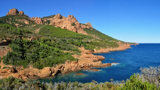
Cap-Roux and the Corniche d'Or in the calanque of Anthéor, Massif de l'Esterel


Disputes over the extent of the Riviera and the Côte d'Azur

Côte d'Azur and the French Riviera have no official boundaries. Some sources put the western boundary at Saint-Tropez. Others include Saint Tropez, Hyères or Toulon in the Var (departement), or as far as Cassis in the Bouches-du-Rhône departement.[1][2] In her 1955 novel, The Talented Mr. Ripley, Patricia Highsmith describes the Riviera as including all of the coast between Toulon and the Italian border.
التاريخ
من قبل التاريخ إلى العصر البرونزي
The region of the French Riviera has been inhabited since prehistoric times. Primitive tools dating to between 1,000,000 and 1,050,000 years ago were discovered in the Grotte du Vallonnet, near Roquebrune-Cap-Martin, with stones and bones of animals, including bovines, rhinoceros, and bison. At Terra Amata (380,000 to 230,000 years ago), near the Nice Port, a fireplace was discovered that is one of the oldest found in Europe.[23]
Stone dolmens, monuments from the Bronze Age, can be found near Draguignan, while the Valley of Marvels (Vallée des Merveilles) near Mount Bégo, at 2،000 m (6،600 ft) elevation, is presumed to have been an outdoor religious sanctuary, having over 40,000 drawings of people and animals, dated to about 2000 BC.[24]
النفوذ اليوناني
Beginning in the 7th century BC, Greek sailors from Phocaea in Asia Minor began to visit and then build emporia along the Côte d'Azur. Emporia were started at Olbia (Hyères); Antipolis (Antibes) and Nikaia (Nice). These settlements, which traded with the inhabitants of the interior, became rivals of the Etruscans and Phoenicians, who also visited the Côte d'Azur.
الاستعمار الروماني
In 8 BC the Emperor Augustus built an imposing trophy monument at La Turbie (the Trophy of the Alps or Trophy of Augustus) to mark the pacification of the region.
Roman towns, monuments and amphitheatres were built along the Côte d'Azur and many still survive, such as the amphitheatre and baths at Cimiez, above Nice, and the amphitheatre, Roman walls and other remains at Fréjus.

البرابرة والمسيحيون
Roman Provence reached the height of its power and prosperity during the 2nd and 3rd centuries AD. In the mid-3rd century, Germanic peoples began to invade the region, and Roman power weakened.
In the same period, Christianity started to become a powerful force in the region. The first cathedrals were built in the 4th century, and bishoprics were established: in Fréjus at the end of the 4th century, Cimiez and Vence in 439, and Antibes in 442. The oldest Christian structure still in existence on the Côte d'Azur is the baptistery of Fréjus Cathedral, built at the end of the 5th century, which also saw the founding of the first monastery in the region, Lerins Monastery on an island off the coast at Cannes.
The fall of the Western Roman Empire in the first half of the 5th century was followed by invasions of Provence by the Visigoths, the Burgundians and the Ostrogoths. There was then a long period of wars and dynastic quarrels, which in turn led to further invasions by the Saracens and the Normans in the 9th century.
كونتات پروڤانس وبيت گريمالدي

جاذبيته لدى الطبقة العليا البريطانية في القرنين 18 و 19


فترة ما بعد الحرب وأواخر القرن العشرين

الجغرافيا


بلديات ساحلية
| Municipality | Inhabitants (1 January 2018) |
Département |
|---|---|---|
| Cassis | 7,027 | Bouches-du-Rhône |
| La Ciotat | 35,281 | Bouches-du-Rhône |
| Saint-Cyr-sur-Mer | 11,580 | Var |
| Bandol | 8,404 | Var |
| Sanary-sur-Mer | 16,696 | Var |
| Six-Fours-les-Plages | 33,665 | Var |
| Saint-Mandrier-sur-Mer | 5,979 | Var |
| La Seyne-sur-Mer | 62,888 | Var |
| Ollioules | 13,771 | Var |
| Toulon | 176,198 | Var |
| La Garde | 25,380 | Var |
| Le Pradet | 10,265 | Var |
| Carqueiranne | 9,555 | Var |
| Hyères | 55,069 | Var |
| La Londe-les-Maures | 10,389 | Var |
| Bormes-les-Mimosas | 8,223 | Var |
| Le Lavandou | 5,981 | Var |
| Rayol-Canadel-sur-Mer | 689 | Var |
| Cavalaire-sur-Mer | 7,499 | Var |
| La Croix-Valmer | 3,778 | Var |
| Ramatuelle | 2,079 | Var |
| Saint-Tropez | 4,103 | Var |
| Gassin | 2,586 | Var |
| Cogolin | 11,556 | Var |
| Grimaud | 4,553 | Var |
| Fréjus | 53,786 | Var |
| Sainte-Maxime | 14,240 | Var |
| Roquebrune-sur-Argens | 14,626 | Var |
| Saint-Raphaël | 35,633 | Var |
| Théoule-sur-Mer | 1,350 | Alpes-Maritimes |
| Mandelieu-la-Napoule | 21,836 | Alpes-Maritimes |
| Cannes | 73,965 | Alpes-Maritimes |
| Vallauris | 27,072 | Alpes-Maritimes |
| Antibes | 72,915 | Alpes-Maritimes |
| Villeneuve-Loubet | 15,780 | Alpes-Maritimes |
| Cagnes-sur-Mer | 51,411 | Alpes-Maritimes |
| Saint-Laurent-du-Var | 28,511 | Alpes-Maritimes |
| Nice | 341,032 | Alpes-Maritimes |
| Saint-Jean-Cap-Ferrat | 1,533 | Alpes-Maritimes |
| Beaulieu-sur-Mer | 3,731 | Alpes-Maritimes |
| Villefranche-sur-Mer | 5,064 | Alpes-Maritimes |
| Èze | 2,225 | Alpes-Maritimes |
| Cap-d’Ail | 4,529 | Alpes-Maritimes |
| Monaco | 38,100 | — |
| Roquebrune-Cap-Martin | 12,824 | Alpes-Maritimes |
| Menton | 30,231 | Alpes-Maritimes |
| Total (46) | 1,383,588 | — |
أماكن
Places on the Côte d'Azur (following the broadest definition), following the coast from south-west to north-east, include:
- Cassis
- La Ciotat
- Bandol
- Sanary-sur-Mer
- Six-Fours-les-Plages
- La Seyne-sur-Mer
- Toulon
- Hyères and the Îles d'Hyères (Porquerolles, Port-Cros and Île du Levant)
- Le Lavandou
- Cavalaire-sur-Mer
- Saint-Tropez
- Inland – Grimaud, with Port-Grimaud on the coast
- Sainte-Maxime
- Roquebrune-sur-Argens
- Fréjus and Saint-Raphaël
- Inland – Fayence
- Les Adrets-de-l'Estérel
- Tanneron
- Théoule-sur-Mer
- Mandelieu-la-Napoule
- Inland – Grasse
- Inland – Mougins
- the Îles de Lérins – Île Sainte-Marguerite and Île Saint-Honorat
- Cannes
- Inland – Vallauris
- Inland – Valbonne
- Inland – Sophia-Antipolis
- Golfe-Juan
- Juan-les-Pins
- Antibes
- Inland – Biot
- Villeneuve-Loubet
- Cagnes-sur-Mer
- Inland – Vence
- Inland – Saint-Paul-de-Vence
- Inland – Saint-Jeannet
- Saint-Laurent-du-Var
- Inland – Belvédère
- نيس
- Villefranche-sur-Mer
- Saint-Jean-Cap-Ferrat
- Beaulieu-sur-Mer
- Èze
- Cap d'Ail
- Monaco (including Monte-Carlo)
- Beausoleil
- Roquebrune-Cap-Martin
- Menton
السياحة
Some data related to tourism on the Riviera in 2006:
- More than 14 million tourists
- 52% of customers from abroad
- 65 million nights stayed
- Tourists spending €5 billion
- 75,000 jobs; tourism is 18% of total employment in the Alpes-Maritimes.
- 500,000 tourists in the High Country
- 500,000 delegates
- 3 million admissions to museums and monuments
- More than 45% of tourists come by air
المناخ
| بيانات المناخ لـ Nice (1981–2010 averages) | |||||||||||||
|---|---|---|---|---|---|---|---|---|---|---|---|---|---|
| الشهر | ينا | فب | مار | أبر | ماي | يون | يول | أغس | سبت | أكت | نوف | ديس | السنة |
| القصوى القياسية °س (°ف) | 22.5 (72.5) |
25.8 (78.4) |
26.1 (79.0) |
26.0 (78.8) |
30.3 (86.5) |
36.8 (98.2) |
36.3 (97.3) |
37.7 (99.9) |
33.9 (93.0) |
29.9 (85.8) |
25.4 (77.7) |
22.0 (71.6) |
37.7 (99.9) |
| متوسط القصوى اليومية °س (°ف) | 13.1 (55.6) |
13.4 (56.1) |
15.2 (59.4) |
17 (63) |
20.7 (69.3) |
24.3 (75.7) |
27.3 (81.1) |
27.7 (81.9) |
24.6 (76.3) |
21.0 (69.8) |
16.6 (61.9) |
13.8 (56.8) |
19.6 (67.2) |
| متوسط الدنيا اليومية °س (°ف) | 5.3 (41.5) |
5.9 (42.6) |
7.9 (46.2) |
10.2 (50.4) |
14.1 (57.4) |
17.5 (63.5) |
20.3 (68.5) |
20.5 (68.9) |
17.3 (63.1) |
13.7 (56.7) |
9.2 (48.6) |
6.3 (43.3) |
12.4 (54.2) |
| الصغرى القياسية °س (°ف) | −7.2 (19.0) |
−5.8 (21.6) |
−5.0 (23.0) |
2.9 (37.2) |
3.7 (38.7) |
8.1 (46.6) |
11.7 (53.1) |
11.4 (52.5) |
7.6 (45.7) |
4.2 (39.6) |
0.1 (32.2) |
−2.7 (27.1) |
−7.2 (19.0) |
| متوسط تساقط الأمطار mm (inches) | 69.0 (2.72) |
44.7 (1.76) |
38.7 (1.52) |
69.3 (2.73) |
44.6 (1.76) |
34.3 (1.35) |
12.1 (0.48) |
17.8 (0.70) |
73.1 (2.88) |
132.8 (5.23) |
103.9 (4.09) |
92.7 (3.65) |
733 (28.87) |
| Average precipitation days | 6 | 5 | 5 | 7 | 5 | 4 | 2 | 2 | 5 | 7 | 7 | 6 | 61 |
| Mean monthly ساعات سطوع الشمس | 158 | 171 | 217 | 224 | 267 | 306 | 348 | 316 | 242 | 187 | 149 | 139 | 2٬724 |
| نسبة السطوع المحتمل للشمس | 54 | 58 | 59 | 56 | 58 | 66 | 74 | 73 | 65 | 55 | 51 | 50 | 60 |
| Source: [25] | |||||||||||||

أحداث ومهرجانات
Several major events take place:
- Monaco and southeast France; Rallye Automobile Monte-Carlo, January
- Monaco; International Circus Festival of Monte-Carlo, January / February
- Nice; Carnival, February
- Menton; Lemon Festival, February
- Tourrettes-sur-Loup; Violet Festival, March
- Monaco; Formula One Grand Prix race, May
- Grasse; Rose Festival, May
- Cannes; Cannes Film Festival and Cannes Film Market, May
- Nice; Jazz Festival, July
- Juan-les-Pins; Jazz à Juan, late July.
- Grasse; Jasmine Festival, August
رسامون

The climate and vivid colours of the Mediterranean attracted many famous artists during the 19th and 20th centuries. They included:
- Pierre Bonnard (1867-1947); retired to and died at Le Cannet.
- Georges Braque (1882-1963); painted frequently at L'Estaque between 1907 and 1910.
- Roger Broders (1883-1953); Parisian travel poster illustrator.
- Paul Cézanne (1839-1906); a native of Aix-en-Provence, Cézanne painted at L'Estaque between 1878 and 1882.
- Henri-Edmond Cross (1856-1910); discovered the Côte d'Azur in 1883, and painted at Monaco and Hyères.
- Maurice Denis (1870-1943); painted at St. Tropez and Bandol.
- André Derain (1880-1954); painted at L'Estaque and Martigues.
- Raoul Dufy (1877-1953); whose wife was from Nice, painted in the region, including in Nice, Marseille and Martigues.
- Albert Marquet (1873-1947); painted at Marseille, St. Tropez and L'Estaque.
- Henri Matisse (1869-1954); first visited St. Tropez in 1904. In 1917 he settled in Nice, first at the Hôtel Beau Rivage, then at the Hôtel de la Méditerranée, then at la Villa des Alliés in Cimiez. In 1921 he lived in an apartment in Nice, next to the flower market and overlooking the sea, where he lived until 1938. He then moved to the Hôtel Régina in the hills of Cimiez, above Nice. During World War II he lived in Vence, then returned to Cimiez, where he died and is buried.
- Claude Monet (1840-1927); visited Menton, Bordighera, Juan-les-Pins, Monte Carlo, Nice, Cannes, Beaulieu and Villefranche, and painted a number of seascapes of Cap Martin, near Menton, and at Cap d'Antibes.
- Edvard Munch (1863-1944); visited and painted in Nice and Monte Carlo (where he developed a passion for gambling), and rented a villa at Saint-Jean-Cap-Ferrat in 1891.
- Pablo Picasso (1881-1973); spent each summer from 1919 to 1939 on the Côte d'Azur, and moved there permanently in 1946, first at Vallauris, then at Mougins, where he spent his last years.
- Auguste Renoir (1841-1919); visited Beaulieu, Grasse, Saint-Raphaël and Cannes, before finally settling in Cagnes-sur-Mer in 1907, where he bought a farm in the hills and built a new house and workshop on the grounds. He continued to paint there until his death in 1919. His house is now a museum.
- Paul Signac (1863-1935); visited St. Tropez in 1892, and bought a villa, La Hune, at the foot of citadel in 1897. It was at his villa that his friend, Henri Matisse, painted his famous Luxe, Calme et Volupté in 1904. Signac made numerous paintings along the coast.
انظر أيضا
- الريڤييرا الايطالية
- Gardens of Provence-Alpes-Côte d'Azur
- Gulf of Genoa
- Provence-Alpes-Côte d'Azur
- The article Riviera provides links to articles on the many coastal strips around the world which are known as Riviera
ببليوگرافيا
التاريخ
- Aldo Bastié, Histoire de la Provence, Éditions Ouest-France, 2001.
- Mary Blume, Côte d'Azur: Inventing the French Riviera, Thames and Hudson, London, 1992.
- Patrick Howarth, When the Riviera was Ours, Routledge & Kegan Paul, London, 1977.
- Jim Ring, Riviera, the Rise and Fall of the Côte d'Azur, John Murray Publishers, London, 1988.
رسامون
- La Méditerranée de Courbet à Matisse, catalog of the exhibit at the Grand Palais, Paris from September 2000 to January 2001. Published by the Réunion des musées nationaux, 2000.
المصادر
- ^ أ ب "Côte d'Azur, côte méditerranéenne française entre Cassis et Menton" ("Côte d'Azur, French Mediterranean coast between Cassis and Toulon") in Dictionnaire Hachette encyclopédique (2000), p. 448.
- ^ أ ب "Côte d'Azur, Partie orientale du littoral français, sur la Méditerranée, de Cassis à Menton" ("Côte d'Azur, Eastern part of the French coast, on the Mediterranean, from Cassis to Menton"), in Le Petit Larousse illustré (2005), p. 1297.
- ^ Jim Ring, Riviera, The Rise and Rise of the Cote d'Azur, John Murray Publishers, London, 2004.
- ^ "Climat : Tropicalisation des nuits azuréennes". www.meteofrance.fr.
- ^ Wrathall, Claire (6 يوليو 2016). "Francis Bacon's Monaco magic is highlighted in a new exhibition". The Telegraph (in الإنجليزية البريطانية). ISSN 0307-1235. Archived from the original on 12 يناير 2022. Retrieved 18 ديسمبر 2018.
- ^ INSEE 1999 census
- ^ e.g. Comité Régional du Tourisme Riviera Côte d'Azur.
- ^ Téléchargement du fichier d'ensemble des populations légales en 2017, INSEE
- ^ Official site: Cannes.aeroport.fr Archived 28 أبريل 2013 at the Wayback Machine
- ^ Official site: Cannes.aeroport.fr Archived 18 مايو 2009 at the Wayback Machine
- ^ National 7 website: Nationale7.com
- ^ Sirius CCINCA.
- ^ Côte d'Azur Economic Development Agency – p.31 CRDP-Nice.net Archived 4 يوليو 2010 at the Wayback Machine
- ^ Côte d'Azur Economic Development Agency, op.cit. p.66
- ^ In English, "Riviera" as a whole is defined as "the coastal strip along the Mediterranean from La Spezia, Italy, to west of Cannes, France". Webster's New World Dictionary of American English, Third College Edition, 1988.
- ^ For example, J. Henry Bennett, Mentone, the Riviera, Corsica and Biarritz as Winter Climates (1862)
- ^ "Vocabolario: Riviera". Enciclopedia Italiana di Scienze, Lettere ed Arti. Istituzionali della Treccani.
- ^ msaldo; admin; yvasovic; yvasovic (23 أبريل 2018). "Cannes Avance - Mini Une fixe - Accueil". www.cannes.com.
- ^ Marc Boyer, L'Invention de la Côte d'Azur : l'hiver dans le Midi, préface de Maurice Agulhon, 378 pages, Édition de l'Aube, 2002, ISBN 2-87678-643-5.
- ^ Larousse, Éditions. "Encyclopédie Larousse en ligne - Côte d'Azur". www.larousse.fr.
- ^ Larousse, Éditions. "Encyclopédie Larousse en ligne - Vacances d'été Summer Holiday". www.larousse.fr.
- ^ Harrap's Standard French and English Dictionary, 1948.
- ^ Henry de Lumley, La Grande Histoire des premiers hommes europeens, p. 120.
- ^ Aldo Bastié, Histoire de la Provence, Edition Ouest-France, 2001.
- ^ "1981–2010 Data". يوليو 2012.
وصلات خارجية
- (إنگليزية) Wikitravel
- CS1 الإنجليزية البريطانية-language sources (en-gb)
- Pages using gadget WikiMiniAtlas
- Short description is different from Wikidata
- Articles with hatnote templates targeting a nonexistent page
- Missing redirects
- Use dmy dates from August 2020
- Articles containing فرنسية-language text
- Articles containing أوكسيتان (بعد 1500)-language text
- Pages using infobox settlement with no coordinates
- Coordinates on Wikidata
- الريڤييرا الفرنسية
- منتجعات بحرية في فرنسا
- سواحل فرنسا
- تضاريس پروڤنس-ألپ-كوت دازور
- البحر الليگوري