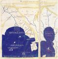
البنغال
البنغال
Bengal
| |
|---|---|
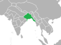
منطقة في آسيا | |
 موقع البنغال | |
 Interactive map of البنغال Bengal | |
| القارة | آسيا |
| البلدان | |
| الهند في العصر الحجري، الهند الڤدكية، مملكة الڤانگا | 1500 – ح. 500 ق.م. |
| گانگاريداي، امبراطورية ناندا | 345–300 ق.م. |
| امبراطورية گوپتا | القرن 2- القرن 5 |
| امبراطورية پالا | القرن 8 - القرن 12 |
| سلطنة دلهي | 1204–1339 ق.م. |
| سلطنة البنغال | 1338–1576 ق.م. |
| البنغال صباح | 1565–1717 ق.م. |
| نواب البنغال | 1717–1765 ق.م. |
| رئاسة البنغال | 1765–1947 ق.م. |
| المدن الرئيسية | |
| Area | |
• Total | 236٬322 كم² (91٬244 ميل²) |
| Population (2011) | |
• Total | 250 million ~ 300 مليون |
| • Density | 1٬070/km2 (2٬800/sq mi) |
| Demonym | بنغالي |
| اللغات الرسمية | بنگلادش – البنغالية[1] البنغال الغربية – البنغالية، الإنگليزية[2] |
| جزء من سلسلة عن |
| البنغاليون |
|---|
_(1438844597).jpg&filetimestamp=20170519232948&) |
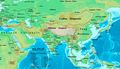
البنغال (/bɛŋˈɡɔːl/;[3] بالبنغالية: বাংলা/বঙ্গ تُنطق بالبنغالية: [bɔŋgo])، هي منطقة جيوسياسية وثقافية وتاريخية في جنوب آسيا، وخاصة المنطقة الشرقية من شبه القارة الهندية على رأس خليج البنغال. جغرافياً، تشكلت من منظومة دلتا الگانج-براهماپوترا، أكبر تشكيل من نوعه في العالم؛ بالإضافة للجبال الواقعة شمال البنغال، تحدها بلدان الهيمالايا؛ نيپال وبوتان من الشمال، وبورما من الشرق.
الجغرافيا

تقع معظم منطقة البنغال في دلتا الگانج-براهماپوترا، لكن توجد مرتفعات في شمال المنطقة، وشمالها الشرقي، وجنوبها الشرقي. تتشكل دلتا الگانج من التقاء أنهار الگانج وبراهماپوترا، ومگنا وروافدها. تبلغ إجمالي مساحة البنغال 232.752 كم2—غرب البنغال 88.752 كم2، وبنگلادش 147.570 كم2.
التمايز الجغرافي

شمال البنغال

شمال البنغال هو مصطلح يستخدم للإشارة إلى المنطقة الشمالية الغربية من بنگلادش والمنطقة الشمالية من غرب البنغال. يتألف الجزء البنگلاديشي من تقسيم راجشاهي وتقسيم رانگپور. بصفة عامة، هي منطقة تقع غرب نهر جامونا وشمال نهر پادما، وتتضمن قناة باريند. سياسياً، تتألف منطقة غرب البنغال من تقسيم جالپايگوري (ضلع عليپوردوار، كوچ بهار، دارجيلينگ، جالپايگوري، شمال ديناجپور، جنوب ديناجپور ومالدا معاً وتتضمن مناطق بيهار ضلع كيشانگانج. كما تقع تلال دارجيلينگ في شمال البنغال. على الرغم من أن شعوب جياپايگوري، عليپوردوار وكوچ بيهار هم فقط من يعرفون أنفسهم بأنه بنغاليو الشمال. تنقسم شمال البنغال إلى منطقتي تراي ودوارس. كما تشتهر شمال البنغال بتراثها الغني، وتتضمن منطقتي تراث عالمي. بغض النظر عن الغالبية البنغالية، تضمن شمال البنغال الكثير من الجاليات الأخرى التي تشمل النيپاليين، شعب السانتال، اللـِپاچاس، والراجبونگشيس.
شمال شرق البنغال
.JPG&filetimestamp=20190923164300&)
شمال شرق البنغال [4] هو مصطلح يشير إلى منطقة سيلت، وتتألف من تقسيم سيلت في بنگلادش ووادي باراك في ولاية أسام الهندية. تشتهر المنطقة بأراضيها المرتفعة والخصبة، مزارع الشاي الواسعة والغابات المطيرة والأراضي الرطبة. يميز المنطقة نهري سورما وباراك. مدينة سيلت هي أكبر مراكزها الحضرية، وتشتهر المنطقة بلهجتها المميزة. الاسم القديم للمنطقة هو سريهاتا.[5] كانت المنطقة تحت حكم مملكة كماروپا و[هاريكلا]] بالإضافة إلى سلطنة البنغال. أصبحت لاحقاً منطقة تابعة لسلطنة المغل. بالإضافة للبنغاليين الذين يشكلون غالبية السكان، هناك أعداد أقل من البيشنوپريا مانيپوري، الكاسيا وأقليات قبلية أخرى.[5]
المنطقة هي ملتقى طرق البنغال وشمال شرق الهند.
وسط البنغال
يشير وسط البنغال إلى تقسيم دكا في بنگلادش. ويتضمن قناة مادوپور المرتفعة وغابة أشجار الشورية الشاسعة. يتدفق نهر پدما عبر الجزء الجنوبي من المنطقة، ليفصلها عنه منطقة فريدپور الأكبر. في الشمال تقع منطقتي مايمنسينغ وتانگيل الأكبر.
جنوب البنغال
تغطي جنوب البنغال الجزء الجنوبي لولاية غرب البنغال الغندي وجنوب غرب بنگلادش. يتضمن الجزء الهندي من جنوب البنغال 12 ضلع: كلكتا، هواراه، هوگلي، بوردوان، شرق ميدناپور، غرب ميدناپور، پوروليا، بانكورا، بيربوم، ناديا، جنوب 24 پاراگاناس، شمال 24 پاراگاناس.[6][7][8] أما الجزء البنگلاديشي فيشمل تقسيم فريدپور، تقسيم كولنا، وتقسيم باريسال.[9][نشر ذاتي سطري?][10]
سنداربانس، أكبر نقطة تنوع حيوي، تقع في جنوب البنغال. تضم بنگلادش 60% من الغابة، وتقع بقيتها في الهند.
جنوب شرق البنغال

جنوب شرق البنغال[11][12][13] هو مصطلح يشير إلى المناطق الساحلية المرتفعة الناطقة بالبنغالية في تقسيم تشيتاگونگ في جنوب شرق بنگلادش وولاية تريپورا الهندية. تشتهر جنوب شرق البنغال بتراثها كمنطقة بحرية وبصناعة السفن. في العصر العتيق، كانت المنطقة تحت سيطرة مملكتي هاريكلا وسماتاتا البنغالية. في القرن التاسع، كانت مشهورة بين التجار العرب باسم هرقند.[14] أثناء العصور الوسطى، كانت المنطقة تحت حكم سلطنة البنغال، مملكة تريپورا، مملكة مراوك يو، الامبراطورية الپرتغالية وامبراطورية المغل، قبل أن تخضع للحكم البريطاني. اللهجة التشيتاگونية هي السائدة في المناطق الساحلية لجنوب شرق البنغال. بالإضافة لسكانها البنغاليين، تضم المنطقة أيضاً جماعات عرقية تبتية-بورمية، منها شعوب التشاكما، المارما، التانتشانگيا، التريپوري والباوم.
النبيت والوحيش

التاريخ
 |
Gangaridai Kingdom, مملكة ڤانگا, Pundra Kingdom, مملكة سوهما، مملكة أنگا، مملكة هاريكلا |
امبراطورية پالا امبراطورية سنا |
سلطنة البنغال مملكة دڤا بختيار خلجي، راجا گانشا |
Pratap Aditya, Raja Sitaram Ray نواب البنغال ومرشد آباد بارو-بهويان |
النظام الزامنداري، مجاعة البنغال 1770 |
نهضة البنغال براهمو سماج سوامي ڤيڤكانندا، جاگديش چاندرا بوزه، رابندراناث طاغور، سوبهاس چاندرا بوزه |
تقسيم البنغال 1947، حرب تحرير بنگلادش الشيخ مجيب الرحمن، جيوتي باسو |
ما قبل التاريخ
قد يرجع وجود الاستيطان البشري في البنغال إلى 20.000 سنة مضت.[citation needed] تعود بقايا مستوطنات العصر النحاسي إلى 4.300 سنة.[16][17] تؤكد الأدلة الأثرية أنه بحلول الألفية الثانية قبل الميلاد، كانت هناك تجمعات تزرع الأرزق تستوطن المنطقة. بحلول القرن 11 ق.م، كانت شعوب المنطقة تسكن في بيوت مبنية بطريقة منظمة، تستخدم المقابر البشرية والحلي المصنوعة من النحاس والفخار الأسود والأحمر.[18]
عصر المغل (1576–1757)

العصر الاستعماري (1757–1947)

حصد إعصر بولا 1970 حيادة 500.000 شخص في البنغال، مما يجعله واحداً من أعتى الأعاصير المسجلة.
ما بعد التقسيم (1947–الحاضر)
الهند
- غرب البنغال
أصبحت منطقة غرب البنغال واحدة من أكثر الولايات الهندية اكتظاظاً بالسكان. كلكتا، العاصمة السابقة للراج البريطاني، أصبحت عاصمة ولاية غرب البنغال وظلت أكبر مدينة في الهند حتى أواخر القرن 20، عندما حدث نقص حاد في الطاقة، إضرابات وأضرت إحدى الحركات الناكساليتية-الماركسية العنيفة بمعظم البنية التحتية للولاية في فترة الستينيات والسبعينيات، مما أدى لفترة من الركود الاقتصادي. خضعة سياسات غرب البنغال لتغير كبير عندما فازت جبهة اليسار في انتخابات المجلس لعام 1977، بعد هزيمتها المؤتمر الوطني الهندي الشاغر. جبهة اليسار، بقيادة الحزب الشيوعي الهندي (الماركسي حكم الولاية على مدار أكثر من ثلاثة عقود، التي كانت أطول فترة إدارية شيوعية منتخبة في التاريخ.[19] منذ عقد 2000، شهدت غرب البنغال فترة تجدد اقتصادي، وخاصة في صناعة تكنولوجيا المعلومات.
- تريپورا

ولاية هيل تيپرا الأميرية، التي كانت تحت سيادة الهند البريطانية، كانت تحت حكم الملكية الناطقة بالبنغالية. بعد وفاة مهراجا ير بيكرام كيشور دبرامان، تم انضمت الولاية الأميرية إلى اتحاد الهند في 15 أكتوبر 1949 بموجب اتفاقية دمج تريپورا التي وقعها مهاراني كنتشان پراڤا ديڤي. بحلول الخمسينيات، أصبح البنغاليون يشكلون أغلبية سكان المنطقة بسبب تدفق الهندوس من شرق پاكستان بعد التقسيم. أصبحت إقليم اتحادي هندي في نوفمبر 1953. مُنحت الولائية الكاملة مع مجلس تشريعي منتخب في يوليو 1963. أثر تمرد السكان الأصليون على الولاية لعدة سنوات. حكمت جبهة اليسار الولاية بين عام 1978 و1988، ثم عادة للحكم الشيوعي.[20]
- وادي باراك
انضم وادي باراك لاتحاد الهند بعد انفصاله عن سيلت عام 1947 وأصبح جزءاً من ولاية أسام. كانت حركة اللغة البنغالية عام 1961، من أهم الأحداث في تاريخ المنطقة، والتي أدى مقتل قادتها على يد شرطة الولاية إلى الاعتراف باللغة البنغالية كإحدى اللغات الرسمية لولاية أسام. كانت قضية التسوية البنغالية جزءاً من نزاع أسام. قُتل فيها
پنگلادش

East Pakistan (1947–1971)
In 1948, the Government of the Dominion of Pakistan ordained Urdu as the sole national language, sparking extensive protests among the Bengali-speaking majority of East Bengal. Facing rising sectarian tensions and mass discontent with the new law, the government outlawed public meetings and rallies. The students of the University of Dhaka and other political activists defied the law and organised a protest on 21 February 1952. The movement reached its climax when several student demonstrators were shot dead by police firing. As a result of the movement, Pakistan government in 1956 included Bengali as national lanuage along with Urdu. UNESCO in 1999 declared 21 February as International Mother Language Day honoring the 1952 incident.
الخرائط التاريخية وأعلام الدويلات
Bengal has been an independent territory during several periods in history, while at other times, it has been part of larger empires. Bengal has also been a regional empire, ruling over neighboring regions like Bihar, Orissa, Arakan, and parts of North India, Assam and Nepal.
الخرائط
-
 Gangaridai in Ptolemy's map, 1st century
 -
 The Pala Empire, 9th century
 -
 The Bengal Sultanate, 16th century
 -
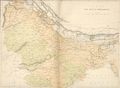
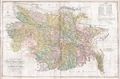 Bengal & Bihar in 1776 by James Rennell
 -
 Colonial Bengal, 19th century
 -
 Colonial Eastern Bengal and Assam, early 20th century
 -
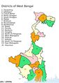 Map of West Bengal
 -
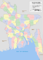 خريطة بنگلادش


الأعلام
-
 علم سلطنة البنغال
 -
 Flag of the Bengal Subah (15-18th Century)
 -
 Flag of Bengal Presidency, under British rule
 -
 علم بنگلادش أثناء حرب استقلال بنگلادش
 -
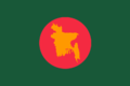
 علم بنگلادش

.svg&filetimestamp=20190923164329&)


السياسة
Politically, the region is divided between the People's Republic of Bangladesh, an independent state, and the eastern provinces of the Republic of India, including West Bengal, Assam and Tripura. Politically both Bangladesh and Indian Bengal are socialist, with left wing parties dominating the region's politics.
جمهورية بنگلادش

The state of Bangladesh is a parliamentary republic based on the Westminster system, with a written constitution and a President elected by parliament for mostly ceremonial purposes. The government is headed by a Prime Minister, who is appointed by the President from among the popularly elected 300 Members of Parliament in the Jatiyo Sangshad, the national parliament. The Prime Minister is traditionally the leader of the single largest party in the Jatiyo Sangshad. Under the constitution, while recognising Islam as the country's established religion, the constitution grants freedom of religion to non-Muslims.
Between 1975 and 1990, Bangladesh had a presidential system of government. Since the 1990s, it was administered by non-political technocratic caretaker governments on four occasions, the last being under military-backed emergency rule in 2007 and 2008. The Awami League and the Bangladesh Nationalist Party (BNP) are the two largest political parties in Bangladesh.
Bangladesh is a member of the UN, WTO, IMF, the World Bank, ADB, OIC, IDB, SAARC, BIMSTEC and the IMCTC. Bangladesh has achieved significant strides in human development compared to its neighbours.
البنغال الهندية

West Bengal, Tripura and Assam (home to the Barak Valley) are provincial states of the Republic of India, with local executives and assemblies- features shared with other states in the Indian federal system. The president of India appoints a governor as the ceremonial representative of the union government. The governor appoints the chief minister on the nomination of the legislative assembly. The chief minister is the traditionally the leader of the party or coalition with most seats in the assembly. President's rule is often imposed in Indian states as a direct intervention of the union government led by the prime minister of India.
Each state has popularly elected members in the Indian lower house of parliament, the Lok Sabha. Each state nominates members to the Indian upper house of parliament, the Rajya Sabha.
The state legislative assemblies also play a key role in electing the ceremonial president of India. The former president of India, Pranab Mukherjee, was a native of West Bengal and a leader of the Indian National Congress.
The two major political forces in the Bengali-speaking zone of India are the Left Front and the Trinamool Congress, with the Bharatiya Janata Party (BJP) and the Indian National Congress being minor players.
العلاقات عبر الحدود
India and Bangladesh are the world's second and eighth most populous countries respectively. Bangladesh-India relations began on a high note in 1971 when India played a major role in the liberation of Bangladesh, with the Indian Bengali populace and media providing overwhelming support to the independence movement in the former East Pakistan. The two countries had a twenty five-year friendship treaty between 1972 and 1996. However, differences over river sharing, border security and access to trade have long plagued the relationship. In more recent years, a consensus has evolved in both countries on the importance of developing good relations, as well as a strategic partnership in South Asia and beyond. Commercial, cultural and defense cooperation have expanded since 2010, when Prime Ministers Sheikh Hasina and Manmohan Singh pledged to reinvigorate ties.
The Bangladesh High Commission in New Delhi operates a Deputy High Commission in Kolkata and a consular office in Agartala. India has a High Commission in Dhaka with consulates in Chittagong and Rajshahi. Frequent international air, bus and rail services connect major cities in Bangladesh and Indian Bengal, particularly the three largest cities- Dhaka, Kolkata and Chittagong. Undocumented immigration of Bangladeshi workers is a controversial issue championed by right-wing nationalist parties in India but finds little sympathy in West Bengal.[21] India has since fenced the border which has been criticized by Bangladesh.[22]
الديمغرافيا


الاقتصاد
.jpg&filetimestamp=20190923164309&)

.jpg&filetimestamp=20190923164308&)
Historically, Bengal has been the industrial leader of the subcontinent.
المدن الرئيسية
Metropolises
The following are the largest cities in Bengal (in terms of population):


| Rank | City | Country | Population (2011) | Image |
|---|---|---|---|---|
| 1 | Dhaka | 8,906,039[23] |  | |
| 2 | Kolkata | 4,496,694[24] |  | |
| 3 | Chittagong | 2,592,439[25] |  | |
| 4 | Khulna | 664,728[26] |  | |
| 5 | Durgapur | 566,517[27] |  | |
| 6 | Asansol | 563,917[28] |  | |
| 7 | Bogra | 540,000[26] |  | |
| 8 | Sylhet | 526,412[26] |  | |
| 9 | Siliguri | 513,264[29][30] |  | |
| 10 | Rajshahi | 449,756[26] |  | |
| 11 | Agartala | 400,004[31] |  |
Major ports
.JPG&filetimestamp=20190923164313&)
| Port Name | Type | Status | Location | Country |
|---|---|---|---|---|
| Port of Chittagong | Sea Port | Active | Chittagong, Chittagong | |
| Port of Haldia | Sea Port River Port |
Active | Haldia, East Midnapur | |
| Port of Mongla | Sea Port | Active | Mongla, Bagerhat, Khulna | |
| Port of Payra | Sea Port | Active | Kalapara, Patuakhali, Barisal | |
| Port of Kolkata | River Port | Active | Kolkata, Kolkata | |
| Port of Narayanganj | River Port | Active | Narayanganj, Dhaka | |
| Port of Benapole-Petrapole | Landport | Active | Sharsha, Jessore-Bangaon, North 24 Parganas |
Tourist attractions
| Name | Type | City/Area | Sample Image |
|---|---|---|---|
| Sundarbans | World's largest natural mangrove forest |  | |
| Cox's Bazar | World's longest uninterrupted sea beach |  | |
| Kuakata | Sea beach |  | |
| Digha | Sea beach |  | |
| Chittagong Hill Tracts | Hilly areas inhabited by different indigenous tribes |  | |
| Ratargul | Only swamp forest in the Bengal region |  | |
| Lawachara National Park | Major national park and nature reserve |  | |
| Satchhari | Reserve forest |  | |
| Siliguri | Hilly area of foothills of Himalayas | |
الأهمية الاستراتيجية
.jpg&filetimestamp=20190923164322&)
The Bengal region is located at the crossroads of two huge economic blocs, the SAARC and ASEAN. It gives access to the sea for the landlocked countries of Bhutan and Nepal, as well as the Seven Sister States of North East India. It is also located near China's southern landlocked region, including Yunnan and Tibet.
الثقافة
| جزء من سلسلة عن |
| ثقافة البنغال |
|---|
 |
| التاريخ |
| المطبخ |
|
|
اللغة

العملة

In both Bangladesh and West Bengal, currency is commonly denominated as taka. The Bangladesh taka is an official standard bearer of this tradition, while the Indian rupee is also written as taka in Bengali script on all of its banknotes. The تاريخ التاكا dates back centuries. Bengal was home one of the world's earliest coin currencies in the first millennium BCE. Under the Delhi Sultanate, the taka was introduced by محمد بن تغلق في 1329. Bengal became the stronghold of the taka. The silver currency was the most important symbol of sovereignty of the Sultanate of Bengal. It was traded on the Silk Road and replicated in Nepal and China's Tibetan protectorate. The Pakistani rupee was scripted in Bengali as taka on its banknotes until Bangladesh's creation in 1971.
الأدب

Bengali literature has a rich heritage. It has a history stretching back to the 3rd century BCE, when the main language was Sanskrit written in the brahmi script. The Bengali language and script evolved circa 1000 CE from Magadhi Prakrit. Bengal has a long tradition in folk literature, evidenced by the Chôrjapôdô, Mangalkavya, Shreekrishna Kirtana, Maimansingha Gitika or Thakurmar Jhuli.
الفن

The Pala-Sena School of Art developed in Bengal between the 8th and 12th centuries and is considered a high point of classical Asian art.[32][33] It included sculptures and paintings.[34]
العمارة

العلوم


The Gupta dynasty, which is believed to have originated in North Bengal, pioneered the invention of chess, the concept of zero, the theory of Earth orbiting the Sun, the study of solar and lunar eclipses and the flourishing of Sanskrit literature and drama.[35]خطأ استشهاد: إغلاق </ref> مفقود لوسم <ref> The 19th century mystic poet Lalon Shah is the most celebrated practitioner of the tradition.[36] Other folk music forms include Gombhira, Bhatiali and Bhawaiya. Hason Raja is a renowned folk poet of the Sylhet region. Folk music in Bengal is often accompanied by the ektara, a one-stringed instrument. Other instruments include the dotara, dhol, flute, and tabla. The region also has a rich heritage in North Indian classical music.
المطبخ
القوارب

الملبس
Bengali women commonly wear the shaŗi and the salwar kameez, often distinctly designed according to local cultural customs. In urban areas, many women and men wear Western-style attire. Among men, European dressing has greater acceptance. Men also wear traditional costumes such as the kurta with dhoti or pyjama, often on religious occasions. The lungi, a kind of long skirt, is widely worn by Bangladeshi men.
الأعياد
انظر أيضاً
- Bengali Renaissance
- Bengalis
- Greater Bengal
- East India
- Hindi Belt
- List of Bengalis
- North-East India
- Punjab
Notes
References
- ^ "Article 2. The state language". The Constitution of the People's Republic of Bangladesh. Ministry of Law, The People's Republic of Bangladesh. Archived from the original on 5 August 2017. Retrieved 1 February 2017.
{{cite book}}:|website=ignored (help) - ^ "Report of the Commissioner for linguistic minorities: 47th report (July 2008 to June 2010)" (PDF). Commissioner for Linguistic Minorities, Ministry of Minority Affairs, Government of India. pp. 122–126. Archived from the original (PDF) on 13 May 2012. Retrieved 30 September 2017.
- ^ "Oxford Dictionaries". Archived from the original on 29 August 2017. Retrieved 22 February 2017.
- ^ Lethbridge, E. (1874). An Easy Introduction to the History and Geography of Bengal: For the Junior Classes in Schools. Thacker. p. 5. Retrieved 7 January 2017.
- ^ أ ب Akhter, Nasrin (2012). "Sarkar". In Islam, Sirajul; Jamal, Ahmed A. (eds.). Banglapedia: National Encyclopedia of Bangladesh (Second ed.). Asiatic Society of Bangladesh.
- ^ David Christiana (1 سبتمبر 2007). "Arsenic Mitigation in West Bengal, India: New Hope for Millions" (PDF). Southwest Hydrology. p. 32. Archived (PDF) from the original on 5 مارس 2016. Retrieved 20 ديسمبر 2008.
- ^ Puri, Sunil (2007). Agroforestry: Systems and Practices. ISBN 9788189422622.
- ^ Reddy, Angadi Ranga (2009). Gandhi and globalisation. ISBN 9788183242967.
- ^ Deen, Prof. S. M. (2014). A Brief History of Bengal for Diaspora Bangladeshis. Lulu Press, Inc. p. 59. ISBN 978-1-326-02377-5.
- ^ Das, Tulshi Kumar (2000). Social Structure and Cultural Practices in Slums: A Study of Slums in Dhaka City. ISBN 9788172111106.
- ^ Andaya, B. W.; Andaya, L. Y. (2015). A History of Early Modern Southeast Asia, 1400–1830. Cambridge University Press. p. 220. ISBN 978-0-521-88992-6. Retrieved 7 January 2017.
- ^ Singh, A. K. (2006). Modern World System and Indian Proto-industrialization: Bengal 1650–1800. Vol. 1. Northern Book Centre. p. 225. ISBN 9788172112011. Retrieved 7 January 2017.
- ^ Banu, U. A. B. Razia Akter (1992). Islam in Bangladesh. Brill. p. 6. ISBN 978-90-04-09497-0. Retrieved 7 January 2017.
in Samatata (South-east Bengal) where the Buddhist Khadaga dynasty ruled throughout the fifth, sixth and seventh centuries AD.
- ^ Rashid, M Harunar (2012). "Harikela". In Islam, Sirajul; Jamal, Ahmed A. (eds.). Banglapedia: National Encyclopedia of Bangladesh (Second ed.). Asiatic Society of Bangladesh.
- ^ "Bangladesh finds 106 tigers in Sundarbans, India 76". Dhaka Tribune. BSS. 4 أكتوبر 2015. Archived from the original on 11 سبتمبر 2016. Retrieved 13 أغسطس 2016.
- ^ "History of Bangladesh". Bangladesh Student Association. Archived from the original on 19 December 2006. Retrieved 26 October 2006.
- ^ "4000-year old settlement unearthed in Bangladesh". Xinhua News Agency. مارس 2006. Archived from the original on 10 مايو 2007. Retrieved 25 فبراير 2007.
- ^ Eaton, R. M. (1996). The Rise of Islam and the Bengal Frontier, 1204–1760. University of California Press. ISBN 978-0-520-20507-9. Retrieved 7 January 2017.
- ^ "Communist rule ends in Indian state of West Bengal". BBC News. 13 May 2011. Archived from the original on 18 August 2016. Retrieved 21 June 2018.
- ^ Bhattacharyya, B. (1986). Tripura Administration: The Era of Modernisation, 1870–1972. Mittal Publications. Retrieved 7 January 2017.
- ^ "Address by External Affairs Minister Shri Natwar Singh at India-Bangladesh Dialogue Organised by Centre for Policy Dialogue and India International Centre". Speeches. Ministry of External Affairs, New Delhi. 7 August 2005. Archived from the original on 5 May 2016. Retrieved 28 April 2016.
- ^ Chattopadhyay, S. S. (يونيو 2007). "Constant traffic". Frontline. Vol. 24, no. 11. The Hindu. Archived from the original on 17 أبريل 2008. Retrieved 26 فبراير 2008.
{{cite magazine}}: Invalid|ref=harv(help) - ^ "Dhaka (Bangladesh): City Districts and Subdistricts – Population Statistics in Maps and Charts". Archived from the original on 9 July 2014. Retrieved 6 March 2014.
- ^ "Kolkata Metropolitan". Archived from the original on 17 July 2015. Retrieved 10 August 2015.
- ^ "Chittagong (Bangladesh): City Districts and Subdistricts – Population Statistics in Maps and Charts". Archived from the original on 6 March 2014. Retrieved 6 March 2014.
- ^ أ ب ت ث "Bangladesh: Divisions and Urban Areas". Archived from the original on 6 March 2014. Retrieved 17 April 2014.
- ^ "West Bengal: Durgapur". Census of India.
- ^ "West Bengal: Asansol". Census of India.
- ^ "West Bengal: Siliguri (Part – Darjiling)". Census of India.
- ^ "West Bengal: Siliguri (Part – Jalpaiguri)". Census of India.
- ^ "Tripura: Agartala". Census of India.
- ^ Bagchi, J. (1993). The History and Culture of the Pālas of Bengal and Bihar, Cir. 750 A.D.-cir. 1200 A.D. Abhinav Publications. p. 127. ISBN 9788170173014. Retrieved 7 January 2017.
- ^ Huntington, S. L. (1984). The "Påala-Sena" Schools of Sculpture. E.J. Brill. p. 4. ISBN 9789004068568. Retrieved 7 January 2017.
- ^ "Pala art | Britannica.com". Encyclopædia Britannica. Archived from the original on 3 October 2016. Retrieved 7 January 2017.
- ^ خطأ استشهاد: وسم
<ref>غير صحيح؛ لا نص تم توفيره للمراجع المسماةMurray 1913 - ^ Banik, Nandadulal. "Anirvan". Banglapedia. Asiatic Society of Bangladesh. Archived from the original on 3 فبراير 2016. Retrieved 5 أغسطس 2015.
External links
- Bangladesh at the Open Directory Project
- West Bengal at the Open Directory Project
- CS1 errors: periodical ignored
- Short description is different from Wikidata
- Articles containing بنغالي-language text
- Pages using infobox mapframe without shape links in Wikidata
- Pages using infobox settlement with no map
- Pages using infobox settlement with no coordinates
- Pages with plain IPA
- Articles with hatnote templates targeting a nonexistent page
- All articles with self-published sources
- Articles with self-published sources from November 2018
- Articles with unsourced statements from June 2017
- Bengal
- مناطق آسيا
- Geography of South Asia
- Geography of Bangladesh
- Geography of India
- History of Bangladesh
- History of West Bengal
- مناطق الهند
- مناطق هندية تاريخية
- تقسيمات الهند البريطانية
- بنغال
- جغرافيا بنگلادش
- جغرافيا الهند
- تاريخ بنگلادش
- تاريخ الهند الإقليمي
- مناطق مقسمة
- صفحات مع الخرائط