الأراضي البلغارية عبر الدانوب
في التأريح البلغاري، الأراضي البلغارية عبر الدانوب، والتي تُدعى أيضاً بلغاريا عبر الدانوب (بالبلغارية: Отвъддунавска България)، تشير إلى الأراضي الواقعة تحت سيطرة الإمبراطورية البلغارية شمال الدانوب. تلك الأراضي تغطي ما يشكل اليوم أراضي رومانيا ومولدوڤا وشرق المجر وڤويڤودينا في صربيا و بودياك في أوكرانيا.[1][2][3]
في العصور الوسطى سيطرت الامبراطورية البلغارية على مناطق شاسعة شمال نهر الدانوب (بانقطاعات) منذ تأسيسها في 681 وحتى تشظيها في 1371-1422. تلك الأراضي كان المؤرخون البيزنطيون المعاصرين لها يسمونها بلغاريا عبر الدانوب. وثمة ندرة في المعلومات الأصلية للحكم البلغاري الذس استمر قروناً هناك، إذ أن أرشيفات الحكام البلغار دُمـِّرت وقليلٌ هو المذكور عن تلك المنطقة في المخطوطات البيزنطية أو المجرية.
الإمبراطورية البلغارية الأولى
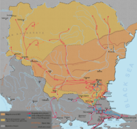
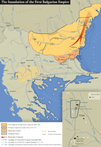
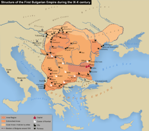
بعد تفكك بلغاريا الكبرى بوفاة الخان كوبرات في 668، اِتـَّبعـَت مجموعة كبيرة من البلغار الابن الثالث للخان الأكبر، أسپاروخ, who headed westwards. In the 670's they settled in the area known as the Ongal to the north of the Danube delta. From there Asparukh's cavalry in alliance with local Slavs annually attacked the Byzantine territories in the south. In 680 the Byzantine Emperor Constantine IV lead a large army to face the Bulgars but was defeated in the battle of Ongal and as a result the Byzantines were forced to acknowledge the formation of a new country، الامبراطورية البلغارية الأولى. The northern border of the country followed the southern slopes of the Carpathian mountains from the Iron Gates and reached the Dneper river (or possibly just the Dniester river) إلى الشرق.
The Bulgarian's main rivals in the area were the Avars to the west and the Khazars to the east. The latter were a serious threat: after they crushed the resistance of Kubrat's eldest son, Bayan they marched westwards. They waged a war against Asparukh who perished in battle fighting the invaders in 700.
To protect their northern borders, the Bulgarians built several enormous ditches which ran throughout the whole length of the border from the Timok river to the Black Sea.
In 803 Krum became Khan. The new energetic ruler pointed his attention to the north-west where Bulgaria's old enemies, the Avars experienced difficulties and setbacks against the Franks under Charlemagne. Between 804 and 806 the Bulgarian armies militarily annihilated the Avars and destroyed their state. Krum took the eastern parts of the former Avar Khaganate and took over rule of the local Slavic tribes. Bulgaria's territory extended twice from the middle Danube to the north of Budapest to the Dnester though possession of Transylvania is debatable.
في 813 استولى الخان كروم على أودرين ونهب كل شرق تراقيا. وقد أخذ 50,000 أسيراً من أولئك الذين استوطنوا في بلغاريا عبر الدانوب.
During the First Bulgarian Empire, the Balkan–Danubian culture developed in the 8th century and flourished until the 11th century[4][5]. It represents an early medieval archaeological culture which emerged in the region of the Lower Danube. In Romania it is called Dridu culture[4][5] while in Bulgaria it is usually referred to as Pliska-Preslav culture.[6]
الإمبراطورية البلغارية الثانية
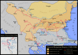
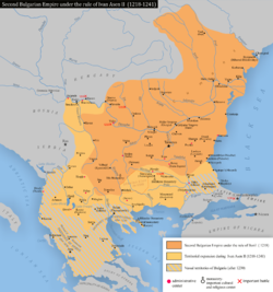
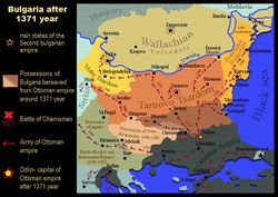
There is evidence that the الامبراطورية البلغارية الثانية ruled at least nominally the Wallachian lands up to the Rucăr–Bran corridor as late as the late 14th century. In a charter by Radu I, the Wallachian voivode requests that tsar Ivan Alexander of Bulgaria order his customs officers at Rucăr and the Dâmboviţa River bridge to collect tax following the law. The presence of Bulgarian customs officers at the Carpathians indicates a Bulgarian suzerainty over those lands, though Radu's imperative tone hints at a strong and increasing Wallachian autonomy.[7]
انظر أيضاً
المراجع
- ^ THE ROLE AND ADMINISTRATIVE ORGANIZATION OF THE SO-CALLED "TRANSDANUBIAN BULGARIA", in Bulgarian; Vasilka Tăpkova-Zaimova
- ^ POLITICAL GEOGRAPHY OF MEDIEVAL BULGARIA. PART ONE FROM 681 TO 1018; Peter Koledarov
- ^ Political geography of the mediaeval Bulgarian state. Part II. From 1186 to 1396; Peter Koledarov
- ^ أ ب Opreanu 2005, p. 127.
- ^ أ ب Spinei 2009, p. 87.
- ^ Плиска-Преслав: Прабългарската култура, Том 2, Българска академия на науките Археологически институт и музей, 1981.
- ^ Павлов, Пламен. "За северната граница на Второто българско царство през XIII-XIV в." (in Bulgarian). LiterNet. Retrieved 2009-10-08.
{{cite web}}: CS1 maint: unrecognized language (link)
- Petăr Koledarov, Političeska geografija na srednovekovnata bălgarska dăržava, vol. 1, Sofija 1979.
- Vasilka Tăpkova-Zaimova, "Roljata i administrativnata organizacija na t. nar. 'otvăd-dunavska Bălgarija'" in Studia Balcanica: proučvanija po slučaj vtorija meždunaroden kongres po balkanistika, Sofija 1970.
- Ian Mladjov, "Trans‐Danubian Bulgaria: Reality and Fiction", in Byzantine Studies/Etudes Byzantines, n.s. 3, 1998 [2000], 85–128.

