ڤوج (إقليم)
ڤوج
Vosges | |
|---|---|
   .jpg&filetimestamp=20220801021306&) | |
 Flag  Coat of arms | |
 Location of Vosges in France | |
| Coordinates: 48°10′N 06°25′E / 48.167°N 6.417°E | |
| البلد | فرنسا |
| المنطقة | اللورين |
| عاصمة الإقليم | إپينال |
| مراكز الدوائر | Neufchâteau Saint-Dié-des-Vosges |
| Government | |
| • President of the General Council | Christian Poncelet |
| Area | |
• Total | 5٬874 كم² (2٬268 ميل²) |
| Population (1999) | |
• Total | 380٬952 |
| • Rank | 60 |
| • Density | 65/km2 (170/sq mi) |
| Time zone | UTC+1 (CET) |
| • Summer (DST) | UTC+2 (CEST) |
| رقم الإقليم | 88 |
| الدوائر الادارية | 3 |
| الكانتونات | 31 |
| الكميونات | 515 |
| ^1 French Land Register data, which exclude estuaries, and lakes, ponds, and glaciers larger than 1 km2 | |
| جزء من سلسلة عن |
| لورين |
|---|
 |
ڤوج (فرنسية: Vosges؛ النطق الفرنسي: [voʒ]) هي إقليم في منطقة گراند إست في شمال شرق فرنسا، مسمى على اسم سلسلة الجبال المحلية. يتألف الإقليم من 31 كانتون و 515 كميونة (قرية أو بلدة) منهم 242 ريفيين.[1] ويضم مسقط رأس جان دارك، دومريمي.[2]
التاريخ
حرب المائة عام
Joan of Arc was born in the village of Domrémy, then in the French part of the Duchy of Bar, or Barrois mouvant, located west of the Meuse. The part of the duchy lying east of the Meuse was part of the Holy Roman Empire. The Duchy of Bar later became part of the province of Lorraine. The village of Domrémy was renamed Domrémy-la-Pucelle in honour of Joan.[3]
الثورة الفرنسية
The Vosges department is one of the original 83 departments of France, created on 4 March 1790 during the French Revolution.[4] It was made of territories that had been part of the province of Lorraine. In German it is referred to as Vogesen.
In 1793, the independent Principality of Salm-Salm (town of Senones and its surroundings), enclosed inside the Vosges department, was annexed to France and incorporated into Vosges. In 1795, the area of Schirmeck was detached from the Bas-Rhin department and incorporated into the Vosges department.[5] The Vosges department then had an area of 6,127 km2 (2,366 sq miles), which it kept until 1871.
In 1794, Vosges was the site of a major battle between the forces of Revolutionary France and the Allied Coalition. The oldest square in Paris, Place Royale, was renamed Place des Vosges in 1800 when the department became the first to pay the new revolutionary taxes.
الحرب الپروسية الفرنسية
After the French defeat in the Franco-Prussian War of 1870–1871, 4% of the Vosges department in the extreme northeast of the department was annexed to the German Empire by the Treaty of Frankfurt on the ground that the people there spoke Germanic dialects. The area annexed on May 18, 1871, corresponded to the canton of Schirmeck and the northern half of the canton of Saales. Schirmeck and Saales had been historically part of Alsace. These territories, along with the rest of Alsace and the annexed territories of Lorraine, became part of the Reichsland of Elsaß-Lothringen. The area of the Vosges department was thus reduced to its current 5,874 km2 (2,268 sq. miles).
الحربان العالميتان
في 1919، مع انتصار الحلفاء في الحرب العالمية الأولى، أعادت ألمانيا الألزاس-لورين إلى فرنسا في معاهدة ڤرساي. إلا أن شيرمك و Saales لم تعادا إلى إقليم ڤوج، ولكن بدلاً من ذلك ضُمتا إلى إقليم الراين الأسفل المعاد تشكيله.
المهمة سيئة الحظ التي قامت بها الخدمة الجوية الخاصة (SAS) والمسماة العملية لويتون وقعت في غابات ڤوج في 1944.
يوجد العديد من المقابر العسكرية في الإقليم، أكبرهم هو Epinal American Cemetery and Memorial في دينوزيه، بالقرب من إپينال. وقد بنتها الفرقة 45 مشاة الأمريكية في سبتمبر 1944 واكتملت في 1959. 5,253 جندي سقطوا صرعى الوغى في فرنسا، الڤوج، وادي الراين وألمانيا مدفونون هناك.[6]
الجغرافيا
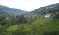
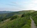
While the west part of the Vosges is flat sedimentary land (well suited for mineral waters), the east is dominated by the Vosges Mountain range and the Ballons des Vosges Nature Park. The Hohneck at 1363m is the highest peak of the Vosges department.[7] The Monts Faucilles traverse the south of the department in a broad curve declining on the north into elevated plateaus, on the south encircling the upper basin of the River Saône. This chain, dividing the basins of the Rhône and the Rhine, forms part of the European watershed between the basins of the Mediterranean and Atlantic.[8] 48% of the department is covered by woodlands and forests (the third highest in France), while 45% of land is in agricultural use.[9]
The Saône (named after the Celtic goddess Sagona)[10] rises at Vioménil, in the Vosges. The Anger river also passes through it.
البلدات الرئيسية
The most populous commune is Épinal, the prefecture. As of 2019, there are 9 communes with more than 5,000 inhabitants:[11]
| Commune | Population (2019) |
|---|---|
| Épinal | 32,256 |
| Saint-Dié-des-Vosges | 19,576 |
| Golbey | 8,798 |
| Thaon-les-Vosges | 8,634 |
| Gérardmer | 7,807 |
| Remiremont | 7,691 |
| Neufchâteau | 6,636 |
| Raon-l'Étape | 6,205 |
| Rambervillers | 5,096 |
السكان
Population development since 1801:
|
| |||||||||||||||||||||||||||||||||||||||||||||||||||||||||||||||||||||||||||||||||
| Sources:[4][12] | ||||||||||||||||||||||||||||||||||||||||||||||||||||||||||||||||||||||||||||||||||
Culture
The Roman fortified town of Grand, located 30 km from Toul, has an amphitheatre and a temple to the Cult of Apollo. At La Bure, located a few kilometres from Saint-Dié-des-Vosges, archaeologists have found evidence for human habitation going back to around 2000 BC.
Séré de Rivières forts
As a border area, the Vosges region was a route for possible invasion. As such four important forts were constructed in the department: Bourlémont Fort in Mont-les-Neufchâteau (built between 1878 and 1881); Uxegney Fort (built between 1882 and 1884); Bois l'Abbé Fort (built in 1884 and 1885); and the Le Parmont Fort in Remiremont (built between 1874 and 1876).[13]
السياسة
The president of the Departmental Council is François Vannson, first elected in 2015.
الانتخابات الرئاسية - الجولة الثانية
| Election | Winning Candidate | Party | % | 2nd Place Candidate | Party | % | |
|---|---|---|---|---|---|---|---|
| 2022 | إيمانوِل ماكرون | LREM | 47.59 | Marine Le Pen | RN | 52.41 | |
| 2017[14] | إمانوِل ماكرون | LREM | 55.26 | Marine Le Pen | FN | 44.74 | |
| 2012 | Nicolas Sarkozy | UMP | 50.94 | François Hollande | PS | 49.06 | |
| 2007 | Nicolas Sarkozy | UMP | 54.72 | Ségolène Royal | PS | 45.28 | |
| 2002[14] | Jacques Chirac | RPR | 78.81 | Jean-Marie Le Pen | FN | 21.19 | |
| 1995[15] | Jacques Chirac | RPR | 51.44 | Lionel Jospin | PS | 48.56 | |
النواب في الجمعية الوطنية الحالية
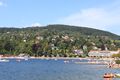
السياحة
-
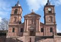
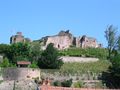 حصن إپينال
 -
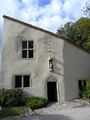 البيت مسقط رأس جان دارك في دومريمي-لا-پوسل
 -
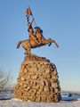 تمثال جان دارك، مقام في 1909 على الحدود السابقة مع الألزاس-لورين
 -
-
-
-


انظر أيضاً
الهامش
- ^ "The Vosges Departmental Tourist Board - The département: a few figures". Tourismevosges.fr. Retrieved 2012-09-22.
- ^ "Jeanne d'arc Domremy-la-Pucelle Centre Johannique, Centre d'Interprétation Vosges". Tourismevosges.fr. Retrieved 2012-09-22.
- ^ Condemnation trial, p. 37.[1]. Retrieved 23 March 2006.
- ^ أ ب "Historique des Vosges". Le SPLAF.
- ^ P.S. (2002). "L'Essor, Revue trimestrielle de Schirmeck" (PDF). Le Pays Lorrain (in الفرنسية). Société d'archéologie lorraine et du Musée historique lorrain. 83: 255. ISSN 0031-3394. Retrieved 3 August 2009.
- ^ "Cimetière americain". Tourisme Vosges. Retrieved 12 July 2022.
- ^ "Stèles du sommet du Hohneck". Tourisme Vosges. Retrieved 12 July 2022.
- ^ One or more of the preceding sentences incorporates text from a publication now in the public domain: Chisholm, Hugh, ed. (1911). . دائرة المعارف البريطانية. Vol. 28 (eleventh ed.). Cambridge University Press. p. 214.
{{cite encyclopedia}}: Cite has empty unknown parameter:|coauthors=(help) This entry further details the industrial base at the time. - ^ "Vosges - Chiffres clés". Vosges Conseil Départemental. Retrieved 12 July 2022.
- ^ "The Vosges Departmental Tourist Board - Archeological sites". Tourismevosges.fr. Archived from the original on 1 April 2013.
- ^ Populations légales 2019: 88 Vosges, INSEE
- ^ "Évolution et structure de la population en 2016". INSEE.
- ^ "The Vosges Departmental Tourist Board - Forts and cemeteries". Tourismevosges.fr. Archived from the original on 1 April 2013.
- ^ أ ب l'Intérieur, Ministère de. "Présidentielles". interieur.gouv.fr.
- ^ "Résultats de l'élection présidentielle de 1995 par département - Politiquemania". www.politiquemania.com.
- ^ "Assemblée nationale ~ Les députés, le vote de la loi, le Parlement français". Assemblée nationale (in الفرنسية). Retrieved 2021-11-08.
{{cite web}}: CS1 maint: url-status (link)
وصلات خارجية
- (بالفرنسية) Vosges.com Economic information about the Vosges
- Climbbybike.com: All information on and profiles of the climbs and cols of the Vosges
- (بالفرنسية) General Council website
- (بالفرنسية) Prefecture website
- (بالفرنسية) Vosges vacations
- (إنگليزية) Information - Vosges.us
- Illustrated Article on the Vosges Battlefields in Winter at 'Battlefields Europe'
 Chisholm, Hugh, ed. (1911). . دائرة المعارف البريطانية (eleventh ed.). Cambridge University Press.
 {{cite encyclopedia}}: Cite has empty unknown parameter:|coauthors=(help)- "[[s:Collier's New Encyclopedia (1921)/{{{1}}}|{{{1}}}]]". Collier's New Encyclopedia. 1921.
- Pages using gadget WikiMiniAtlas
- صفحات ذات رسوم بيانية قديمة فيغا
- صفحات بها مخططات
- CS1 الفرنسية-language sources (fr)
- مقالات المعرفة المحتوية على معلومات من دائرة المعارف البريطانية طبعة 1911
- Wikipedia articles incorporating text from the 1911 Encyclopædia Britannica
- CS1 maint: url-status
- Short description is different from Wikidata
- Coordinates on Wikidata
- Articles containing فرنسية-language text
- Pages using Lang-xx templates
- أقاليم فرنسا
- ڤوج
- تأسيسات 1790 في فرنسا
- Grand Est region articles needing translation from French Wikipedia
- أقاليم گراند إست
- دول وأقاليم تأسست في 1790