خليج سپنسر

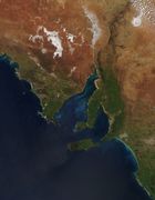
خليج سپنسر Spencer Gulf، أحد المدخلين الكبار للساحل الجنوبي الأسترالي، ويقع في ولاية أستراليا الجنوبية، قبالة الخليج الأسترالي العظيم. يمتد الخليج بطول 322 كم وعرض 129 كم عند مدخله. الشاطئ الغربي للخليج هو شبه جزيرة إير، والجانبه الشرقي شبه جزيرة يورك، والتي تفصله عن خليج سانت ڤنسنت الأصغر. مدخله عرفه ماثيو فلاندرز كخط يمتد من كيپ كاتاستروف على شبه جزيرة إير حتى كيپ سپنسر على شبه جزيرة يورك.[1]
أكبر البلدات على الخليج هي پورت لينكولن، وايالا، پورت پيري، وپورت أوگستا. البلدان الأصغر تشمل تومبي باي، پورت نيل، أرنو باي، كاول، پورت جرمين، پورت بروتون، والارو، پورت هيوز وپورت ڤكتوريا.
التاريخ
في 20 مارس 1802 أطلق عليه فلاندرز اسم خليج سپنسر، على اسم جورج جون سپنسر، إيرل ثاني سپنسر، الجد الأكبر لديانا، أميرة ويلز.[1]
الحياة البرية


مناطق الطيور الهامة
المنتزهات البحرية
المنتزهات البحرية في خليج سپنسر (من الشمال إلى الجنوب):
- منتزه خليج سپنسر البحري الشرقي[4]
- منتزه مجموعة ضفاف سير جوزف البحري[5]
- منتزه خليج سپنسر البحري الجنوبي[6]
الجزر
يضم خليج سپنسر عدد من الجزر الساحلية والبحرية. وهي (من الشمال إلى الجنوب):
- جزيرة كورلو (جنوب پورت أوگستا)
- جزيرة ويرونا (شمال پورت پيري)
- جزيرة شاگ (شمال پورت بروتون)
- جزيرة إنترانس (بالقرب من كاول)
- جزر بيرد (بالقرب من والارو)
- جزيرة ليپسون (شمال خليج تومبي)
- جزيرة تومبي (جنوب خليج تومبي)
- جزيرة واردانگ ومجموعة جزر گوز (بالقرب من پورت ڤيكتوريا)
- مجموعة ضفاف سير جوزف (قبالة خليج تومبي)
- جزيرة لوث وجزيرة رابيت (في خليج لوث)[7]
- جزيرة بوسطن (في خليج بوسطن)[7]
- جزيرة گرانتهام وجزر بيكر (في خليج پروپر)[7]
- جزيرة دونيگتون، كاركاس روك، جزيرة أوين، جزيرة تايلور، جزيرة گريندال، جزيرة ليتل، جزيرة لويس، جزيرة هوپكنز وجزيرة ثيستل (شرق شبه جزيرة جوسيو)..[7]
- جزيرة ميدل، جزيرة ساوث وجزيرة رويستون (في خليج پوندالوي)
- جزر گامبير تشمل جزيرة ودج (في مدخل خليج سپنسر)
مقترحات لتطوير الميناء
محطات تحلية مياه البحر
خليج سپنسر في الأفلام والڤيديو
منطقة خليج سپنسر، وحياتها البرية وتطورها كانت مادة لأفلام وثائقية حملت اسم كتلفيش كنتري.[8]
معرض الصور
-
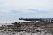
 مرفأ پورت بروتون على الشاطئ الشرقي لخليج سپنسر.
 -
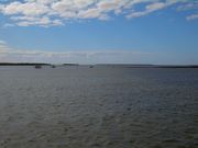
 خليج سپنسر كما يظهر من سواتل ناسا.
 -
 Moonta Bay Jetty on the Eastern shore of Spencer Gulf


المصادر
- ^ أ ب
Flinders, Matthew (1966) [1814]. A Voyage to Terra Australis : undertaken for the purpose of completing the discovery of that vast country, and prosecuted in the years 1801, 1802, and 1803 in His Majesty's ship the Investigator, and subsequently in the armed vessel Porpoise and Cumberland Schooner; with an account of the shipwreck of the Porpoise, arrival of the Cumberland at Mauritius, and imprisonment of the commander during six years and a half in that island (Facsimile ed.). Adelaide; Facsimile reprint of: London : G. and W. Nicol, 1814 ed. In two volumes, with an Atlas (3 volumes): Libraries Board of South Australia. p. 249. Retrieved 27 March 2013.
{{cite book}}: CS1 maint: location (link) - ^ "Upper Spencer Gulf marine park zones". Department of Environment, Water and Natural Resources. Retrieved 6 December 2013.
- ^ "Franklin Harbor". Department of Environment, Water and Natural Resources. Retrieved 6 December 2013.
- ^ "http://www.environment.sa.gov.au/marineparks/find-a-park/upper-spencer-gulf/franklin-harbor". Department of Environment, Water and Natural Resources. Retrieved 6 December 2013.
{{cite web}}: External link in|title= - ^ "Sir Joseph Banks Group Marine Park" Government of South Australia, Department of Environment. Retrieved 2013-12-06.
- ^ "Southern Spencer Gulf". Department of Environment, Water and Natural Resources. Retrieved 6 December 2013.
- ^ أ ب ت ث Royal Australian Navy Hydrographic Service Hydrographic Department, (1983). Port Lincoln and approaches (chart no. Aus 134).
{{cite book}}: Cite has empty unknown parameter:|coauthors=(help)CS1 maint: extra punctuation (link) - ^ Cuttlefish Country website (accessed 2013-11-05)