پالو، إلازيغ
پالو
Palu (بالتركية) Բալու (أرمنية) | |
|---|---|
بلدية | |
 | |
 مقاطعة پالو في محافظة إلازيغ | |
 پالو | |
| Coordinates: 38°42′14″N 39°57′04″E / 38.70389°N 39.95111°E | |
| البلد | |
| المحافظة | إلازيغ |
| المقاطعة | پالو |
| Government | |
| • العمدة | إفرايم أونالان (AKP) |
| • قائمقام | طيفون دلي |
| Area | |
• Total | 840 كم² (320 ميل²) |
| Elevation | 1٬050 m (3٬440 ft) |
| Population (2021)[1] | |
• Total | 9٬602 |
| Postal code | 23500 |
| المناخ | Csa |
| Website | www |
پالو ( Palu ؛ بالأرمينية: Բալու؛ كردي: Palo[2]) هي بلدة في محافظة إلازيغ (معمورة العزيز) في شرق تركيا. وهي مقر مقاطعة پالو.[3] العمدة الحالي هو إفرايم أونالان (AKP).[4] يبلغ عدد سكانها 9,602 نسمة (2021).[1] وهي مأهولة منذ العصور القديمة، إذ كانت پالو عاصمة المنطقة الأرمنية الكلاسيكية Balabitene ثم أصبحت بعد ذلك بوقت طويل عاصمة إمارة پالو الكردية. وفي مطلع القرن العشرين، انتقلت پالو من موقعها القديم إلى موقعها الحالي.
الأسماء
كان اسمها اليوناني رومانوپوليس.[5] The name "Shebeteria", found in the Urartian inscription at the Palu citadel, may be Palu's ancient name.[6][7] The Urartian city called "Palua" has also been identified with Palu.[6] König and Burney also identified Palu with the "Uashtal" mentioned in Urartian sources, but according to R.D. Barnett this is unlikely.[7] James Howard-Johnston identifies Palu with the "Palios" mentioned by the 7th-century geographer George of Cyprus.[8]
جغرافيا
تقع پالو على الضفة الشمالية لنهر مراد سو، at the lower end of a treeless plain bisected by a low line of hills.[9] The Palu plain has fertile soil and is today covered in farmland.[9] To the northeast is the stony Karakoçan plain.[9]
التاريخ


The story of Palu begins at the old site now called Eski Palu, just east of the modern town.[9] This site was inhabited continuously for over 2,500 years, from ancient Urartian times until the early 20th century, when the town was relocated to the modern site.[9] Palu's old town was built on a promontory above a U-shaped bend in the Murat Su.[9] Looming above the town center to the north was the imposing castle rock.[9] From this height, defenders would have had a commanding view of the entire Palu plain - from the town below, the low hills running through the middle of the plain would block your vision, but from the castle rock you could see over them to the far side of the plain.[9]
منذ العصر الأورارتي، إن لم يكن قبل ذلك، the castle rock at Eski Palu has been the site of a fortress.[9] Most traces of the Urartian fortress have been wiped out by later occupation.[10] One important remnant is an inscribed stele describing the Urartian king Menua's conquest of a region called Shebeteria - possibly an ancient name for Palu.[7][6] Menua established a temple to Ḫaldi at Shebeteria afterwards.[7]
Ancient Palu's population was likely culturally Urartian instead of just Urartian-ruled; there may have also been an Aramaic-speaking minority.[9] Three rock-cut tombs on the northwest side of the citadel suggest the presence of a rich upper class here.[10] There were important iron ore deposits in the Palu region, which together with copper deposits near Ergani may have been a strategic objective in the conflict between Urartu and Assyria.[6]
In classical times, Palu was the capital of the Armenian district of Balabitene, or Balahovit.[9] This consisted of the Palu plain and was a rich and fertile, if small, district.[9] The neighboring district of Paghnatun, based at Bağın, was probably politically subordinate to Balahovit.[9]
During the middle ages, Palu was a flourishing market town with a mixed Armenian and Syriac population.[9] It was far enough from major conflict zones that agriculture and animal husbandry were able to continue unimpeded.[9] Under Arab rule, Palu held strategic importance because it controlled a route to Erzurum.[9] Later, Palu formed part of the Artukid emirate of Harput; along with Kiğı, it was one of the main towns in the eastern part of the emirate.[9]
كانت پالو موقع حصن للآق قويونلو والذي بقي حتى أواخر القرن الخامس عشر، والذي استولى عليه حسين بك، القائد المرداسي من إمارة إغيل.[11] وقد أسس إمارة پالو، التي تواجدت من 1495 حتى 1845.[12] The town had a significant Armenian population until the Armenian genocide in 1915.[13]
قلعة پالو هـُجرت في وقتٍ ما في القرن السابع عشر، إلا أن البلدة استمرت مأهولة.[9] The old site of Eski Palu was eventually abandoned either during the First World War or shortly thereafter, and the town was relocated to its present site.[9]
المدينة استولت عليها لفترة وجيزة في 21 فبراير 1925 قوات الشيخ سعيد پيران أثناء تمرده.[14]
السكان
في بداية القرن التاسع عشر، قضاء پالو يسكنه 100,000 نسمة: 60–70% أرمن، والباقي أكراد وترك وعرب. According to the Armenian Patriarchate of Constantinople, 15,753 Armenians lived in the kaza on the eve of the First World War, with 38 churches, two monasteries and 26 schools.[5] The town of Balu had a mixed population of Armenians, Turks, Kurds, Syriacs, and Greeks with about 6,000 inhabitants in 1830-1850 and 10,000 in 1914. Half of the population was Armenian.[5]
| Turkish | Arabic | Kurdish | Circassian | Armenian | Unknown or other language |
|---|---|---|---|---|---|
| 8,816 | 2 | 26,008 | 6 | 174 | – |
| Muslim | Christian | Jewish | Unknown or other religion |
|---|---|---|---|
| 34,822 | 184 | – | – |
معالم


The fortress built on top of the castle rock consists of four walled enclosures, each one enclosing a distinct part of the mountain.[9] The outer enclosure occupies the relatively gentle western slope of the castle rock.[9] Above it is the main enclosure.[9] Inside it, at the very highest point of the citadel, is the top enclosure.[9] A fourth enclosure fortifies long rocky outcropping that juts out from the castle rock's west side.[9]
The surviving masonry walls and towers all seem to date from the late middle ages.[9] The Urartian inscription of Menua is located on the north side of the outer enclosure, just below a cliff that goes all the way up to the top enclosure.[9] Nearby are a series of rock-cut chambers which, according to local tradition, were the place where Mesrop Mashtots invented the Armenian alphabet.[9] A large Christian church is located on the east side of the main enclosure; it was built in the early 1800s.[9]
The Ulu Cami, or congregational mosque, is a simple structure with a long, low profile.[9] The current structure is from the 15th or 16th century, replacing an earlier mosque built under the Artukids.[9] There have since been significant changes to the Ulu Cami since then: for example, its minaret was built in 1660/61, and an outer courtyard was added in the early 20th century.[9] The mihrab is dated to 1750/51, and the original wooden minbar still exists, although the wooden gallery has decayed and partly broken down.[9] The aptly-named Küçük Cami, or "small mosque", is a 10x10 m square with thick walls.[9] Its dome has since collapsed.[9]
The large hammam, or bathhouse, dates from 1659/60 and is well-preserved.[9] From west to east, it had a large changing room, a cold room, and then a hot room.[9] The mosque and türbe of Cemşid Bey, said to have been a cavalry officer under Selim I, is located further north and is still in use as a village mosque.[9] The mosque appears to have been built before the türbe, so Cemşid's role in their construction is unclear.[9] Two other old mosques exist in this northern area: the Alacalı Mescit, which was built in either the 16th or early 17th century, and the Merkez Cami, or "central mosque", which was built in 1874.[9]
-
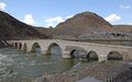 جسر على نهر مراد، وتظهر كنيسة في الخلفية
 -
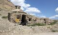
 الجامع الصغير
 -
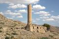 أولو جامع
 -
 حمام
حمام -
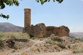
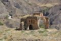 كنيسة
كنيسة


أشخاص بارزون
- كاثرين مگاريان[16]
- صلاح الدين دمرداش[17]
- الشيخ سعيد[14]
- يوسف خربوطلي، مغني، مواليد 1981.
المراجع
- ^ أ ب "Population Of Municipalities, Villages And Quarters". TÜİK. Retrieved 18 December 2022.
- ^ Avcıkıran, Adem (2009). Kürtçe Anamnez, Anamneza bi Kurmancî (in الكردية and التركية). p. 56.
- ^ İlçe Belediyesi, Turkey Civil Administration Departments Inventory. Retrieved 18 December 2022.
- ^ Şafak, Yeni (2019-06-11). "Elazığ Palu Seçim Sonuçları – Palu Yerel Seçim Sonuçları". Yeni Şafak (in التركية). Retrieved 2019-11-06.
- ^ أ ب ت "Kaza Balu – Բալու / Balahovit / Palu". Virtual Genocide Memorial (in الإنجليزية الأمريكية). Retrieved 2023-09-18.
- ^ أ ب ت ث Çifçi, Ali (2017). The Socio-Economic Organisation of the Urartian Kingdom. Leiden: Koninklijke Brill. ISBN 978-90-04-34759-5. Retrieved 22 August 2022.
- ^ أ ب ت ث Barnett, R.D. (1982). "Urartu". In Boardman, John; Edwards, I.E.S.; Hammond, N.G.L.; Sollberger, E. (eds.). The Cambridge Ancient History, Second Edition, Vol. 3. Cambridge: Cambridge University Press. pp. 314–71. ISBN 0-521-22496-9. Retrieved 22 August 2022.
- ^ Howard-Johnston, James (2006). East Rome, Sasanian Persia and the End of Antiquity. Ashgate. ISBN 0-86078-992-6. Retrieved 25 July 2022.
- ^ أ ب ت ث ج ح خ د ذ ر ز س ش ص ض ط ظ ع غ ف ق ك ل م ن هـ و ي أأ أب أت أث أج أح أخ أد أذ أر أز Sinclair, T.A. (1989). Eastern Turkey: An Architectural & Archaeological Survey, Volume III. Pindar Press. ISBN 0907132340. Retrieved 29 July 2022.
- ^ أ ب Sevin, Veli (1994). "Three Urartian Rock-Cut Tombs from Palu". Tel Aviv. 21 (1): 58–67. doi:10.1179/tav.1994.1994.1.58. Retrieved 22 August 2022.
- ^ Serdar Karabulut, eyeyh Ali Sebiti al-Palevi, Gold Pen Publications, mitzmit, 2014, p.33
- ^ The Kurds: An Encyclopedia of Life, Culture, and Society [1]
- ^ Üngör, Uğur Ümit (2012). The Making of Modern Turkey: Nation and State in Eastern Anatolia, 1913-1950. Oxford University Press. p. 81. ISBN 9780199655229.
- ^ أ ب Olson, Robert W. (1989). The emergence of Kurdish nationalism and the Sheikh Said Rebellion, 1880-1925. University of Texas Press. ISBN 978-0-292-77619-7.
- ^ أ ب 1927 NÜFUS SAYIMI SONUÇLARINA GÖRE ELAZIĞ NÜFUSU
- ^ "Katherine Magarian". armeniapedia.org.
- ^ "Who's who in Politics in Turkey" (PDF). Heinrich Böll Stiftung. pp. 232–235. Archived from the original (PDF) on 15 November 2019. Retrieved 7 April 2021.
| هذا geographical article about a location in Elazığ Province, Turkey هو بذرة. بإمكانك مساعدة المعرفة بأن تنمـِّـيـه. |
- Pages using gadget WikiMiniAtlas
- CS1 الكردية-language sources (ku)
- CS1 التركية-language sources (tr)
- CS1 الإنجليزية الأمريكية-language sources (en-us)
- Short description is different from Wikidata
- Coordinates on Wikidata
- Pages using infobox settlement with unknown parameters
- Articles containing أرمنية-language text
- Articles containing كردي-language text
- Pages using Lang-xx templates
- District municipalities in Turkey
- أماكن مأهولة في محافظة إلازيغ
- مقاطعة پالو
- Kurdish settlements in Elazığ Province
- Urartian cities
- Former Armenian communities in Elazığ Province
- All stub articles
- Elazığ Province geography stubs