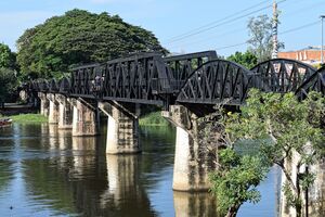
نهر خواي ياي
| نهر خواي ياي | |
|---|---|
 جسر سكك حديد بورما يعبر النهر في بلدة کانچانابوری. | |
 | |
| الاسم المحلي | แม่น้ำแควใหญ่ (تايلندية) |
| الموقع | |
| Country | تايلند |
| السمات الطبيعية | |
| المنبع | |
| ⁃ الموقع | Umphang District |
| المصب | |
- الموقع | کانچانابوری |
| الطول | 380 km |
| سمات الحوض | |
| النظام النهري | Mae Klong |
 | |
نهر خواي ياي (بالتايلندية: แม่น้ำแควใหญ่، RTGS: Maenam Khwae Yai، IPA: [mɛ̂ːnáːm kʰwɛː jàj] ؛ Khwae Yai River)، ويُعرف أيضاً بإسم سي سوات (แม่น้ำศรีสวัสดิ์ [mɛ̂ː náːm sǐː sa.wàt])، هو نهر في غرب تايلند. It has its source in the Tenasserim Hills and يسري لنحو 380 كم خلال Sangkhla Buri, Si Sawat, and Mueang Districts of محافظة کانچانابوری, where it merges with the Khwae Noi to form the Mae Klong River at Pak Phraek.
التاريخ
This river used to be the upper section (before the confluence with the Khwae Noi River) of the Mae Klong River, however, in the 1960s, this river was named the Khwae Yai River, meaning 'Big River.' [1]
In 1980, the Srinagarind Dam (Thai: เขื่อนศรีนครินทร์; rtgs: Khuean Sinakharin) on the Khwae Yai was completed in Si Sawat District of Kanchanaburi Province. It is an embankment dam for river regulation and hydroelectric power generation.
الجسر
الجسر الشهير التابع لـسكك حديد بورما يعبر النهر في Tha Makham Subdistrict of the Mueang District. However, this is not the same bridge as depicted in The Bridge over the River Kwai by Pierre Boulle and in its film adaptation. A bridge was built of wood approximately 100 متر (330 ft) upriver from the current bridge, during the construction of the iron and concrete bridge (which runs in a NNE-SSW direction) and also rebuilt in 1945 when the iron bridge was bombed. No remnants of the wooden bridge remain. That wooden bridge was also not the bridge depicted in the film as the river was not called the Kwai Yai at that time. A wooden trestle bridge was built over the Kwai Noi many miles upstream in the jungle and it would more closely resemble the bridge in the film. However, the film is really a fictional depiction of the events with many inaccuracies and neither bridge can really be said to be that depicted in the film.
Up until the 1960s, the river was considered part of the Mae Klong itself, but this part of the Mae Klong was then renamed Khwae Yai to bring geographical fact more in line with the fictional association with the name River Kwai. The main cemetery of prisoners who died during the railway's construction is nearby and is called the مقبرة کانچانابوری الحربية.
المراجع
- ^ "About River Kwai". River Kwai Jungle Rafts. Retrieved 2021-02-18.
{{cite web}}: CS1 maint: url-status (link)
وصلات خارجية
 وسائط متعلقة بـRiver Kwai Bridge من مشاع المعرفة.
- CS1 maint: url-status
- Pages using gadget WikiMiniAtlas
- Short description is different from Wikidata
- Articles with hatnote templates targeting a nonexistent page
- Infobox mapframe without OSM relation ID on Wikidata
- Articles containing تايلندية-language text
- Pages using infobox river with unknown parameters
- Coordinates on Wikidata
- أنهار تايلند
- جغرافيا محافظة کانچانابوری
- صفحات مع الخرائط