ممر سالنگ
| ممر سالنگ Salang Pass | |
|---|---|
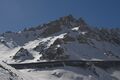
 طريق ملتوي في ممر سالنگ | |
| الارتفاع | 3٬878 م (12٬723 ق) |
| الموقع | أفغانستان |
| السلسلة | هندو كوش |
| الإحداثيات | 35°18′49.44″N 69°02′13.51″E / 35.3137333°N 69.0370861°E |
ممر سالنگ (فارسية: كتل سالنگ، إنگليزية: Salang Pass، على ارتفاع 3,878 متر فوق سطح البحر) هو الآن ممر جبلي رئيسي يربط شمال أفغانستان بـ ولاية پروان، ثم بوصلات لاحقة إلى ولاية كابول، إلى جنوب أفغانستان، وإلى إقليم خيبر پختونخوا الپاكستان.[1] وتحد ولاية پروان وولاية بغلان، وهي إلى الشرق مباشرة من ممر كوشان، وكان لكليهما أهمية فائقة في الأزمنة القديمة لأنهما كانا الوصلات الأكثر مباشرةً بين منطقة كابول وشمال أفغانستان أو تخارستان. ينبع نهر سالنگ بالقرب من الممر وينساب جنوباً.
يخترق الممر جبال هندو كوش إلا أنه فقد أهميته بعد إنشاء نفق سالنگ، الذي يمر تحته على عمق نحو 3,400 متر. الممر يربط Charikar and Kabul in the south with Mazar-i-Sharif and Kunduz in the north. Before the road and tunnel were built, the main route between Kabul and northern Afghanistan was via the Shibar Pass, a much longer route which took three days.[1]
The road through the pass has carried heavy military traffic in recent conflicts and is in very bad repair.[1]
الانهيارات الجبلية في فبراير 2010
On February 9, 2010, the pass was hit by multiple avalanches.[2][3] According to press reports the road through the pass was hit by 17 avalanches, killing dozens, burying miles of highway, and trapping the vehicles in the Salang tunnel. By February 10, 2010 authorities had recovered over 160 bodies.[4] Radio Free Europe reported the first avalanche blocked the tunnel, and trapped vehicles in a traffic jam in a "deadly avalanche zone".
معرض صور
-
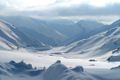 ممر سالنگ تغطيه ثلوج كثيفة في 30 يناير 2009
 -
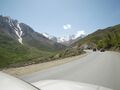 في الطريق إلى ممر سالنگ
 -
-
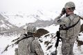 جنود أمريكان ينظرون إلى ممر سالنگ في مارس 2011
 -
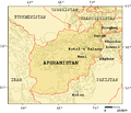 خريطة تبين الممرات الجبلية في أفغانستان


انظر أيضاً
- شمال سالنگ، قرية مجاورة
- قائمة الممرات الجبلية
المراجع
- ^ أ ب ت Library of Congress Country Study: Afghanistan Chapter 2: Mountains
- ^ Rod Norland (2010-02-09). "Avalanches Kill Dozens on Mountain Highway in Afghanistan". New York Times. Retrieved 2010-02-10.
Heavy winds and rain set off 17 avalanches that buried more than two miles of highway at a high-altitude pass in the Hindu Kush mountain range, entombing hundreds of cars and cutting off Kabul's heavily traveled link to northern Afghanistan, officials said Tuesday.
- ^ Rahim Faiez (2010-02-09). "Avalanches swamp Afghan pass: Scores of bodies pulled from cars as coalition joins search for injured". Toronto Star. Retrieved 2010-02-10.
A series of avalanches engulfed a mountain pass in Afghanistan, trapping hundreds of people in their buried cars and killing at least 24 people, authorities said Tuesday.
- ^ Ahmed Hanayesh, Ron Synovitz (2010-02-10). "From Afghan Avalanche, Tales Of Tragedy And Survival". Radio Free Europe/Radio Liberty. Retrieved 2010-02-10.
By the evening of February 10, authorities had recovered the bodies of more than 160 victims buried by a series of avalanches. The stories told to RFE/RL by survivors suggest the death toll could rise as search teams continue their work -- and when the spring thaw reveals the full extent of the tragedy. The first avalanche blocked the highway just south of the Salang Tunnel. As the traffic began to pile up, travelers in cars, trucks, and buses found themselves trapped in a deadly avalanche zone. Then, one after another, as many as 16 more avalanches wiped their vehicles off the road.

- Pages using gadget WikiMiniAtlas
- Articles with hatnote templates targeting a nonexistent page
- Coordinates on Wikidata
- Articles containing فارسية-language text
- Articles containing إنگليزية-language text
- Pages using Lang-xx templates
- الممرات الجبلية في أفغانستان
- تضاريس ولاية بغلان
- تضاريس ولاية كابول
- تضاريس ولاية پروان