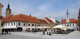
مقاطعة ڤاراجدين
مقاطعة ڤاراجدين
Varaždinska županija | |
|---|---|
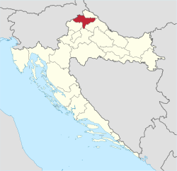 Varaždin County within Croatia | |
| البلد | كرواتيا |
| County seat | Varaždin |
| الحكومة | |
| • Župan | Anđelko Stričak (HDZ) |
| • Assembly | 41 members
|
| المساحة | |
| • الإجمالي | 1٬262 كم² (487 ميل²) |
| التعداد (2011)[2] | |
| • الإجمالي | 175٬951 |
| • الكثافة | 140/km2 (360/sq mi) |
| Area code | 042 |
| ISO 3166 code | HR-05 |
| HDI (2019) | 0.834[3] very high · 6th |
| الموقع الإلكتروني | varazdinska-zupanija |
مقاطعة ڤاراجدين (كرواتية: Varaždinska županija) هي مقاطعة في Hrvatsko Zagorje. وهي مسماة على اسم مقر المقاطعة، مدينة ڤاراجدين.
الجغرافيا
The county contains the city of Varaždin, the towns of: Ivanec, Ludbreg, Lepoglava, Novi Marof and Varaždinske Toplice, as well as 22 municipalities. It covers an area of 1،262 متر كيلومربع (487 sq mi) and had a population of 175,951 in the 2011 census.
Varaždin County borders Slovenia to the northwest, Međimurje County to the north, Krapina-Zagorje County to the southwest, مقاطعة زغرب to the south, and Koprivnica-Križevci County to the southeast, with a small portion of the latter separating it from Hungary.
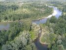
The Drava flows along the northern border of the county. There are three reservoirs on the river – Lake Ormož, Lake Varaždin and Lake Dubrava. All of them are partially located within the county. Another river flowing through the county is the Bednja, which also confluences with the Drava within the county. There are also the mountains of Ivanščica (also known as Ivančica) and كالنيك.
النقل
The highway A4 (part of Pan-European Corridor Vb and European route E65) passes through the county, connecting the Hungarian border (in the north) with Zagreb (in the south), and which has exits in Varaždin, Varaždinske Toplice and Novi Marof. In the longitudinal (east-west) direction, a magistral road passes along the Drava river, spanning من ماريبور (سلوڤينيا) إلى Osijek. Railways (not yet modernised) passing through the county lead to Zagreb in the south, Čakovec and Budapest (Hungary) in the north and Koprivnica في الشرق.
الاقتصاد
The economy of Varaždin County is focused on the manufacturing industry, particularly on the following industrial branches: milk products processing, beverage production, meat-packing industry, clothing and textiles industry, metal manufacturing industry, leather footwear industry, manufacturing of high-quality wood furniture and other lumber products.
التقسيم الإداري
مقاطعة ڤاراجدين تنقسم إلى:
- مدينة ڤاراجدين (مقر المقاطعة)
- بلدة Ludbreg
- بلدة Lepoglava
- Town of Ivanec
- Town of Novi Marof
- Town of Varaždinske Toplice
- Municipality of Bednja
- Municipality of Beretinec
- Municipality of Breznica
- Municipality of Breznički Hum
- Municipality of Cestica
- Municipality of Donja Voća
- Municipality of Donji Martijanec
- Municipality of Gornji Kneginec
- Municipality of Jalžabet
- Municipality of Klenovnik
- Municipality of Ljubešćica
- Municipality of Mali Bukovec
- Municipality of Maruševec
- Municipality of Petrijanec
- Municipality of Sračinec
- Municipality of Sveti Đurđ
- Municipality of Sveti Ilija
- Municipality of Trnovec Bartolovečki
- Municipality of Veliki Bukovec
- Municipality of Vidovec
- Municipality of Vinica
- Municipality of Visoko
السكان
|
| |||||||||||||||||||||||||||||||||||||||||||||||||||||||||
| Source: Naselja i stanovništvo Republike Hrvatske 1857–2001, Croatian Bureau of Statistics, Zagreb, 2005 | ||||||||||||||||||||||||||||||||||||||||||||||||||||||||||
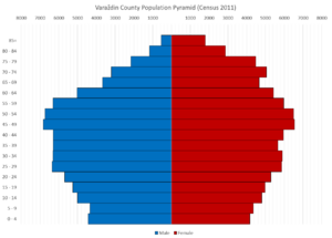
According to the 2011 census, Varaždin County has a population of 175,951.[2] Ethnic Croats make up a majority with 97.9% of the population.[4]
| population | 87960 | 99194 | 105612 | 120397 | 131849 | 144720 | 147524 | 159767 | 174682 | 177352 | 179905 | 184380 | 187495 | 187853 | 184769 | 175951 | 160264 |
| 1857 | 1869 | 1880 | 1890 | 1900 | 1910 | 1921 | 1931 | 1948 | 1953 | 1961 | 1971 | 1981 | 1991 | 2001 | 2011 | 2021 |
عرفان
- المواطنون الفخريون
- Zlatko Dalić (2018)[5]
انظر أيضاً
المراجع
- ^ قالب:Croatia Yearbook 2015
- ^ أ ب "Population by Age and Sex, by Settlements, 2011 Census: County of Varaždin". Census of Population, Households and Dwellings 2011. Zagreb: Croatian Bureau of Statistics. December 2012.
- ^ "Sub-national HDI - Area Database - Global Data Lab". hdi.globaldatalab.org (in الإنجليزية). Retrieved 2021-07-19.
- ^ "Population by Ethnicity, by Towns/Municipalities, 2011 Census: County of Varaždin". Census of Population, Households and Dwellings 2011. Zagreb: Croatian Bureau of Statistics. December 2012.
- ^ "Zlatko Dalić počasni građanin Varaždinske županije, vijećnici i župan uputili mu podršku uoči polufinala". varazdinska-zupanija.hr (in الكرواتية). Varaždin County. 11 July 2018. Archived from the original on 14 July 2018. Retrieved 9 July 2023.
وصلات خارجية
- Official website
 (in كرواتية)
- CS1 الكرواتية-language sources (hr)
- Pages using gadget WikiMiniAtlas
- Short description is different from Wikidata
- Pages using infobox settlement with no coordinates
- Articles containing كرواتية-language text
- Pages using Lang-xx templates
- Articles with كرواتية-language sources (hr)
- Coordinates on Wikidata
- مقاطعة ڤاراجدين
- مقاطعات كرواتيا
