مقاطعة وينيبيغو، إلينوي
مقاطعة وينيبيگو إنگليزية: Winnebago County هي إحدى المقاطعات في ولاية إلينوي في الولايات المتحدة.
Winnebago County | |
|---|---|
 City Hall in Rockford, Illinois. | |
 Seal | |
 Location within the U.S. state of Illinois | |
 موقع Illinois ضمن الولايات المتحدة | |
| الإحداثيات: Coordinates: 42°20′11″N 89°09′39″W / 42.33639°N 89.16083°W | |
| البلد | |
| State | |
| تأسست | January 16, 1836 |
| السمِيْ | Winnebago Tribe |
| Seat | Rockford |
| Largest city | Rockford |
| المساحة | |
| • الإجمالي | 519 ميل² (1٬340 كم²) |
| • البر | 513 ميل² (1٬330 كم²) |
| • الماء | 5٫9 ميل² (15 كم²) 1.1% |
| التعداد (2010) | |
| • الإجمالي | 295٬266 |
| • Estimate (2019) | 282٬572 |
| • الكثافة | 570/sq mi (220/km2) |
| منطقة التوقيت | UTC−6 (Central) |
| • الصيف (التوقيت الصيفي) | UTC−5 (CDT) |
| Congressional districts | 16th، 17th |
| الموقع الإلكتروني | www |
. . . . . . . . . . . . . . . . . . . . . . . . . . . . . . . . . . . . . . . . . . . . . . . . . . . . . . . . . . . . . . . . . . . . . . . . . . . . . . . . . . . . . . . . . . . . . . . . . . . . . . . . . . . . . . . . . . . . . . . . . . . . . . . . . . . . . . . . . . . . . . . . . . . . . . . . . . . . . . . . . . . . . . . .
التاريخ
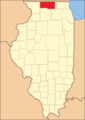
Winnebago County for its first year of existence
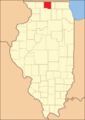
Winnebago County in 1837, reduced to its current borders by the creation of Stephenson and Boone Counties


الجغرافيا
According to the U.S. Census Bureau, the county has a total area of 519 square miles (1,340 km2), of which 513 square miles (1,330 km2) is land and 5.9 square miles (15 km2) (1.1%) is water.[1]
المناخ
| روكفورد، إلينوي | ||||||||||||||||||||||||||||||||||||||||||||||||||||||||||||
|---|---|---|---|---|---|---|---|---|---|---|---|---|---|---|---|---|---|---|---|---|---|---|---|---|---|---|---|---|---|---|---|---|---|---|---|---|---|---|---|---|---|---|---|---|---|---|---|---|---|---|---|---|---|---|---|---|---|---|---|---|
| جدول الطقس (التفسير) | ||||||||||||||||||||||||||||||||||||||||||||||||||||||||||||
| ||||||||||||||||||||||||||||||||||||||||||||||||||||||||||||
| ||||||||||||||||||||||||||||||||||||||||||||||||||||||||||||
In recent years, average temperatures in the county seat of Rockford have ranged from a low of 11 °F (−12 °C) in January to a high of 83 °F (28 °C) in July, although a record low of −27 °F (−33 °C) was recorded in January 1982 and a record high of 112 °F (44 °C) was recorded in July 1936. Average monthly precipitation ranged from 1.34 inches (34 mm) in February to 4.80 inches (122 mm) in June.[2]
. . . . . . . . . . . . . . . . . . . . . . . . . . . . . . . . . . . . . . . . . . . . . . . . . . . . . . . . . . . . . . . . . . . . . . . . . . . . . . . . . . . . . . . . . . . . . . . . . . . . . . . . . . . . . . . . . . . . . . . . . . . . . . . . . . . . . . . . . . . . . . . . . . . . . . . . . . . . . . . . . . . . . . . .
المقاطعات المجاورة
- Rock County, وسكنسن (شمال)
- Boone County (شرق)
- DeKalb County (جنوب شرق)
- Ogle County (جنوب)
- Stephenson County (غرب)
- Green County, وسكنسن (شمال غرب)
Demographics
| التعداد التاريخي | |||
|---|---|---|---|
| التعداد | Pop. | %± | |
| 1840 | 4٬609 | — | |
| 1850 | 11٬773 | 155٫4% | |
| 1860 | 24٬491 | 108�0% | |
| 1870 | 29٬301 | 19٫6% | |
| 1880 | 30٬505 | 4٫1% | |
| 1890 | 39٬938 | 30٫9% | |
| 1900 | 47٬845 | 19٫8% | |
| 1910 | 63٬153 | 32�0% | |
| 1920 | 90٬929 | 44�0% | |
| 1930 | 117٬373 | 29٫1% | |
| 1940 | 121٬178 | 3٫2% | |
| 1950 | 152٬385 | 25٫8% | |
| 1960 | 209٬765 | 37٫7% | |
| 1970 | 246٬623 | 17٫6% | |
| 1980 | 250٬884 | 1٫7% | |
| 1990 | 252٬913 | 0٫8% | |
| 2000 | 278٬418 | 10٫1% | |
| 2010 | 295٬266 | 6٫1% | |
| 2019 (تق.) | 282٬572 | [3] | −4٫3% |
| U.S. Decennial Census[4] 1790-1960[5] 1900-1990[6] 1990-2000[7] 2010-2019[8] | |||
As of the 2010 census, there were 295,266 people, 115,501 households, and 76,854 families residing in the county.[9] The population density was 575.2 inhabitants per square mile (222.1/km2). There were 125,965 housing units at an average density of 245.4 per square mile (94.7/km2).[1] The racial makeup of the county was 77.4% white, 12.2% black or African American, 2.3% Asian, 0.3% American Indian, 4.9% from other races, and 2.8% from two or more races. Those of Hispanic or Latino origin made up 10.9% of the population.[9] In terms of ancestry, 25.6% were German, 13.5% were Irish, 9.4% were American, 8.7% were Swedish, 8.3% were English, and 7.4% were Italian.[10]
Communities
Cities
Villages
Census-designated place
Unincorporated communities
Townships
Winnebago County is divided into these townships:
السياسة
Prior to 1992, Winnebago County was a Republican Party stronghold in presidential elections, only backing the Democratic Party candidates in the national landslides of 1936 & 1964. Since then, it has become a swing county, backing the national winner in every presidential election from 1980 to 2012. In 2016, Hillary Clinton won the county by only 89 votes over Donald Trump.
| Year | Republican | Democratic | Third parties |
|---|---|---|---|
| 2020 | 47.7% 60,861 | 50.2% 64,056 | 2.2% 2,792 |
| 2016 | 46.3% 55,624 | 46.4% 55,713 | 7.3% 8,718 |
| 2012 | 46.2% 55,138 | 51.7% 61,732 | 2.1% 2,527 |
| 2008 | 42.5% 53,886 | 55.3% 70,034 | 2.2% 2,784 |
| 2004 | 50.1% 60,782 | 49.2% 59,740 | 0.7% 903 |
| 2000 | 49.2% 53,816 | 47.6% 51,981 | 3.2% 3,500 |
| 1996 | 44.5% 44,479 | 46.3% 46,264 | 9.2% 9,167 |
| 1992 | 37.6% 42,221 | 43.0% 48,298 | 19.3% 21,696 |
| 1988 | 54.9% 55,699 | 44.6% 45,280 | 0.6% 571 |
| 1984 | 58.7% 64,203 | 40.8% 44,629 | 0.6% 619 |
| 1980 | 46.5% 48,825 | 30.8% 32,384 | 22.7% 23,880 |
| 1976 | 54.2% 52,736 | 43.5% 42,399 | 2.3% 2,252 |
| 1972 | 61.5% 57,682 | 38.3% 35,937 | 0.3% 231 |
| 1968 | 52.5% 47,646 | 40.5% 36,702 | 7.1% 6,391 |
| 1964 | 45.0% 39,920 | 55.0% 48,834 | 0.0% 0 |
| 1960 | 55.2% 49,541 | 44.7% 40,090 | 0.1% 110 |
| 1956 | 62.4% 48,332 | 37.5% 29,063 | 0.1% 89 |
| 1952 | 58.0% 43,468 | 41.9% 31,409 | 0.2% 127 |
| 1948 | 51.5% 29,537 | 47.4% 27,145 | 1.1% 631 |
| 1944 | 52.3% 30,837 | 47.2% 27,831 | 0.5% 277 |
| 1940 | 51.9% 30,683 | 47.5% 28,061 | 0.7% 383 |
| 1936 | 46.3% 24,997 | 50.4% 27,200 | 3.3% 1,792 |
| 1932 | 57.1% 26,632 | 38.0% 17,707 | 4.9% 2,286 |
| 1928 | 80.4% 33,258 | 18.6% 7,684 | 1.0% 430 |
| 1924 | 71.3% 21,978 | 7.2% 2,228 | 21.4% 6,608 |
| 1920 | 79.2% 19,913 | 13.4% 3,355 | 7.4% 1,866 |
| 1916 | 65.0% 14,893 | 27.1% 6,198 | 7.9% 1,806 |
| 1912 | 19.3% 2,537 | 17.3% 2,276 | 54.0% 7,089 |
| 1908 | 71.5% 8,919 | 17.4% 2,163 | 11.1% 1,385 |
| 1904 | 74.8% 8,143 | 10.8% 1,177 | 14.4% 1,567 |
| 1900 | 72.7% 8,103 | 22.4% 2,498 | 4.9% 546 |
| 1896 | 75.1% 8,242 | 22.3% 2,447 | 2.6% 286 |
| 1892 | 62.5% 5,854 | 28.1% 2,634 | 9.4% 878 |
. . . . . . . . . . . . . . . . . . . . . . . . . . . . . . . . . . . . . . . . . . . . . . . . . . . . . . . . . . . . . . . . . . . . . . . . . . . . . . . . . . . . . . . . . . . . . . . . . . . . . . . . . . . . . . . . . . . . . . . . . . . . . . . . . . . . . . . . . . . . . . . . . . . . . . . . . . . . . . . . . . . . . . . .
انظر أيضاً
المراجع
- المحددة
- ^ أ ب "Population, Housing Units, Area, and Density: 2010 - County". United States Census Bureau. Archived from the original on February 12, 2020. Retrieved 2015-07-12.
- ^ أ ب "Monthly Averages for Rockford, Illinois". The Weather Channel. Retrieved 2011-01-27.
- ^ "Population and Housing Unit Estimates". Retrieved March 26, 2020.
- ^ "U.S. Decennial Census". United States Census Bureau. Retrieved July 9, 2014.
- ^ "Historical Census Browser". University of Virginia Library. Retrieved July 9, 2014.
- ^ "Population of Counties by Decennial Census: 1900 to 1990". United States Census Bureau. Retrieved July 9, 2014.
- ^ "Census 2000 PHC-T-4. Ranking Tables for Counties: 1990 and 2000" (PDF). United States Census Bureau. Retrieved July 9, 2014.
- ^ خطأ استشهاد: وسم
<ref>غير صحيح؛ لا نص تم توفيره للمراجع المسماةQF - ^ أ ب "DP-1 Profile of General Population and Housing Characteristics: 2010 Demographic Profile Data". United States Census Bureau. Archived from the original on February 13, 2020. Retrieved 2015-07-12.
- ^ "DP02 SELECTED SOCIAL CHARACTERISTICS IN THE UNITED STATES – 2006-2010 American Community Survey 5-Year Estimates". United States Census Bureau. Archived from the original on February 13, 2020. Retrieved 2015-07-12.
- ^ Leip, David. "Dave Leip's Atlas of U.S. Presidential Elections". uselectionatlas.org. Retrieved 19 March 2018.
- العامة
للاستزادة
- Shaw, Adele Marie (June 1904). "Common-Sense Country Schools: How Superintendent kern Has Revolutionized Rural Education In Winnebago County, Illinois". The World's Work: A History of Our Time. VIII: 4883–4894. Retrieved 2009-07-10. Includes numerous photos of c. 1904 Winnebago County schools.
- Church, Charles A. (1900). History of Rockford and Winnebago County, Illinois, from the first settlement in 1834 to the civil war. Rockford, Ill.: W.P. Lamb, printer. p. 430.
- The History of Winnebago County, Illinois : its past and present. Chicago: H. F. Kett & Co. 1877. p. 664.