مقاطعة إدواردز، إلينوي
مقاطعة إدوردز إنگليزية: Edwards County هي إحدى المقاطعات في ولاية إلينوي في الولايات المتحدة. As of the 2010 census, the population was 6,721.[1] Its county seat is Albion.[2] It is located in the southern portion known locally as "Little Egypt".
Edwards County | |
|---|---|
 محكمة مقاطعة إدواردز في ألبيون | |
 Location within the U.S. state of إلينوي | |
 موقع إلينوي ضمن الولايات المتحدة | |
| الإحداثيات: Coordinates: 38°25′N 88°04′W / 38.42°N 88.06°W | |
| البلد | |
| State | |
| تأسست | 1814 |
| السمِيْ | نينيان إدواردز |
| Seat | ألبيون |
| Largest city | ألبيون |
| المساحة | |
| • الإجمالي | 223 ميل² (580 كم²) |
| • البر | 222 ميل² (570 كم²) |
| • الماء | 0٫3 ميل² (0٫8 كم²) 0.1% |
| التعداد (2010) | |
| • الإجمالي | 6٬721 |
| • Estimate (2018) | 6٬392 |
| • الكثافة | 30/sq mi (12/km2) |
| منطقة التوقيت | UTC−6 (Central) |
| • الصيف (التوقيت الصيفي) | UTC−5 (CDT) |
| Congressional district | 15th |
. . . . . . . . . . . . . . . . . . . . . . . . . . . . . . . . . . . . . . . . . . . . . . . . . . . . . . . . . . . . . . . . . . . . . . . . . . . . . . . . . . . . . . . . . . . . . . . . . . . . . . . . . . . . . . . . . . . . . . . . . . . . . . . . . . . . . . . . . . . . . . . . . . . . . . . . . . . . . . . . . . . . . . . .
التاريخ
مقاطعة إدواردز مسماة على اسم نينيان إدواردز،[3] the governor of the Illinois Territory, and, later, governor of Illinois.
Edwards County is subdivided into "Road Districts", rather than "Townships" as in most Illinois counties. Pursuant to the Land Ordinance of 1785, the Northwest Territory (including Illinois) was surveyed and mostly organized into townships that are six miles square; but Edwards County was settled prior to that survey, and its pre-existing Road Districts do not generally correspond with the survey's townships.
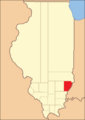
The county between 1819 and 1821. At this point Crawford County was split off from Edwards, and Wayne Counties.
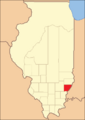
Edwards between 1821 and 1824
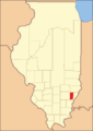
Edwards in 1824, reduced to its current size by the creation of Wabash County


الجغرافيا
المناخ
| ألبيون، إلينوي | ||||||||||||||||||||||||||||||||||||||||||||||||||||||||||||
|---|---|---|---|---|---|---|---|---|---|---|---|---|---|---|---|---|---|---|---|---|---|---|---|---|---|---|---|---|---|---|---|---|---|---|---|---|---|---|---|---|---|---|---|---|---|---|---|---|---|---|---|---|---|---|---|---|---|---|---|---|
| جدول الطقس (التفسير) | ||||||||||||||||||||||||||||||||||||||||||||||||||||||||||||
| ||||||||||||||||||||||||||||||||||||||||||||||||||||||||||||
| ||||||||||||||||||||||||||||||||||||||||||||||||||||||||||||
In recent years, average temperatures in the county seat of Albion have ranged from a low of 21 °F (−6 °C) in January to a high of 89 °F (32 °C) in July, although a record low of −20 °F (−29 °C) was recorded in January 1982 and a record high of 109 °F (43 °C) was recorded in July 1954. Average monthly precipitation ranged from 2.57 inches (65 mm) in January to 5.13 inches (130 mm) in April.[4]
. . . . . . . . . . . . . . . . . . . . . . . . . . . . . . . . . . . . . . . . . . . . . . . . . . . . . . . . . . . . . . . . . . . . . . . . . . . . . . . . . . . . . . . . . . . . . . . . . . . . . . . . . . . . . . . . . . . . . . . . . . . . . . . . . . . . . . . . . . . . . . . . . . . . . . . . . . . . . . . . . . . . . . . .
السياسة
| Year | Republican | Democratic | Third parties |
|---|---|---|---|
| 2020 | 84.2% 2,833 | 14.5% 488 | 1.3% 45 |
| 2016 | 83.6% 2,778 | 13.1% 434 | 3.4% 112 |
| 2012 | 74.5% 2,405 | 23.4% 754 | 2.1% 69 |
| 2008 | 63.6% 2,137 | 33.9% 1,140 | 2.5% 85 |
| 2004 | 71.7% 2,412 | 27.7% 930 | 0.7% 22 |
| 2000 | 67.9% 2,212 | 30.0% 978 | 2.2% 70 |
| 1996 | 52.0% 1,613 | 35.1% 1,089 | 12.9% 401 |
| 1992 | 45.1% 1,601 | 36.6% 1,299 | 18.4% 652 |
| 1988 | 64.1% 2,212 | 35.3% 1,218 | 0.6% 20 |
| 1984 | 72.3% 2,778 | 27.5% 1,057 | 0.3% 10 |
| 1980 | 68.1% 2,556 | 27.8% 1,041 | 4.1% 154 |
| 1976 | 58.5% 2,379 | 40.5% 1,648 | 1.0% 39 |
| 1972 | 73.9% 3,017 | 25.9% 1,055 | 0.2% 9 |
| 1968 | 63.7% 2,633 | 26.5% 1,095 | 9.9% 407 |
| 1964 | 53.2% 2,262 | 46.8% 1,991 | |
| 1960 | 69.4% 3,291 | 30.5% 1,446 | 0.2% 8 |
| 1956 | 73.4% 3,339 | 26.6% 1,210 | 0.0% 1 |
| 1952 | 75.0% 3,502 | 24.9% 1,162 | 0.1% 5 |
| 1948 | 66.1% 2,491 | 32.0% 1,206 | 1.9% 73 |
| 1944 | 71.0% 3,016 | 28.2% 1,197 | 0.9% 37 |
| 1940 | 64.9% 3,361 | 34.2% 1,770 | 1.0% 51 |
| 1936 | 55.2% 2,813 | 43.4% 2,211 | 1.5% 76 |
| 1932 | 52.3% 2,203 | 46.4% 1,956 | 1.4% 57 |
| 1928 | 74.8% 2,861 | 24.8% 950 | 0.4% 15 |
| 1924 | 69.6% 2,750 | 26.5% 1,047 | 3.9% 155 |
| 1920 | 79.2% 3,002 | 19.6% 742 | 1.2% 46 |
| 1916 | 65.4% 2,885 | 31.5% 1,389 | 3.1% 138 |
| 1912 | 34.0% 817 | 27.0% 650 | 38.9% 936[أ] |
| 1908 | 64.5% 1,614 | 29.8% 747 | 5.7% 142 |
| 1904 | 67.3% 1,610 | 24.9% 595 | 7.9% 188 |
| 1900 | 64.2% 1,577 | 33.5% 823 | 2.3% 57 |
| 1896 | 64.0% 1,572 | 34.7% 852 | 1.4% 34 |
| 1892 | 62.6% 1,350 | 31.4% 677 | 6.0% 130 |
In other positions the county has been not been consistently Republican for as long, but nevertheless has been so for many years. The last Democratic Senatorial candidate it backed was Alan J. Dixon in 1986[6] and the last Democratic gubernatorial candidate it supported was Glenn Poshard, who carried all of Southern Illinois in his failed 1998 bid.[7] Edwards County lies in Illinois's 15th congressional district, which has Cook Partisan Voting Index of R+21 and has been represented by Republican Mary Miller since 2021. In more local positions the county is in the 109th district of the Illinois House of Representatives so is represented by Republican Darren Bailey and is in the Illinois Senate it lies in the 55th district and is represented by Republican Dale Righter.[8]
Edwards County is a dry county, with multiple referenda to allow alcohol sales failing in the mid-1990s. The portion of Grayville, Illinois that lies within Edwards County does allow alcohol sales per Grayville city ordinance.[9]
ملاحظات
- ^ There were only 818 votes for the leading “other” candidate, Progressive Theodore Roosevelt, plus 100 for the Prohibition Party’s Eugene Chafin, 16 for Socialist Eugene Debs, and 3 for Socialist Labor candidate Arthur Reimer.
References
- United States Census Bureau 2007 TIGER/Line Shapefiles
- United States Board on Geographic Names (GNIS)
- United States National Atlas
- ^ "State & County QuickFacts". United States Census Bureau. Archived from the original on June 6, 2011. Retrieved July 4, 2014.
- ^ "Find a County". National Association of Counties. Archived from the original on July 4, 2012. Retrieved 2011-06-07.
- ^ Gannett, Henry (1905). The Origin of Certain Place Names in the United States. Govt. Print. Off. pp. 115.
- ^ أ ب "Monthly Averages for Albion, Illinois". The Weather Channel. Retrieved 2011-01-27.
- ^ Leip, David. "Dave Leip's Atlas of U.S. Presidential Elections". uselectionatlas.org.
- ^ "David Leip's Election Atlas (Maps for Illinois Senate by election)". uselectionatlas.org.
- ^ "David Leip's Election Atlas (Maps for Illinois Governor by election)". uselectionatlas.org.
- ^ "District Map & General Information - Senator Dale Righter - Dale Righter, Illinois State Senator – 55th District". dalerighter.com. Archived from the original on November 9, 2014. Retrieved November 9, 2014.
- ^ "Illinois Liquor Control Commission Home" (PDF). www.state.il.us.